Cary67
-
Posts
1,572 -
Joined
-
Last visited
Content Type
Profiles
Blogs
Forums
American Weather
Media Demo
Store
Gallery
Everything posted by Cary67
-
Even though under WWA expect maybe 1" of slop far SE McHenry. Maybe 2-3" up on the IL/WI border
-
About 1" down
-
Brylcreem system. "A little DAB'll do ya"
-
Winter 2023/24 Medium/Long Range Discussion
Cary67 replied to Chicago Storm's topic in Lakes/Ohio Valley
Normally don't put the snowblower away till 1st week of April. Thinking of retiring it early. -
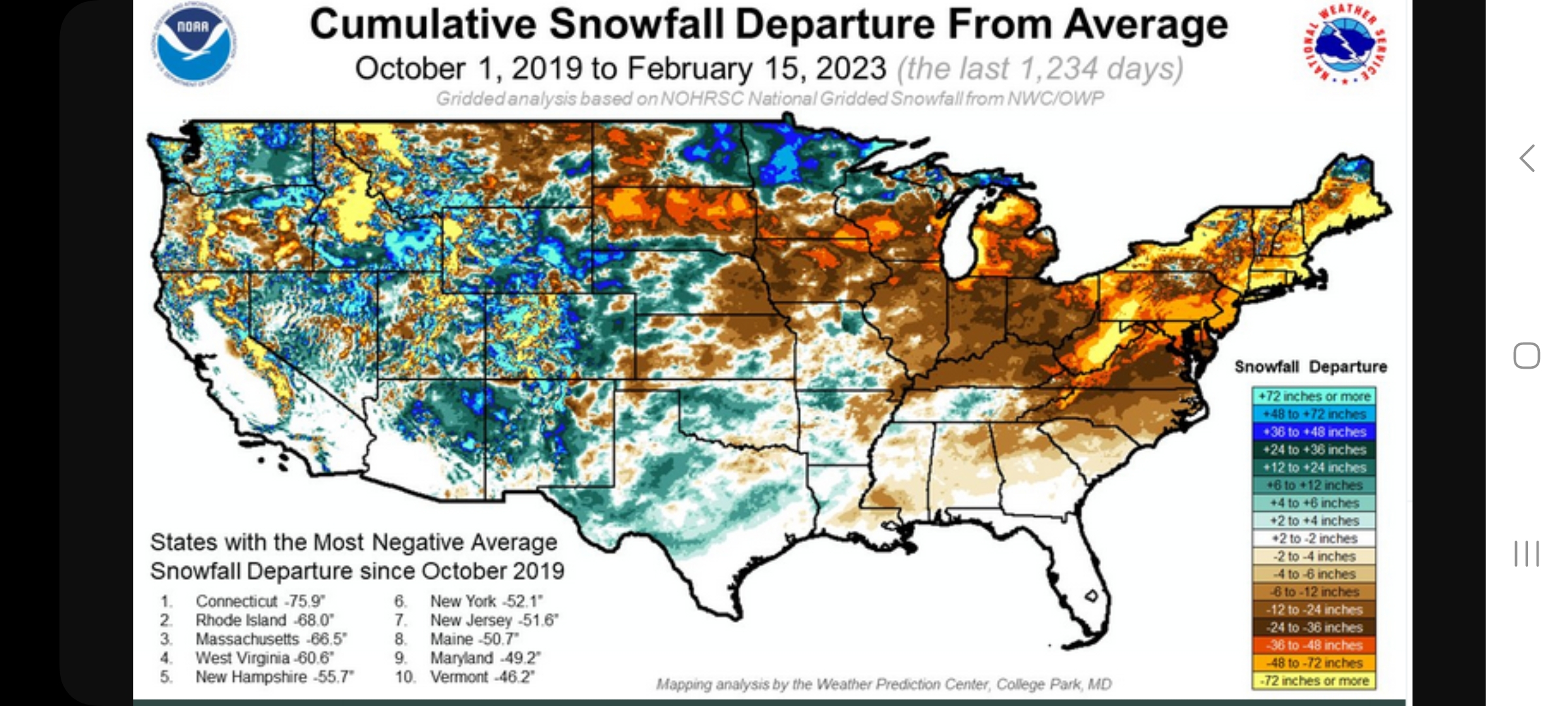
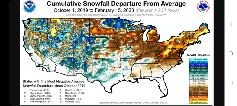
It seems accurate for my area but maybe not so much for others. Have to think this winter will only further the departures shown in a lot of the midwest that are lagging in snowfall over the last five winters.
-
This winter should enhance this map nicely.
-
Winter 2023/24 Medium/Long Range Discussion
Cary67 replied to Chicago Storm's topic in Lakes/Ohio Valley
The question of will it snow on Easter has to be dealt with. -
I am almost as far north at 42.18 latitude as Detroit yet you guys seem to outperform us in snowfall averages. Is that just lake influence or does your area receive more synoptic snows?
-
Winter 2023/24 Medium/Long Range Discussion
Cary67 replied to Chicago Storm's topic in Lakes/Ohio Valley
Not sure if this is definitive about a SSW cancel but maybe you have some insight. Post stated 100% of ensembles had a reversal on the SSW with PV remaining intact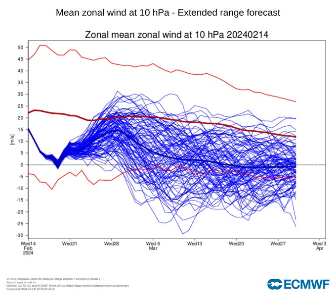
-
I think Detroit averages 45"seasonal snowfall compared to 37-38" for Chicago. I've had several winters recently under 25" seasonal snowfall yet Michigansnowfreak has only experienced one winter in 29 years like that. Big dogs happen so infrequently in Chicago I'd take the consistent yearly snow advantage you have. But understand your point
-
2024 Short/Medium Range Severe Weather Discussion
Cary67 replied to Chicago Storm's topic in Lakes/Ohio Valley
Nice! Did I say winter was monotonous. Lol -
With the exception of a couple weeks in January and the last few days of spring like weather its monotonously unappealing. 4.5 months of temps 30-45F with cold rain the predominating precip is a tough road to grind through. Loss of December as a winter month is a killer. Below average March and April's just extend the monotony but can't replace losing December.
-
Not CAD but SAD( seasonable and dry)
-
Winter 2023/24 Medium/Long Range Discussion
Cary67 replied to Chicago Storm's topic in Lakes/Ohio Valley
Euro and CMC want to bring back a Jan.11-13th track system. Right ahead of the mid month cold push. -
Winter 2023/24 Medium/Long Range Discussion
Cary67 replied to Chicago Storm's topic in Lakes/Ohio Valley
From LOT AFD: pressed south by blocking over central NOAM, we`ll have an exceptionally long period of benign weather with surface high pressure predominating through mid next week. Winds will be generally from the northeast, resulting in rare winter time "cooler near the lake" conditions lakeside amidst otherwise well above normal temperatures in the 40s (with upside potential pending sky cover trends). Next chance of precipitation will come beyond day 7. The tendency during this stretch will be to wonder if "winter is over", though consistent long range ensemble guidance has been pointing toward the return of a more wintry pattern (western ridging and eastern troughing with high latitude blocking establishing), at least temperature wise, toward Valentine`s Day. Castro -
Winter 2023/24 Medium/Long Range Discussion
Cary67 replied to Chicago Storm's topic in Lakes/Ohio Valley
The springs in N.IL and especially by the lake have always been short and sucky with some exceptions. For the most part it's mid to late April till mid to late May. I think the loss of December whether its an El Nino or La Nina isn't compensated enough by cold Marches. The winter windows of opportunity seem to be narrowing in length and frequency. It highlights the fewer winners vs all the losers even more so in areas solely relying on synoptic snowfall. LES areas still have the buffer of receiving snow when cold air makes its brief intrusions. -
Winter 2023/24 Medium/Long Range Discussion
Cary67 replied to Chicago Storm's topic in Lakes/Ohio Valley
If this happens the NWS may have to issue a CAD watch for Alek -
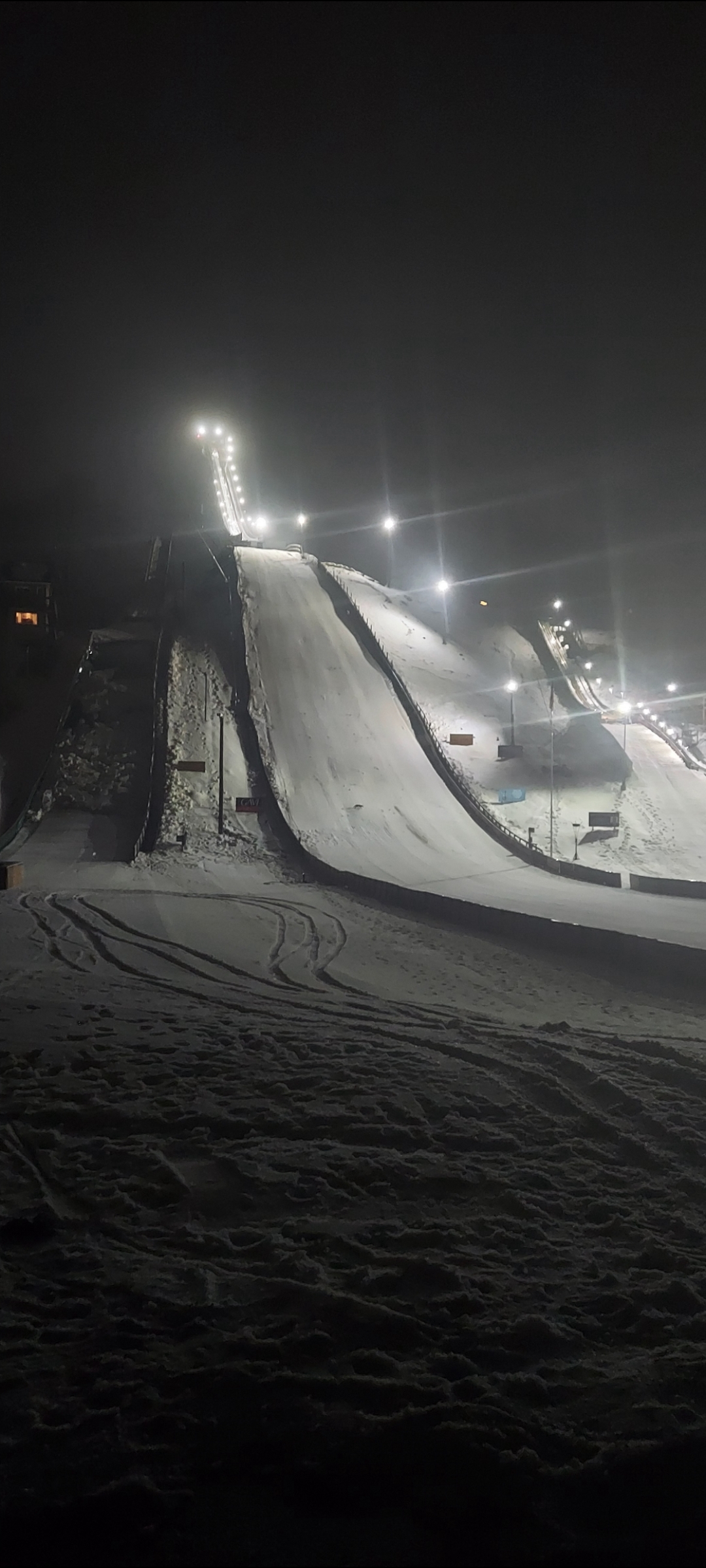
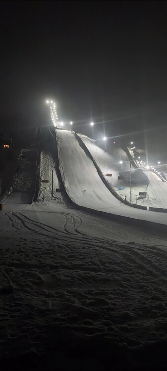
Good thing we hung onto some snow as Norgi ski jump festival is this weekend.
-
24 miles NW
-
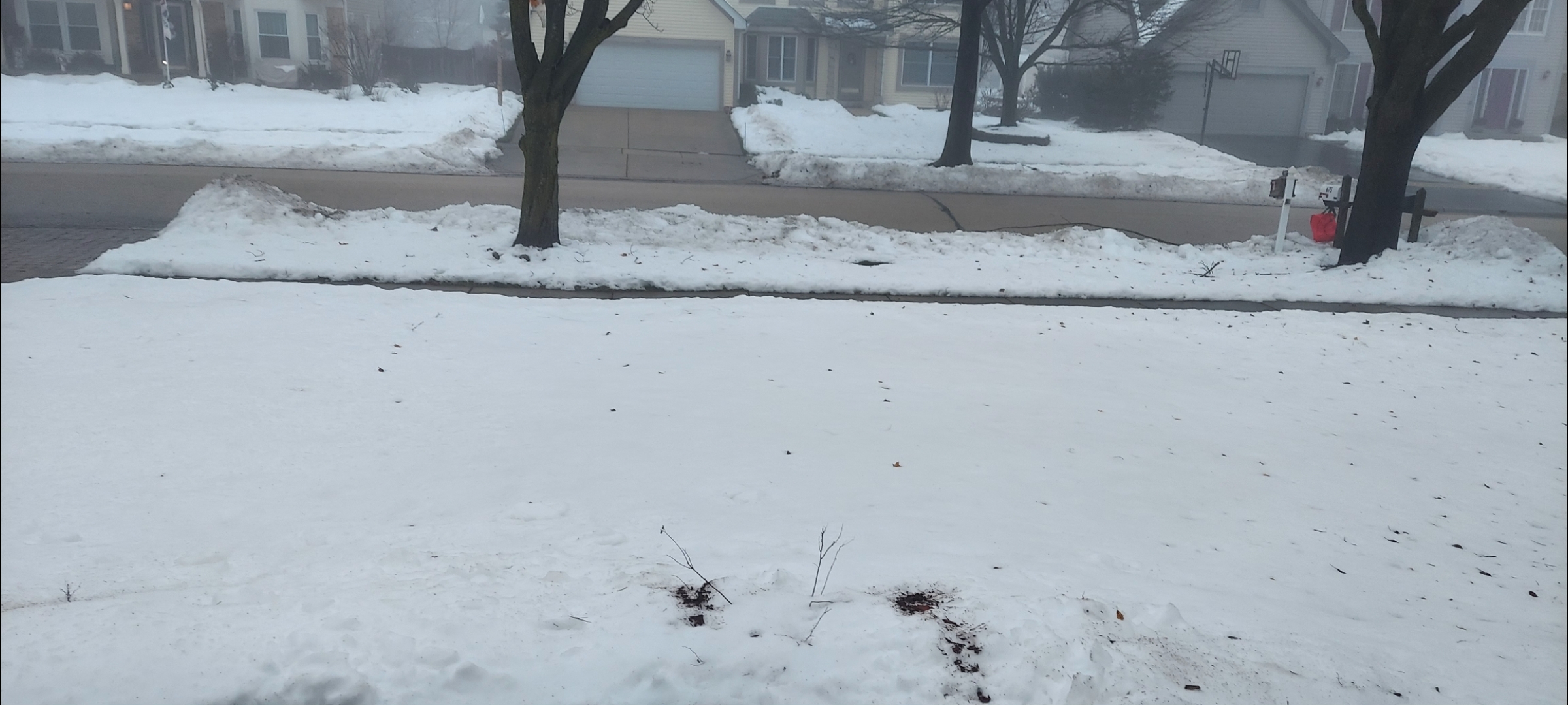
Yeah this fog is relentless. Snow melt is progressing but slowly.

-
Winter 2023/24 Medium/Long Range Discussion
Cary67 replied to Chicago Storm's topic in Lakes/Ohio Valley

-
Did Someone Say Clipper(Hybrid)!?! 1/18-1/19
Cary67 replied to Frog Town's topic in Lakes/Ohio Valley
Was that mostly LES? -
Probably the high water mark for snow depth and that deep winter feel. Some ZR then the great melt
-
Did Someone Say Clipper(Hybrid)!?! 1/18-1/19
Cary67 replied to Frog Town's topic in Lakes/Ohio Valley
Frontogenic magic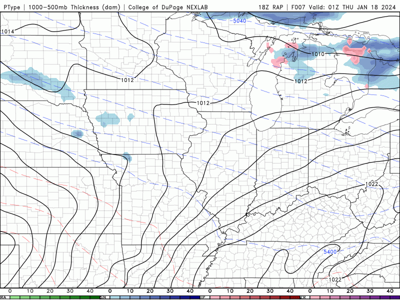
-
Sadly looks like Norgi ski weekend on Jan.27-28th could be a slop fest if rain and warmth next week comes to fruition.