EastTNWeatherAdmirer
-
Posts
45 -
Joined
-
Last visited
Content Type
Profiles
Blogs
Forums
American Weather
Media Demo
Store
Gallery
Everything posted by EastTNWeatherAdmirer
-
1-30/2-1-26 Arctic Blast, ULL Snow Event
EastTNWeatherAdmirer replied to John1122's topic in Tennessee Valley
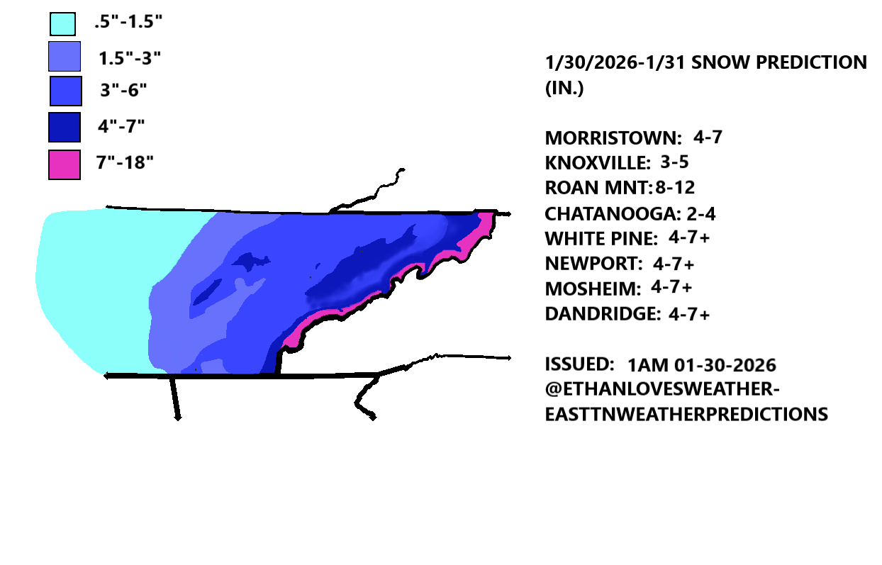
This is my snowfall forecast map and cities Jefferson City: 4”-6”+ Morristown: 4”-7”+ Knoxville (downtown; East & South): 3”-5” Newport: 4”-7” + Kingsport: 3.5”-6” Greenville: 4”-7”+ Baneberry: 4”-7”+ White Pine: 4”-7”+ Mt. LeConte (including Sunday NW flow mnt snowfall): 12”-16”+ Sevierville: 5”-7”+ Pitman Center: 6”-8”+ Cosby (in the actual town near foothills pkwy; not at Wilton Springs): 5”-8”+ Tazewell: 3”-5.5” Johnson City: 5”-8” + Maryville: 3.5”-6” Roan Mountain (including Sunday NW flow mnt snowfall): 10”-16”+ Sweetwater: 3”-5” Athens: 3”-5” Chattanooga: 2”-4” Crossville: 3”-4” -Clinton, Halls, Powell, & Karns: 2”-4” (less than east and south Knox County) -Dandridge: 4”-7”+ -Chestnut Hill: 4”-7”+ -White Pine, Baneberry, Bybee: 5”-7”+ (enhanced accumulation here) -Russellville: 4.5”-6” -Mohawk, Mosheim, & Midway (Greene County): 5”-8” -Bristol (not counting Saturday night & Sunday snow showers): 4”-5.5” -Parrottsville (Cocke County): 5”-7”+
- 782 replies
-
- 4
-

-
- extreme cold
- snow
- (and 1 more)
-
January 15th-17th 2024 Arctic Blast/Snow Event
EastTNWeatherAdmirer replied to John1122's topic in Tennessee Valley
While this may be my own forecasting “anti-bias” / cautious & pessimistic forecasting attitude taking hold, but I don’t like the look of the end of today’s 18z Nam for eastern areas if one wants snow. We haven’t had the actual arctic air yet arrive from behind the current system and it remains to be seen just how robust this arctic air is when it moves in Sunday. I feel pretty confident western and middle tn folks are on board to see some decent accumulation, but the potential is there for this swath of snow to shift 50-100 miles north of the current forecasted area for East Tennessee if deep cold thickness lines end up not being as far south and shift sw to ne like the end of the latest nam 12km is indicating. This is exactly what happened on January 5th, 2022 with the snow expected to hit pretty much all of East Tennessee with 3”-5” anticipated, however, in reality, all of East Tennessee barely received a trace or even 1/2” with most of the moderate to heavy snow going to our north and west with milder and drier air over all of East Tennessee. I’m not saying this is what will happen with this upcoming system because I’m sure different dynamics are at play and the Nam isn’t necessarily spot on at hr 84, but I did get a small dose of PTSD when I saw the end of the NAM and connected that to Jan 5th 2022. -
Jan Medium/Long Range Disco: Winter is coming
EastTNWeatherAdmirer replied to stormtracker's topic in Mid Atlantic
Absolutely excellent analysis. I like how you explained how a -NAO isn’t always necessarily a rule of thumb for whether or not it will be cold and snowy in the south and East because of how it could fully lat connect with the SER when there’s a -PNA / western trough. Last winter we all learned the lesson that a -NAO doesn’t necessarily mean cold and snow in the mid Atlantic when there’s a hostile pacific driving the trough into SW Canada. Great stuff -
Dec/Jan Medium/Long Range Disco
EastTNWeatherAdmirer replied to WinterWxLuvr's topic in Mid Atlantic
Who knows if the JMA is even worth checking out and I wish I could see the surface precip with it, but it shows a significant storm for Jan 2nd over the mid Atlantic. Probably won’t verify of course, but this seems like the most bullish model on this storm yet.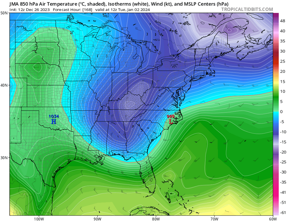
-
A stupid little poem I wrote: With the Upper Level Low Elevation is key The higher you go The more snow will be So weatherman be woe even though big snow maps are to see we must say no
-
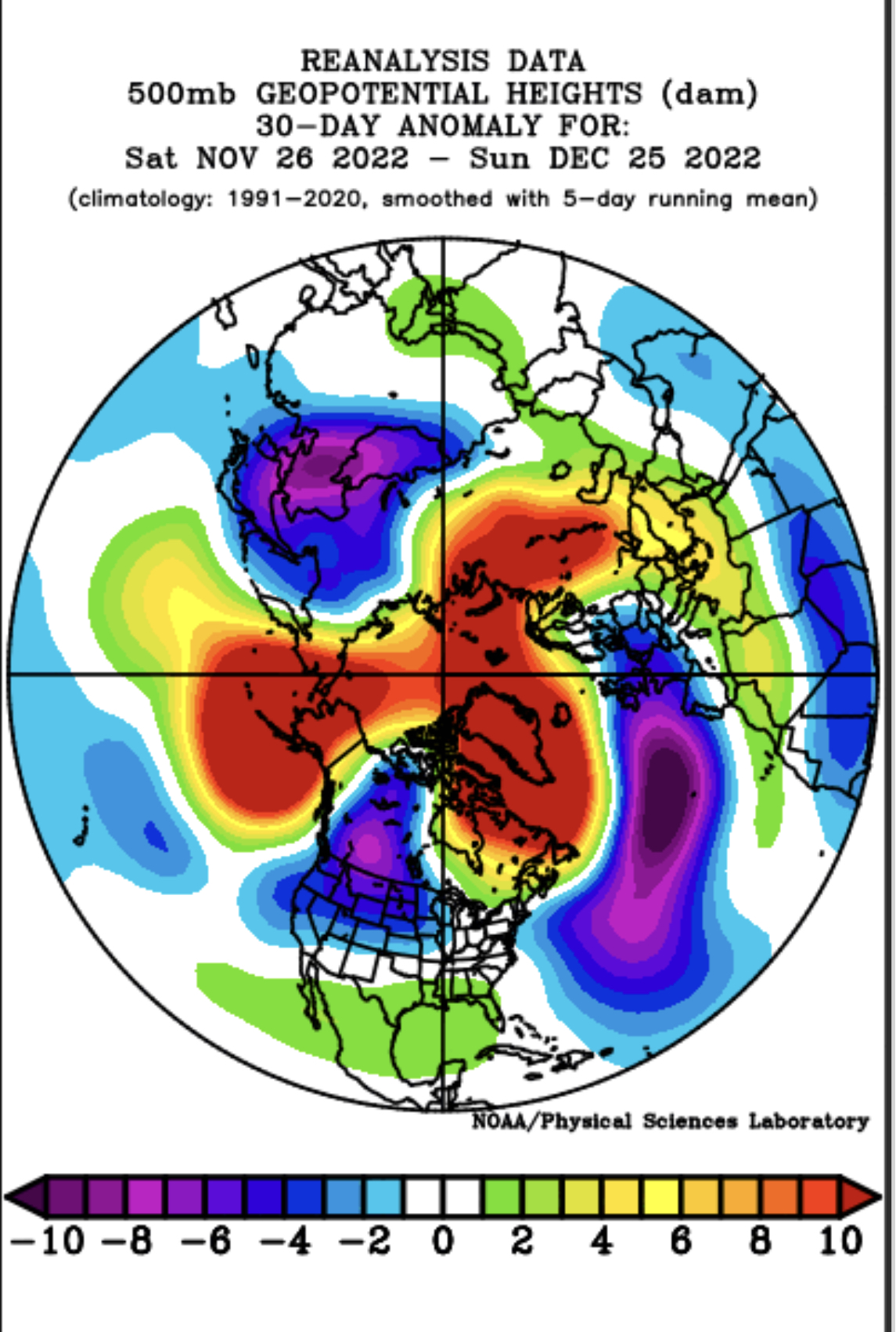
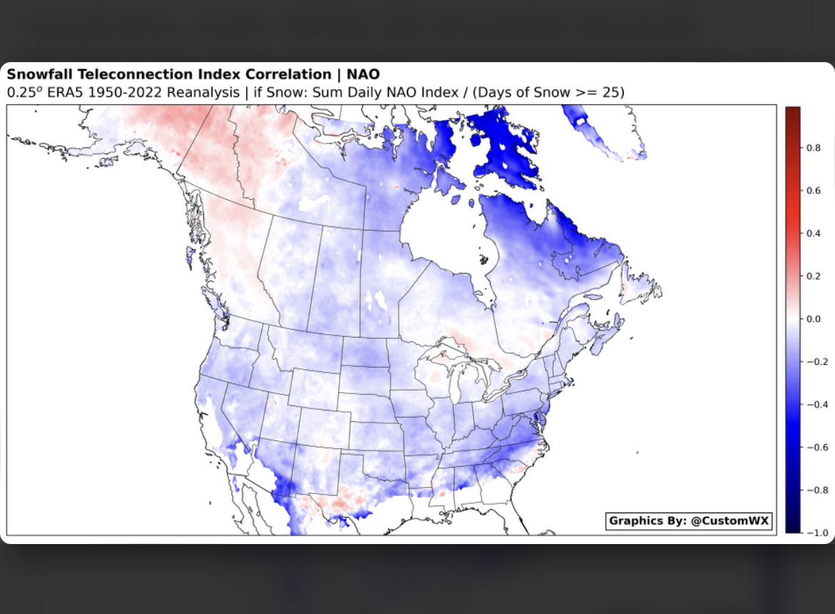
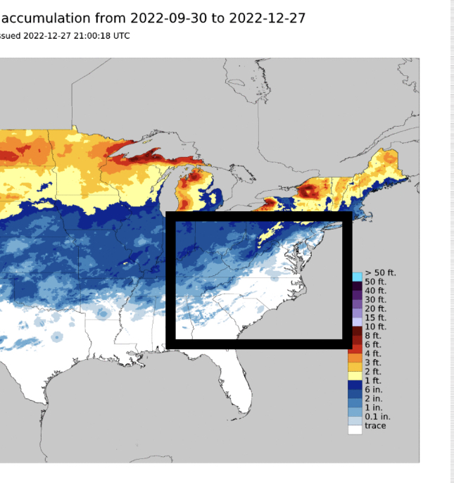
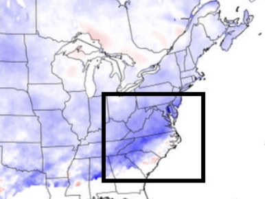
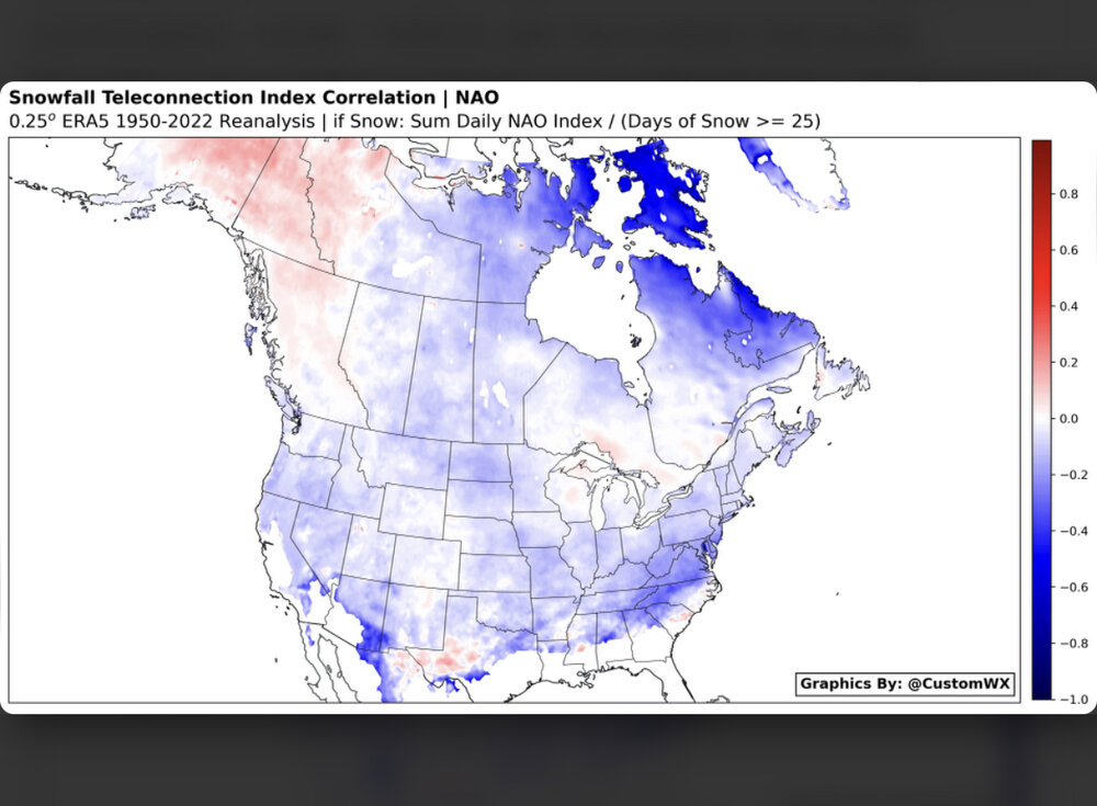
Hi Carvers, thank you for your responses. Do you think there is any particular reason there was no 50/50 low with this negative NAO? If the strong - NAO wasn’t a factor in it being present this year, then there must be something else at play, some confounding variable that is or isn’t inclined to the development of a 50/50 low. And subsequently without this low, no Mid-Atlantic snowstorm was generated where the -NAO usually brings big snow. One of the images below is the snowfall anomaly trend with -NAOs and the other is the snowfall we have seen this season so far. There has been very little to no snow where the most snow typically falls with a -NAO(such as the western N.C. Piedmont), as I have highlighted in the black boxes.
- 923 replies
-
- 1
-

-
- warm start
- cold
- (and 4 more)
-
The Greenland block is much less closed off this year. If it was closed off that we would have no problem with warm coming up the eastern seaboard ahead of the cold air intrusions.
- 923 replies
-
- 1
-
-
- warm start
- cold
- (and 4 more)
-
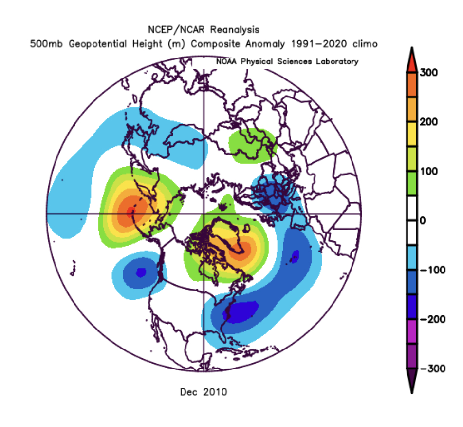
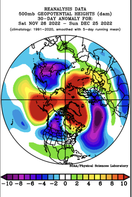
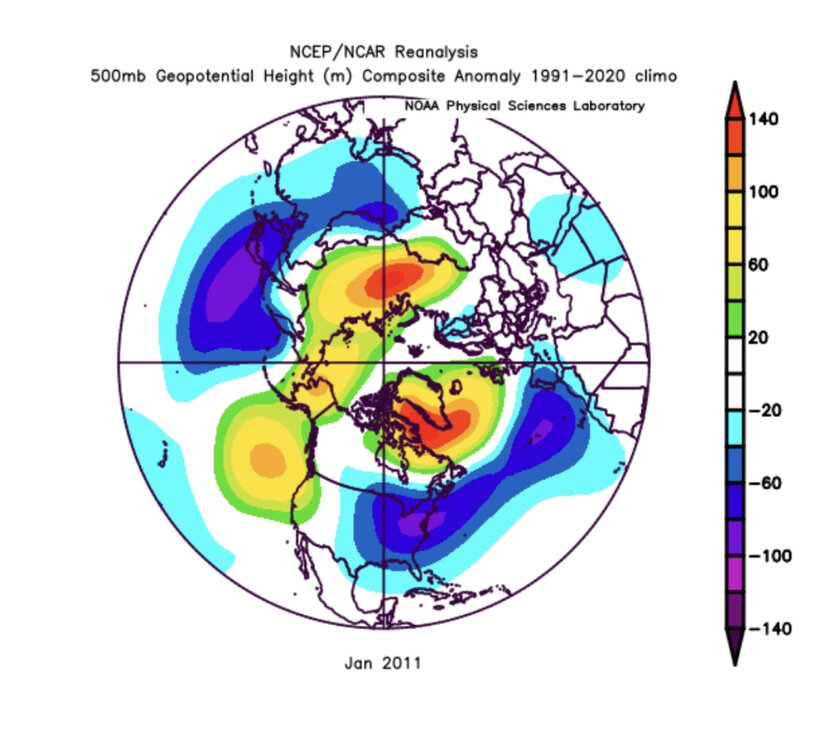
Here is one response I got on Southern WX when I inquired about the NAO earlier this month. Basically, yeah it’s the absence of the 50/50 low which was caused trouble and this is because the block over the HB region is much less closed off than it was in 2010. Here are some more images which help to tell the story:


- 923 replies
-
- 1
-
-
- warm start
- cold
- (and 4 more)
-
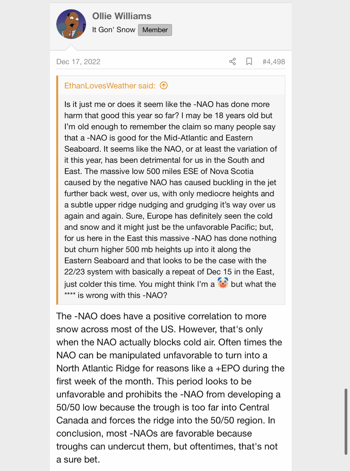
But I guess we didn’t have much snow this December in the Southeast because we didn’t have much help from the Pacific, Carvers? Maybe that could be the case or the HB block(-NAO) is behaving differently than your typical -NAO. If it behaved like a traditional -NAO we would have had a shot at several December snows. An example of the HB block being a good thing(as itryatgolf70 is saying) was December and January of 2010 when we had the HB block much more “CLOSED OFF” and also perhaps had help from back west, allowing cold air to actually be blocked by the -NAO(Hudson Bay) block. It does seem like the -NAO has behaved a little different this year in December 2022 than your typical one that blocks cold air over the south and east, forcing big southern snow and overrunning. It’s almost like the block over the HB region this year wasn’t fully autonomous but had a connection with the SER(as golf man was saying), instead of there being a massive 50/50 low, as in 2010. This year’s NAO does seem like it has created zonal flow like Carvers was saying but traditionally is pretty good for significant snow in the south when it’s not trying to connect with the SE ridge or hurt by the pacific pattern, as it was this year. Plenty of snow in December 2010 defying the climo I suppose.
- 923 replies
-
- 5
-
-
- warm start
- cold
- (and 4 more)
-
Historic Christmas Cold & maybe snow?! Dec 23rd-30th
EastTNWeatherAdmirer replied to Wurbus's topic in Tennessee Valley
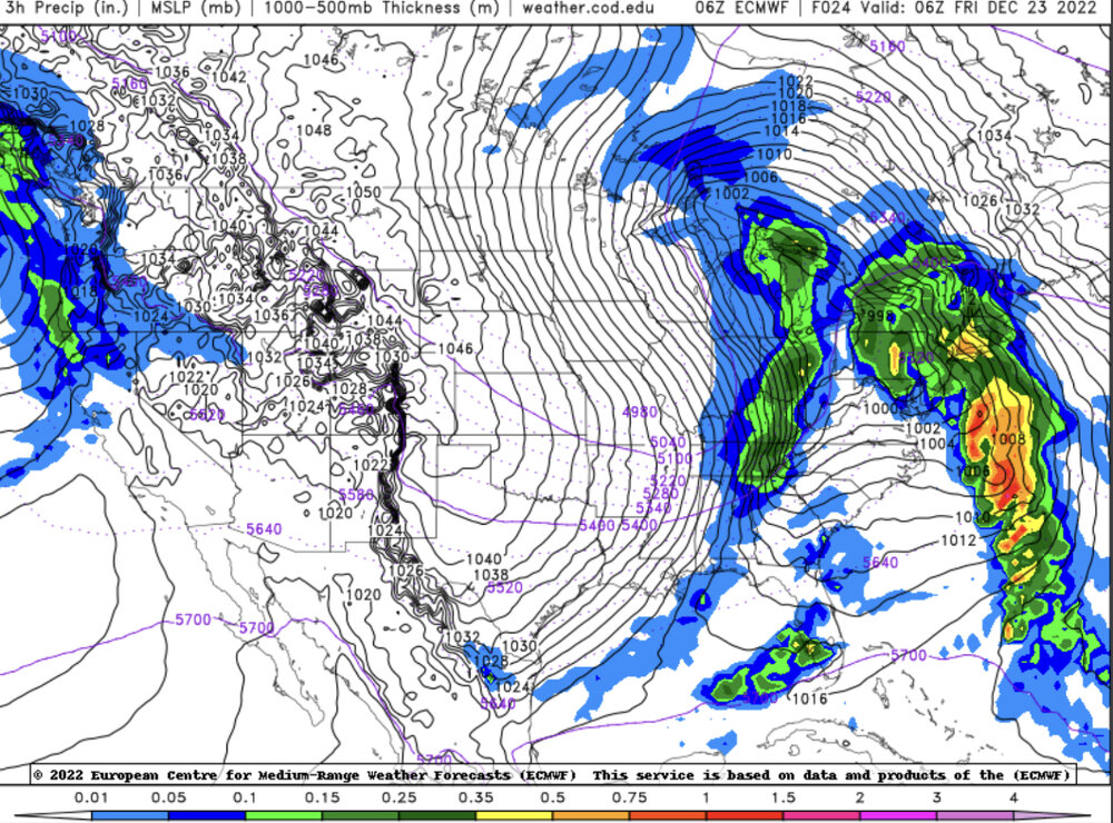
I know most models show very minimal snowfall amounts over the E TN valley and they are probably right because the HRRR has been on top of this system. But, here is the 6z Euro with a very interesting resolution - roughly .3” QPF over the whole forum area with widespread 1.5/2 with up to 3.5/4 in spots in the valley, widespread. I will say the Euro has been the straggler with catching up to the cold temps and it might be in wonderland with this but at least worth mentioning…you can access the 6 and 18z Euro and its kutchera ratio snowfall accumulation on weather.cod.edu btw.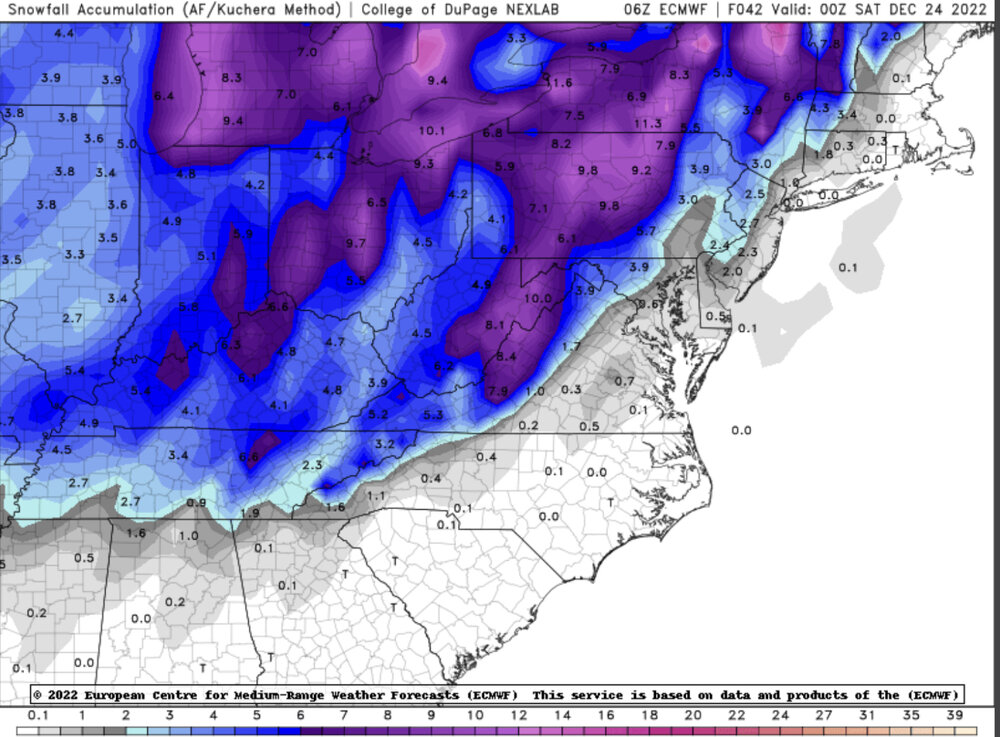
-
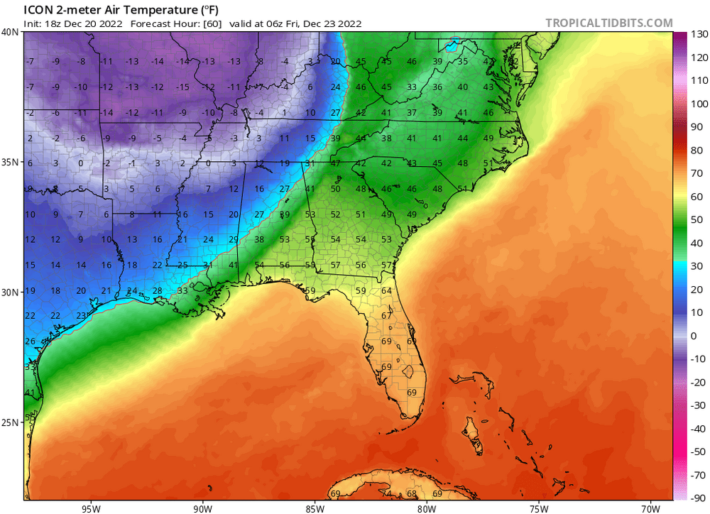
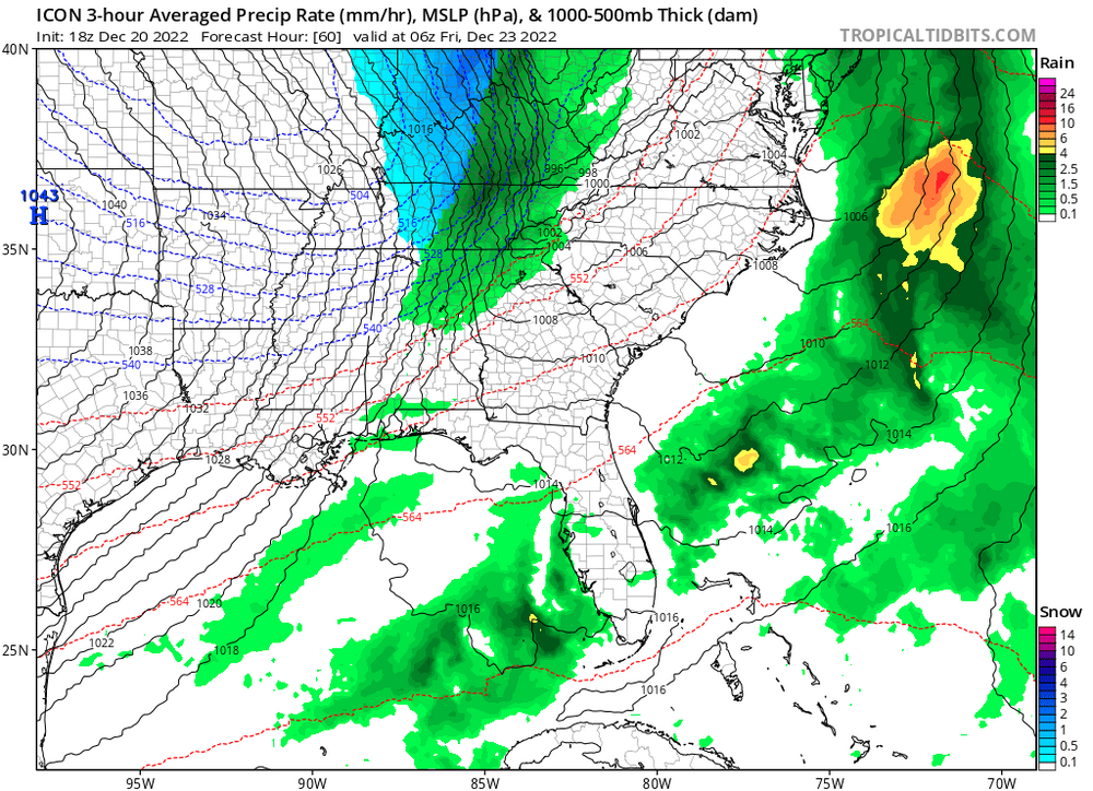
That’s odd the 32° 2-meter air temp line is 75 miles ahead of the r/s line on the Icon model for 1am on Friday. Lol what?
- 582 replies
-
- 3
-
-
- snow
- freezing rain
- (and 4 more)
-
Is it just me or does it seem like the -NAO has done more harm that good this year so far? I may be 18 years old but I’m old enough to remember the claim so many people say that a -NAO is good for the Mid-Atlantic and Eastern Seaboard. It seems like the NAO, or at least the variation of it this year, has been detrimental for us in the South and East. The massive low 500 miles ESE of Nova Scotia caused by the negative NAO has caused buckling in the jet further back west, over us, with only mediocre heights and a subtle upper ridge nudging and grudging it’s way over us again and again. Sure, Europe has definitely seen the cold and snow and it might just be the unfavorable Pacific; but, for us here in the East this massive -NAO has done nothing but churn higher 500 mb heights up into it along the Eastern Seaboard and that looks to be the case with the 22/23 system with basically a repeat of Dec 15 in the East, just colder this time. You might think I’m a clown(emoji here) but what the **** is wrong with this -NAO?
-
The GEFS and latest GFS runs want to keep next week’s trough hanging back in the western United States. Really quite remarkable; as Carvers likes to say the word, a “coup” is forming between the models. The Canadian, European, and both of their ensembles want to keep the “bowling ball” rolling across the lower 48 by Wednesday of next week which would ultimately allow an ULL to drop deeply into the southeast and mid atlantic, drawing down very cold air, mountain & maybe plateau snow by late next week into the weekend. This ULL, with enough assumed forcing and moisture inflow from the Atlantic, could create a pretty gnarly wrapped up snowstorm for New England and the Northeast Atlantic Corridor by next weekend. That’s one resolution, and the Canadian and European are betting on that right now. However, I beg to differ. If we recall, there have been a few systems noted by global models to be big snow makers that never came to fruition at all because of how the primary trough hasn’t been in its prime location(eg, -PNA trough & 50/50 low only mean one thing for sure…and that’s plenty of cold to folks living far out in the western US and a reduced risk for any impactful Midwestern, Ohio Valley, Mid - Atlantic, or Southeastern Snowstorms). We thought the arrival of major cold would be Dec 9/10 several days ago. Instead, we have seen a weak but very persistent southern ridge allow mild air to surge north, with the western US states being very cold and the far northeastern United States remaining quite chilly, because of the concrete 50/50 low hanging out up there. Like I’ve said, the Euro and Canadian show next week’s upcoming system effectively undercutting the blocking and negative NAO with a really impressive ULL stationed over the Ohio Valley along with East TN valley flurry and mountain snow activity. Instead of the system becoming a fully autonomous upper level cyclone like that, latest GFS and GEFS trends want most of the ULL itself to stay in the Northern Great Plains, Pacific Northwest and Western US as a whole, with only a weak exchange of lower height anomalies being *transferred* across the central US and Mid-Atlantic, with less deep cold here and no New Eng or App Storm. The front would still come through with rain nevertheless, but much of the cold and upper level low pressure activity and lower thickness levels would remain across the western United States with a very suppressed storm that spins its way to death out to sea in the Atlantic, just as the latest 18z Dec 9 & 00z Dec 10 GFS show. Despite the fact that the GFS changes with almost every run in a mind boggling and fundamental way and as a result many don’t put their trust in the GFS, I have come to find that it and its ensemble suite lead the way and are the first to sniff out trends in the modeling. I like to think of the GFS as a bipolar leader of a group of people. It seems to have no idea where it’s going and changes its mind a lot but is still ultimately the real leader of the group (all of the modeling), picking up on the realistic and true changes before every other model follows behind. Even though the Euro and CMC and their ensembles want the bowling ball to effectively spin deep and by itself across our part of the US by late next week, I think the GFS is onto something with the -PNA persisting and the ULL not undercutting the block very much but only simply transferring weak lower height anomalies and pretty wimpy cold(although a pretty big change to what we’re seeing now) to the East which is very much unlike recent Canadian and European runs. Over the next few days I expect the Euro, Canadian, their ensembles, and all other models to gradually wake up to where their bipolar leader is leading them and will look pretty similar to what the Dec 10th 00z GFS and Dec 10th 00z GEFS looks like through hour 192(December 18th.)
- 582 replies
-
- 1
-
-
- snow
- freezing rain
- (and 4 more)
-
Thank you. This is so helpful, interesting, and insightful. That’s cool you found a study stating that tendency/correlation. What study was it and who conducted it?
-
The latest Canadian Climate Model’s Forecast for December: -really nice -NAO signature with undercutting jet truly quite impressive to see so many models in unilateral agreement in regards to the prospect of a -Nao. Doesn’t mean we can count on it because the models haven’t been the best recently, but definitely a good signal for winter wx ❤️‘s!!!

- 582 replies
-
- 2
-
-
- snow
- freezing rain
- (and 4 more)
-
Hi, can you explain or elaborate more on why this is? Why does water vapor being pumped into the upper atmospheric cause cooling and what is the cause and effect relationship that exists in terms of the volcanic event promoting blocking on the other end of the pole(the northern hemisphere)? I’m not super keen on these kind of occurrences. Thanks in advance.
-
To Carvers Gap: Thank you very much for your well-informed thoughts and analysis. Your explanation helped to illustrate the circumstances that support necessary confluence and the importance of the NAO. I am 17 years old and enjoy studying the weather but don't have close to the experience and knowledge you all have. Thank you very much for your insight!
-
I have a question…perhaps some of you smart weather needs and geeks on here could provide some insight. During the winter, are there any key atmospheric features(things like teleconnections, MJO, storm timing, ULL’s, SLL’s, trough tilt) that have a strong effect and influence on whether southern stream storm systems “phase” with the northern cold upper jet to create significant snow storms? In other words, are there any deeper answers to why the pattern doesn’t work out for some(even those in the south) because of suppression other than blaming a “strong -AO”?
-
Latest NAM looking a little better at hour 51. Northern and southern stream vort/energy not as disconnected. Perhaps the ULL will try to scoop up more energy than the models are saying now. If that doesn't happen only coastal nc would see snow.
-
It seems like the overall trend is headed to the hrrr outcome with less precip over Nw and middle Tn, western ky and looks very similar to the Rgem at the end frames of the 18z hrrr
-
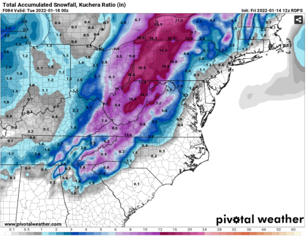
The Hi-Res CMC, or RGEM, is a fairly respectable and somewhat reliable model its outcome is halfway decent for the valley, particularly along and north of I-40, I 81 and up through TYS... RGEM Kutchera Output:
-
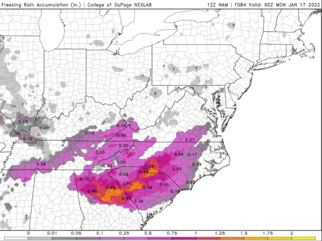
Like some were thinking the NAM may not check out with the thermodynamic profile for the NE TN valley but here is the ice map for those interested... What seems more likely and will probably make the ''weather disaster news headlines'' is .5''-1'' of solid ice over GA and SC urban centers like Atlanta if the cold air is robust enough.
-
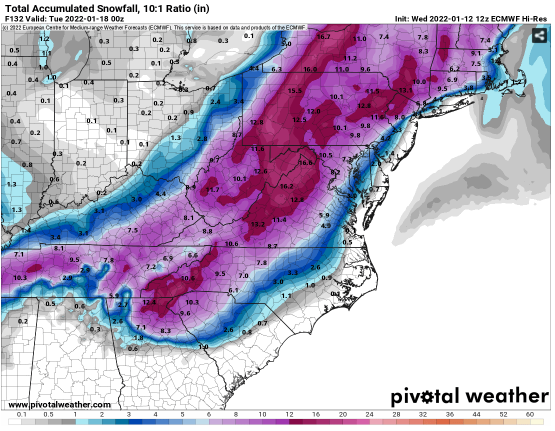
Here is just about snowfall from the entire storm. We get so caught up in these winter storms and it's easy to get fooled with how terrible the models have been doing but imagine it's winter in Jan 2017, 2018, 2019, or 2020 and someone showed us the Euro's exact 12z weather map. I think we'd go nuts over it. Models have gotten worse and maybe when the threat of winter storms move in we are so caught up in the models we forget how we long for snow around thanksgiving every year lol.
-
Synoptically the Euro honestly looks somewhat like the GEFS midday run
-
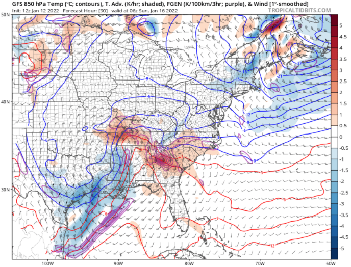
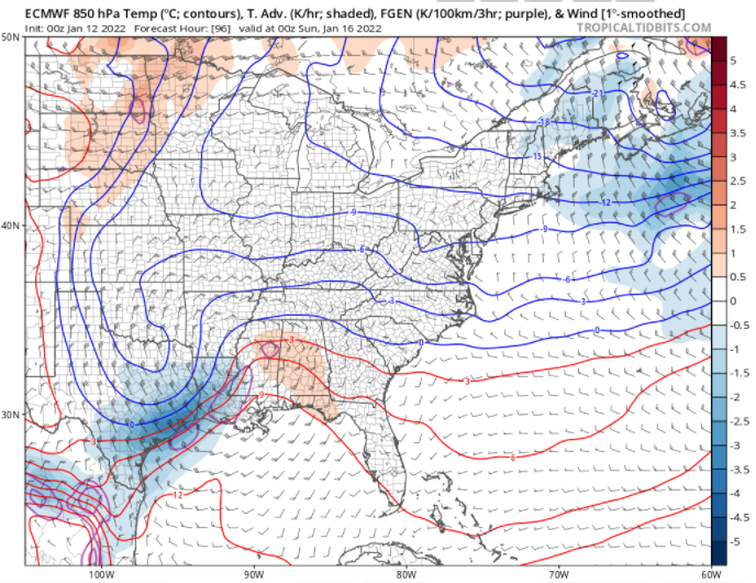
In everyone's experience with modelling on here, has anyone noticed if the GFS or Euro handle Upper Level Lows better? If the GFS is incorrect with the northwest trend, it will probably be due to poor handling with the ULL while better handling of the ULL may allow the Euro to come to fruition. Most of middle and East TN don't see much snow on the 12z GFS because it has the ULL slowing down and getting momentarily stuck over western KY allowing WAA over N AL and MIDDLE TN. If the GFS is known to handle ULL's well, then this may be a plausible outcome however it may also be possible that the GFS isn't phasing the ULL enough to reality like the Euro is suggesting. The fate of the storm may lie in the nature of the ULL. Here are the key differences between the 12z gfs and 00z euro...