
EastTNWeatherAdmirer
-
Posts
45 -
Joined
-
Last visited
Content Type
Profiles
Blogs
Forums
American Weather
Media Demo
Store
Gallery
Everything posted by EastTNWeatherAdmirer
-
I think I'm just gonna put all these silly models aside and go with the CFS. It is really good in the short-range. *sarcasm*
-
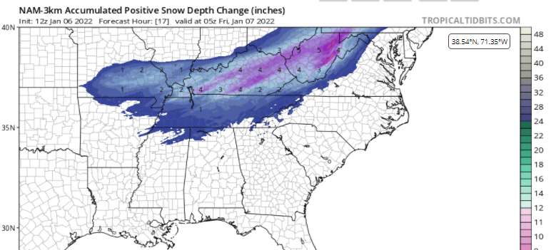
One thing that might be helpful in tracking this next system when questioning how far the precipitation shield sets up northwest and where the surface low goes is: remembering what models nailed the last system on January 6th. When tracking the January 5th/6th storm I remember the SREF model blend caught the trend over KY and WV the earliest and consequently some of the NAM runs followed. With this upcoming event, I like what I am seeing on the SREF if u want snow in East Tn. While it doesn't go out far enough to know for sure, on the SREF the snow rapidly diminished over far western Tennessee and Arkansas at the ends of its period. This implies that a transfer of energy and a secondary low would be developing near the gulf coast. I expect the NAM to come on board with the Euro at some point over the next 24 hours.
-
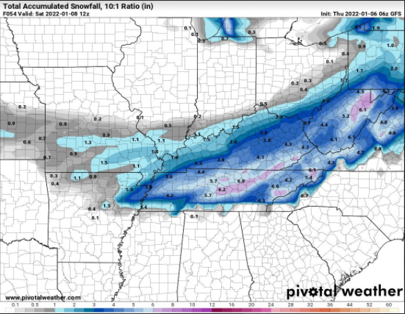
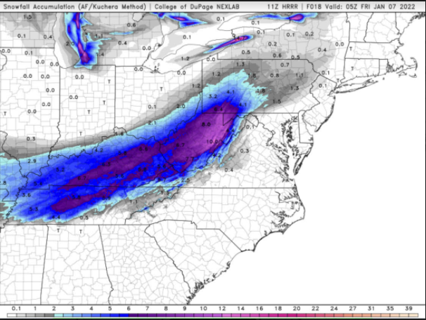
It was really the HRRR, Nam 3km, SREF(blend), and a couple of RAP runs that really nailed this one with the SREF really catching the extent of the snow to the Northwest. Credit goes to the Nam and HRRR for catching the warm nose and the undermining of dry air(nam3km) beginning over the southern plateau. HRRR 11z Thursday Kutchera snowfall was the ultimate and overall winner. Merit hasn’t been lost in the other models for short range, however. This was a really unique event with an especially difficult setup for the valley. Perhaps sometimes in the past you have seen the exact opposite happen: with the HRRR and Nam3km showing a drier and warmer profile than reality with precip and cold winning the battle. Perhaps the Nam 3km isn’t the most intelligent model overall, just in this case. It was just it’s nature to catch a warm frontal sector of air and that’s what happened. I think terrain over the plateau, SE Ky Mtns, and SW VA Virginia Mtns and the smoky mountains may have had something to do with this outcome. This also may have something to do with the idea of the storm's fast movement trumping the forcing, as MRX pointed out. If the entire southeast US was flat, I think most East TN wouldn’t have seen the 4-7 KY saw but instead may have seen a widespread 2”-3.5.” The smoky mountains funneled warm and dry air advection north which in turn allowed a broader surface low to propagate slightly further north and east than expected. The plateau and Cumberland Gap Mtns enhanced the temp and dry air gradient with, generally, those to the north of the SW VA, SE KY line seeing a fully saturated column with suitably cold temperatures which also enhanced rates and total accumulations.
-
Jan 6th-7th 2022 Second Chance Storm
EastTNWeatherAdmirer replied to John1122's topic in Tennessee Valley
It appears a big time BUST could be in store for the East TN central valley and tri cities unlike the GFS, RGEM, CMC, Euro, some NAM runs, WRF's, showed only a short time ago. Latest NAM km, HRRR probably pretty on track with 1''-2.5'' for Maryville, East Knox, Jefferson City, Blaine, Morristown up through Greeneville and Johnson City. Warm nose really overperforming with rain to start at first for most in the central and NE valley. Wrap around moisture could provide a light dusting of an inch overnight. This is one of the most difficult systems I've ever seen. Really sad day for those in East tn who wanted snow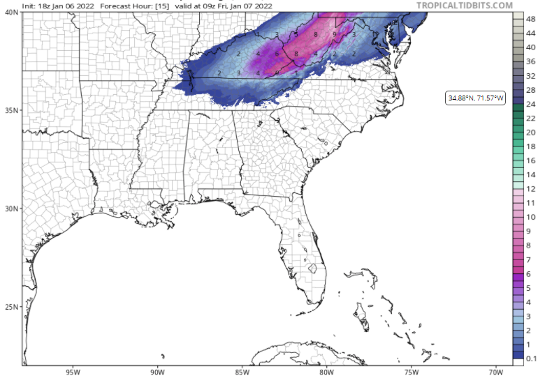
-
Morristown now up to around 2''
-
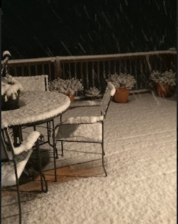
Flakes are about Nickel size now but absolute gangbusters with the rates and intensity. Reduced visibility, Roads are now completely snow covered at least on the south side of Hamblen County. Up to around 2” and going up fast
-
Rates really, really picking up now nicely over Hamblen county, probably .75''-1'' in/hr rn. About 1/4''-1/2'' on deck within minutes. Flake size has slightly decreased to penny size but intensity is considerable. Temp 33.4. From radar it appears the surface low is tilting even more negatively than expected, this suggests East TN will try to hang onto these bands for a bit as moisture is pumped north. Also the ULL feature near Chat could back build once it hits the mountains, and could create a wave, just a thought at this time though if low insists on getting out of here to the west fast.
-
All snow now in Morristown as the temp continues to fall. Nickel to Quarter sized flakes, 34 degrees.
-
Now about 90%-95% + snow here near Morristown. I don't have access to radar scope on my computer but if you look on the app under correlation coefficient it's pretty cool to see the change-over happen for most of west greene, cocke, and hamblen counties in which the outlying ''clutter-color'' on the map disappears and becomes uniform with the surrounding areas. If you haven't seen a changeover yet look for trends in the correlation coefficient. Nickle to Quarter sized flakes starting to lay on deck within minutes; slakes so big and rates heavy enough that significant melting isn't occurring, at least on the elevated surfaces. Temp now down to 34.5, will post the graph again next.
-
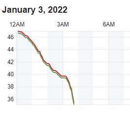
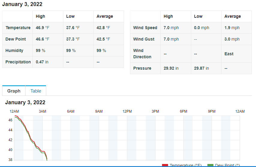
Just hit 38 degrees in Southeast Hamblen County near Morristown and big flakes starting to mix in now. Probably 40%-50% snow now, gradually becoming more mixed. Here is some data from my sensor, just like Carvers Gap said, ''when the temp hit 38, things start to change''. Temp is now taking a nosedive on the graph.
-
Jan 2021 Squallicane
EastTNWeatherAdmirer replied to Holston_River_Rambler's topic in Tennessee Valley
ABSOLUTELY INSANE VELOCITY RETURNS WITH CONVECTIVE BANDS OF SNOW MOVING THROUGH NE KNOX COUNTY. ANYONE KNOW HOW BAD THE DAMAGE IS???!!! #UNBELIEVABLE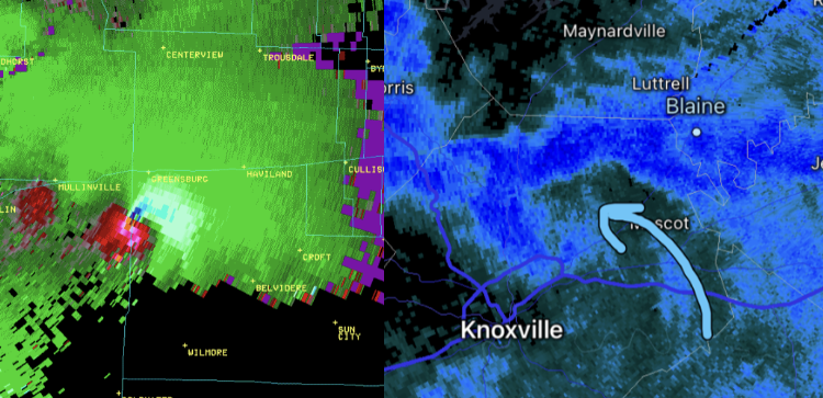
-
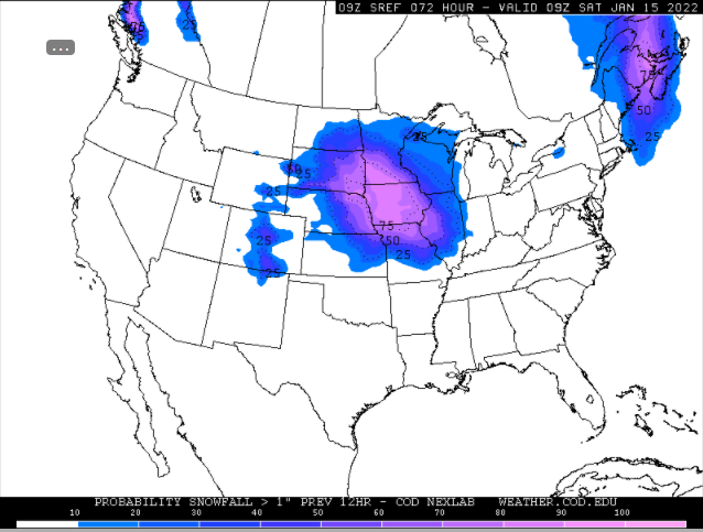
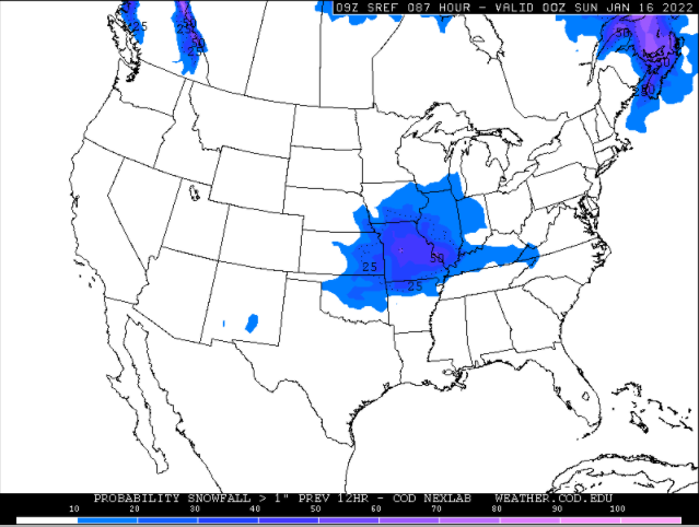
Hey I’ve been looking for the SREF all over. I think the SREF probabilities on weather.cod.edu may be a little delayed and such. Where do you get your from? Perhaps you could post a link. Thanks
- 847 replies
-
- 1
-

-
- cold temperatures
- snow
- (and 8 more)


