

JakkelWx
-
Posts
3,380 -
Joined
-
Last visited
Content Type
Profiles
Blogs
Forums
American Weather
Media Demo
Store
Gallery
Everything posted by JakkelWx
-
-
Another reason not to get ahead of ourselves.. I recently read a tweet stating how warm Nov = warm winter and cold Nov = cold winter. What really matters is the upper hemispheric pattern teleconnections for the winter. A cold Nov means nothing if the ensuing pattern after the fact is garbage. There isn't much correlation IMO.
-
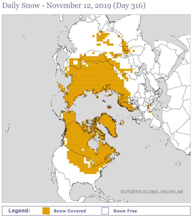
Snow cover continues to advance at record levels. Some relaxation in the extent is likely as the pattern turns milder.
-
Euro model has a strong trough moving through the region around the D9 timeframe but not quite the look I'm looking for if we want decent wintry precip. Ridge a little too strong in the NW and not quite in the most favorable spot, and the SW over California will have a tough time transferring energy to the trough in the east in that location. In general I think late Nov - early December timeframe will have multiple opportunities after the pattern shuffle warm up.
-
BAMWX supports the idea of a trend to colder than normal risks for December. What is interesting is the ridge in the SW US. That would signify a weakening of the STJ. EPS showing the idea of a -NAO developing just in time for Thanksgiving. Should be fun.
-
Yeah don't take their forecast to heart, especially recently with the bad model runs for December about a week ago. Now the disaster torch that was advertised over the past couple of weeks seem to be getting pushed back and now it isn't so much a torch now but just generally mild, so I see how they have a higher confidence for BN vs AN. I have noticed that it may end up being the opposite of last year when the long range seasonal/monthly models kept on kicking the can down the road for a NAO block of all blocks that never actually happened until it was too late. The models this year may end up pushing the unfavorable setups back and we could end up averaging a legit -NAO for the winter.
-
BAMWX surprisingly coming up with a BN December.
-
I hated that dry slot. We stopped at like 13 inches before it sleeted, then a couple inches on the backside. The dry slot caused it to start sleeting because we were too close to the r/s line plus the rates weren't high enough.
-
Mid-Atlantic winter 2019-20 snowfall contest
JakkelWx replied to PrinceFrederickWx's topic in Mid Atlantic
BWI 43.6'' DCA 38.7'' IAD 39.2'' RIC 17.1'' SBY 24.5'' -
I predict no snow from April through November next year.
-
5th grade. 2001. I remember that day as a normal day in class talking about the hurricane (Erin I think?) as I was a huge weather nerd. Suddenly the teachers announced the news that planes hijacked by terrorists have been crashed into both world trade centers. Honestly thought we were entering a war during that period. We had to leave schools early due to safety concerns and being near Washington D.C, as the elementary school I went to was only about 20-30 miles from there. #NeverForget
-
-
Damn. Ninja'd again before I was gonna post Josh's latest tweet:
-
Yeah, cat 1 with sustained gusts of over 185 mph. Devastating to say the least.
-
Sorry my question was meant to be sarcastic. Apologies.
-
Also, how does a mod get hired on the forums? I'm looking to become one.
-
what is going on in this thread
-
Almost 14 hours straight of tracking dorian now. Safe to say I've beat my personal record of about 11 hours or so tracking Irene moving up the coast after I graduated high school.
-
Is it still wobbling WSW?
-
Honestly I've been staring at the satellite and models ya know for hours on end without budging since yesterday morning. It's like a NHC shift but at home and i'm not even qualified lol. But I could qualify since I'm good at sitting at the edge of my bed tracking hurricanes for so long.
-
Cmon guys. Really? SW Wobble. Yes, SW wobble. You heard it right. SW wobble! We talkin' bout SW wobbles. How many SW wobbles will it take to will this thing to Australia?
-
18z GFS is the same at hour 0 as it was through hour 6 at 12z.
-
How much for cancun?
-
I see a WSW wobble on radar.
-
At this rate of intensification Dorian will be a 300 mph sub 850 mb storm by tomorrow morning.


