JakkelWx
-
Posts
3,393 -
Joined
-
Last visited
Content Type
Profiles
Blogs
Forums
American Weather
Media Demo
Store
Gallery
Everything posted by JakkelWx
-
We're in a good spot. Roughly 0.5 - 0.6'' of QPF to my yard with over an inch just to my south. One more shift north and I'm in the really good goods.
-
Just need Mt. Holly to cooperate.. lol
-
till april ftw
-
Eastern MD near CAPE.. in Goldsboro
-
I have returned from grotto's pizza. Looks like 12z models look just a little better than 06z. Based on short-term models and trends, NWS Mt Holly could use a little constructive criticism for hedging a little low on snow totals, at least for the central (where I am) and the southern areas. Northern areas could use a little tweaking with the snow maps as well.
-
My clouds now are even cloudier than the clouds from an hour ago, which were cloudier than the ones from the hour before. It's almost game time. Currently a temperature of 34 with a DP of only 14. Once onset occurs, temps will drop and dewpoints will rise here
-
DC is squarely in the 0.5'' QPF, unlike 06z. Precip across all of the area is an improvement from both 00z and 06z, respectively.
-
12 GFS seems less strung out than 06z by a little. Meanwhile there are some good radar returns in SWVA moving NE.
-
My clouds are starting to get cloudier
-
That's 06z
-
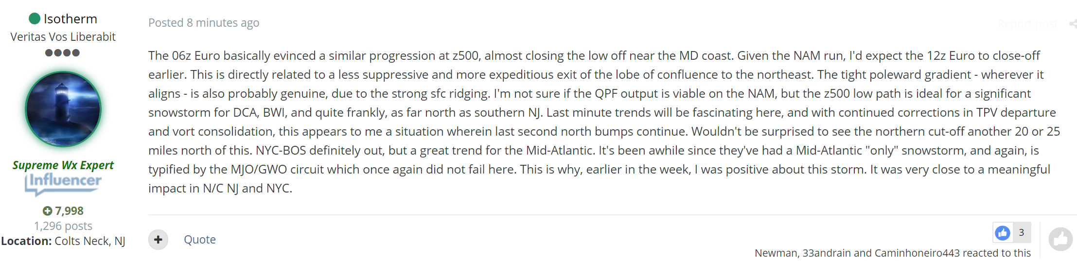
From @Isotherm on 33andrain... Good write up explaining the Z500 vort, low path trends and QPF.
-
Onto current OBS... Radar returns are just now reaching Chicago with a side of radar hallucinations.
-
-
NAM doing NAM things.
-
lol the NAM radar is juiced
-
You aren't wrong... I mean by the looks of current radar OBS, the precip shield is almost to northern Iowa.
-
Hmm... 4-6'' seems like a good call for my house now based on the overnight trends north. If 12z holds north, I'll lock it in..
-
Pretty, red sky this morning. Sailors take warning.
-
21F/DP 17 with a very small hint of daylight just showing up to my east. Perfect winter morning just before a snowstorm.
-
00z NAM is a little farther north again out to 14 hours. 12KM
-
Any concerns for moon angle?
-
Temp 27/DP 14 here and sipping a Bailey's hot chocolate. I have my heater on which is producing a white-noise like sound.
-
Current modelled ice thickness by the Danish Meteorological Institute. July 23. Notice that really thick ice in Baffin island.. Has that always been there?