
brianc33710
-
Posts
281 -
Joined
-
Last visited
Content Type
Profiles
Blogs
Forums
American Weather
Media Demo
Store
Gallery
Everything posted by brianc33710
-
This is the Mayfield, KY courthouse as it stands tonight. Below this is its original appearance.
-
Its worth investigating along the whole track. The Tuscaloosa-Birmingham supercell in April 2011 looked to be close to 200 mi at 1 point. However, once investigated, the tornado showed it briefly cycled between Tarrant & Center Point, on the N-NE side of Birmingham. My Dad & Aunts live(d) within the very narrow window where the twister very briefly lifted before producing another EF-4 as it got to Center Point. Had that tornado not lifted they wouldnt still be here.
-
Have there been reports of debris falling from the sky in advance of these storms? I know that this happens, but being at night we may not know this.
-
Leachville Dollar General per this guy.
-
Tyler M @PA_Tropicswx · 16m A report from mayfield- All official emergency broadcast transmitters just went dead. This is catastrophic.
-
The cell kicked up a debris ball as it tracked thru Mayfield.
-
I spent a lot of time & had a lot of fun with friends who loved on the west side of the New Orleans metro -- Destrehan, Norco & LaPlace etc. My buddy from there now lives closer to Jacksonville, FL but he says he still has family that didn't/couldn't evacuate. I pray they are all OK.
-
Here's the lowest pressure I've found on the NWS page Galliano, South Lafourche Airport 28.33 14:15 Galliano, South Lafourche Airport28.33
-
Lake Charles device recorded 90 mph & gusts 130 before breaking. As another note, I didnt sign in last night b/c Ida couldnt get back to CAT 3. I woke up & shes at 150 mph! Of note, given the swampy nature of the land Ida wont weaken for a while.
-
MOD Risk & PDS STW but TWC still airs programs? Are they at least giving top & bottom hr updates? Admittedly PDS STW is quite rare, but a MOD Risk this time of year definitely deserves attention. EDIT They're not even giving 30 min updates!
-
I still have my Pinellas Co phone# but didnt get any alerts on it. But I live in landlocked Birmingham now.
-
Pressure dropped 1007 to 1000 mb, still high given 70 mph winds but significant drop given Elsa's BP history.
-

Severe heat wave June 2021 in the southwest -- PSP 123F
brianc33710 replied to Roger Smith's topic in Central/Western States
Seattle's forecast high for Monday (28 June) 108-110F/42-43C, is hotter than Birmingham's top temperature ever, 107F/41.5C. So far we've been stuck in a wet & below normal temps rut this summer. Hopefully the pattern changes sooner than later. I love the heat & humidity and not afraid to admit it! -
If someone else has started this feel free to delete this. I only see this topic in TN Valley & South-Central states. SPC AC 041629 Day 1 Convective Outlook NWS Storm Prediction Center Norman OK 1129 AM CDT Tue May 04 2021 Valid 041630Z - 051200Z ...THERE IS A MODERATE RISK OF SEVERE THUNDERSTORMS CENTRAL/SOUTHERN MS TO WEST-CENTRAL/SOUTHWEST AL... ...THERE IS A SLIGHT RISK OF SEVERE THUNDERSTORMS MID-ATLANTIC STATES... ...SUMMARY... Numerous to widespread damaging winds and a few tornadoes are expected through this evening across the Deep South. ...TX to the Southeast... Complex forecast this afternoon into the evening with several clusters of ongoing convection from southeast TX to the southern Appalachians. A moist and moderate to strongly unstable air mass exists across a broad region ahead of this activity. As noted in 12Z regional observed soundings, this is where an elevated mixed layer/plume of steep mid-level lapse rates is established atop rich boundary layer moisture with surface dew points in the low 70s that precedes an eastward-moving cold front located near the ArkLaTex and southeast Texas. Influenced by the progressive southern stream shortwave trough, storms should expand in coverage/intensity this afternoon with a corresponding uptick in wind damage potential expected aside from a persistent severe hail risk. Strengthening belt of southwesterly low/mid-tropospheric winds will support organized storms including growth into multiple quasi-linear MCSs. Widespread damaging winds, some significant, and brief tornadoes will be possible with the primary QLCS that is expected to evolve across the Lower MS Valley into AL. ...Mid-Atlantic States... With a portion of the elevated mixed-layer present across parts of the region as sampled by the 12Z GSO/RNK soundings, destabilization will be pronounced today as nearly full insolation is occurring east of the Appalachians. An MCV will probably emanate east-northeast out of an MCS that has weakened over the southern Appalachians. The net result should be the potential for scattered damaging winds from strong to isolated severe gusts as multicell clusters spread towards the Mid-Atlantic Coast. ...Mid-South to Lower OH Valley... Partial clearing is underway ahead of the mid-level shortwave trough over the Ozarks. This should contribute to sufficient recovery for a threat of isolated to scattered large hail and damaging winds downstream of this trough, along the eastward-moving cold front. ..Grams/Moore.. 05/04/2021 CLICK TO GET WUUS01 PTSDY1 PRODUCT NOTE: THE NEXT DAY 1 OUTLOOK IS SCHEDULED BY 2000Z CURRENT UTC TIME: 1816Z (1:16PM), RELOAD THIS PAGE TO UPDATE THE TIME Top/Latest Day 2 Outlook/Today's Outlooks/Forecast Products/Home
-
Historic Tornado Outbreak April 27, 2011
brianc33710 replied to CUmet's topic in Weather Forecasting and Discussion
I don't know if anyone else plans to post anything in here, as tomorrow marks the April 27 2011 Superoutbreak's 10th anniversary. But the Birmingham & Huntsville NWS put this together. https://04272011-noaa.hub.arcgis.com/ I'm sure some others out there have things to add & share. -
New Watch Severe Thunderstorm Watch SEVERE THUNDERSTORM WATCH OUTLINE UPDATE FOR WS 110 NWS STORM PREDICTION CENTER NORMAN OK 455 PM CDT SAT APR 24 2021 SEVERE THUNDERSTORM WATCH 110 IS IN EFFECT UNTIL 900 PM CDT FOR THE FOLLOWING LOCATIONS ALC007-009-015-017-019-021-027-029-037-049-055-071-073-089-095- 111-115-117-121-123-125-250200- /O.NEW.KWNS.SV.A.0110.210424T2155Z-210425T0200Z/ AL . ALABAMA COUNTIES INCLUDED ARE BIBB BLOUNT CALHOUN CHAMBERS CHEROKEE CHILTON CLAY CLEBURNE COOSA DEKALB ETOWAH JACKSON JEFFERSON MADISON MARSHALL RANDOLPH SHELBY ST. CLAIR TALLADEGA TALLAPOOSA TUSCALOOSA $$
-
Yeah BMX just issued warning for SW Blount & NE Jefferson Cos. That includes me. Severe Thunderstorm Warning Severe Thunderstorm Warning ALC009-073-242200- /O.NEW.KBMX.SV.W.0067.210424T2135Z-210424T2200Z/ BULLETIN - IMMEDIATE BROADCAST REQUESTED Severe Thunderstorm Warning National Weather Service Birmingham AL 435 PM CDT Sat Apr 24 2021 The National Weather Service in Birmingham has issued a * Severe Thunderstorm Warning for... Southwestern Blount County in central Alabama... North central Jefferson County in central Alabama... * Until 500 PM CDT. * At 435 PM CDT, a severe thunderstorm was located near Arkadelphia, or 10 miles northeast of Sumiton, moving east at 50 mph. HAZARD...60 mph wind gusts and quarter size hail. SOURCE...Radar indicated. IMPACT...Hail damage to vehicles is expected. Expect wind damage to roofs, siding, and trees. * Locations impacted include... Dallas, Warrior, Kimberly, Locust Fork, Trafford, Hayden, Nectar, County Line, Blount Springs, Bangor, Arkadelphia, Smoke Rise, Remlap, Rickwood Caverns and Partridge Crossroads. PRECAUTIONARY/PREPAREDNESS ACTIONS... For your protection move to an interior room on the lowest floor of a building. && LAT...LON 3380 8657 3377 8658 3376 8696 3379 8697 3380 8695 3387 8696 3387 8692 3391 8692 3392 8689 3394 8688 3393 8686 3395 8684 3394 8682 3396 8682 3395 8679 3397 8677 3399 8676 3403 8670 3405 8671 3407 8669 TIME...MOT...LOC 2135Z 264DEG 42KT 3384 8689 HAIL...1.00IN WIND...60MPH $$ 75 Linhares
-
I find it odd that the BMX & SPC has Bham Enhanced when clearly the models show the best conditions well south of us.
-
BMX warned for golf ball size hail w/ our hi risk 25 Mar but tennis ball in slight risk today. BMX did warn for tennis ball moderate & high 17 Mar.
-
The newest updates drags the east edge of Ehanced to Tuscaloosa but still west of Birmingham.
-
I thought for sure the Brent to Wilsonville would at least get a low-end EF-4. But we did wind up with a really wide twister.
-
The SPC keeps the watch just north of Birmingham. Since Blount, Cullman & Walker are in the Slight risk and we're Marginal that makes sense. Hopefully we don't get bumped up overnight.
-
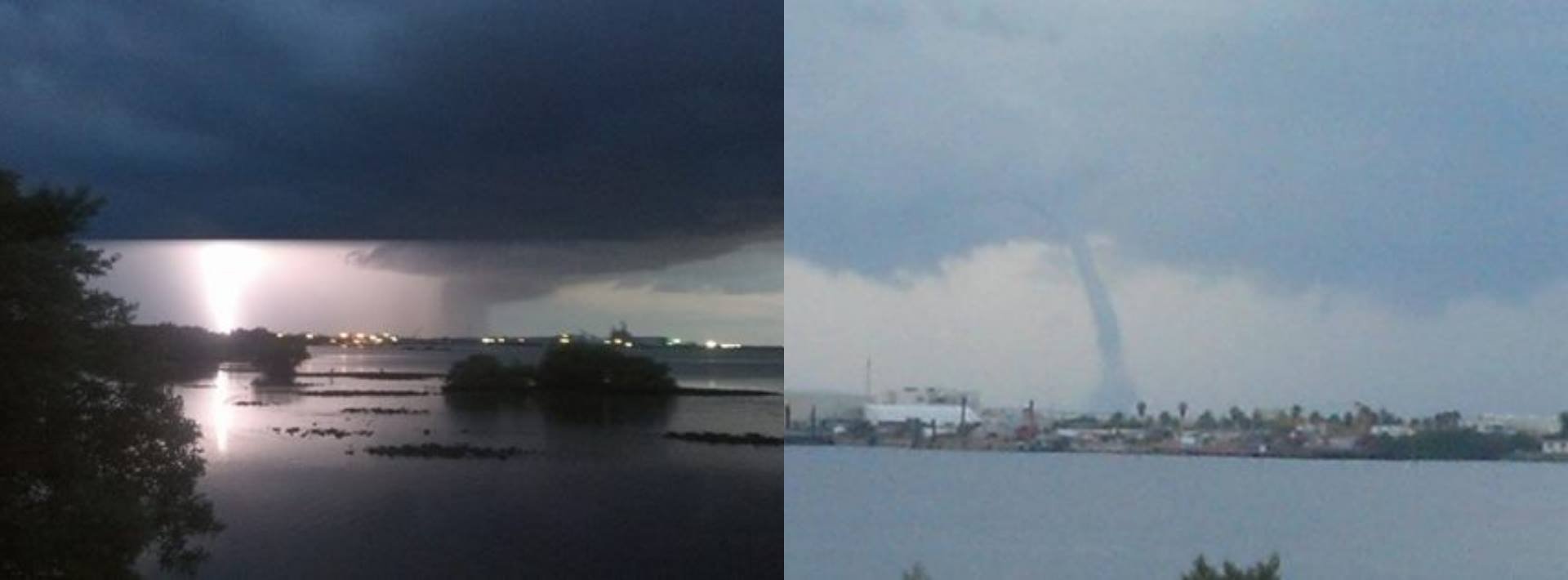
Here is Evan Hatch's photo from Lake Murvaul TX
-
Isnt 90 mph borderline PDS Severe Tstm Watch criteria? The IA derecho was PDS for 80-100, but they wound up with 140 mph.
-
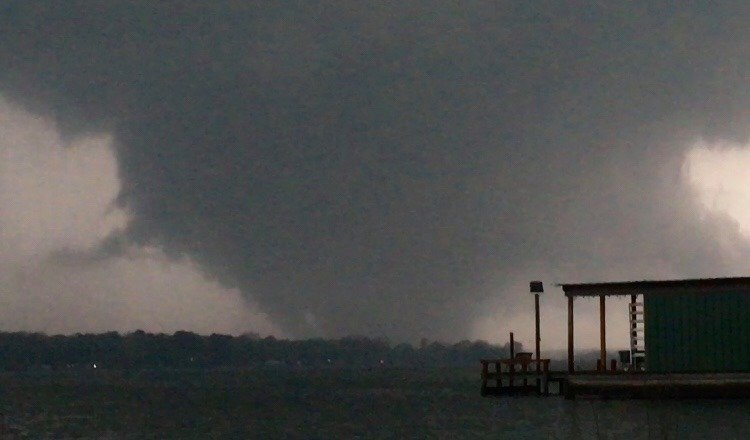
I would really like to get some sleep & the birds would rather not spend the night in their travel cages. So hopefully things settle down before reaching Cen AL. Bham is about 1/2 way between the slight & marginal borders so hopefully we can take the night off. But the Fultondale EF-3 was on a borderline marginal-slight night too. I dont know how to share it but Evan Hatch has a picture of the monster near Lake Murvaul TX on his FB feed .


