
brianc33710
-
Posts
281 -
Joined
-
Last visited
Content Type
Profiles
Blogs
Forums
American Weather
Media Demo
Store
Gallery
Everything posted by brianc33710
-

Historic Christmas Cold & maybe snow?! Dec 23rd-30th
brianc33710 replied to Wurbus's topic in Tennessee Valley
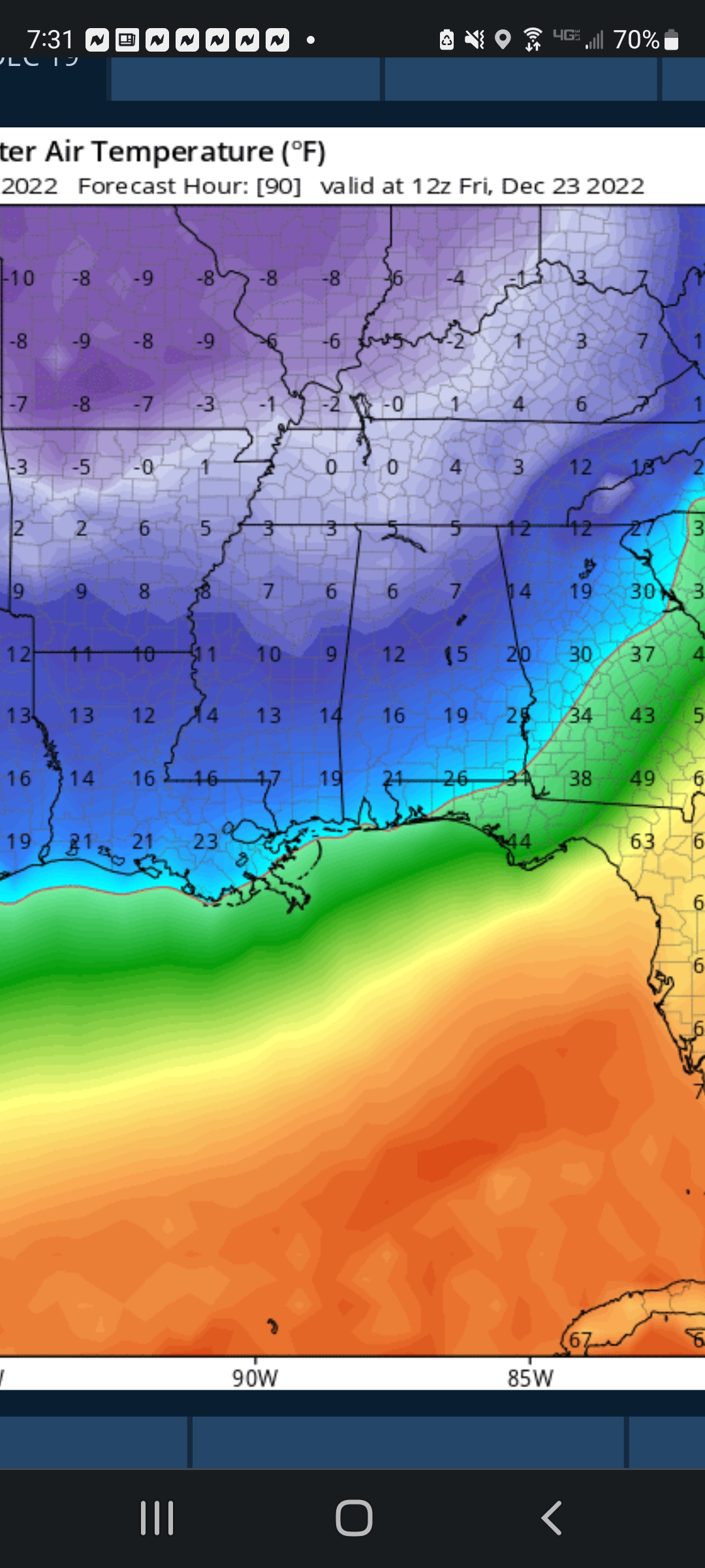
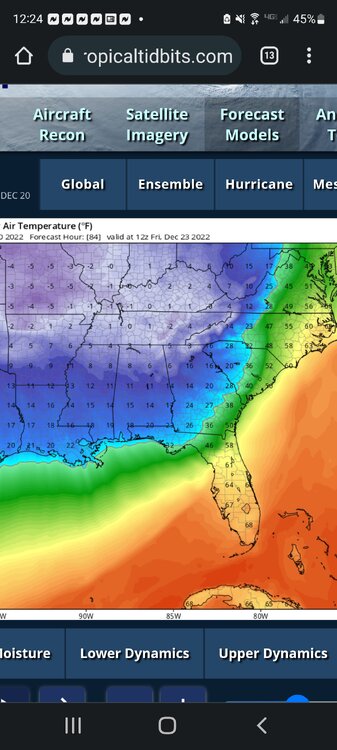
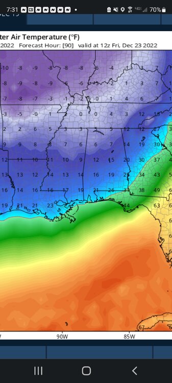
I know last night the CMC showed the area having sub 15F/-9.5C for nights on end. I started a feed in the SE forum. I couldn't find 1 so I started 1. -
I don't know if anyone has already started this. But parts of the SE US is forecast to experience its most brutal Arctic blast in 5-9 years, depending on the model. While they differ on the coldest morning, both the GFS (Fri am) & Euro (Sat am) forecast Birmingham to drop to 5-8 F/-15 to -13.5 C in this extreme cold event. The local guys are predicting 10-11 F/-12 to -11.5 C, but the models keep showing Temps under this.
-
The Tornado threat is fairly high. But SPC maps also significant severe winds & large hail don't appear to be expected today
-
Yes the SPC upgraded to a 4/5 about 1030. But the Fultondale, AL EF3 (Jan'21) & Nashville EF3 (Mar '20) formed in just upgraded to Slight Risk & the EF4 just east of Nashville formed in a Marginal Risk & 2% Tornado threat. So 3/5+ risks aren't needed for strong & even violent tornadoes.
-
11/29/22 MDT Outlook Issued -- Regional outbreak possible.
brianc33710 replied to CryHavoc's topic in Central/Western States
This thread looks dead too. -
Is this thread dead?
-
I'm working but trying to monitor things from Hoover, AL.
-
TDS Shelby Co but no lightning strikes anywhere in Cen AL.
-
Yeah that's bad!
-
We had a brief outbreak in central & west central AL & at least 1 appears was an EF2+ over Perry/Bibb/Shelby Co. But the situation down toward Mobile, which had 65+ dewpoints, still hasn't wound down.
-
The temps definitely warmed up with the very strong southerly winds but the dewpoints never increased. Last time they at least got close to 60 but today in Bham the temp briefly got to 55 before falling back to 52. Even right now with rain nearby its only 54. But I did hear that the low moisture content could make straight line winds worse than otherwise.
-
So Cen AL is in a "dry" dewpoints slot? They're higher east & west of here. I didn't know east GA & SC were 60+ too.
-
I'll remain bearish for areas near Birmingham. Last time stout SE gradient south winds brought warm air but the dewpoints barely cracked 60 in Tuscaloosa. SW flows bring in more moisture. Right now we're 74/51 & our flow is more SE than SW again. The warmth is there but not moisture & instability. Also as I've said before all of our threats since last March were at least somewhatdiminished by lingering convection that gave us very heavy rain. Eventually our "luck" will run out but I don't see that streak ending today/tonight. .
-
The NWS has 3 levels of severe tstm warns. I think we'll see the high ends that triggers EMA procedures today/tonight with 80+ mph winds.
-
I had thought the SPC would expand Moderate a little further east. I guess by now we know they won't go High today-tonight despite the very high straight line wind threats. Could/would the SPC issue a PDS Tornado Watch but for just the 80+ mph straight line winds & not tornadoes? I'm guessing no & the tornado threat is too high not to go with tornado not svr tstm.
-
Yeah that's my thinking. I don't think we'll get close to PDS Tornado Watch territory but the high-end straight line wind is definitely there. As an aside tonight was great timing for BMX's advanced Skywarn training given its only once per season.
-
Even if not High Risk, could this result in a PDS Severe Thunderstorm Watch situation? Or could/would the tornado threat still be too high for that? It appears the SPC issued PDS Tstm last July cause of 90 mph straight line winds but the tornado threat was lower then than now.
-
Could this resemble the AM (NOT PM) 27 April 2011 system over AL? That featured the derecho & embedded EF2-3s in the QLCS. Easter 2020 had EF2-3s in a QLCS line as well. Birmingham, AL has "benefited" from flooding rains that have worked to stabilize the atmosphere repeatedly since last March. But those also caused death & destruction. Notice I said AM NOT PM for 27 April 2011! Those were separate systems to an extent in AL & I don't want to include/confuse it with the "generational" event later that day!
-
How much of this area hit tonight was rebuilt after Katrina? Obviously if areas impacted had stricter building codes since 2005 this could be noteworthy.
-
BMX replaced TOR with Svr T'stm warn. Tuscaloosa Co Tor Watch also canceled.
-
OK. In reflection, having gone to LSU I should've remembered the distance. Im just a dumbass at times.
-
How far from Biloxi AFB was this tornado? Obviously you have most of the Hurricane Hunters there.
-
Tornado Watch is now in effect for most of W AL.
-
The SPC gave 3 potential inhibitors later today which is I assume why they've chosen to slightly enlarge Mod without going High. I guess if any of these become less of a development distractor the SPC could bump it up later today.