
brianc33710
-
Posts
281 -
Joined
-
Last visited
Content Type
Profiles
Blogs
Forums
American Weather
Media Demo
Store
Gallery
Everything posted by brianc33710
-
 That's in the center of the Day 2 Moderate Risk & Day 2 Mod Risks are impressive in their own right. I guess we'll see if SPC upgrades to High closer to Tue & expands the other zones. Tuscaloosa is in Enhanced but there's a rapid reduction to Marginal in Birmingham. They're not sure how far north the warmth & instability reaches. I'm sure we'll be the bullseye later in the season though.
 -
NCAA BB tourney too
-
March 11th-13th Winter Weather Event. Winter's last gasp?
brianc33710 replied to Windspeed's topic in Tennessee Valley
Have there been any freezing rain reports so far tonight? -
James Spann showed this map tonight. BMX has a red line w/ a 1 in the HWO for Thu. To me the weather doesnt look warm enough for a big outbreak. But things could change between now & Thu.
-
Had Cen AL not "benefitted" from flooding rains 17 & 25 March and then May 2021 we would've probably have had a much more serious severe weather outbreak than we actually had. Both March days did get bad with damaging tornadoes but convection worked over the area to the point that we stopped short of what most would consider "High Risk" events.
-
Here in NE Bham we finally have started to some sleet & snow mixing in with the rain.
-
I think that we've now set a precedent for all winter weather threats from here in Bham on out. From now on, strange atmospheric conditions will always place themselves over within a 30 mi radius while everyone around us gets snow but we just get a cold rain.
-
BMX added several counties further down to its WWA. Unfortunately I can't copy & paste the graphic and the screenshot photo is too large to share thru my phone.
-
Gotcha! So that would mean a foot of sleet that far south? Ill let this go as this isnt the thread for this. Thanks for clarifying that @AirNelson39 !
-
I was in Tampa Bay at that time. This could definitely surprise us. BUT actual air temps are 15-20 degrees what they were for Snomageddon 2014. For that we knew that the cold air was there but the moisture wasnt expected, Bham had never received accumulating snow at 19-20F (-7.5 to -7C) so we had 20:1 snow ratios. This time we have plenty of moisture but can the temps drop enough to make the precip stick?
-
Also, has anyone else noticed the snow/ice storm all the way down to the Gulf Coast GFS has forecast for the end of January? Obviously thats a ways off. BUT, this shows Baton Rouge & Savannah would get 17", Meridian 16", Biloxi/Gulfport 15" of snow lol. That would probably take a bitterly cold airmass to make this happen.
-
That's typically an almost ideal Low Pressure center for snowstorms in Cen AL. But obviously things can change.
-
Cen AL had a strong gradient Feb 21. Near the AL/MS state line got significant icing while Bham hovered 33-34 the whole time. As the system pulled out we saw some snow though. Admittedly the frigid air wasnt far west of us either.
-
When did this HRRR update? This map shows more snow in Cen AL than others Ive seen. More sleet too but the freezing rain still stays well E of Cen AL.
-
Huntsville NWS issued a Winter Storm Watch but just for DeKalb & Jackson Cos., not even a Winter Weather Adv for any other AL counties. But all their TN counties have a watch. They havent updated their graphics since 7:30 AM which was before adding DeKalb & Jackson to the watch.
-
Maybe we could/should lower the EF5 criteria from x>200 to x=200+. Having multiple EF4s exactly at 200 when its just 1 mph away from that upgrade makes 0 sense at best.
-
This was a bit further back in the thread, but I had used the 2011 Tuscaloosa-Birmingham Tornado as an example of a tornado thought to be on the ground 100s of miles only to find it very briefly cycled over NE Bham. Had it not cycled my Dad's & Aunts house would've been badly damaged if not completely destroyed. The twister lifted near Tarrant & dropped a new EF4 once the supercell reached Center Point.
-
Enhanced Severe risk and storms Dec 31,Jan1
brianc33710 replied to jaxjagman's topic in Tennessee Valley
And we're under a Winter Weather Advisory tonight. Its heavy snow in Tuscaloosa & 34 but rain & 51 in Birmingham. -
Enhanced Severe risk and storms Dec 31,Jan1
brianc33710 replied to jaxjagman's topic in Tennessee Valley
The time is now 12:16 CST. From what I can see Birmingham stayed above 70 all 24 hours NYD. I feel fairly certain we broke the record for warmest minimum temperature ever in meteorological winter! EDIT: Ive emailed BMX & James Spann but dont expect to hear back til the severe threat ends. -
Enhanced Severe risk and storms Dec 31,Jan1
brianc33710 replied to jaxjagman's topic in Tennessee Valley
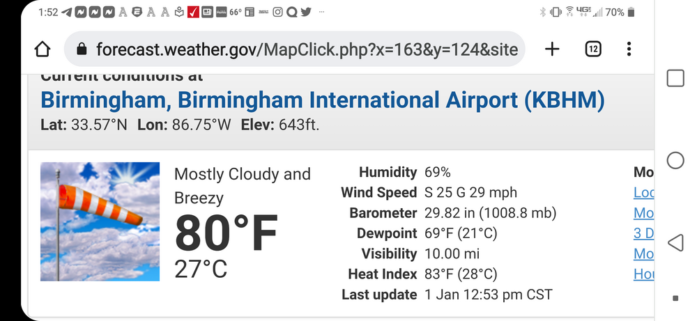
So far our low for Birmingham today is 71. There has never been a 24 hr min temp 70+ In meteorological winter in Bham. In December 1991 (my High School senior year) we had a 70/1 am low but dropped to 69 before midnite. So these temps in & of themselves amaze others out there & me. I guess we wait & see if the storms knock us back below 70 before midnite. -
Enhanced Severe risk and storms Dec 31,Jan1
brianc33710 replied to jaxjagman's topic in Tennessee Valley
Yeah SPC just issued a Tornado Watch for our area, Cen AL. -
Enhanced Severe risk and storms Dec 31,Jan1
brianc33710 replied to jaxjagman's topic in Tennessee Valley
-
Enhanced Severe risk and storms Dec 31,Jan1
brianc33710 replied to jaxjagman's topic in Tennessee Valley
Yeah lol! Now 80/69 in Bham! Bham Jan record 81 10 Jan 49. This is even above Key West NYD norms.
-
Enhanced Severe risk and storms Dec 31,Jan1
brianc33710 replied to jaxjagman's topic in Tennessee Valley
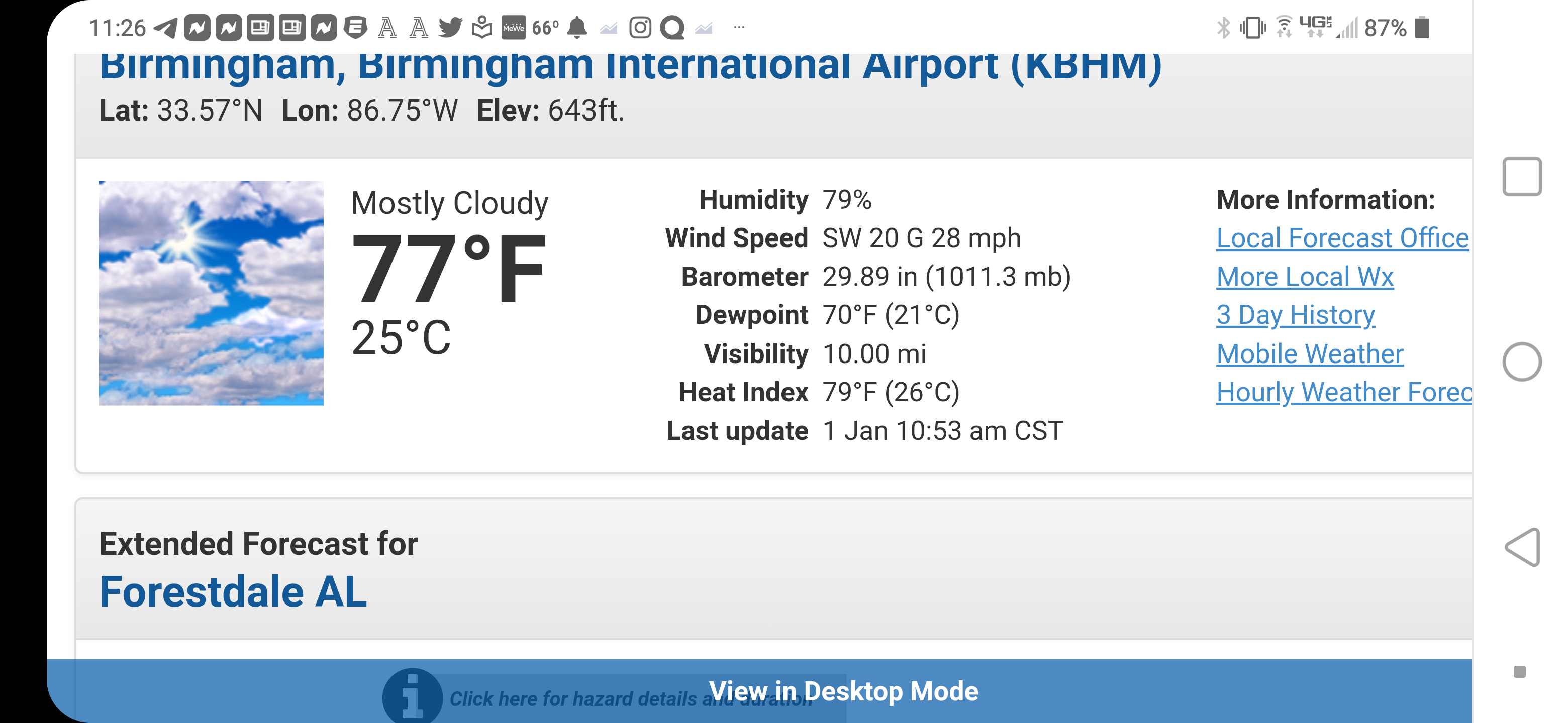
Bham temp 77 dewpoint 70 on NYD!?!? This would be impressive for even Tampa Bay in January!
-
WOW! Bham 77 temp 70 dewpoint! This would be impressive for Tampa Bay today! But the best dynamics appear to be NW of us. Happy 2022 everyone while I'm at it.