purduewx80
-
Posts
1,705 -
Joined
Content Type
Profiles
Blogs
Forums
American Weather
Media Demo
Store
Gallery
Everything posted by purduewx80
-
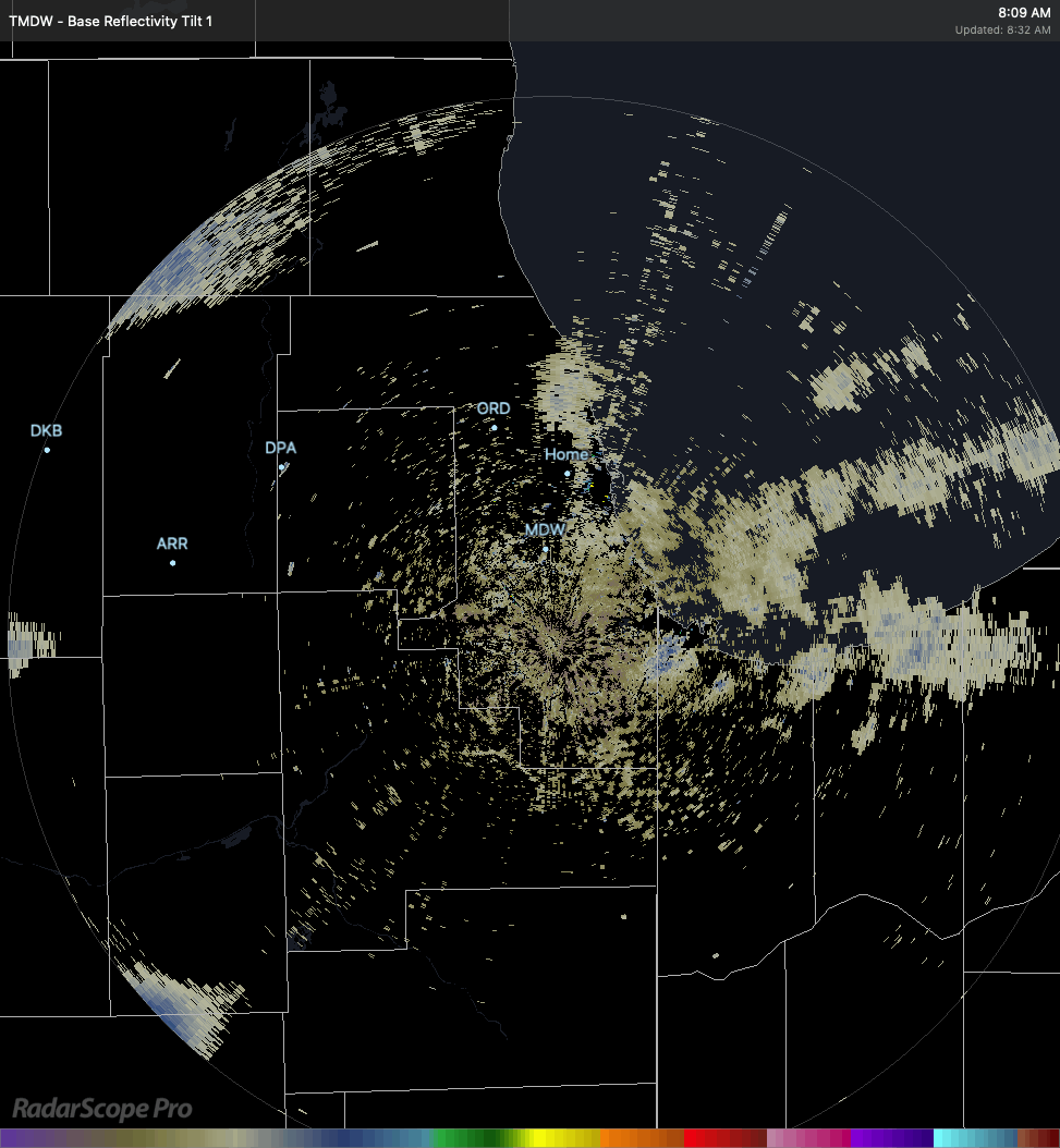
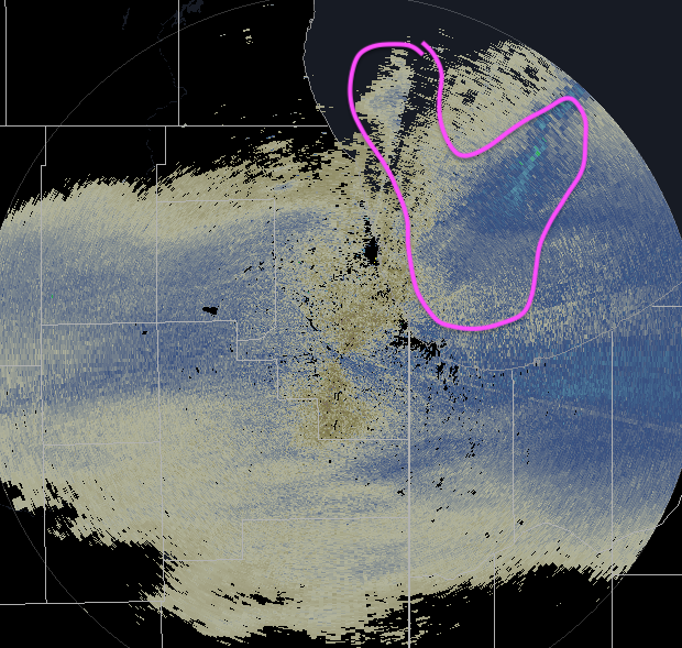
Some sneaky lake effect creeping into IL now (click to animate). Flurrying here, looks like some nice dendrites on the downtown cam. Sfc winds still have a westerly component but they're out of the ENE either side of 950mb.

-
Winter 2020-21 Medium/Long Range Discussion
purduewx80 replied to Hoosier's topic in Lakes/Ohio Valley
Changes I mentioned in the weekend thread go on to allow for positive changes w the Mon-Tues system on the 12Z EPS. Almost 20% of members show big dog potential for the subforum early next week. -
Feb 12-14th V-Day Weekend Potential Stuff
purduewx80 replied to Chicago Storm's topic in Lakes/Ohio Valley
EPS looks great for Fri-Sat. Made some positive changes similar to the op run. Looking at some of WPC’s cluster products, a lot of the sensitivity is tied to how and when the PV heads East and resultant heights in the NE (overall the 12Z EPS is slower w ejecting it). Also some timing issues w Pacific energy as usual. -
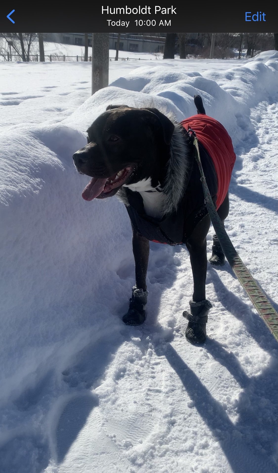
Finally got these gd boots on my pup. We haven't been able to take her on long walks in 3 weeks. She was stoked to get out there and play in the fresh powder this morning.

-
Across the river in Harrison & Floyd Co., IN. My dad has a plow on his tractor and helps out some of the older neighbors too.
-
Your neighbors must love you. I grew up near Louisville and don’t recall anyone around there ever having a snowblower.
-
Nice. This one was a lot easier to measure here than most due to the lack of wind. Everything had melted or fallen off the deck railing prior to today. Great call on the WWA today btw.
-
Up to 4.6" as of 8. Tree branches are just barely starting to sway after being completely still all day. Have seen a few clumps of snow fall off as a result.
-
Will do at 8! Pouring again.
-
Has to be close to a record high snow:liquid ratio there. For once the wxbell kuchie maps were spot on.
-
3.5” here so far.
-
strange you haven't had larger flakes more frequently. suspect we are seeing some lake enhancement in chicago, because there have been large flakes falling at varying intensity since i woke up this morning. shame for those on either side of the band coming in, which will only end up being about 20 miles wide. still watching a possible 2nd round of enhancement overnight, although it seems evident from radar and obs in IA snow will keep going through the evening. would watch areas near and just south of the best snow this afternoon, probably in chicago from ~9pm - 1am. dry air will start to come in and the lift isn't necessarily perfectly centered in the DGZ w/ that round, so it may not be as effective as this afternoon's.

-
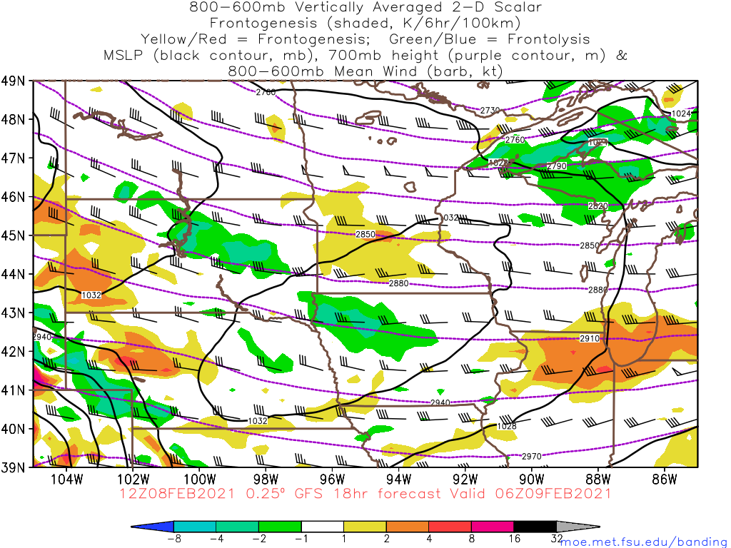
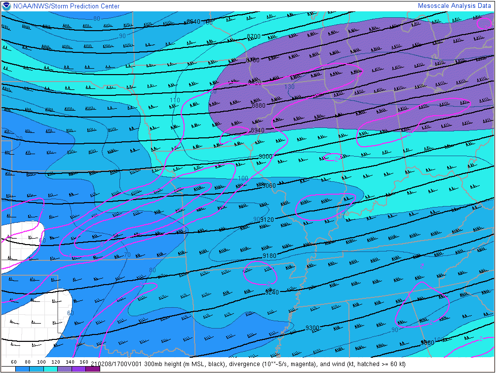
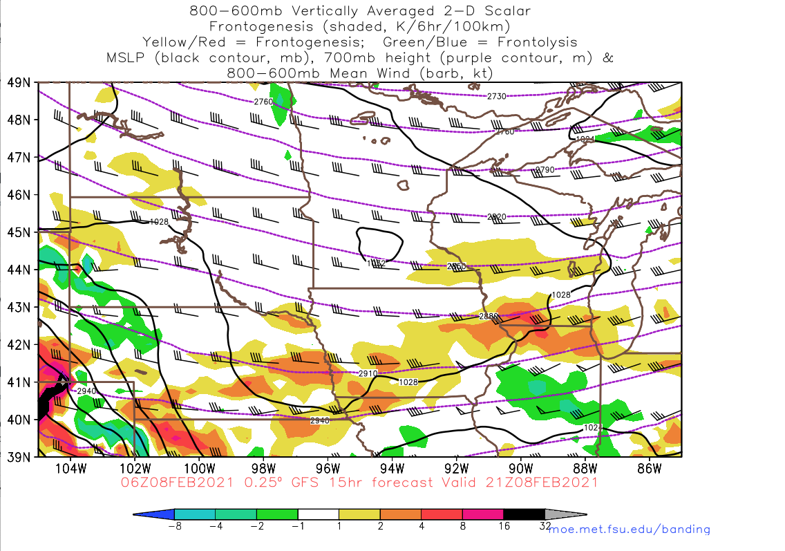
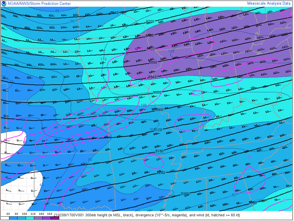
this is where old-school meteorology gave us some clues for today. not too surprising that fgen forcing is more intense than modeled given this jet streak passing by (it gradually lifts NE from where it's shown below). shame it won't be in place longer than a few hours. That said, there is focus at 700mb through the night, so light snow may end up persisting all the way into tomorrow morning in the general areas its occurring now.
-
DVN put out an advisory. Ricky is on today so I think you know what's coming...
-
Lake effect is very close to the Chicago shore this morning. Some of the guidance yesterday suggested it could come into downtown w/ the synoptic snow this afternoon/eve, but it looks like there may end up being a mesolow that keeps it just offshore. Close call though. Cedar Rapids to metro Chicago should be in good shape for 2-4". Wouldn't doubt if there are some locations that pick up more than that looking at radar trends and obs in Iowa.
-
Been a snow globe all morning. Flurries already doing a decent job of covering the black snow.
-
Later this afternoon doesn't look too bad near and north of 290/88 up to the WI border, as long as moisture isn't an issue. Best frontogenesis-produced lift in the DGZ focuses in these areas for several hours. There is good right entrance region jet dynamics helping this along. Could be some of those 30:1+ ratios where the banding sets up.

-
Winter 2020-21 Medium/Long Range Discussion
purduewx80 replied to Hoosier's topic in Lakes/Ohio Valley
Fixed your post. -
Hopefully the lake doesn’t freeze before then
-
A deep-dive into the system’s innards on AWIPS and BUFKIT was revealing yesterday. They all did a nice job showing the best crosshairs signal (lift + DGZ) where the relatively heavier snow occurred, despite QPF placement being incorrect. Shame the forcing was so high up when the super deep DGZ was based at the surface. Good reminder that model QPF and weenie snow maps have a long way to go. NE did see some stellar ratios out of this at least. Omaha saw 31:1 ratios and Lincoln had 36:1.
-
Those of us lake-side in WI/IL could finally have a more legit lake enhancement setup w/ this one. Decent agreement on that on 00Z guidance. Seeing the SE ridge perk up in the extended with a vortex from Canada into the West/Plains at times and Pacific energy undercutting it - would be a waste of a pattern if we don't get a bigger storm at some point
-
O’Hare came in w a 10:1 ratio too (0.7” on 0.07” liquid). The observer near Midway had 0.8” on 0.05” liquid (16:1).
-
I have a huge amount of respect for someone like him who has to dumb this down for the average TV viewer. There isn't always an easy way to communicate science, unfortunately.
-
Unfortunately, as today is proving, it's far more complicated than that. Take DSM for example. Assuming the snowfall and QPE numbers are right, they recorded 1" of snow on 0.10" of liquid between 6AM and noon. That's a 10:1 ratio. Their surface temperature was 6-7F, which according to Skilling's chart, would end up producing snow of 4". It has more to do with the vertical velocities in the cloud layer than just about anything else. Those 20-40:1 ratios would only occur where the best lift coincided with a saturated cloud layer with a temperature from ~-10 to -20C (the middle of that range is best). There are many other variables that affect snow:liquid ratios that involve cloud microphysics, chemistry, physics and so on. It's a difficult thing to model perfectly, and we probably have a ways to go before your typical model websites are able to accurately portray what's going on. Ricky covered this at the top of the page, so re-read his message to see a little bit of why today didn't work out for everyone.
-
What’s your flake quality like?