purduewx80
-
Posts
1,705 -
Joined
Content Type
Profiles
Blogs
Forums
American Weather
Media Demo
Store
Gallery
Everything posted by purduewx80
-
Low-level thermals are meh, but there should be a little enhancement from the lakeshore convergence and seeding from the 700mb forcing. Probably a case of be careful what you wish for, because to get an influx of colder air at ~850 than is currently modeled, you'd more than likely end up squashing the system back to the south.
-
Winter 2020/2021 Short Range Discussion
purduewx80 replied to Chicago Storm's topic in Lakes/Ohio Valley
In case you missed it, the PDF in Ricky’s link mentions an airline official at ORD reported 1” of accum in 10 minutes. 6”/hr rates are extraordinarily rare around here and are usually observed in areas with forced orographic lift or in Nor’easters where you have moisture transport off the Gulf Stream and strong frontogenesis. In this case it was more the forced ascent caused by that compact vort in an atmosphere w/ steep low-level lapse rates centered in the DGZ. -
Winter 2020/2021 Short Range Discussion
purduewx80 replied to Chicago Storm's topic in Lakes/Ohio Valley
TSSN in SW WI. Looks like a narrow swath of heavy snow is accompanying the intensifying vort max. -
Winter 2020/2021 Short Range Discussion
purduewx80 replied to Chicago Storm's topic in Lakes/Ohio Valley
speaking of persistence, another morning of anthropogenic snow in the midwest:
-
Winter 2020/2021 Short Range Discussion
purduewx80 replied to Chicago Storm's topic in Lakes/Ohio Valley
I wouldn’t go that far. “Convection” does not mean lightning and thunder are always involved. The convective profile would need to favor cloud tops at or colder than -30C for sufficient charge separation, and there isn’t much evidence of that in current guidance. At least locally, cell motions do not look all that rapid. Steering flow is only 5-15KT, so I think some of these will end up producing surprise amounts tomorrow, especially near any enhanced surface convergence. Nowcasting will have to involve looking for local “heating”, upper level vort max support and any surface troughing, which is similar to what we look for when forecasting thunderstorms in the summer. -
Counterpoint, by a virologist, to the science fiction opinion article written by the clever writer a couple weeks back.
-
Winter 2020/2021 Short Range Discussion
purduewx80 replied to Chicago Storm's topic in Lakes/Ohio Valley
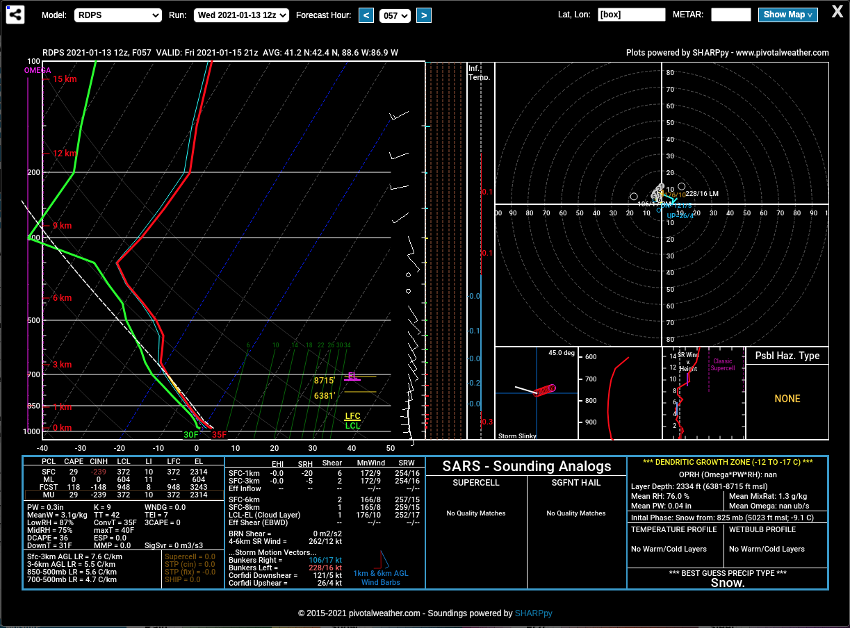
This is an area average sounding at 3PM Friday for the Chicago metro from the RGEM. Surface-based instability that includes the DGZ would be a good setup for mod/hvy snow showers.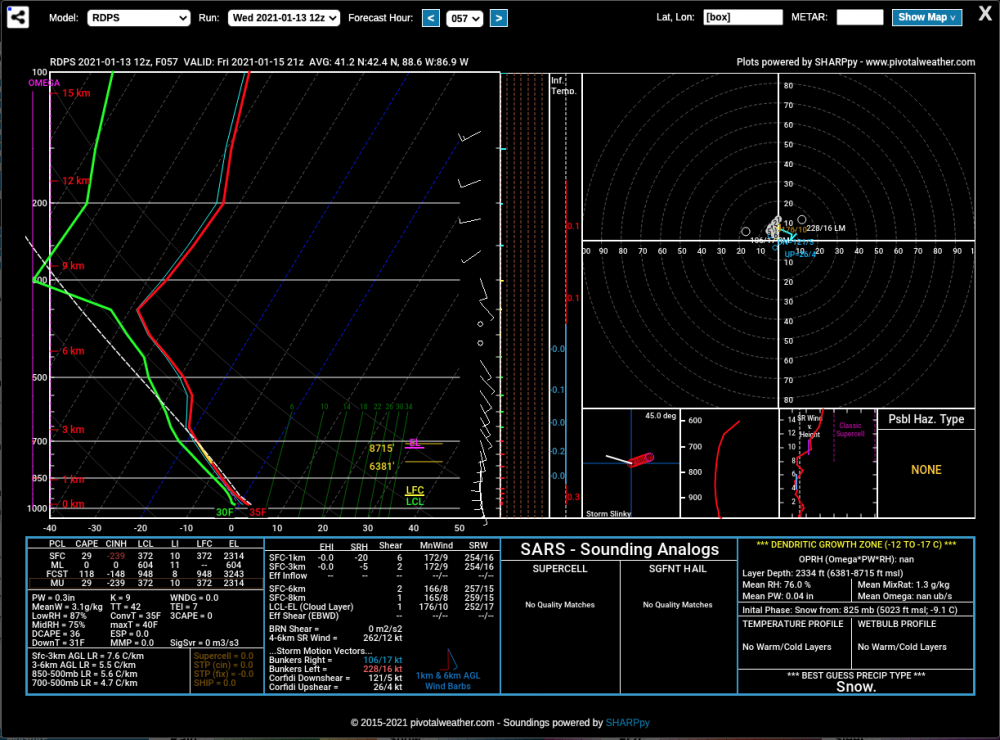
-
Winter 2020-21 Medium/Long Range Discussion
purduewx80 replied to Hoosier's topic in Lakes/Ohio Valley
p.s. it's still there on the 00Z run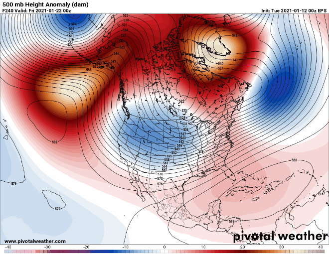
-
It is pretty bizarre. Working in aviation, we pay a lot of attention to cloud heights, depths and in-cloud temperatures. It would be hard to do a historical analysis, but we have seen this persistent pattern since late November where cloud depths are too shallow and warm for significant lake effect. At the same time, there has been an increased incidence of aircraft icing on their way in/out of ORD and MDW. These conditions are also what have led to the prevalence of aircraft- and industrial-effect snow.
-
In case you missed it.
-
Would love to know why none of you It'S nO bIg DeAl types are ignoring the other long-term health consequences, many of which we probably don't even know about yet. There are an increasing number of studies looking into the decline of brain health, among other lasting issues. For all we know, the president's widely reported detachment from reality could be a direct consequence of his infection last year.
-
That's been happening a lot this week! With all the fog and low clouds around, we have more than enough moisture. Local industry has largely been feeding the surprise flurries/snow showers (likely a combo of heat/steam and particulates that act as ice nuclei). There have even been isolated locations around that have picked up 1-2" of accumulation where they've been more persistent.
-
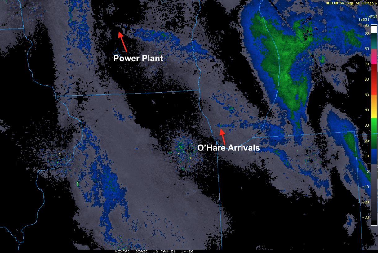
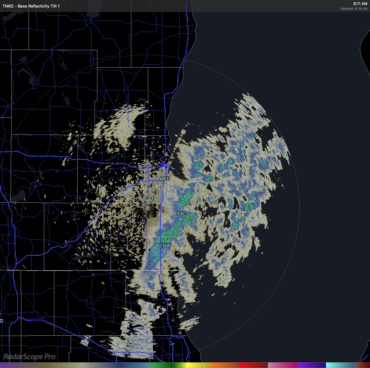
Nice! Yeah, It's too shallow for DTX or APX radars to pick up. These echoes are from the closer-to-the-lake and more sensitive terminal doppler, TMKE. It doesn't looks as impressive on the NWS radar.
-
Some legit lake-effect in southeast WI this morning. Remnants should eventually make it to Chicago, but I imagine it won't be quite as intense. Kenosha: KENW 081401Z 35006KT 1/4SM SN FG OVC012 00/M02 A3030 RMK AO2 P0000 T00001022 Racine: KRAC 081405Z AUTO 03012G21KT 1/2SM SN FG OVC005 01/M01 A3031 RMK AO2 P0001 T00061006

-
JFC that is science fiction. He is a literal fiction author, not an expert on anything related to any of this.
-
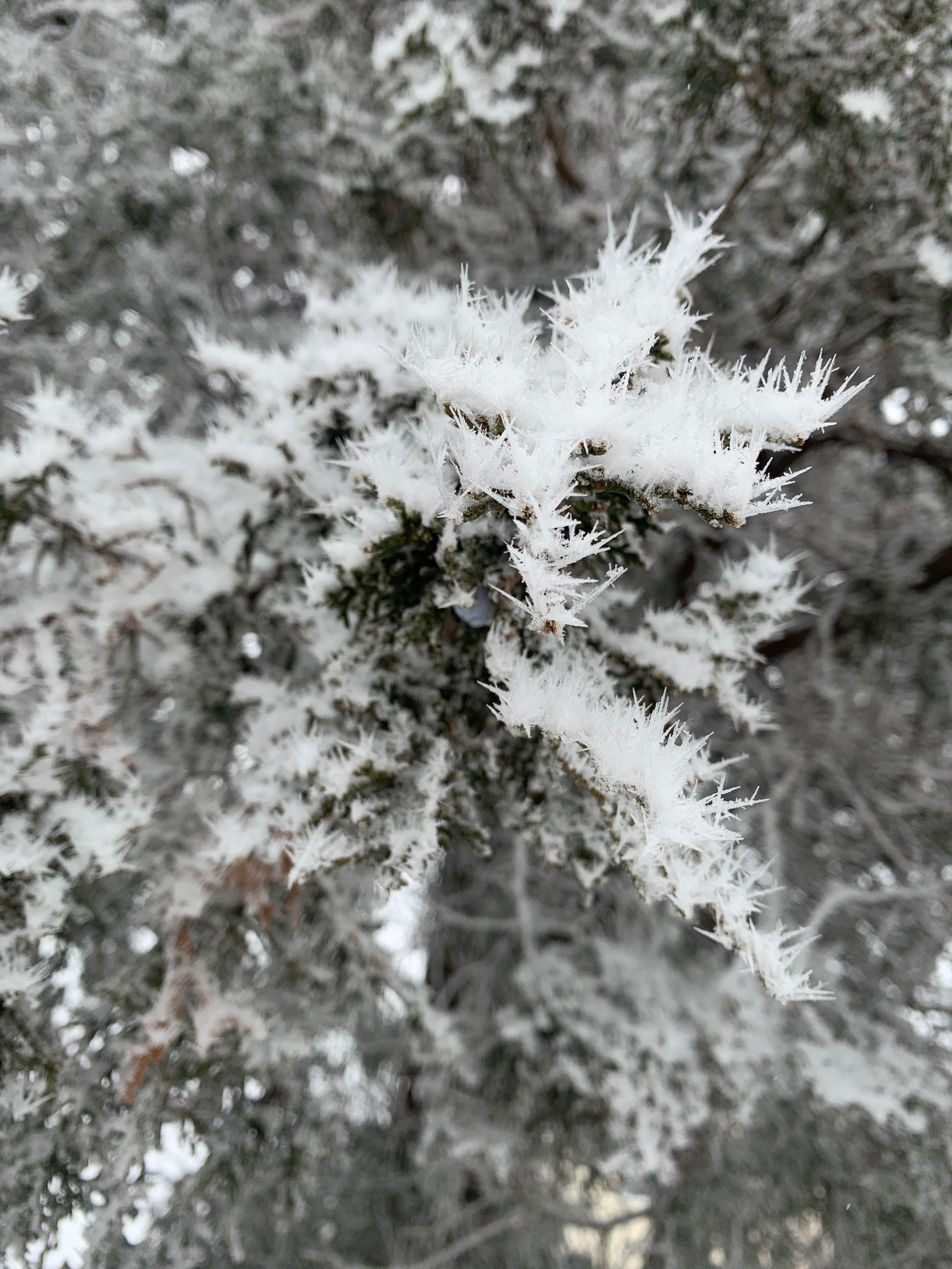
It really was incredible out in Aurora. South-facing surfaces collected the most due to the light S/SW breeze today.
-
They’re showing up on the terminal Doppler radars. Pretty clear they’re smokestack/industrial-effect given the point plumes. You can see this on the early AM vis sat too where plumes are creating locally deeper clouds.
-
Still a lot of disagreement on the temp profile, but with the TROWAL (trough of warm air aloft) feature and compact upper low moving in, there will be some convective elements to the precip shield. With all of that, there should end up being a narrow band of +SN that pivots nearby later tomorrow evening.
-
NAM is often far better with lower level thermals than other guidance, but it is a northern outlier with the sleet/freezing rain. That said, the 12Z HREF (ensemble of hi-res SPC models) shows the mixing getting up to a Janesville-to-Milwaukee line overnight. We'll have a better idea of how the mixing line is trending in a few hours.
-
I'm just pointing out with actual observed data rather than a model that the dry air is very real and significant. The initial forcing will be wasted in moistening that layer, the top down saturation others have mentioned is why we go from flurries to heavy snow in short order. No reason the Chicago area will not see a 2-3 hour period of heavy snow this evening. The SPC has a nice sounding climatology page that shows how dry the air over IL was this morning at 12Z compared to the past.
-
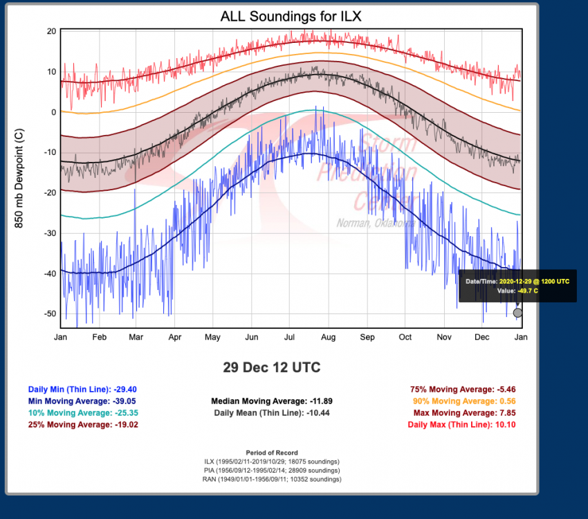
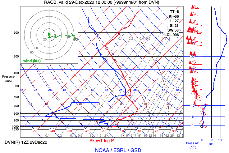
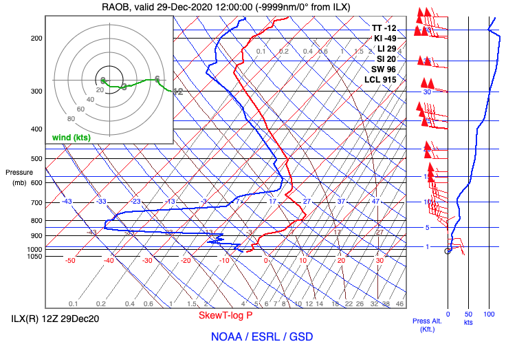
12Z soundings from DVN and ILX do show the incredibly dry air from ~650 to 900 mb. Dewpoints below -50C in that layer are among the lowest ever observed in both locations.
-
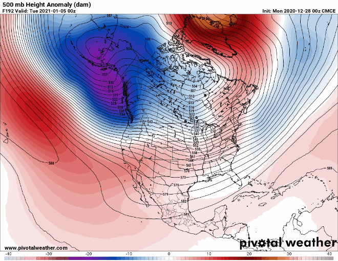
Heck of a -NAO developing on most guidance now for early January. Will get the East Coast weenies in a tizzy. That trough in the Gulf of Alaska would flood the US w/ mild Pacific air, though.
-
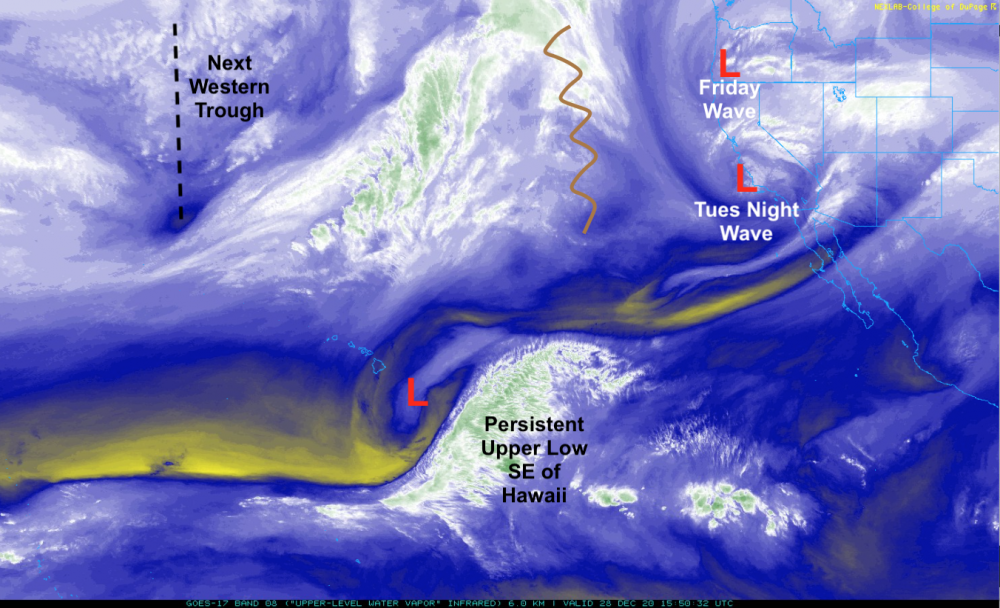
Wanted to take a little break from the model bombardment. Our players are about halfway on the field now. The first system has given LA an early AM round of thunderstorms. That ridge (zigzag) off the West Coast pumps back up quickly after the next trough passes through and then digs into Mexico (similar to the Friday wave), thanks largely to the persistent upper low to the southeast of Hawaii. All of that teleconnects to ridging along or just off the East Coast. There's a lot of convection in the tropics/sub-tropics playing into the pattern, more than what can be shown on this satellite. Once the Friday wave digs into Mexico, the ridging ahead of it (over the eastern Gulf, Florida and the Bahamas) will likely be beefed up by convection developing over the warm Gulf of Mexico. That process is partially what allows the warm air aloft to flood north ahead of the upper low, bringing the risk for mixed/freezing precip as high pressure to the north continually feeds lower level cold/dry air.
-
Why, meteorologically?
-
It's possible with a large enough cut-off low and high enough amplitude ridging/blocking pattern, but def agree it's somewhat laughable for now.