purduewx80
-
Posts
1,705 -
Joined
Content Type
Profiles
Blogs
Forums
American Weather
Media Demo
Store
Gallery
Everything posted by purduewx80
-
Gosh, they must’ve heard you.

-
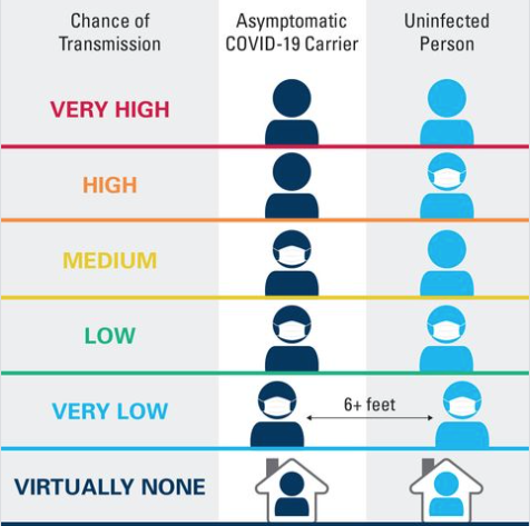
Notice it doesn't say zero risk. It's also more complicated than that. Many people take their masks off to eat at work; is there sufficient ventilation in the shared spaces? Are people wearing masks that fully cover their nose and mouth? As Hoosier pointed out, relatively milder symptoms can be expected when transmission does occur since masks lower the received viral dose.
-
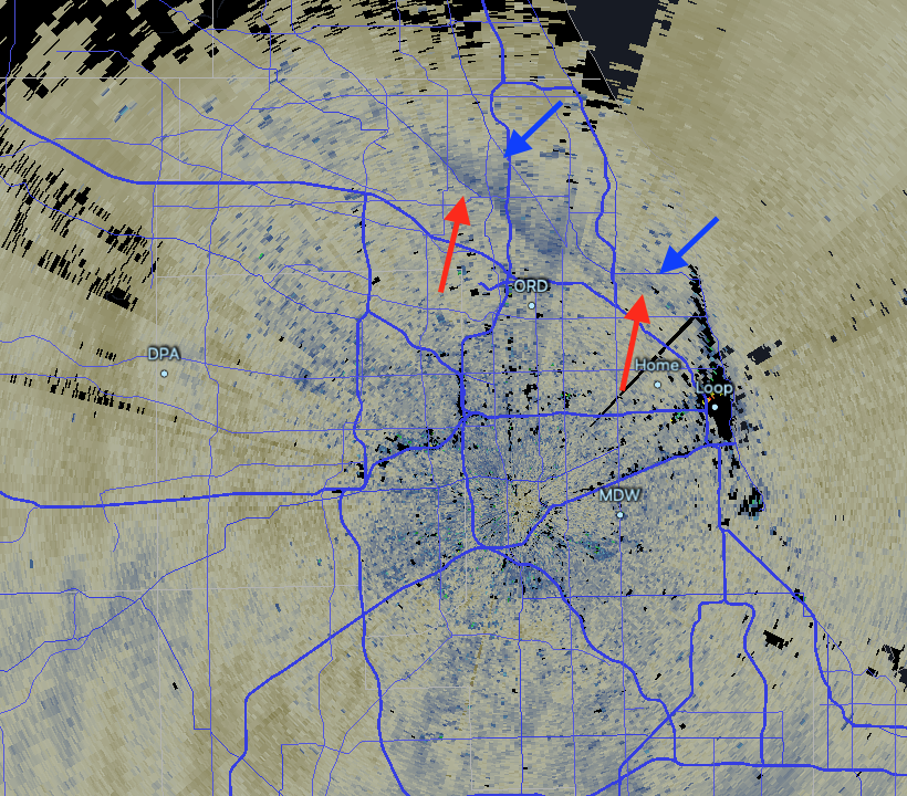
64MPH gust at ORD.
-
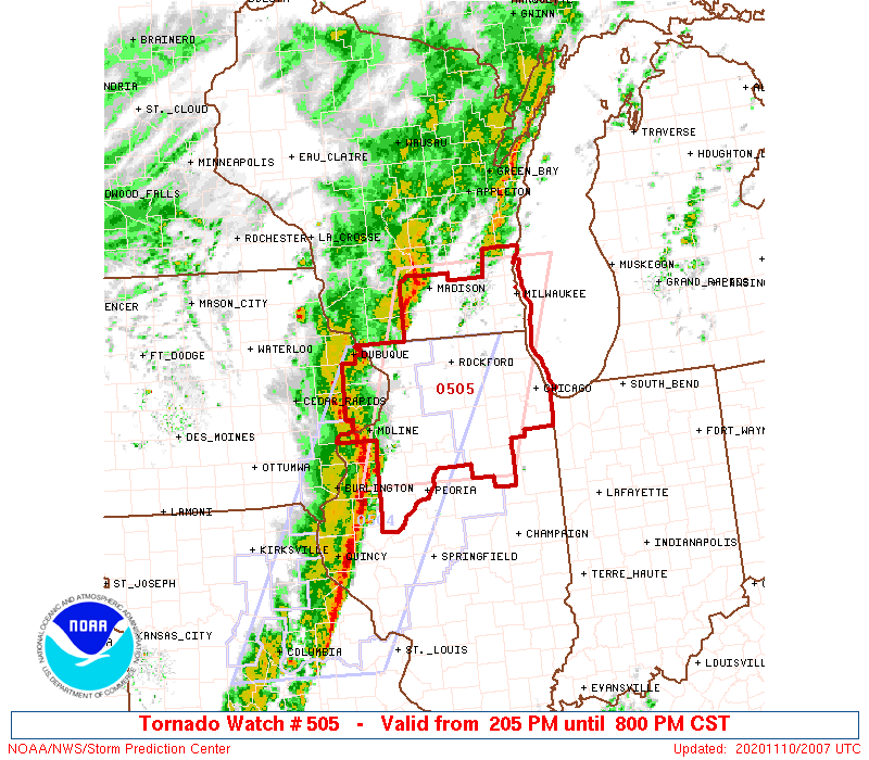
Tornado Watch out:
-
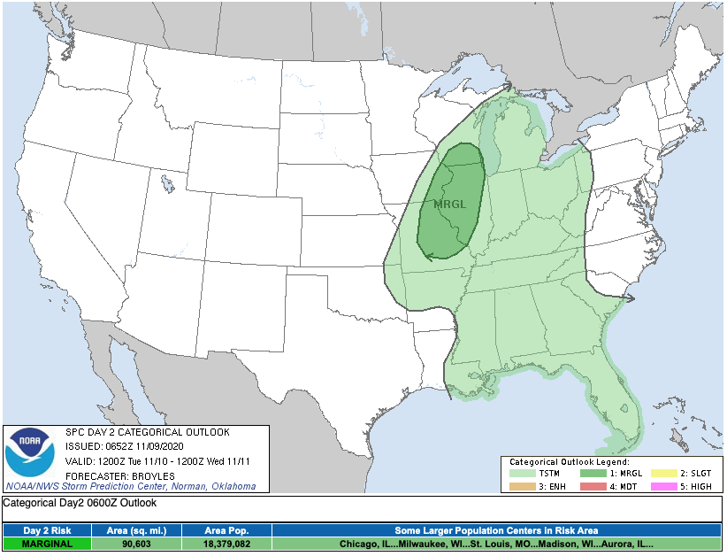
Close call for Chicago. Def a higher risk just W/NW given the timing. We will lose some instability after sunset but this could be offset a bit as shear increases owing to the LLJ accelerating to 50-60KT.
-
Sorry to hear about this, but thank you for the important anecdote about long-haulers. Too many people haven't heard about it or don't believe it's true. Hope they are well soon.
-
The surface low is back in the cold air in Iowa, but there is a meso-low in SE Iowa causing surface winds to back more SSE in the warm sector. The relatively highest tornado risk will be from the Quad Cities to near Rockford and perhaps far SE WI this afternoon, especially where showers ahead of the line feed into it.
-
Warm front has been retreating near the MS River but I agree that with the exception of far SE Dane County, you're probably in the clear there.
-
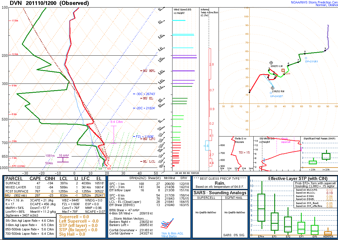
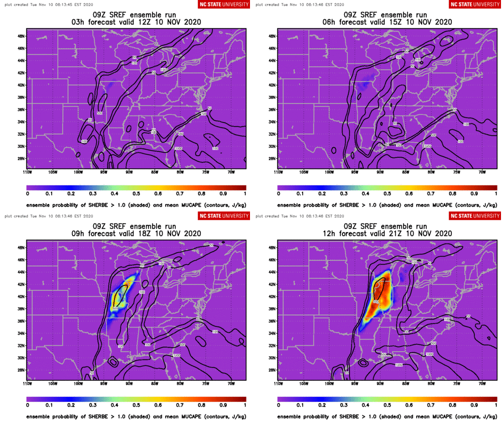
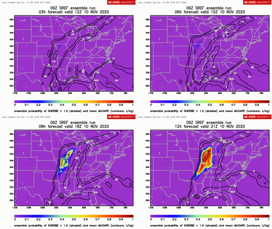
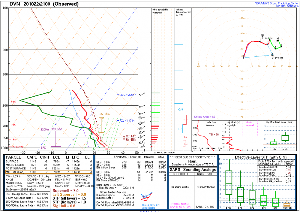
Mid-level lapse rates are as steep as 8.4C/km at DVN this morning; traditional 700-500mb lapse rates are a bit skewed due to the influence of the historic ridging (notice warm nose at 500-550mb). These lapse rates will adjust later as the upper wave brings cooling at both 500 and 700 mb. This is an experimental high shear/low CAPE product being run at NC State. The red shading basically indicates areas that favor spinups either in the QLCS or in supercells that may develop.

-
November 2020 General Discussion
purduewx80 replied to SchaumburgStormer's topic in Lakes/Ohio Valley
Agreed. This warm weather should encourage those in MN/WI/MI at least given the impressive La Niña conditions in place. -
November 2020 General Discussion
purduewx80 replied to SchaumburgStormer's topic in Lakes/Ohio Valley
Pretty good signal for TSSN and/or TSPL with the deepening lows passing by too. Heck of a way to end a warm spell. -
Wise move on their part. Forecasts based on instability from the NAM or GFS the past few days are unrealistic given the former's bias of being too cool in the boundary layer (too cloudy/moist; temps 5-10F too cool in this warm spell) and the latter's lack of resolving temp/moisture profiles correctly. More importantly, with the dynamics in play and as we see with more classic 2nd season events, it's more about the instability and shear from the surface to 3km. From a pattern recognition perspective, a deepening low with 60-degree+ dew points and a 50KT+ LLJ in Nov tells us more than any one model can. It's possible there isn't a ton of lightning, but with the wind field in place I imagine some scattered wind damage could occur. The placement of SPC's 2% area for tornadoes looks good to me.
-
November 2020 General Discussion
purduewx80 replied to SchaumburgStormer's topic in Lakes/Ohio Valley
Averaging the four major globals would put dew points near 60F w/ PWATs well over 1". More than enough w/ those dynamics in November. Having the high where it is and the tropical in the Gulf could actually be a good thing in that an indirect feed of moisture (from the Atlantic rather than the Gulf) won't allow for widespread low clouds to reduce the chances of heating up ahead of the front. To me, the more likely thing that could go wrong is that the Rockies energy ejects in pieces, in a positively tilted junk way that doesn't allow for a more consolidated, deepening low. Some guidance still hints at that scenario.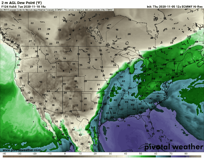
-
November 2020 General Discussion
purduewx80 replied to SchaumburgStormer's topic in Lakes/Ohio Valley
There is typical disagreement for being ~5 days out, but this would probably be a decent severe weather threat next Tuesday if it verifies: Cue the La Nina SE ridge being amped up by a November Gulf hurricane.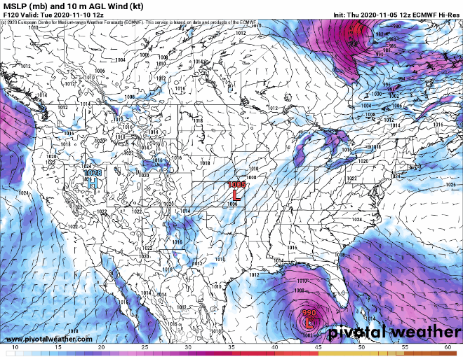
-
November 2020 General Discussion
purduewx80 replied to SchaumburgStormer's topic in Lakes/Ohio Valley
74 at ORD today tied the record. -
Except it’s HUGELY relevant.
-
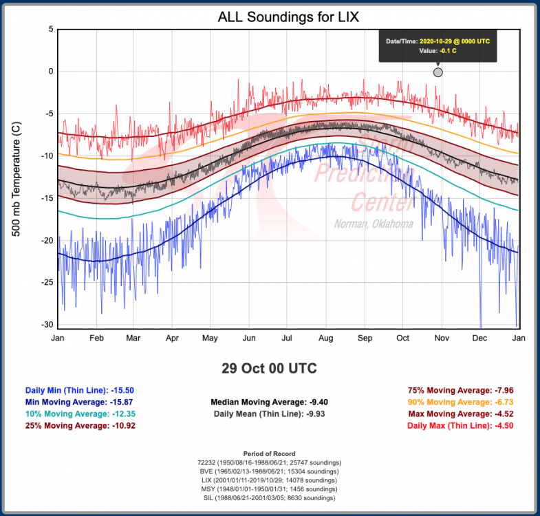
The New Orleans NWS office was able to launch their 00Z sounding within the eye. It recorded their warmest 500mb temperature in its history (back to 1948).
- 508 replies
-
- 18
-

-

-

-
It was 34 at my place while snowing, too, and nothing stuck to anything. It's not terribly surprising for snow to not stick during the day when it isn't moderate or heavy. The actual vis reported by the RVRs (runway visual range sensors) was not 3/4SM more than a few minutes, nor was it a mile for that long.
-
It sounds to me like you're saying protests occurred en masse because of "lockdowns" - is that what you're getting at? What you also clearly don't get is the plight of Black Americans, who by the way, are still disproportionately affected by the pandemic.
-
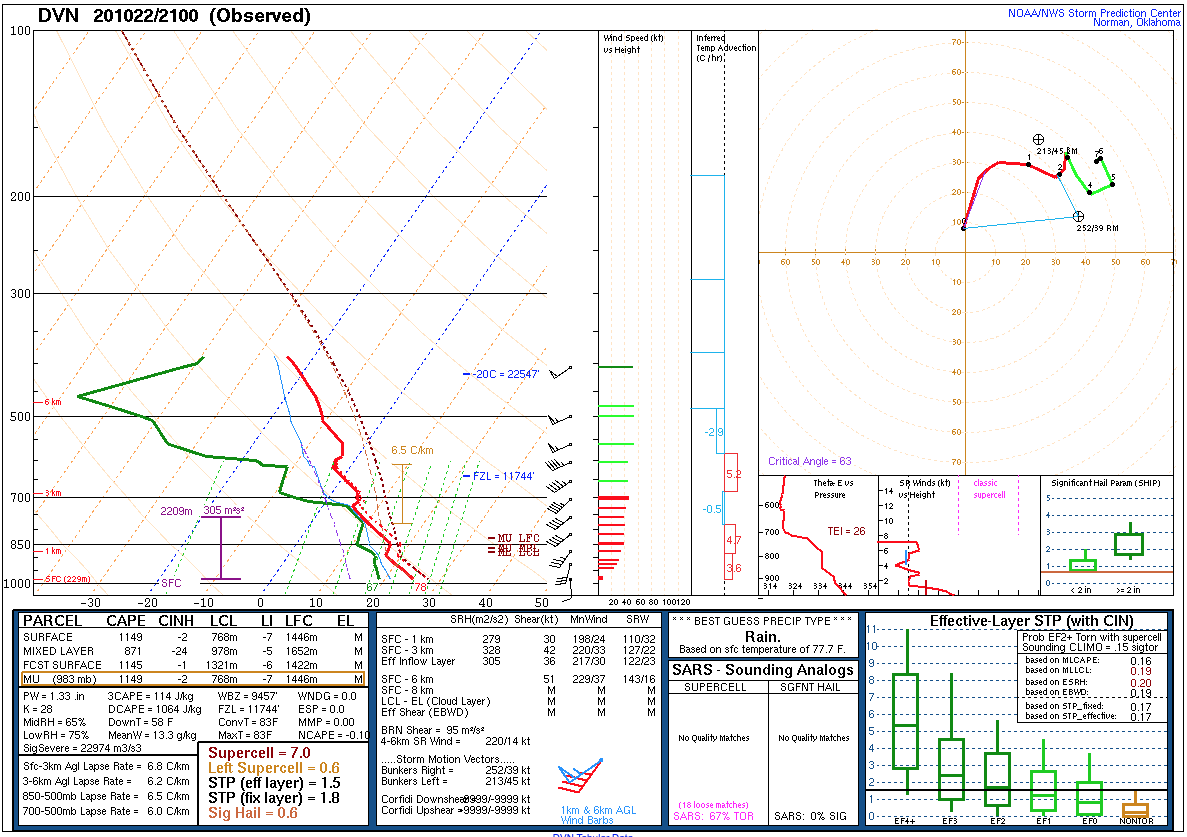
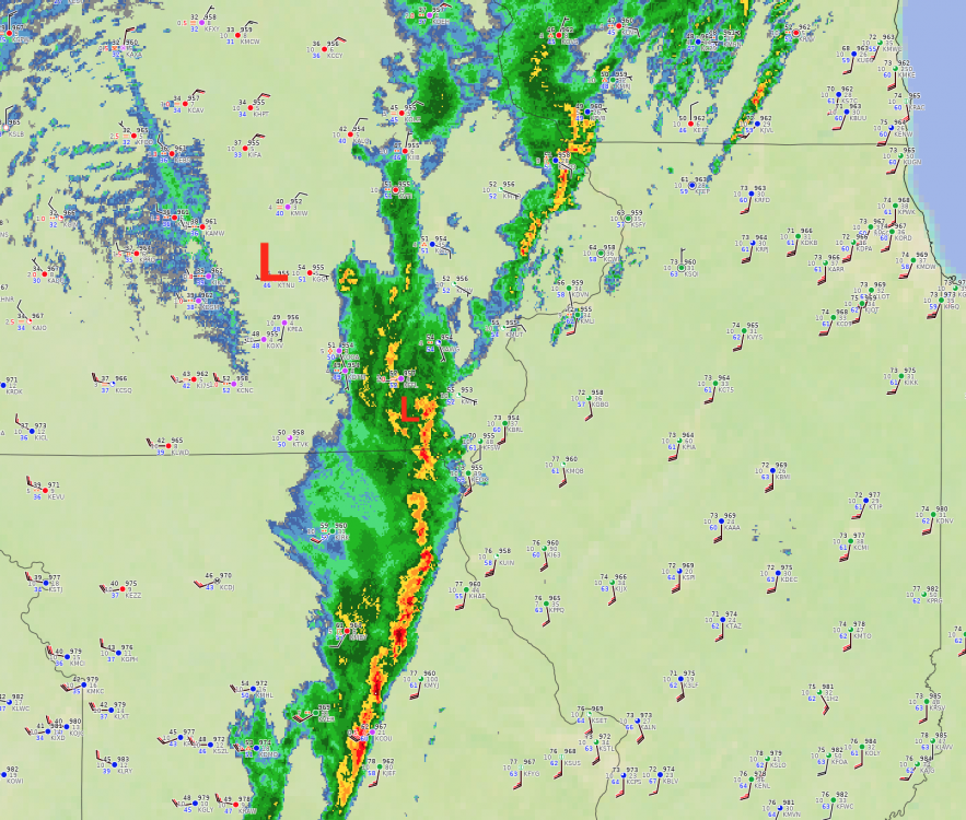
So close to being something more substantial near the MS River. The 21Z special sounding out of DVN has a favorable wind field for tornadoes, but a few warm layers and the marginal mid-level lapse rates may keep keeping it from producing. It got warm enough for a lake breeze to edge into the northern metro this afternoon, but the increasing southerly flow is allowing it to retreat back north now.
-
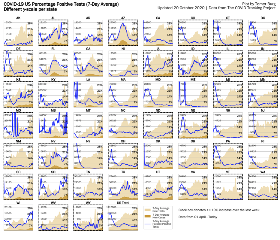
Good news, and they point out that it's due to a number of reasons. 1) we know more now than in the spring, 2) more widely available treatment options, 3) more widespread wearing of masks reduces initial doses of the virus and 4) hospitals aren't overwhelmed (for now). They specifically point out that if hospitals become 100% saturated that numbers will go back up. Every state in the Midwest has a rising percent positive case rate. Obviously, testing is increasing now because more people are getting sick. The percent positive case rate is also increasing on average at the national level and is now above 5%.


-
Could conceivably be in the low 80s Thursday. All the globals bring the warm front through, but the ECMWF is the only one fast enough to get us there. Record of 87 at ORD is most likely out of reach, though.
-
Lots of ups and downs ahead. Good shot of warmth Thursday and Friday (widespread 70s and humid) with a risk of thunderstorms. Dakotas and MN should do well in terms of early season snow over the next couple weeks. Maybe even some blizzard conditions.
-
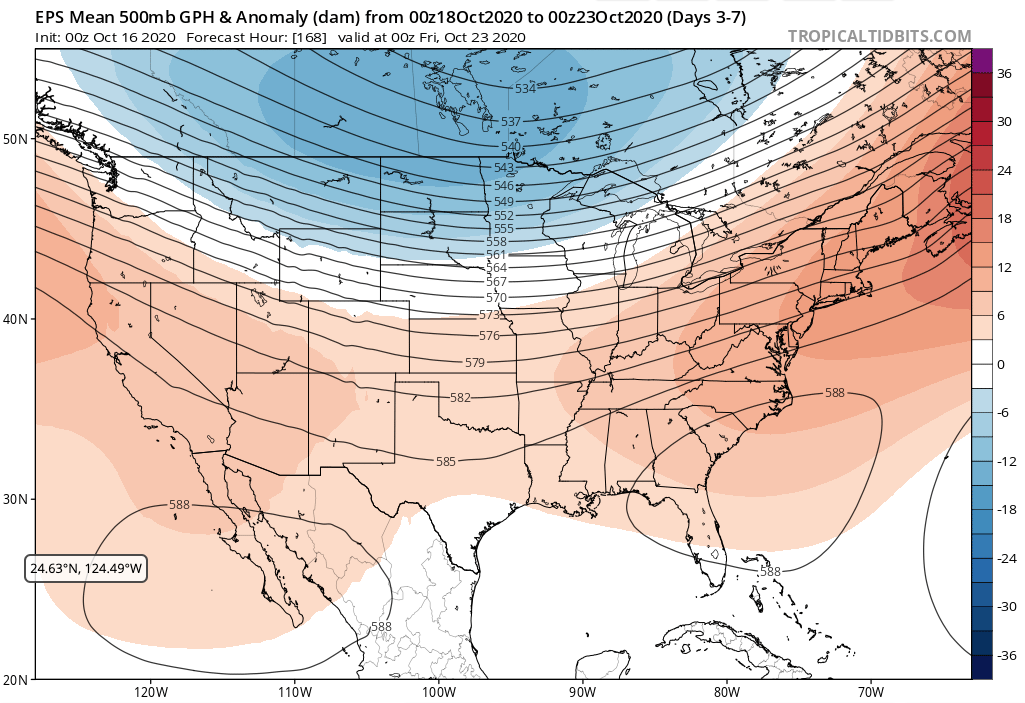
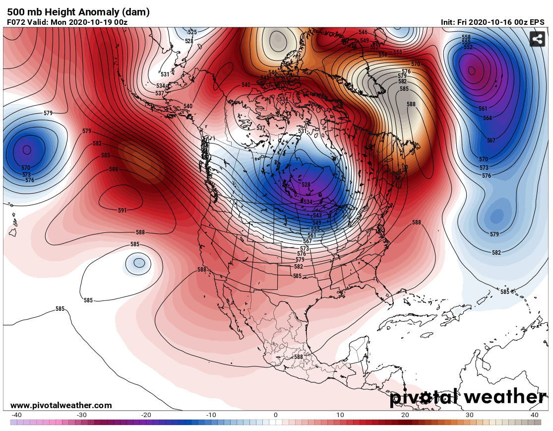
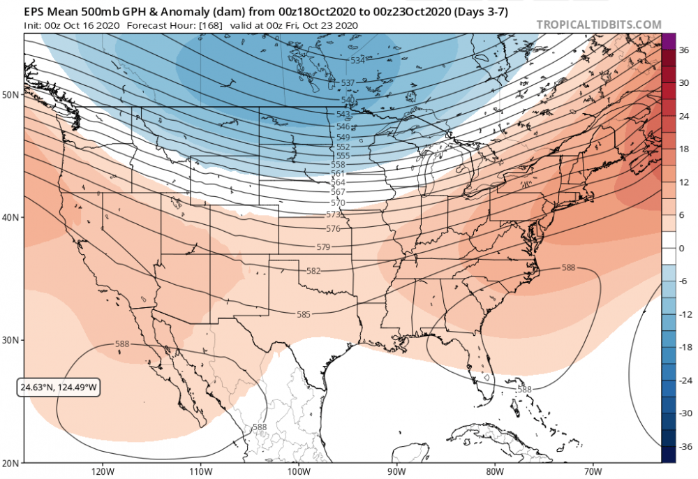
At the very least the upcoming pattern looks more exciting than what we've seen of late. Blocking over the N Atlantic and N Pole this weekend will continue to allow Arctic air into North America, then it's hello La Nina/Southeast ridge later in the week. At the least recent precip deficits should see a big dent. It'll be interesting to see how the Tropics play into the pattern later next week, too.

-
No doubt. One of my favorite weather memories involved hearing what ended up being a billion-dollar hail storm with baseballs approach my place in Madison, WI. No roar quite like that. It was in the 40s out during April to the north of a warm front.