purduewx80
-
Posts
1,705 -
Joined
Content Type
Profiles
Blogs
Forums
American Weather
Media Demo
Store
Gallery
Everything posted by purduewx80
-
Jan 24-26th Potential Something Part 2
purduewx80 replied to Chicago Storm's topic in Lakes/Ohio Valley
For sure. Literally the best model tool in the game IMO. -
Jan 24-26th Potential Something Part 2
purduewx80 replied to Chicago Storm's topic in Lakes/Ohio Valley
So what you’re saying is, neither the 10:1 or Kuchera maps are 100% accurate? Definitely agree on the locally higher ratios wherever the better meso forcing sets up. Probably lose some of that to riming and fracturing I’d think. -
Jan 24-26th Potential Something Part 2
purduewx80 replied to Chicago Storm's topic in Lakes/Ohio Valley
Yes, exactly. There is a large amount of collaboration that takes place and consistency from office to office is pretty much essential. This is true in both the private and public sector. Ultimately all of that will usually end up producing a superior forecast rather than letting one person or idea drive the bus. -
Jan 24-26th Potential Something Part 2
purduewx80 replied to Chicago Storm's topic in Lakes/Ohio Valley
Primary differences though are that we have no terrain to enhance convergence, and y’all also have salty ocean air which can produce efficient snowflakes at warmer temps. I kinda feel like the warmer temps and stronger winds near the lake here Monday will negate any modest lake enhancement. Tuesday is a different story if the colder/slower solutions verify. -
Jan 24-26th Potential Something Part 2
purduewx80 replied to Chicago Storm's topic in Lakes/Ohio Valley
Always fun to come in here and see people who aren't meteorologists question the decisions made by the professionals. Easy to be critical when you're hiding behind a screen from a dark corner in the basement. LOT explained their reasoning for not issuing a watch, I'm sure we'll see DVN's here shortly. The products look to be consistent with other NWS guidance, particularly from the WPC. 48-hour probabilities for at least 8" of snow: Surface low track w/ ensemble positions plotted (indicating the amount of spread in both timing and track/location):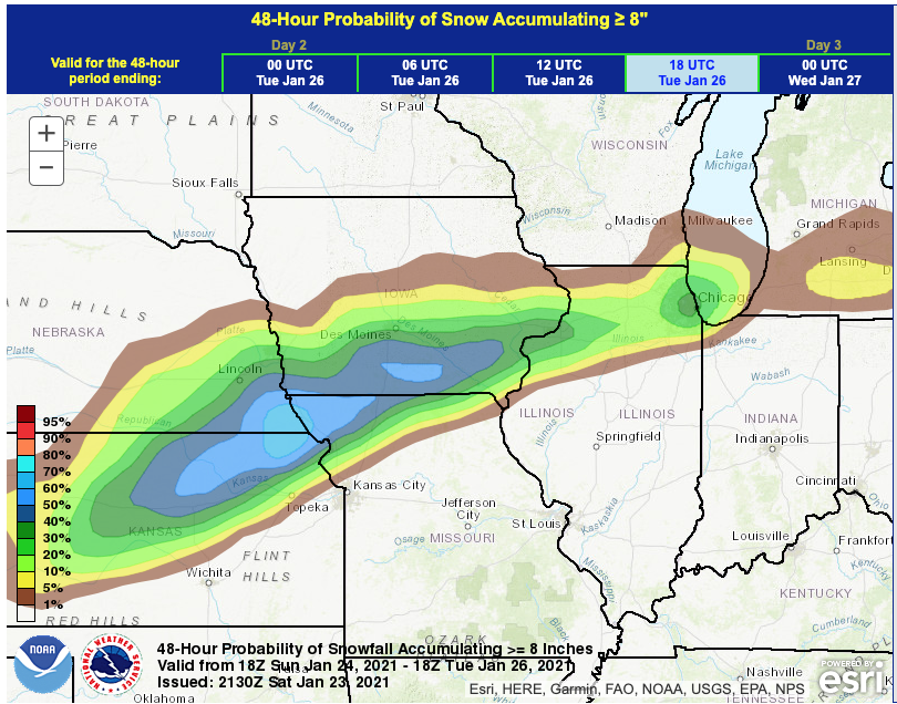

-
Jan 24-26th Potential Something Part 2
purduewx80 replied to Chicago Storm's topic in Lakes/Ohio Valley
The overnight AFD didn't say that. It's definitely still offshore. The system tomorrow is already well inland now. AFD for reference, it's a doozy: -
Jan 24-26th Potential Something Part 2
purduewx80 replied to Chicago Storm's topic in Lakes/Ohio Valley
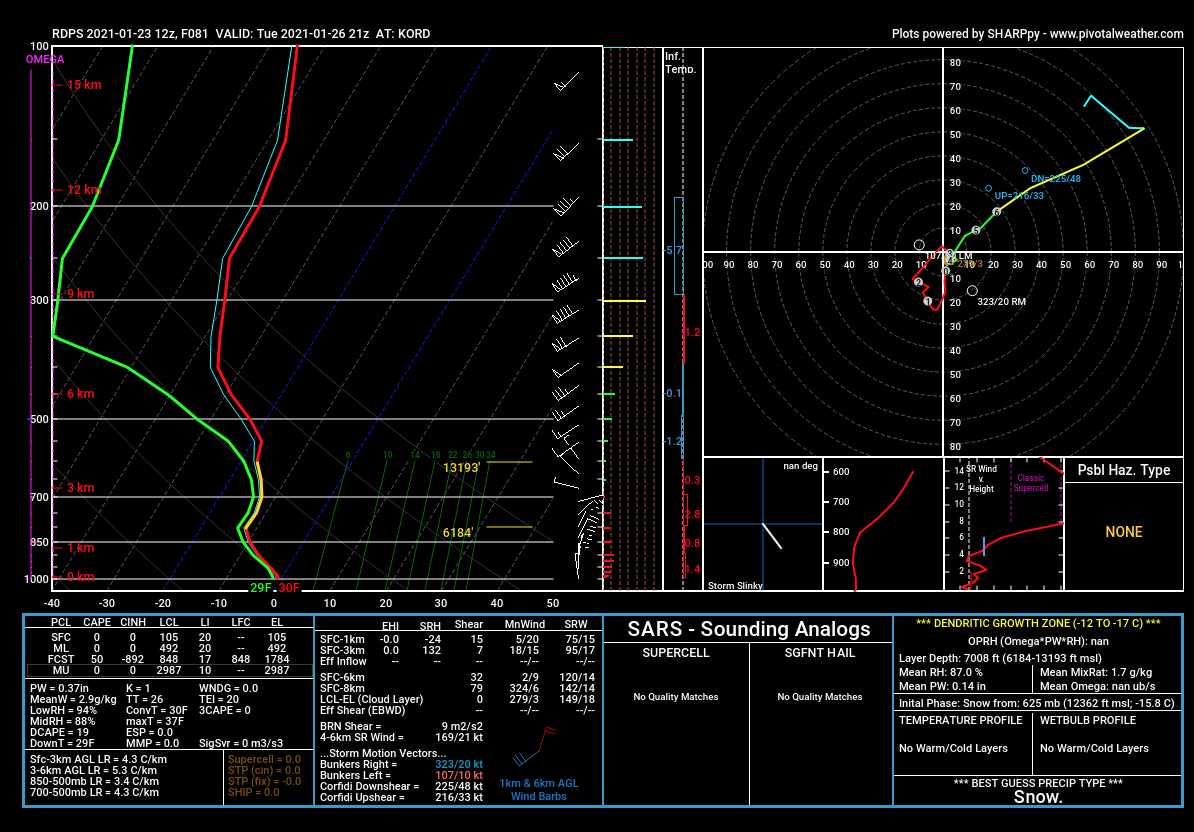
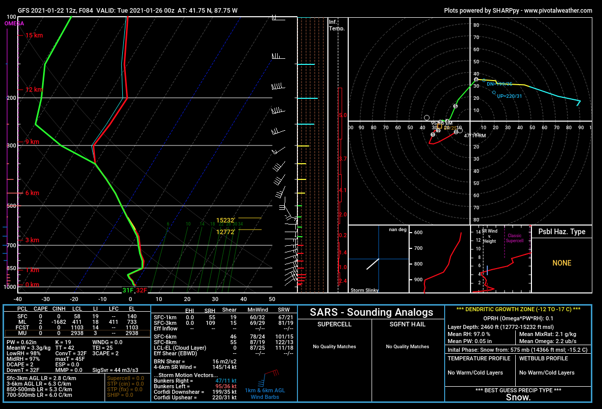
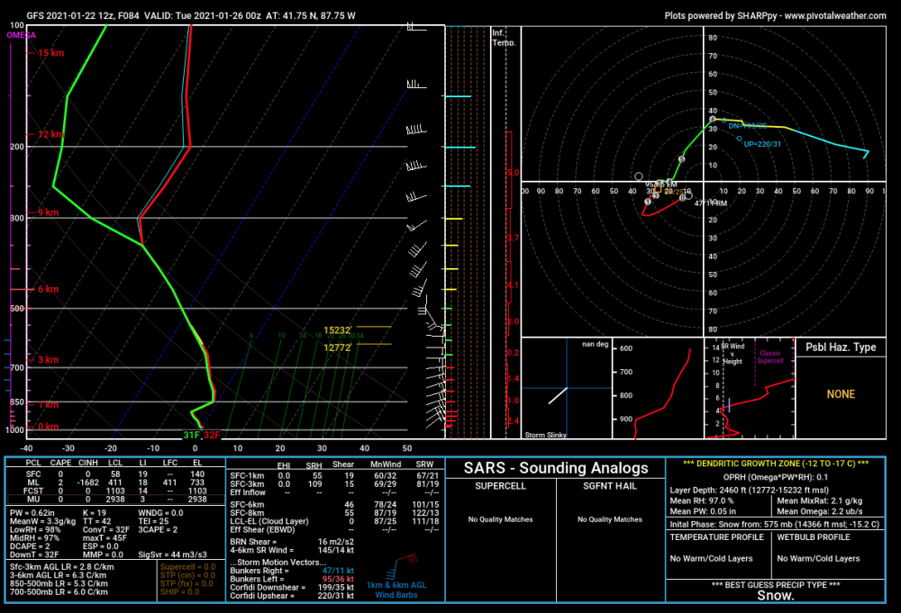
What's also interesting about the synoptic light snows into Tuesday, is that we have steady cold air advection in the lowest 3KM or so with a lengthening fetch over the Lake. This 12Z RGEM sounding for Tuesday afternoon would result in a much deeper DGZ, high-ratio snow and the potential for significant additional accumulations. Most other guidance isn't quite as cold though.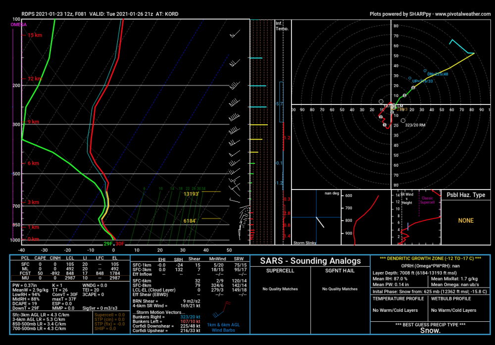
-
It won’t be fully onshore until Sunday morning.
-
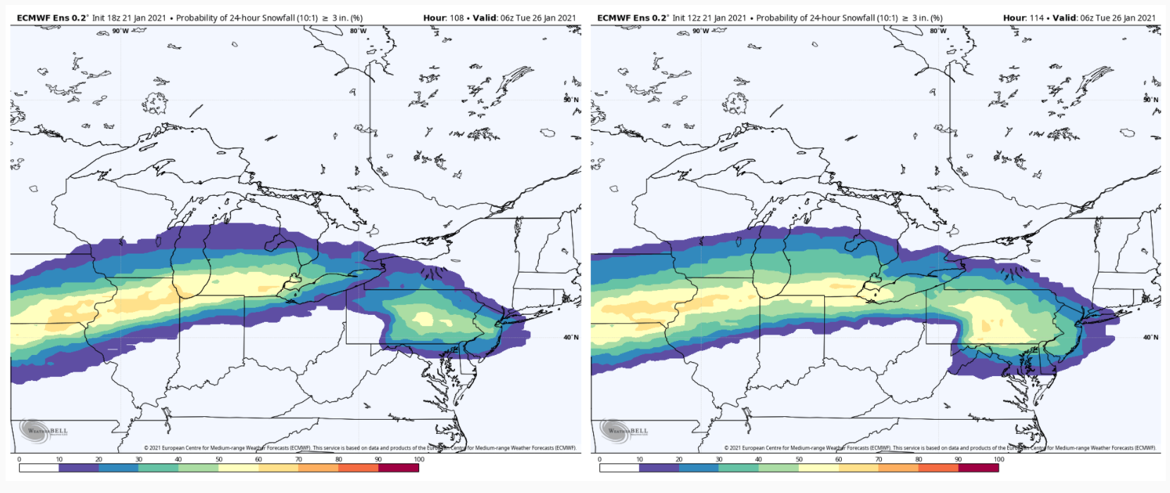
Snow:liquid ratios probably won’t be spectacular given the DGZ is only 100mb deep, strong winds from 700 to the surface and a temp profile flirting w the freezing mark, at least from IL on east. I’d say average 8-12:1. Another reminder that QPF is poorly modeled and often too high (w some exceptions....NAM cold sector for instance).
-
-
With the closing off 700/500 waves and open Gulf, there should be a decent amt of convection w this, even in the cold sector. Lapse rates above 500mb are favorable. Also noticing some guidance showing smaller scale ridge-trough-ridge features at the surface which could be indicative of gravity wave formation. Would rather see the sfc low continue to deepen to believe that, but we’ll see. Also a reminder to all that QPF is one of the most poorly modeled entities.
-
The synoptic pattern for GHD 2 (2015) was not really that similar to this setup. You had a strong vortex over Hudson Bay and ridging in the Southwest, neither of those is true here. Any NAO ridging then was east of Greenland (which also shows how east-based -NAOs are more favorable for big dogs in the Midwest) - here the ridge is over the northwest passages.
-
Fair enough, but they’re all kinda trending toward each other. If you look back 24-48 hours ago, Euro had the heaviest snow in WI while GFS was south of Indy. That drawing was most def not based on one run. I may have short changed IA a bit there due to the limits of what I was drawing with. Could be more E-W oriented as the wave heads NE before being shunted E by the block.
-
For sure, a swath about that width either side is still in the game. Just where I have the higher confidence for now.
-
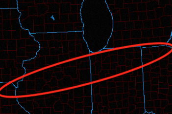
Based on 24 hour trends and 12Z guidance, I'd feel most comfortable in the area below for the swath of heaviest snow. If the block suppresses it any more, you can forget about any lake enhancement in IL. Some hints of colder air Monday night - Tuesday w/ a favorable fetch for true lake effect, but we'll see.
-
I don't know who Joe is, but if anyone on here can provide a scientific, meteorological analysis of how dendritic snow growth would occur with marginal lake effect parameters, I'd be happy to listen.
-
How so?
-
Highly unfavorable for lake effect if you assume the GEFS temp profile is anywhere near the GFS Monday evening. You'd want to see at least -10C between the surface and 850 mb, and it's showing about -5C at the coldest. That's a delta T of about 10C, usually want 15C+ for true lake effect. Lake enhancement due to low level convergence could maybe produce an additional inch lakeside, in my scientific opinion.
-
See probs I mentioned below. You’re taking snapshots that are not accounting for the slower wave. 3” probabilities barely budged but the northern end is lower. So...not really a NW trend is it. Try being more specific with what is trending rather than saying “bump NW” which isn’t really useful to those trying to understand the meteorology of why.

-
Careful using run totals when it’s the sat night-sun wave that is producing more snow. The Mon part did not trend NW. Probs for >3” are lower in southern WI than on the 12Z EPS.
-
It’s also important to point out these short waves rounding the south side of the NAO block are in a data sparse region and will be until the weekend. These go on to make up the MB wave that affects where confluence is, etc. I would normally trust the Euro 4DVAR to catch everything but in this case I’m not sold. Probably the best bet as usual at this range is a blend of current guidance.
-
Yeah the Southwestern shortwave is def slower too. I see a more expansive upper low over MB that is about 60 m deeper too. Best I can tell the confluence would be a hair farther south. I guess my point was based on the MB wave trending stronger and bigger the past few runs. If that trend continues, suppression would probably continue.
-
18Z Euro stronger w the northern stream again. Doesn’t go out far enough but would almost certainly end up farther south than the 12z run. Respect the west-based -NAO?
-
Winter 2020-21 Medium/Long Range Discussion
purduewx80 replied to Hoosier's topic in Lakes/Ohio Valley
Haha nice. Climo says no.
-
As currently modeled there is almost no support for true lake effect snow in IL or IN. Coldest low level temps stay well N in WI.