purduewx80
-
Posts
1,705 -
Joined
Content Type
Profiles
Blogs
Forums
American Weather
Media Demo
Store
Gallery
Everything posted by purduewx80
-
happy birthday to this thread/topic/sh*tshow
-
There are lots of reasons to be hopeful, but it’s somewhat surprising how little chatter there is in here about the B117 (UK) variant, which is estimated to be 60% more infectious and has a 64% higher likelihood of causing hospitalization. Once the variant reaches 50% of new cases, we are expected to see a rise in cases and hospitalizations again. Moreover, kids are catching it at a higher rate and are just as likely to spread it to others. The strain in Brazil sounds as bad or worse, and they are heading into the lower UV season now.
-
Got my 2nd dose of Moderna yesterday. No adverse effects today other than a minor headache when I woke up, which may or may not have been due to the glass of red wine I had last night after work. Several of my co-workers had to get their 2nd yesterday too and did not fare as well, so I’m filling in today. Seems prior infection did reduce the side effects of the 2nd, for me anyway. Can’t speak for the other mass vax sites, but the Kane Co one was exceptionally well run and efficient. There is no shortage of medical workers there monitoring people for anaphylaxis or other reactions - no reason whatsoever to feel unsafe.
-
The Ohio is reaching a crest in the Louisville this weekend....technically minor flooding but still impactful.
-
There are signs on the ensembles (and MJO?) for another dump of cold air into central and eastern North America towards the last week of the month. Of course, the fact that it's several weeks out and that Bust-hard-i is honking that horn gives me reason to doubt it. Guess we'll see.
-
There are even some weather-savvy people I work with who don't understand the differences. Some of this comes down to communication failures, but I also think simplifying things will do wonders as long as it is well-planned and executed. In some ways I liken all of this to the private industry starting to name winter storms. There is a ton of pushback in the meteorological community, but I've seen firsthand how it actually makes it easier to communicate risks in the age of social media.
-
First legit lake breeze for Chicago tomorrow. Should make it well into the 50s early PM before it comes crashing down.
-
Can definitely see the reverse gradient even more now driving to/from work in the suburbs. Lots of grass showing out there but we still have deep piles in the city. Despite most roads being snow-free now, people are somehow still claiming dibs on parking.
-
I've been debating the latter given all the recent news about potentially not needing a second dose if you've already had COVID-19. As with everything else during the pandemic, I doubt CDC will recommend anything based on science for at least several months even as other countries appear prepared to do so. If I'm even more protected now from re-infection than those who never had it and got two doses, why not let someone who needs it more than me have it? I got my first dose about 11 months after having COVID-19. There was some prolonged (~4 days) swelling and soreness in my arm, and I may have had some slight muscle fatigue, but I otherwise had none of the other symptoms reported. I know as of November I still had some anti-bodies from last March, but the study I'm part of didn't divulge exactly how much.
-
ORD up to 40 for the first time since Jan 14th. Models are over saturated in the boundary layer, which means 50 could be in reach tomorrow with the anticipated sun and wind/mixing. Deep snow cover may cap it in the upper 40s.
-
Looking $$ near and north of ~I-80. FGEN could even sneak some 6" amounts in IA/WI. Dynamics easily support swaths of 1-2"/hr given the instability and moisture available.
-
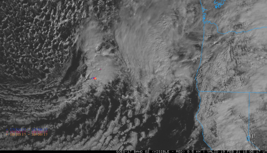
As Ricky has mentioned a few times now, there are some similarities to the Feb 4 system (that produced widespread TSSN). Seeing thunderstorms with it already out over the Pacific, which is a good indicator of the steep lapse rates aloft. The dynamics with this look really good despite the trough being positively tilted, its 60KT LLJ will be tapping into some Gulf moisture, too.
-
Winter 2020-21 Medium/Long Range Discussion
purduewx80 replied to Hoosier's topic in Lakes/Ohio Valley
Halfway decent agreement on the -PNA in the extended. This does not bode well for river flooding since the Gulf will open up for business and the pattern should remain active. Could mean a lot more snow for some, too.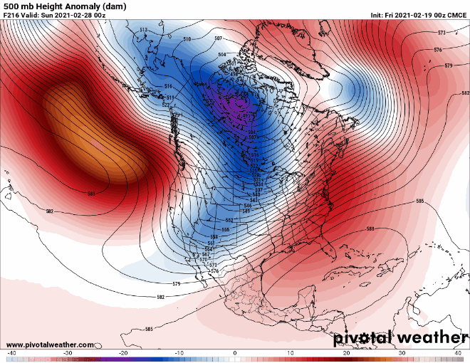
-
More synoptic seeding coming in in an hour or two. Can see it starting on sat/radar over southern LM.
-
Really nice lake enhancement showing up on TORD. Models not doing well. Some may get more than an inch within a couple miles of the lake.
-
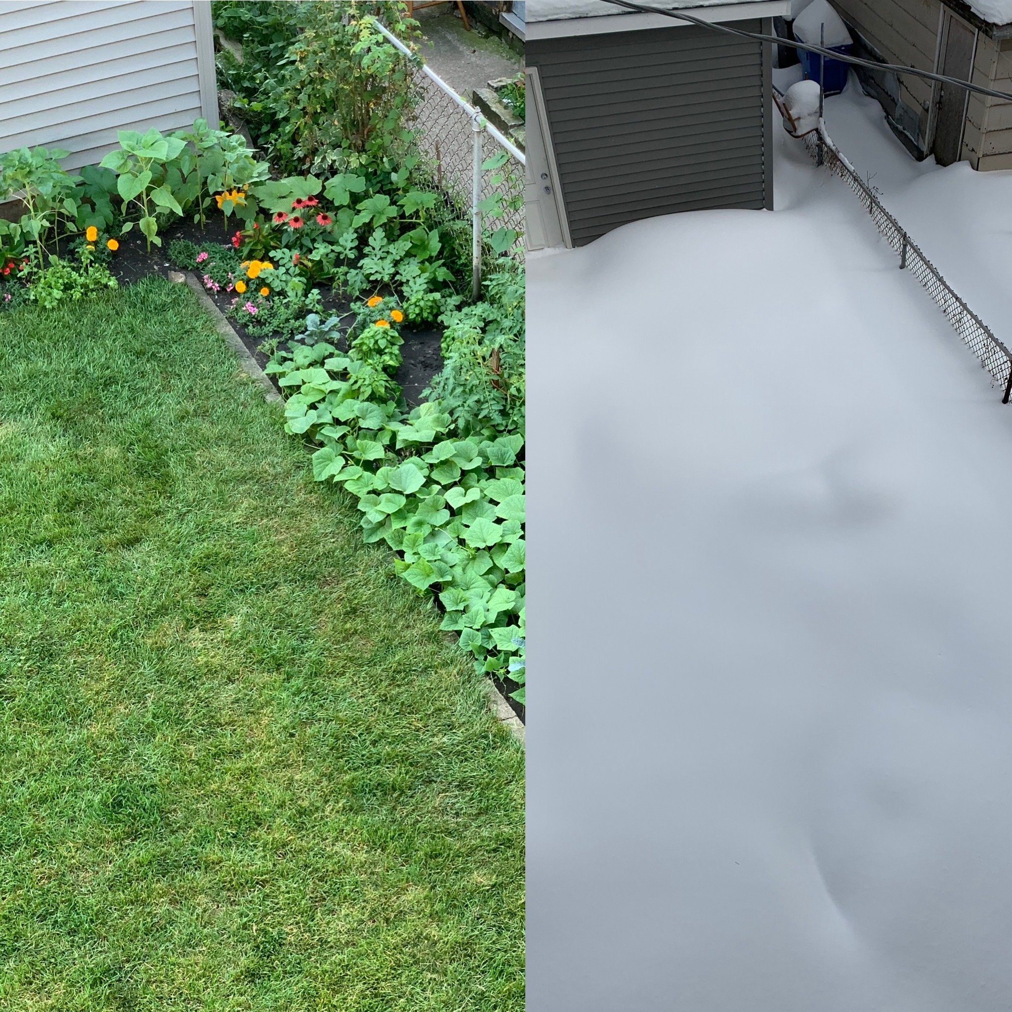
Epic snow depth here now, which I haven’t experienced since living in Madison in ‘07-‘08. No way of knowing exactly how much we got, but there are drifts of 3-4’ in the backyard and piles 5-6’ high along the street. Roads are still pretty meh in the city, 290 was even still partially snow-covered on the drive home this afternoon. Safe to say the perennials are well-protected this year.

-
Been a recent uptick in cases at work that is driving a move back to staffing restrictions. The office has been a bellwether for trends in the national population, so I’ll be curious to see how things shake out the next few weeks.
-
Pretty bummed to be missing out on the absurd rates at home. Hunkered down at a hotel by work so as not to experience the shitshow that will be every highway in the area at 4 AM tomorrow.
-
I called and tried. What a nightmare. “Blowing snow is the obstruction”.
-
Actually some indications of waterspouts in the meso lows over the lake on TMDW.
-
Radar estimating some tops over the lake as high as 10,000’ or 3km. Gives increased confidence in some 2-4”/hr rates today.
-
The 03Z has 13” because of snow w the system later in the week. It’s just over 9” with this system.
-
Some double digit totals already near the lake in IN. One report of 10” in 3 hours.
-
Nothing more predictable than a mby meltdown.
-
Euro came a good bit NW w/ the back edge of precip late Monday (as compared to 12Z). Hi res models are showing the EL close to 2km which is more than enough for the heavy rates you’ve been hinting at, and having the synoptic support tomorrow night and again Monday nights helps guarantee sufficient moisture. My hunch is that LOT is a bit gun shy given the tendency for hi res to overdo LES earlier in the season, but there are a lot more reasons to believe it this round than not, IMO.