purduewx80
-
Posts
1,705 -
Joined
Content Type
Profiles
Blogs
Forums
American Weather
Media Demo
Store
Gallery
Everything posted by purduewx80
-
There are a lot of people affected by the UHI effect, so what we are experiencing is real. It’s also a good thing we have plenty of other climate data to back up what is obvious happening globally.
-
UW would still most definitely have the cooling influence of Mendota and to a lesser degree Monona this early in the season. ARX is also on the higher terrain above the Mississippi, which is why LSE in the valley is warmer. Can’t really explain Duluth since it’s practically on airport property. NWS is surrounded by trees though.
-
This is literally discriminatory thinking. You sound like a terrible boss for people who aren’t like you. https://www.mayoclinic.org/coronavirus-infection-by-race/expert-answers/faq-20488802
-
When I had COVID-19, the back, neck and head pain were like that for over a week. Hope you’re well in short order.
-
LOT leaving central Cook out of the frost advisory was a good call. Never got below 40 here in the UHI.
-
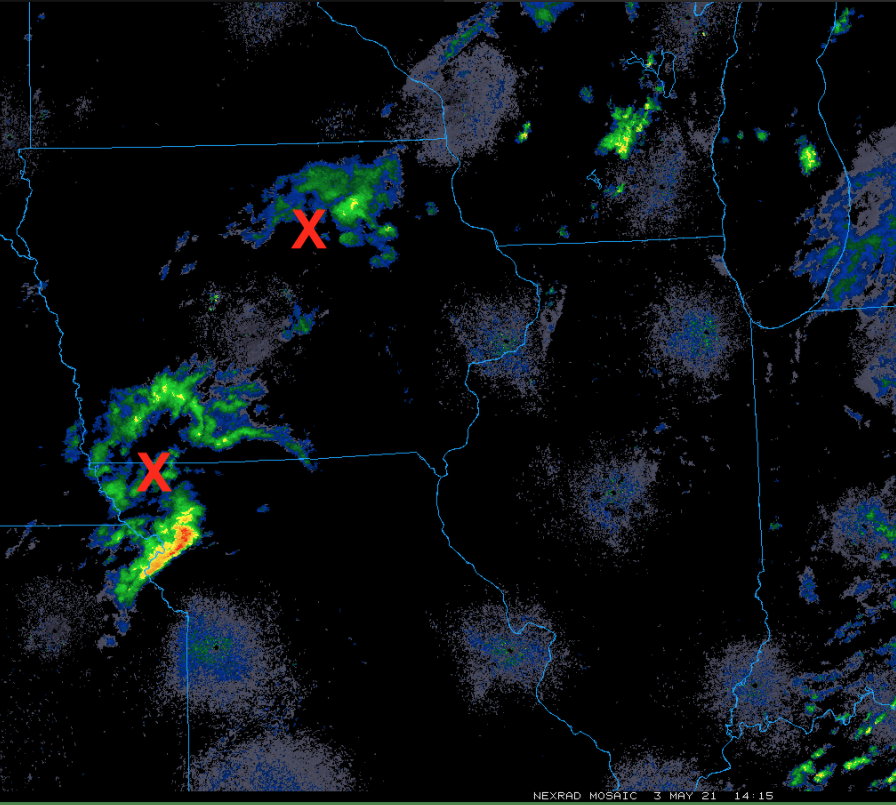
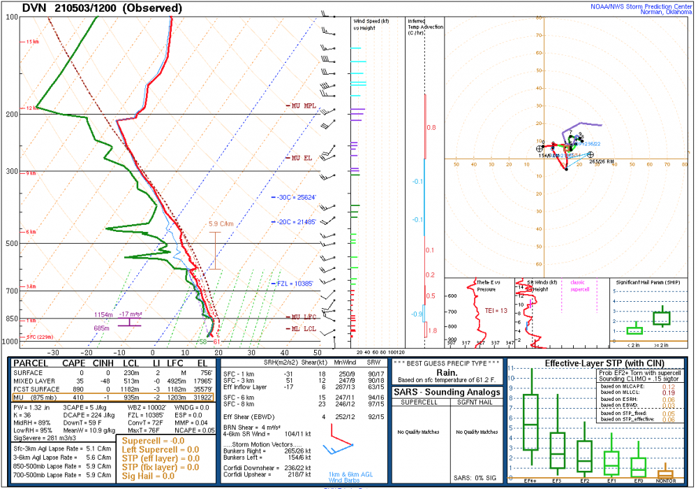
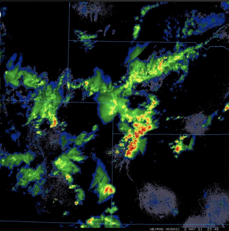
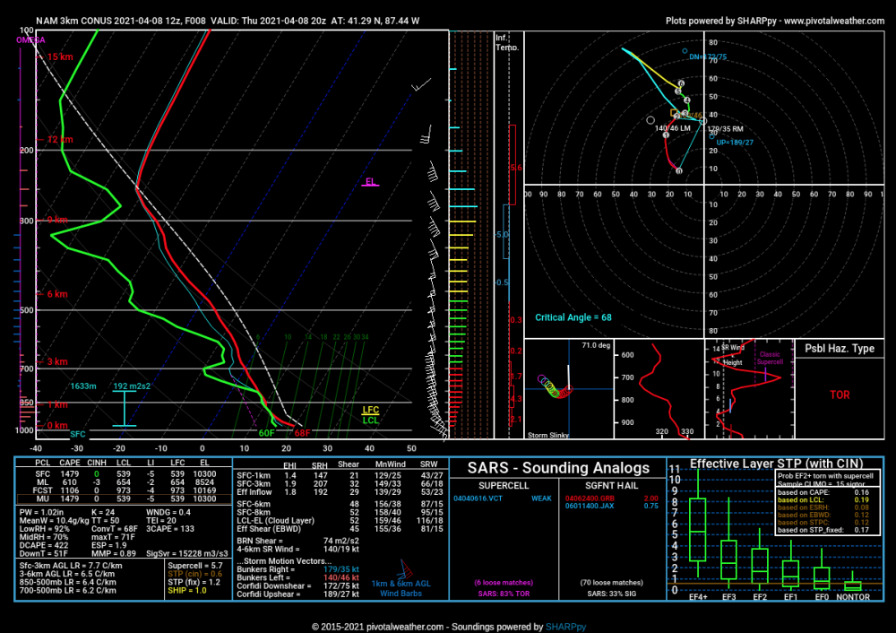
It isn't going to take that much heating to achieve the convective temp seen on local upper air soundings this morning (probably by noon in IA/WI). That convective trigger temp is anywhere from 69-74F (72F on the DVN sounding below). It may not even need to reach that high to get things going with the two MCVs approaching, a number of surface convergence areas and differential heating. Faster mid-level flow is found just S of the NW Missouri MCV and should make it up to about I-80, so that may be the limit to the potential for more organized severe wx. I am personally 100% ok w/ a garden variety storm at this point. Storm motions will not be all that fast so some of us will pick up a prolonged downpour.

-
Should get an MCV or two out of this to help kick things off early tomorrow afternoon and also locally enhance the severe threat. Pretty big timing difference in hi-res and globals. The AM upper low will have to get out of the way to achieve sufficient instability, which seems doable. Curious to see how this interacts with the outflow/front across WI or northern IL too.
-
RGEM nailing it around here today and gets ORD to 86 tomorrow.
-
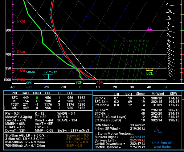
Latest Euro valid at 1PM Wednesday for Aurora: 0-3km lapse rates are 9.6C/km and the equilibrium level is more than cold enough for lightning (threshold is ~-30C). The freezing level is near 2000', but any heavy precip would be just enough to bring snow in the core of any potential convective cells.
-
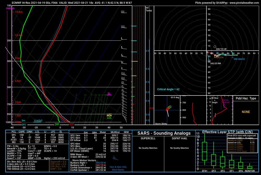
Wherever tomorrow doesn’t deliver, there may be a risk for heavy snow showers Wednesday under the cold core. ECMWF area forecast sounding for LOT’s CWA below - point soundings from it and the NAMs show some potential for TSSN. I believe we had a similar April setup in ~2016 that produced local squalls w lightning and thunder.
-
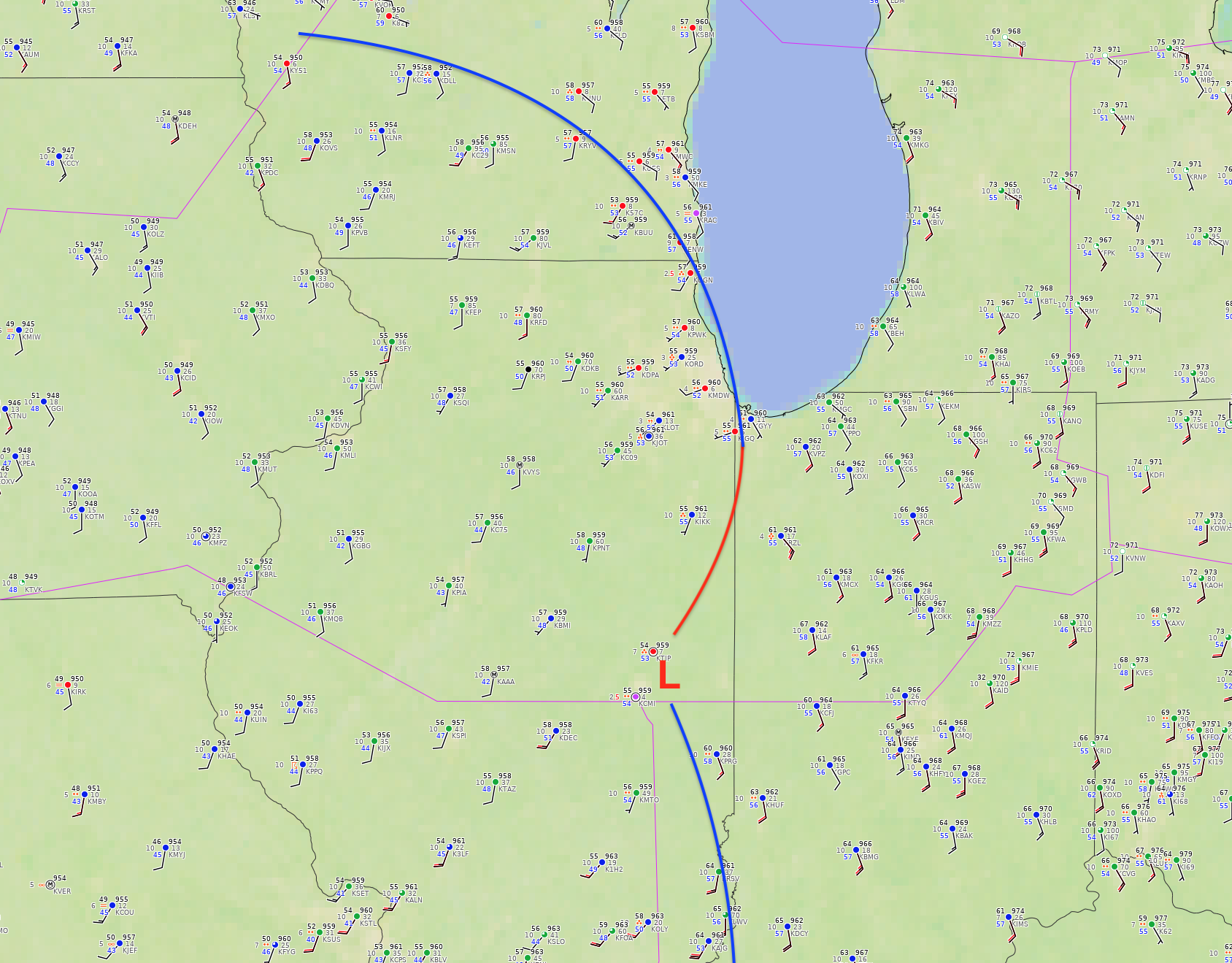
There's a subtle mesolow the HRRR has been hinting at currently in eastern IL. The front has more or less stalled over Newton & Benton counties in IN as that low lifts northwards ahead of a decent s/w trough; it'll probably stall over Lake Co shortly. Will be a decent focus for showers and embedded storms with a heavy rain threat along and to the west of it. Any isolated severe threat will be just east across the rest of IN into SW MI.

-
Perhaps a non-zero mini-sup/tornado threat ahead of the front early this afternoon, where winds stay backed from the SE. Should be some good local downpours given the high PWATs and slow progression of the front. Judging by where the front is currently, the higher threat locally is probably across NW IN into MI. 12Z NAMNEST near the IL/IN border at 3PM:
-
Is it though? https://www.google.com/amp/s/amp.cnn.com/cnn/2021/04/06/health/youth-sports-covid-spread-wellness/index.html
-
Up to 70 at O’Hare, finally. 1st of the year.
-
Getting vaccinated prevents the vast majority of vaccinated people from catching COVID and unknowingly passing it on to others. https://www.cdc.gov/media/releases/2021/p0329-COVID-19-Vaccines.html
-
Oh look. Another racist false equivalency.
-
Stebo was right.
-
this doesn't go nearly far enough in addressing the rampant racism in this thread. do better.
-
Postponed to an as-yet-determined date by the severe weather this week. https://www.noaa.gov/media-release/noaa-to-announce-major-upgrades-to-us-weather-model
-
I'm not pretending anything. This is all well-documented. I see your random internet article and raise you another random internet article with many, many valid counterpoints. https://fivethirtyeight.com/features/why-fewer-black-americans-are-getting-the-covid-19-vaccine-no-its-not-hesitancy/
-
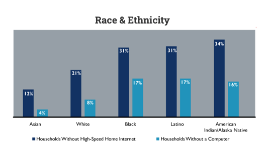
It's far more complicated than that, but your racism is showing loud and clear. Here's some relevant info that's a little dated (2006): Reference: internet, the graph below speaks for itself:
-
Quit living in fear, man.
-
Beware the Ides of March (and into the 16th)
purduewx80 replied to Hoosier's topic in Lakes/Ohio Valley
Driving west out of the city to Aurora was wild. Went from everyone speeding and cops pulling people over to a complete whiteout in only a few minutes. All snow until Aurora where there are a few pingers mixing in. -
Beware the Ides of March (and into the 16th)
purduewx80 replied to Hoosier's topic in Lakes/Ohio Valley
pretty shocking to see after the recent warmth. guess the dry/cold air feed from the east means business. -
Beware the Ides of March (and into the 16th)
purduewx80 replied to Hoosier's topic in Lakes/Ohio Valley
Peoria reporting 0.15" of ice accretion since 12Z and 0.06" in the last hour. 0.11" at CMI since 12Z. KPIA 151454Z 09017G28KT 4SM FZRA BR OVC050 00/M02 A3007 RMK AO2 PK WND 08028/1453 SLP188 P0013 60052 I1006 I3015 T00001022 50010