

midatlanticweather
-
Posts
4,926 -
Joined
-
Last visited
Content Type
Profiles
Blogs
Forums
American Weather
Media Demo
Store
Gallery
Everything posted by midatlanticweather
-
Euro and GFS Now look to get us a taste of fall again at the end of next week. At least some below normal temps for a bit! Hopefully that holds. GFS has been advertising it (and way overdoing it at times) and it now looks possible!
-
12Z GFS is bizarre in the long range! LOL!
-
Has another heavy shower come through around 11pm. Total from both is exactly 0.70... Crazy to have had exactly 0.30 and then 0.40 from two storms.. What are the chances? Good night all!
-
Wow! These storms put out a lot of rain quickly! Had .30 inches in less than 15 minutes! Buckets! Let up now.
-
La La Land keeps giving a small hope of some, probably brief, fall temps. Euro went a little excited with a mid-Country cooler dip! We will see - looking for persistence to see how well we can trust these models for the long-range.. My guess... we trend warmer than cooler. GFS was not quite as excited as it was at one point yesterday.
-
Super Long range GFS had another taste of fall.. Lala land. Euro says.. Nope
-
The Long range keeps looking toasty! Upper 80s and even some 90s. False fall is leaving us.
-
0.65 from this system.. That is a good amount... I was expecting less, but happy to have it! Came at the right time too for great sleep... until the massive strike that scared my dog to death at 2 am! I had a friend that would not sleep the rest of the night! It was super loud, so I do not blame her!
-

2021 Atlantic Hurricane Season Tracking Thread
midatlanticweather replied to WxWatcher007's topic in Mid Atlantic
NOPE! Tropical Storm Mindy! -
2021 Atlantic Hurricane Season Tracking Thread
midatlanticweather replied to WxWatcher007's topic in Mid Atlantic
91L is TD13.. advisories start at 5pm ET -
Doh!
-
What an amazing day!!! Weather is awesome
-
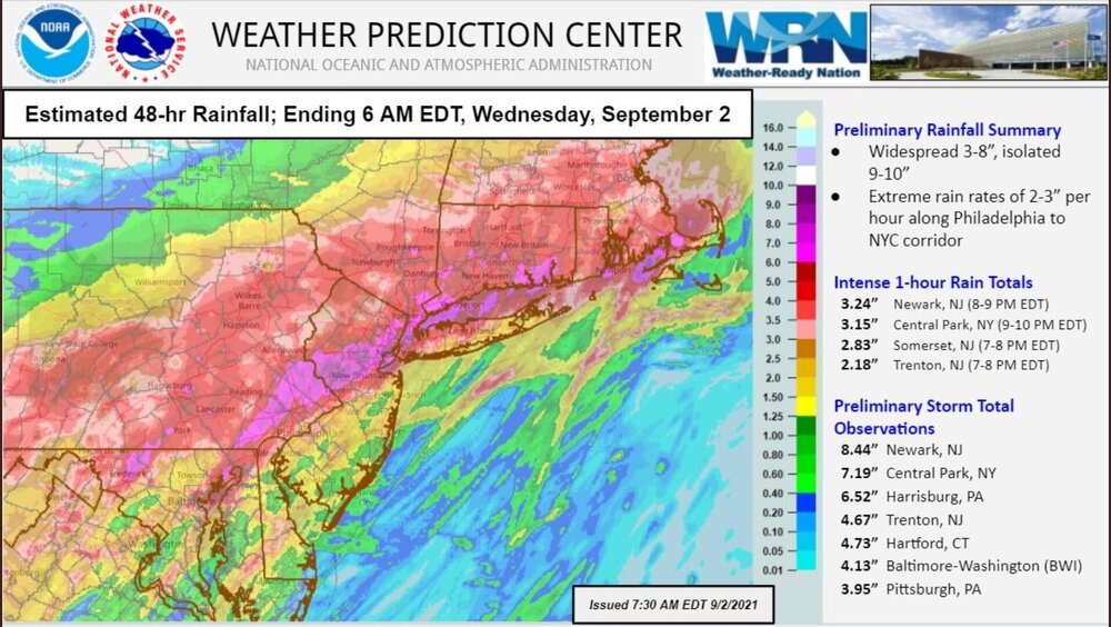
Sorry if this is a repeat! NOUS41 KPHI 021835 PNSPHI DEZ001>004-MDZ012-015-019-020-NJZ001-007>010-012>027-PAZ054-055- 060>062-070-071-101>106-030645- Public Information Statement National Weather Service Mount Holly NJ 235 PM EDT Thu Sep 2 2021 ...4 CONFIRMED TORNADOES SO FAR... ...DAMAGE SURVEYS CONTINUE... The National Weather Service office in Mount Holly, NJ continues to conduct several storm surveys this afternoon, focused on portions of Chester, Montgomery and Bucks counties in PA, and Salem, Gloucester, Burlington, Mercer and Somerset counties in NJ. The surveys are in relation to the severe thunderstorms that moved through the area on September 1, 2021. Some Preliminary Tornado Information... 1) Mullica Hill, NJ area (Gloucester County): Confirmed tornado. 2) Fort Washington/Upper Dublin Twp to Horsham Twp, PA (Montgomery County): Confirmed EF-2 with estimated peak winds up to 130 mph. 3) Edgewater Park, NJ (Burlington County) to Bristol, PA (Bucks County): Confirmed tornado. 4) Oxford, PA (Chester County): Confirmed tornado. Additional information, as it becomes available, will be sent via Public Information Statements and also posted on our social media platforms. The storm survey information will also be available on our website at http://www.weather.gov/phi
-
2.74" total here. Less than a mile away had an inch or so more.
-
You know in winter storms I would have been upset because we did not maximize on the possibility, but thankful we did not.
-
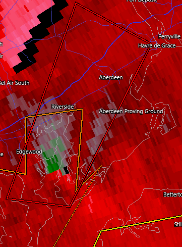
Another Tornado warning in Edgewood! SHEESH!
-
-
Was this posted. Pretty much in line with what people said. Risk is more east!
-
Just shy of 2 inches today. The little line was a bit gusty and briefly heavy with rains. More showers coming this way.
-
-
Is that something south of Boyce (east of Stephens City)? Am I trying too hard?
-
-
And it begins!
-
Oh yes. My ceo called me when he wanted to go golfing in an area so I could get him a detailed forecast. Fortunately, was usually easy, but unnerving to have him call me directly


