Albedoman
-
Posts
1,321 -
Joined
-
Last visited
Content Type
Profiles
Blogs
Forums
American Weather
Media Demo
Store
Gallery
Everything posted by Albedoman
-

E PA/NJ/DE Spring 2025 Obs/Discussion
Albedoman replied to PhiEaglesfan712's topic in Philadelphia Region
Blue mts deztroyed storms again tonight. Forecast is becoming doubtful now -
E PA/NJ/DE Spring 2025 Obs/Discussion
Albedoman replied to PhiEaglesfan712's topic in Philadelphia Region
Missed again tonight. Had to water-Its been a long time since I had to water a garden on the first day in May. The Blue Mts are absolutely destroying every cell that comes near them. Just incredible. -
E PA/NJ/DE Spring 2025 Obs/Discussion
Albedoman replied to PhiEaglesfan712's topic in Philadelphia Region
OK Mt Holly, what do you guys have to say about this 40 degree diurnal temp change today? Woke up at 38 degrees this morning with a projected high of nearly 80 degrees? Wow have not seen this range in temps in a 12 hour time frame in a very long time on a nice day. Definitely living back in the CA Mojave desert environment in eastern PA from my younger days. -
E PA/NJ/DE Spring 2025 Obs/Discussion
Albedoman replied to PhiEaglesfan712's topic in Philadelphia Region
sorry, this song is not the same for my generation. here is the original song which was a top ten song and was played on foldgers coffee commercials. -
E PA/NJ/DE Spring 2025 Obs/Discussion
Albedoman replied to PhiEaglesfan712's topic in Philadelphia Region
OMG what a utter failure. Severe thunderstorm warning issued for Lehigh county-- all I got was a light shower of less than .05. Talk about a fast disintegrating squall line. As soon as it hit the Blue Mts, it was done for. Totally unbelievable. It just does NOT want to rain anything harder than a light shower right now. It was just enough to make the pollen stick like concrete on the cars. Car washes are going to love this tomorrow. -
E PA/NJ/DE Spring 2025 Obs/Discussion
Albedoman replied to PhiEaglesfan712's topic in Philadelphia Region
35+ constant winds like this are really drying out the underbrush big time again. Had only .20 at my house. As tree leaf out continues in huge strides in the next few weeks, no rain means that some streams and surface ponds will be dry by mid-May in our area as any ground water is literally vacuumed out of the soil horizons from no rain and leaf out. Then you will hear the people talk in the media about how this drought never really went away in late March and still exists when their favorite fishing spot goes dry and private wells have to be re-drilled deeper. I see no substantial Gulf moisture influence with 80 degree temps in the next two weeks in our area for heavy rainfall to be forecasted (over an inch). This spells real trouble for us. THIS VERY PROGRESSIVE WEATHER PATTERN JUST WILL NOT STOP. Cold fronts continue to stall out in the midwest and mid south every 2-3 days, dumping copious amounts of rain with thunderstorms and then for some stupid reason race across PA in 24 hours with continuing dying t - storms, with moisture availability gone in a stable air mass, no convective issues and the precip becomes sparse with light showers/drizzle. But the real big issue are the winds behind these fronts being absolutely crazy like tonight. I have had nearly 50 mph wind gusts. Guess will have to wait for Memorial Day weekend to be rained out, as we usually get a stalled out storm pattern to develop by this time. -
E PA/NJ/DE Spring 2025 Obs/Discussion
Albedoman replied to PhiEaglesfan712's topic in Philadelphia Region
My answer to you sir---- LMAO -
E PA/NJ/DE Spring 2025 Obs/Discussion
Albedoman replied to PhiEaglesfan712's topic in Philadelphia Region
yep I knew it was some knucklehead that I said a few days ago. Hope he now has to pay for this catastrophe too to the county (and not just serve time for arson), municipalities and other govt entities that are fighting this fire including the fire companies time and equipment. He will be broke. -
E PA/NJ/DE Spring 2025 Obs/Discussion
Albedoman replied to PhiEaglesfan712's topic in Philadelphia Region
Your italicized comments were not necessary- only to add insult to your previous remarks. I am sorry feel this way. You seem to have a pattern of doing this on other forums too. Anyway you stated the NJ fire was contained in NJ- you could not be more wrong see link below this morning. As far as as fires in the NJ pine barrens as a necessary part of ecology- the Pine Barrens does NOT have the same climate regime as S California. I lived in S. California for ten years and personally dealt with my own brush wildfires. If it they did have the same yearly climatology, S NJ EMS would be better prepared for such a major fire as the one today. Most likely this fire was caused by some knucklehead burning winter debris and not by natural causes like lightning. The Pine Barrens also do not have highly flammable chaparral type vegetation with 18 in of rain per year, just dense evergreen trees and typical underbrush found in our area with 40 in of rain a year. Large wild fires are not normal. https://www.nbcphiladelphia.com/news/local/jones-wildfire-ocean-county-new-jersey-ocean-township-lacey-township-barnegat-township/4166736/ -
E PA/NJ/DE Spring 2025 Obs/Discussion
Albedoman replied to PhiEaglesfan712's topic in Philadelphia Region
After being criticized by an individual for not taking a chill pill and for saying the mulch fire was major fire and that I was blowing the fire possibilities out of proportion with the current drought in the last few days, two so called non-major wildfires are still going crazy. Jim Thorpe area over 500 acres and now another non major fire in southern NJ. All I hear now is crickets at my house. Also Mike Gorse, I must apologize to you and your staff as I did not mean any disrespect toward you or your staff at MT Holly. I am really frustrated with this crappy weather pattern we are stuck in for the past 9 months and did not mean to take it out toward MT Holly staff. Many of the old weather hobbyists have to be as frustrated as I am too as these daily 20-30 mph Santa Ana type winds with extreme diurnal temp ranges and no Gulf of America moisture source for storm convection which has basically has been gone for nearly a year now. I am also hoping a special weather statement will be issued that considers the under-stories in the woods and nearby brushy fields are extremely dry right now regardless of any rain we received two weeks ago. The dry warm winds are sure not helping as evident by these fires. Thanks https://www.foxweather.com/extreme-weather/jones-road-wildfire-new-jersey-shore-smoke-evacuations https://www.inquirer.com/news/pennsylvania/jim-thorpe-pennsylvania-wildfire-20250422.html -
E PA/NJ/DE Spring 2025 Obs/Discussion
Albedoman replied to PhiEaglesfan712's topic in Philadelphia Region
When the mulch pile serves 35000+ residents and takes out a fire company for a few days, yes it is a mafor fire issue for a volunteer fire company and the municipality -
E PA/NJ/DE Spring 2025 Obs/Discussion
Albedoman replied to PhiEaglesfan712's topic in Philadelphia Region
C'mon MT Holly wake up. Here is another major fire this morning in Lower Macungie. Township mulch pile on fire. -
E PA/NJ/DE Spring 2025 Obs/Discussion
Albedoman replied to PhiEaglesfan712's topic in Philadelphia Region
what BS is this? I am wide awake because it so warm with the windows wide open. At 4:00 am it is 70+ degrees outside here in Macungie. 55 degree low doubt we ever reach it.. However at Towanda PA, it is sitting at 46 degrees. Cold front?, why yes. Precip with this cold front - usually a squall line of heavy showers in late April by a cold front with a 24 degree difference in less than 125 miles- not a drop of rain to be found. Winds- of course 20+ mph. Mt. Holly, be prepared for real nice fire condition's on Sunday for our area. This is definitely not April weather- more like late October weather. -
E PA/NJ/DE Spring 2025 Obs/Discussion
Albedoman replied to PhiEaglesfan712's topic in Philadelphia Region
Swing and a miss strike 3. Renegade cell heading fo md. The drought lives on as the blue mtn winds kick up again tomorrow. -
E PA/NJ/DE Spring 2025 Obs/Discussion
Albedoman replied to PhiEaglesfan712's topic in Philadelphia Region
Big brush fire near jim thorpe this afternoon because of the dry understory. We really need more rain..... dry winds today were ideal for fires. All rain north of scranton this evening. Not looking good for the week too. Back into dry weather again. -
E PA/NJ/DE Spring 2025 Obs/Discussion
Albedoman replied to PhiEaglesfan712's topic in Philadelphia Region
we need some decent rain today, otherwise it looks pretty sparse the next week or so. The 70-80 degree temps with these blistering santa ana type chinook winds have dried out the soils pretty damn well the last few days. To add injury to insult, the leafing out of trees now is sucking the living crap out of available soil moisture again, thus the local stream base flows are way below normal for this time of the year in the LV. -
E PA/NJ/DE Spring 2025 Obs/Discussion
Albedoman replied to PhiEaglesfan712's topic in Philadelphia Region
please god no more winds. we have had our share the past 6 months. So many limbs in the yard the last few days. Wind chills today were also brutal for April. -
E PA/NJ/DE Spring 2025 Obs/Discussion
Albedoman replied to PhiEaglesfan712's topic in Philadelphia Region
The south mountairange and bear creek ski resort elevation makes a huge difference in these type of events, Alburtis zip is closest to the elevation of Bear Creek -- 1500 ft + I a escaped with 1.5 in up on the ridges 2+ is easily attainable at nearly 1500 ft. -
E PA/NJ/DE Spring 2025 Obs/Discussion
Albedoman replied to PhiEaglesfan712's topic in Philadelphia Region
for those who have not seen snow south of the LV the last 45 days- here is what it looks like. LOL This was after 8 AM and everything was starting to melt after being covered except the streets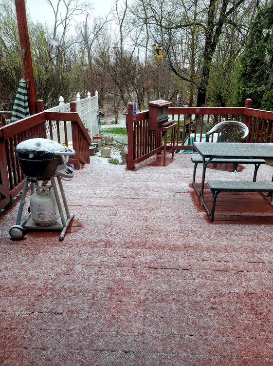
-
E PA/NJ/DE Spring 2025 Obs/Discussion
Albedoman replied to PhiEaglesfan712's topic in Philadelphia Region
less than .5 of snow. Flakes this morning were like pancakes. Received needed rain however 1.10 in. Going into the next week with much needed moisture for tree leaf out. Feel good that the drought is going bye bye if this keeps up by the end of the month. Just bring on the 70's now. Want to turn off the heater. Cloudy 40-50 degree days raise the utility bills for sure. -
E PA/NJ/DE Spring 2025 Obs/Discussion
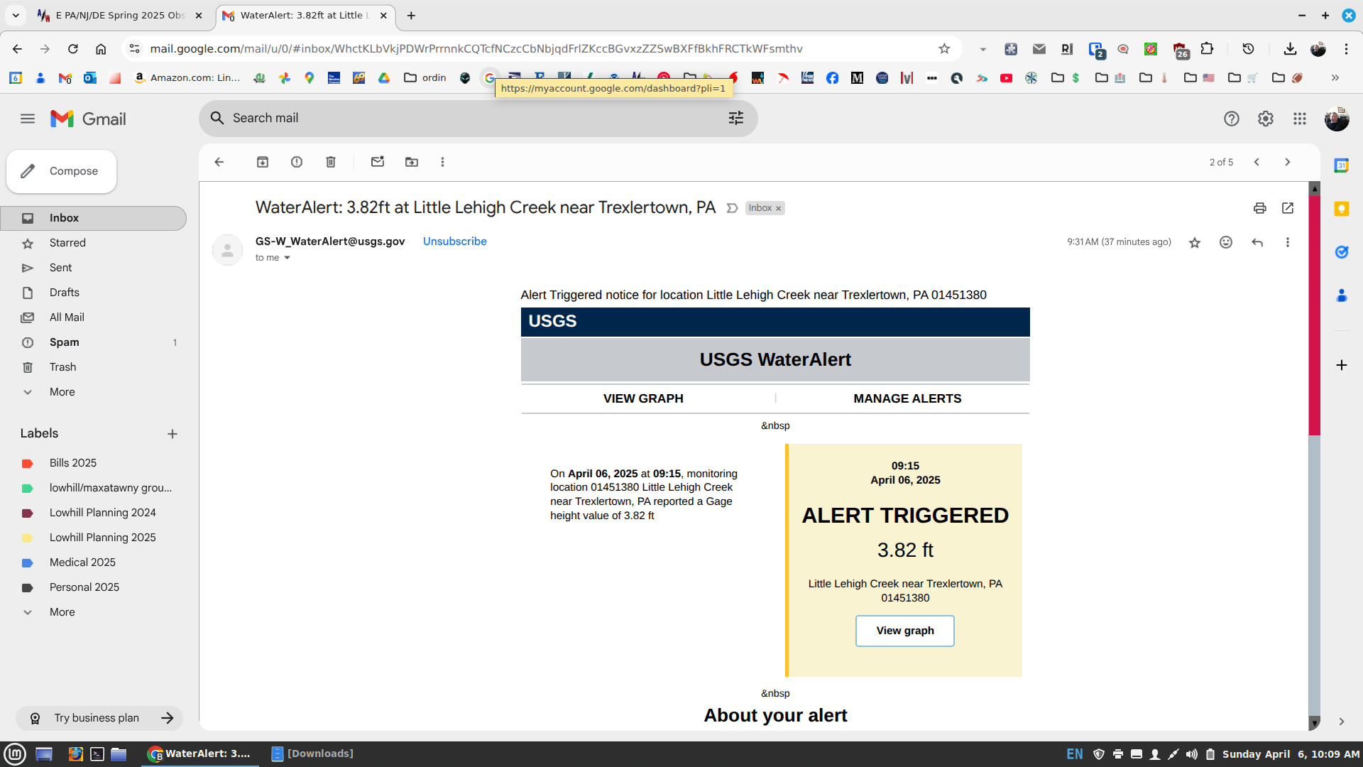
Albedoman replied to PhiEaglesfan712's topic in Philadelphia Region
The precip was really beneficial to the Little Lehigh Creek watershed. I just received my first USGS gauge flood alert on the Little Lehigh at RT 100 this year. My personal alerts are calibrated to when the stream jumps out of it banks, which visibly it has. Once it gets to around 4.5 ft, Spring Creek Rd is completely underwater. The USGS staff from state college and myself have successfully calibrated this new telemetry digital gauge over the last 2-3 years for issuance of flash/flood warnings in our area. Thats why I am called the drought guy. LOL
-
E PA/NJ/DE Spring 2025 Obs/Discussion
Albedoman replied to PhiEaglesfan712's topic in Philadelphia Region
1.35 here in LMT. First time since New Years day that I have seen the Little Lehigh at bank-full and running muddy this morning. Not a good day to trout fish for sure. The headwaters of the Little Lehigh finally received some decent precip. Put a real nice dent in the drought conditions for the entire watershed. Waiting for the snow and graupel for tomorrow. -
E PA/NJ/DE Spring 2025 Obs/Discussion
Albedoman replied to PhiEaglesfan712's topic in Philadelphia Region
dusting of snow with graupel a good bet as cold air advection works in. Best chance of frozen precip since Feb LMAO -
E PA/NJ/DE Spring 2025 Obs/Discussion
Albedoman replied to PhiEaglesfan712's topic in Philadelphia Region
the thundershower I hoped for. maybe more later -
E PA/NJ/DE Spring 2025 Obs/Discussion
Albedoman replied to PhiEaglesfan712's topic in Philadelphia Region
Lagavulin. Neat. Clear alcohols are for rich women on diets.” The story goes that when coming up with characters for his hit sitcom 'Parks and Recreation', creator Michael Schur snuck in one autobiographical detail into the grouchy but loveable protagonist, Ron Swanson – his love of Lagavulin whisky.