Albedoman
-
Posts
1,321 -
Joined
-
Last visited
Content Type
Profiles
Blogs
Forums
American Weather
Media Demo
Store
Gallery
Everything posted by Albedoman
-
 Another abysmal cold spell top remind us of this lackluster winter- 2-3 days after Ground Hogs day with virtually no snow on the ground again- the pity hits just keep coming this winter. Gotta talk about this last gasp of winter since the rest of February appears to be toasty. Even the ground Hog has a message for all of us after this cold outbreak:
-
E PA/NJ/DE Winter 2022-2023 OBS Thread
Albedoman replied to Ralph Wiggum's topic in Philadelphia Region
I am actually shocked at the image from the 18Z GFS run i just observed below. I have been alive for 64 years, lived in Wi, Tn, Ca and pretty much traveled throughout the country. Yet, it appears I will actually finally experience a great plain weather scene next weekend where the temps are near zero with no snow on the ground. I say good because every dam nuisance bug will be killed after that cold spell on our area for sure, including the ash borer, box elders, stink bug, lantern fly and maybe some mosquitoes to boot. Finally something good to talk about in the pattern. I will be looking forward to less bugs -
E PA/NJ/DE Winter 2022-2023 OBS Thread
Albedoman replied to Ralph Wiggum's topic in Philadelphia Region
This is not only bad- it is just outright disgusting. One run for the records. The LR thermals indicate us back into the 60's after the end of next week. This year will be aka "The little winter season engine that could" https://www.prindleinstitute.org/books/the-little-engine-that-could/ -
E PA/NJ/DE Winter 2022-2023 OBS Thread
Albedoman replied to Ralph Wiggum's topic in Philadelphia Region
OMG. I have to wipe the tears out of my eyes from laughing so much. The point forecast for my house tonight is literally a joke. No sunshine until Thursday. I edited it for your enjoyment too ++++++++++++++++++++++++++++++++++++++++++++++++++++++++++++++++++++++++++++++++++++++ Tonight Increasing clouds, with a low around 30. South wind 5 to 10 mph. Saturday Increasing clouds, with a high near 46. West wind 10 to 15 mph. (So it is just cloudy enough for you in the LV yet so we will keep increasing the clouds until it is?) Saturday Night Mostly cloudy, with a low around 31. South wind around 5 mph. Sunday A slight chance of rain and snow showers before 10am, then a chance of rain showers. Mostly cloudy, with a high near 47. Southwest wind 5 to 15 mph. Chance of precipitation is 30%. Little or no snow accumulation expected. (Yep it is true, snow is not allow to accumulate for longer then 8 hours in the LV before melting away) Sunday Night A slight chance of showers before 1am. Cloudy, with a low around 34. Southwest wind 5 to 15 mph becoming northwest after midnight. Chance of precipitation is 20%. Monday Mostly cloudy, with a high near 45. Monday Night Mostly cloudy, with a low around 29. Tuesday Mostly cloudy, with a high near 36. Tuesday Night A chance of snow after 1am. Partly cloudy, with a low around 25. Chance of precipitation is 40%. Wednesday A chance of snow showers, mixing with rain after 10am, then gradually ending. Partly sunny, with a high near 36. Chance of precipitation is 40%. Wednesday Night Mostly cloudy, with a low around 23. (whoopee -- ice to deal with on my car as the melted snow freezes- my favorite) Thursday Partly sunny, with a high near 33. (Hot dam-- what the hell is that yellow ball in the sky that I see today?) Thursday Night Partly cloudy, with a low around 17. Friday Sunny, with a high near 33. (Finally all day sunshine but no again snow on the ground and now it is below freezing for a high -- typical screw job) -
E PA/NJ/DE Winter 2022-2023 OBS Thread
Albedoman replied to Ralph Wiggum's topic in Philadelphia Region
this says it all
-
E PA/NJ/DE Winter 2022-2023 OBS Thread
Albedoman replied to Ralph Wiggum's topic in Philadelphia Region
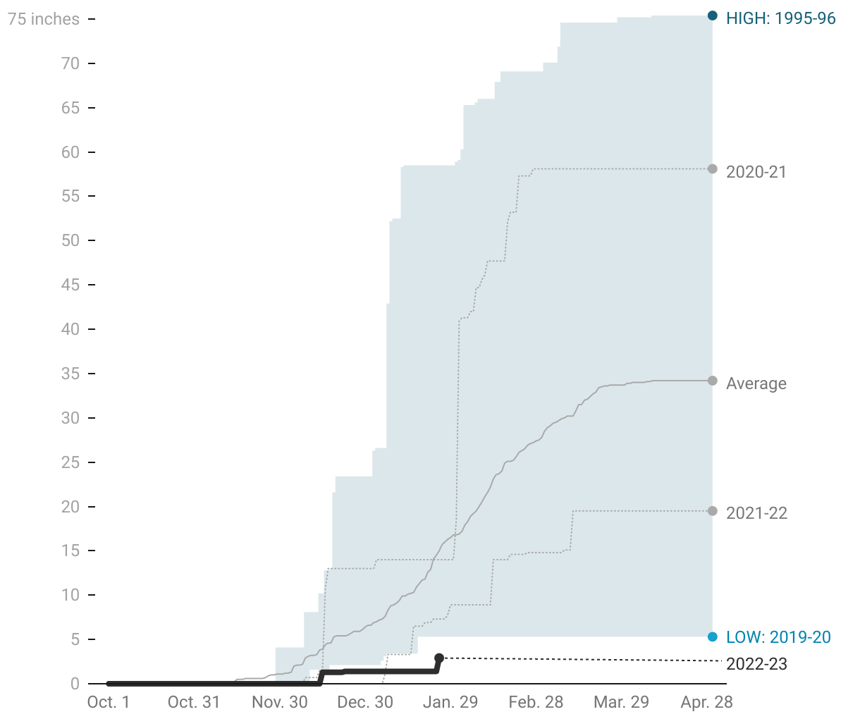
Yearly snowfall amounts in LV and where we stand this year. Pitiful as the snow we received yesterday is already gone. As far as I am concerned, its still a shutout as no snow has been on the ground for the entire day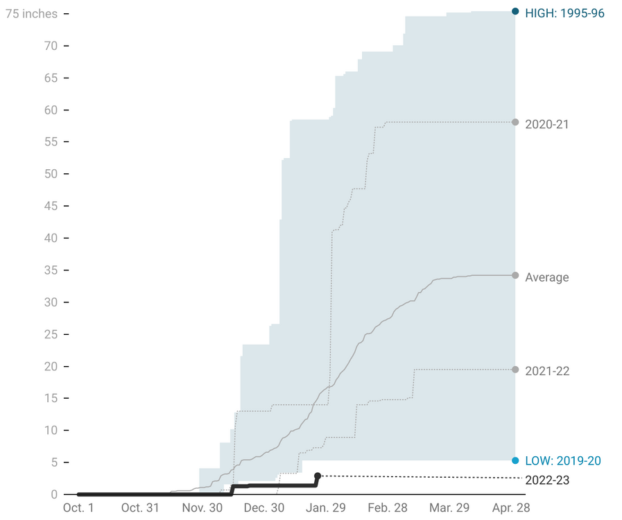
-
E PA/NJ/DE Winter 2022-2023 OBS Thread
Albedoman replied to Ralph Wiggum's topic in Philadelphia Region
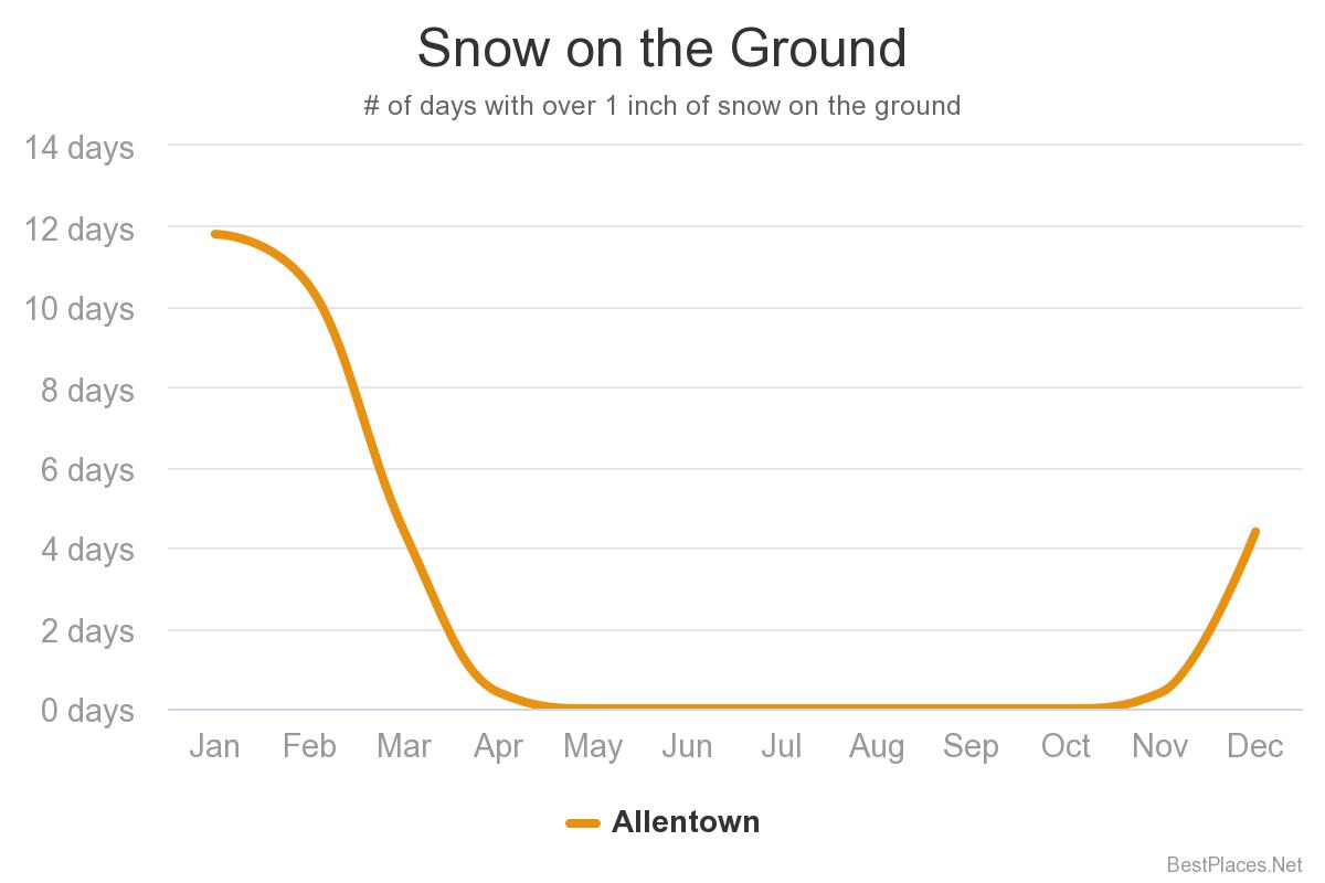
I tell you what a pathetic winter is. When it does actually snow nearly 3 inches and the snow cannot even stay on the ground for longer than 8-12 hours. The snow cover is basically gone in the LV area. We have had nearly 4 inches of snow this wonderful year and none of it has been on the ground 12 hours later. That should count for jack shite for snowfall totals Its like pulling the rug out. Somebody please provide us posters who like a good winter season with info on when the last snow that was on the ground for longer than three days in the LV or SE PA. Otherwise as far as I am concerned I am afraid this winter season is over even with yesterdays snow as I see no significant snow being on the ground longer than 24 hours on any model run period in the foreseeable future. In summation, winter is not a true winter unless snow is on the ground for longer than a week.
-
E PA/NJ/DE Winter 2022-2023 OBS Thread
Albedoman replied to Ralph Wiggum's topic in Philadelphia Region
Rephrase Please "what could possibly go right!" LMAO -
E PA/NJ/DE Winter 2022-2023 OBS Thread
Albedoman replied to Ralph Wiggum's topic in Philadelphia Region
wow, finally some pancake snowflakes an hour ago here in Macungie. Looks real hopeful on Wednesday as the Nam and Euro all agree on 4+ in snow for the LV 48 hours out. Expect at least a WSW for our extreme northern counties in our area tomorrow. -
E PA/NJ/DE Winter 2022-2023 OBS Thread
Albedoman replied to Ralph Wiggum's topic in Philadelphia Region
this video clip is painful for me watching the models runs lately and then finally waiting for a good snowstorm. LOL. This movie is demonstrates the epitome of how it rains primarily in Philly but snows in the NW burbs in the opening scene -
Central PA Winter 2022/2023
Albedoman replied to Blizzard of 93's topic in Upstate New York/Pennsylvania
For better or worse. Well she apparently does not know what that means. My god, going blind and not breathing for a parent is terrifying in any situation and especially to the children and grandchildren. Moving your mother to PA nursing home would be the best option if you want to save your marriage. But if the wife says no, its time to hit the road and live with Mom until the end. I know my wife would support either one of our parents no matter the situation. We miss them. You wife's parents still alive or have they passed and she simply does not care? So Sorry -
Central PA Winter 2022/2023
Albedoman replied to Blizzard of 93's topic in Upstate New York/Pennsylvania
how in the hell can I believe this snow map when a penile looking amount of accumulation is depicted in the middle of the Adirondacks? These models are becoming hilarious in their own mind. LOL -
Central PA Winter 2022/2023
Albedoman replied to Blizzard of 93's topic in Upstate New York/Pennsylvania
in this pattern, it is very possible for 80+ degree days in April as evident in 2002 April 2002 Allentown Weather Day High (°F) Low (°F) Precip. (inches) Snow (inches) April 1 56 37 0.01 0.0 April 2 63 31 0.00 0.0 April 3 68 37 0.18 0.0 April 4 50 30 0.00 0.0 April 5 43 26 0.00 0.0 April 6 44 27 0.00 0.0 April 7 50 21 0.00 0.0 April 8 62 35 0.01 0.0 April 9 72 54 0.33 0.0 April 10 64 43 0.01 0.0 April 11 64 37 0.00 0.0 April 12 55 34 0.07 0.0 April 13 70 54 0.05 0.0 April 14 76 53 0.84 0.0 April 15 77 59 0.23 0.0 April 16 89 57 0.00 0.0 April 17 91 60 0.00 0.0 April 18 87 61 0.00 0.0 April 19 87 59 0.19 0.0 April 20 68 45 0.01 0.0 April 21 54 44 0.03 0.0 April 22 55 39 0.12 0.0 April 23 55 36 0.00 0.0 April 24 60 30 0.00 0.0 April 25 54 37 0.33 0.0 April 26 59 34 0.00 0.0 April 27 61 31 0.08 0.0 April 28 59 46 1.13 0.0 April 29 57 41 0.01 0.0 April 30 59 34 0.20 0.0 -
Central PA Winter 2022/2023
Albedoman replied to Blizzard of 93's topic in Upstate New York/Pennsylvania
that was a huge mistake. Groundwater/streamlevels will be at record lows by May in this crappy but weak La Nina pattern. No snow base for available soil moisture recovery and maintaining base flows plus the ground is not frozen. Warm sunny days in March- April above 80 degrees will teach those hydrologists. I guess they forgot to look at 2001 to 2002 analogs for the transition period from a weak La Nina to an El Nino year. The setup is almost identical to this year. Allentown only received 26 in of snow in 2002 before going into the worst drought for the area. We stand at one inch of snow now with some areas of the Lehigh Valley seeing nothing. I have not more than one inch of rain since early december in any event. By the way, have there been any years where there were no Nor'easters in the winter? We are heading in that direction too. -
E PA/NJ/DE Winter 2022-2023 OBS Thread
Albedoman replied to Ralph Wiggum's topic in Philadelphia Region
wrong on both counts. I bet it was for his leaf blower. Those dam leaves have not been pushed down on the surface by the the lack of a snow pack and are still blowing everywhere. They using the blower for cleaning up mulch after spreading too. This is the first time that I have ever seen mulch being spread in January in the LV These landscapers are really hurting as their off season plowing is shot to hell. -
E PA/NJ/DE Winter 2022-2023 OBS Thread
Albedoman replied to Ralph Wiggum's topic in Philadelphia Region
these models are useless- rain rain and more rain. Even the NAM is throwing in the towel for Sunday. Well bring on Spring. I will make a million dollar bet that the first snow, someone on this board will call it an over performer because there is not one model that is performing correctly LOL -
Central PA Winter 2022/2023
Albedoman replied to Blizzard of 93's topic in Upstate New York/Pennsylvania
That secondary precip field off Hatteras will tend to pull the LP 985 SE closer to the coast in future runs---Chesapeake Crabber to me. Almost in the sweet spot for E PA That looks to be the best shot for me for some snow in a long time. -
E PA/NJ/DE Winter 2022-2023 OBS Thread
Albedoman replied to Ralph Wiggum's topic in Philadelphia Region
Take your choice of which video clip matches the euro, GFS, CMC or Icon at this time. The official outcome will be called by our umpire/ref (NAM)on the field during the instant replay at the OZ Sunday night model run. Do not be surprised if the play is called back by the NAM for an illegal block from the SE ridge downfield. LMAO https://www.youtube.com/watch?v=3KP4CDS0eVk -
And this what the models are showing
-
E PA/NJ/DE Winter 2022-2023 OBS Thread
Albedoman replied to Ralph Wiggum's topic in Philadelphia Region
wow, the planet Mars had a sunny day too. Its a shame we are now comparing the two for the amount of sun we have received this month a rarity indeed. https://www.itemfix.com/v?t=5e0ewn -
E PA/NJ/DE Winter 2022-2023 OBS Thread
Albedoman replied to Ralph Wiggum's topic in Philadelphia Region
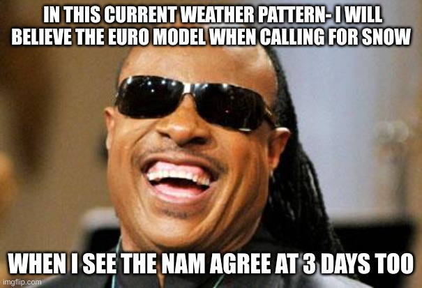
every GFS model run fakes this or that. This afternoons Euro run is trying to spit out something but it cannot get its act together. Lets face it, when the Euro and Nam both agree at 3-5 days, then we have something, otherwise every model run fits this meme in this shitty pattern. -
E PA/NJ/DE Winter 2022-2023 OBS Thread
Albedoman replied to Ralph Wiggum's topic in Philadelphia Region
this what I really think how the pattern will develop -
E PA/NJ/DE Winter 2022-2023 OBS Thread
Albedoman replied to Ralph Wiggum's topic in Philadelphia Region

-
E PA/NJ/DE Winter 2022-2023 OBS Thread
Albedoman replied to Ralph Wiggum's topic in Philadelphia Region
In all my years 15-20 yrs tracking models on the internet, I have never seen the GFSGEm and even the Euro so screwed up as it is right now in showing snow totals for our area at the end of the runs. Absolutely no confidence in anything over 5 days. The last 2-5 days model runs , the 12Z says 12+ and then the 18Z comes back and says zippo. Then the 0Z says 4" and the 6Z comes back with zilcho again. Yes I like snow but I also like rain. The primary rain events appear to be doing the same thing as well now. I guess I would say if nothing pans out between the 23rd and the end of the month for a major snow event, I will be writing off this winter. Yes I know Feb is our snowiest month but I cannot possibly see any consistent pattern developing on the LR in Feb with these models so wishy washy. I want to be optimistic but dam GFS/GEM and Euro throw me a bone and show me 6+ inches of snow in at least 48 hours worth of runs. Sorry for the rant guys but this is getting plain ridiculous to even look at the models over three days looking for LR patterns to develop when we cannot even get consistency from run to run.