Albedoman
-
Posts
1,321 -
Joined
-
Last visited
Content Type
Profiles
Blogs
Forums
American Weather
Media Demo
Store
Gallery
Everything posted by Albedoman
-
funny you said this. I lived less than .5 mile from the ongoing Hurst fire location back in the 1970's. My parents old house was in the voluntary evac last week in Newhall/Santa Clarita Valley. Many times when I was in high school, I had to water down the roof while helicopters were dumping water on our property and with red fire retardant. Had a huge firewall/break in my backyard. Believe me a can write a book about my life's weather experiences from the climate/weather patterns from Ca to the mid west to the east coast. From tornadoes and 1.5 inch ice storms in Memphis Tn, blizzards and extreme cold in Wisconsin -25 degrees , to dust/fire storms in California and Mojave Death Valley temps in the 120's, to hurricanes in Mississippi, earthquakes and finally all the weather here in eastern PA since the 80's I would get up in the morning in Newhall, shivering from low 40's and in the same afternoon I would then be swimming in my neighbor's pool at 85 to 95 degrees with 50 mph Santa Ana winds blowing and humidities down to 9%. I have experienced rain at the Newhall house and then driving up that afternoon to Gorman/Tejon Pass (less than 25 miles) and getting my car stuck in 4-6 ft snows (not drifts) with snow blowers(not Plows) clearing I-5. I actually have B/W photos of this experience I could post.
-
I agree, best computer back in the day. I used it for writing my papers in college and spreadsheets in the late 70's to 80's. You had to know DOS. Many of you probably do not even know that these computers were actually all made in Audubon PA- Lower Providence Township. Unfortunately, Commodore Computers went out of business at this location in the 1990's because they ended up polluting the ground water with TCE trying to clean up the computer chips at this facility. Pretty bad-- Superfund site. Spent a lot of time with EPA and Commodore while working in LPT trying to get the groundwater cleaned up. I have worked on environmental cleanups at many superfund sites before retiring--- Blue Mt Palmerton Zinc mine, Heleva Landfill, Dorney and Novak landfill, Rodale Printing, Moyer Landfill, Hebelka Battery,and Caloric facilities https://hackaday.com/2020/09/30/video-exploring-the-abandoned-birthplace-of-the-6502-and-commodore-64/ https://montco.today/2020/10/take-video-tour-of-abandoned-birthplace-of-6502-microprocessor-commodore-64-in-norristown/# https://www.commodore.ca/commodore-history/the-rise-of-mos-technology-the-6502/ https://en.wikipedia.org/wiki/MOS_Technology
-
Birds-69 and other posters . Many of you do not know my background and why I am so concerned about the drought. Frankly, I am an expert at soil science, stormwater, planning bioengineering and geology with 45 years experience and education. Here is my background: Michael Siegel is currently retired as an Urban Planner. Previously Michael served as the Director of Community Development for Lower Providence Township. Michael Siegel is a graduate from the University of Memphis with a B.S. degree in Physical Geography with an Environmental and Atmospheric Concentration and a Minor in Geology. Mr. Siegel has also received post-graduate work in Urban Resources Planning at the University of Memphis. He has authored several articles for national land use planning publications and has presented several papers at national and local seminars on topics such stormwater quality and soil bioengineering techniques for wetland construction stormwater basin conversions. Mr. Siegel has received training certifications for hydrology, water quality management, wetland determinations and conservation planning with the Natural Resource Conservation Service and Pennsylvania Department of Environmental Protection. Additionally, Michael has received extensive training for Environmental Law and Regulations from Rutgers University and for Wetland Delineation from Shippensburg University. Mr. Siegel has served as an adviser for several PA Act 167 stormwater management watershed boards for Lehigh County, PA and for the Groundwater and Wellhead Protection Program for Lehigh and Northampton County, PA. Michael previously held the certification of a certified Building Code Official under the Pennsylvania Uniform Construction Code. Michael has been certified as an expert witness for stormwater best management practices from the PA Environmental Hearing Board and was former President of the Little Lehigh Watershed Coalition which helped authored and initiated PADEP’s current stormwater water quality policy. Michael has also previously served on the Lower Macungie Township Zoning Hearing Board, Planning Commission and Environmental Advisory Council. Michael has previously held the position of the Environmental Coordinator and Conservation Resource Specialist with the Lehigh County Conservation District. He has also held several municipal positions such as the Zoning Officer for North Whitehall Township and the Zoning and Planning Administrator for Lower Nazareth Township and Lower Mt. Bethel Township. Furthermore, Michael has served as the Environmental Advisory Council Liaison for Lower Nazareth, Lower Macungie and Lower Mt. Bethel Townships. During this tenure he has authored several zoning ordinances on topics such as riparian buffer areas, lighting, floodplain management, landscaping requirements, architectural features, signage and various other subdivision and land development ordinances and municipal zoning ordinances during his tenure. Michael has co-authored comprehensive plans for Lower Providence Township. Michael was a past member of the Pennsylvania Association of Township Supervisors, a past member of the American and Pennsylvania Planning Associations and a member of the Pennsylvania Association of Environmental Professionals. Finally Michael has received several key awards for planning and smart growth techniques including twice being awarded Pennsylvania Governors Award for Excellence in Planning, the Montgomery County Award for Excellence in Planning, Whitehall Township Environmental Award and the Pennsylvania Horticultural Greening Award.
-
Yes we are pissing it away but what is worse we are not getting anything in return rain or snow. If we do not get 12+ snow storm by mid Feb or a few heavy rainfall events when the ground is not actually frozen, we are in some real deep shit. The ground water tables are really falling now, causing the water lines to break when the lines are not held up by the unstable soils. Moisture in the soils helps stabilizes them for the winter.
-
the youngsters in this forum have no concept of dominating and sustainable undesirable climatic patterns like in the late 60's to mid 70's. Winter did not exist for the NE. Yearly droughts were abundant. Because a few idiots that have no science background but have big mouths in the media forum shout at the top of their lungs that it is global warming, they are gullible and all simply wrong. Just wait until the SJS and NJS start colliding again in the deep south with a consistent deeper troughing pattern running up the coast for 10-15 days. Lets see the naysayers get buried in 2-3 feet of snow for weeks on end with below normal temps. . I remember all of the Miller A storm events that have virtually disappeared in the last 10-15 years that were in abundance in the 90's. They will come back. This last winter storm event for the Tn Valley this week was the first time in many years that we had an LP form in SE Texas only to become a southern slider. The trough over us was just too deep with confluence winds. Wait until it relaxes somewhat after MLK. If the LP's keep on forming in SE Texas, all this crap talk about climate warming will go away. Just imagine if this pattern was to stick around for the entire month of Feb?
-
Hey guys, two major sinkholes in the last two days one in Hanover Township near the LVI airport- took out a bunch of homes and the video below in philly. Its only going to get worse like I said late last week with this drought. The groundwater tables are falling like a rock with frozen topsoil layers https://www.itemfix.com/v?t=kn547p
-
I agree. When the SE ridge comes back, so will the storms running toward us. Why? The rex block in the SW pac off of California will finally begin to break down after next week too less wildfires in LA too. This will create more troughs in the US and less progressive weather patterns. Lets just hope the cold air sticks around too at the same time First and last call 2-4 inches for the LV if we are really lucky with the snow ratios. Just enough to get the ground white. Time to put this storm to rest for the LV. No drought buster for sure. From Philly west to Harrisburg 6-8 in is a good bet --Warning level for them- advisory for the LV. This storm is a Ohio Valley special. From Indianapolis to Columbus to Washington, they get buried. They deserve it as they have been snow starved for years too. Our turn will becoming around Martin Luther King Day. Cold and dry will become the norm like the December... January 3 I said this same thing yesterday. The confluence will hopefully weaken a little as the LP moves slightly northeast of the projected path possibly creating higher snow ratios for the LV. This storm will also be remembered for ushering into our area the very windy and dry cold weather for the entire week. Freeze up the lakes and river time. Ice jams later in Jan/Feb? Hope people have humidifiers in their houses and a lot of chapstick as baby the static electricity will be unreal. The heating bill will skyrocket after this week. Saturday at 02:27 PM
-
OH shit, have to bring out the leaf blower again for Saturday. I have literally blown more leaves the last week or so than pixie dust snow. The pixie dust has evaporated away already. Refresh with another .05 in of snow is going to bury me on Saturday morning. I might have to break out the broom.
-
too many posters have not experienced the late 60's weather patterns with the lack of a decent winter storm pattern, no internet and modelogy with six hour runs.. Nothing surprises me the last 3-5 years with the extremes with these storm events as well. All I can say is be patient. The title of the thread should have been "southern sliders or southern comfort - your choice|" Good food with a good drink can create an atmosphere which is needed in this confluence dominating pattern for the youngsters.
- 993 replies
-
- 2
-

-
- metsfan vs snowman
- bomb
- (and 2 more)
-
Hell I am even pissed. Its going to snow in Memphis for a 4+ inches warning event and we get jack shite here. These confluence driven winds are killing us literally. I have never seen 3-4 days of blustery winds in a row here in the forecast. To make matters worse, it is cold and dry. The snow on my driveway is literally melting in the sunshine and immediately evaporating away with the dry winds in front of my eyes. Do not even have to use a shovel or salt, just a broom. How bad is this scenario? The salt in the parking lots and driveways are still crystallized and have not turned into brine, thus dragging the salt into all of the buildings/ stores and houses. Have not seen this in many years. I am shocked business have not said much as cleaning companies for carpet and hardwood floors are going to have a banner spring. Thats how dam dry it is. This drought is really becoming an issue again folks. The band aid rains we had after Christmas have done little to nothing to recharge the existing ground water tables and only enabled us to maintain a low stream flow in the non-limestone streams. Now all of these non limestone streams, lakes and ponds are so low, they are freezing up bigtime. I am telling you all that unless we get a 12+ snow storm in our area, this spring is going to be really bad for irrigating and even fishing, not to mention wells drying up. The drought watches will be extended into the spring for sure. Worst of all, sinkholes are going to open again in February with the lowering of the groundwater tables.
-
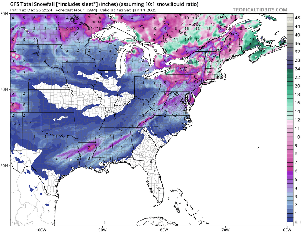
I posted this on Christmas Eve: MIller A potentials setting up by mid January. For the first time in 5+ years, I see GOM lows forming off the SE Texas coast in the LR modeling. The 4 corner lows are dipping down into Mexico , going west into the GOM and sucking up the moisture from the GOM, then heading NE. Hope this pattern keeps up. Rule of thumb for the newbies- If it snows in Memphis/Dallas, we usually get 6+ in of snow here. With the lows forming and deepening in Southern MS, we stand a good chance of seeing this scenario unfold. December 24, 2024 This pro thinks a lot like me. The Euro tends to hold back the LP in the Gulf of California way too long. I believe it does this as a clear bias too as I believe it is waiting for the ocean buoy data to catch up to land mass data too while running the model. This pro has been around to know Dr Sobel and others who I also followed while earning my physical geography/atmospheric concentration degree in the early 80's. Notice , he emphasizes the Dallas to Memphis setup in his video as well. This comes from knowing historical weather pattern setups for major eastern winter storms and just not relying on individual model runs.
-
all this 12Z GFS run tells me that a snow event will happen. that is likely more than 6 inches if everything lines up perfectly. Its a dam shame that even a basic dying La Nina pattern storm has to be considered a thread the needle storm event as these LP's are constantly going progressive coming across the country. A good kicker would really help this time.
-

1/6 snowstorm - nuisance event or something bigger?
Albedoman replied to LVblizzard's topic in Philadelphia Region
posters these days want a foot or more for this event which is not going to happen. Many are wishful kids that have little background in meteorology and love to critique weather models, no matter what the range the computer model was originally designed for. You and I just want to see frozen precip on the other hand and try to use whatever SR model fits the bill for the existing pattern and or storm event. Basically many posters have no weather history of actually experiencing the formation and outcome of a winter storm in certain patterns using modelogy patterns. Thats why many do not respond to me in a positive limelight. For example, If they even knew what a "travelers advisory" really meant and how storms evolved without the internet by simply trying to interpret weather models with only physics or a meteorological background 30 = years ago, many posters would be on this board right now at 3 am like you and me. Thats the true weather historic experience. and not simply regurgitating their opinion -wishcasting- on a LR only weather model within 24 hours of the storm event. This video clip below is what I experienced before the NWS changed the winter warning system. and makes me LOL. Travelers advisory- now called winter weather advisory -really meant no traveling should take place no matter how much ice or snow and was set at a top range 4" or less everywhere especially before a winter storm warning was issued. That is where the word" plowable " came from too as most municipalities set the depth of snow to 3" or more before plowing. We need to go back to the way it was. The winter warnings system are now too convoluted with too much specific criteria to the average intelligence of the non scientific community now who have never taken any geography or weather courses in school. Specifically winter storm criteria of six inches is set way too high as it is now nearly double the amount of plowable snow depth for local municipalities . A winter storm warning criteria should go back to 4" everywhere. In other words, the average Joe blow has no idea what the NWS criteria is for the issuance of a winter storm today and really does not care. But a plow driver/municipalities sure do and these guys were left out of the picture when these NWS warning decisions were made in the last 20 years. Thats why I track and rely on weather history to formulate my forecast for my family and friends. -
1/6 snowstorm - nuisance event or something bigger?
Albedoman replied to LVblizzard's topic in Philadelphia Region
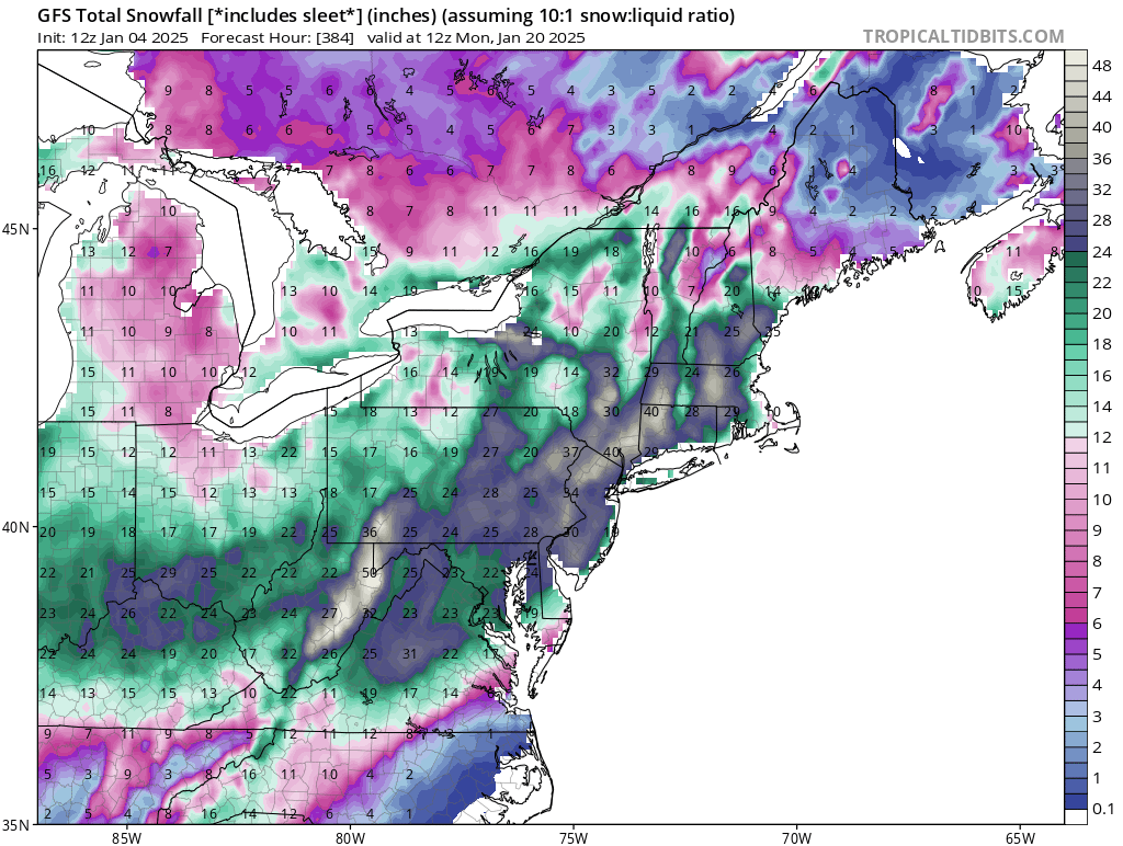
My final call remains from 2 days ago- 2-4" for the LV . Hoping for lollipops and higher ratios which would be nice. Norlun trough? My real hopes starts on the 11th - a real plow buster of snow events in the works for the next two weeks. The best thing happening in the models which absolutley nobody has dwelled on right now - at least 15- 30 days of continous snow cover is a good bet - a real winter in my book that I have not seen in a decade. -
1/6 snowstorm - nuisance event or something bigger?
Albedoman replied to LVblizzard's topic in Philadelphia Region

-
1/6 snowstorm - nuisance event or something bigger?
Albedoman replied to LVblizzard's topic in Philadelphia Region
I said this same thing yesterday. The confluence will hopefully weaken a little as the LP moves slighlty northeast of the projected path possibly creating higher snow ratios for the LV. This storm will also be rembembered for ushering into our area the very windy and dry cold weather for the entire week. Freeze up the lakes and river time. Ice jams later in Jan/Feb? Hope people have humidifiers in their houses and alot of chapstick as baby the static electricity will be unreal. The heating bill will skyrocket after this week. -
1/6 snowstorm - nuisance event or something bigger?
Albedoman replied to LVblizzard's topic in Philadelphia Region
Yes, 12 hours ago. Gfs forget it -
1/6 snowstorm - nuisance event or something bigger?
Albedoman replied to LVblizzard's topic in Philadelphia Region
First and last call 2-4 inches for the LV if we are really lucky with the snow ratios. Just enough to get the ground white. Time to put this storm to rest for the LV. No drought buster for sure. From Philly west to Harrisburg 6-8 in is a good bet --Warning level for them- advisory for the LV. This storm is a Ohio Valley special. From Indianapolis to Columbus to Washington, they get buried. They deserve it as they have been snow starved for years too. Our turn will becoming around Martin Luther King Day. Cold and dry will become the norm like the December 20th-25th time period. -
1/6 snowstorm - nuisance event or something bigger?
Albedoman replied to LVblizzard's topic in Philadelphia Region
I will repeat for the naysayers below. Analyze all you want. Tonights 's 0z runs will be exciting for most of you. Has been a few years waiting. The NAM will be the usual suspect. The northward trend at the end of the run is very promising for the philly area. Posted 12 hours ago I have repeatly posted the last 3-5 days, plz wait until the 0z runs tonight. Thats where the W PAC data gets really ingested into the models for the first time. Anyone analyzing every 4-6 hour model run will work themselves into an utter panic attack. This is from 30+ years of modelology experience. Tomorrow nights 0z runs should be quite exciting after this clipper swings by and leaves a trail of bread crumbs to follow for the next snow event. Thats where the true path should come to fruition for next weeks storm. -
I have repeatly posted the last 3-5 days, plz wait until the 0z runs tonight. Thats where the W PAC data gets really ingested into the models for the first time. Anyone analyzing every 4-6 hour model run will work themselves into an utter panic attack. This is from 30+ years of modelology experience. Tomorrow nights 0z runs should be quite exciting after this clipper swings by and leaves a trail of bread crumbs to follow for the next snow event. Thats where the true path should come to fruition for next weeks storm.
-
Firts of all, as I stated yesterday, tomorrow nights Oz run will tell us what we will get. The Pac buoy data will be ingested and will show us how much moisture streams NE. Right now it looks like zippo- just like the other crap we have had in December- cross your fingers that the ealier Euro runs hold 3-5 days ago. Noy good for ending the drought thats for sure Yes Red Sky is spot on- time if the sky clears out, Aurora time. You all should check this site veryday. Flares do affect us https://spaceweather.com/
-
nice t storms tonight. This was even better than a 2-4 inch snow event. Times a changing now.
-
I am sticking to 3-5 days out analysis when the W Pac buoy data gets ingested into the models. No sense even lookig at the LR models now until Jan 2. Now is the time when the Euro and GFS will lose the storms or they get squashed by supression or some other model performance stunt as this is beginnning of a really major upcoming pattern change The 0z run on Thursday morning might show what will really happen going into this new pattern. Anything on the models now is just where the pattern is leaning. The cold temps after this pattern gets set in is what concerns me. I see a huge CAD event aiming for us toward the 20th time frame in our area as these LP's are finally to form along the SE Texas coast as stated in an earlier post with the deep cold and a potential deep snow pack in place. I do not like ice storms like 94. Salt shortages may become an issue again by mid February if this cold pattern stays put This potential salt situation reminds me of the TP hoarding syndrome in 2020 with COVID. A lot of salt will be needed with the cold temps in place unlike previous years. Many municipalities will be ordering more salt which will become problematic as these same municiplaities will be ordering the salt at the same time. Be prepared for long lines at the car washes on sunnier warmer days and salt being gone at places like home depot. This situation with the deep cold/snow pack is exactly what I stated several months ago that would occur when I said the La Nina was weakening going into a neutral pattern. Many posters disagreed. I go by past weather history patterns and events , not just modelology. All it takes is a major pattern change and that is coming next week. The drought conditions are finally but slowly starting to relax now has ralso eally demonstrated this weakening LA Nina pattern too as this new pattern neutrality will eventually break the current drought by the end of Feburary.
-
The 3-5 trusted w pac buoy data has not even been ingested at 10 days. I will not take until five days from the event I have been burned plenty of times.
-
Hey guys, look at this evenings 18Z GFS run. Looks like Dallas to Memphis gets some snow in week or so and oh wait 6 in + for us too. Now where did I hear that scenario before? LOL I love the memphis discussion below for tonight. It is a dream forecast for me to hear booming t- storms at Christmas Hell , we could not even squeeze out one decent t- storm here all last summer with any booming thunder and they get it in the winter. What slap in the face for us. .DISCUSSION... (This evening through next Wednesday) Issued at 205 PM CST Thu Dec 26 2024 Shortwave ridging across the region has allowed mostly dry conditions across the area today. These dry conditions will be short lived as a low pressure system will return showers and thunderstorms later this evening. Depicted on deterministic soundings, a steep inversion will be over the Mid-South this evening. This inversion will keep the gusty winds from mixing to the surface as well as limit surface based instability. A maritime tropical airmass has struggled to move over the region with this inversion as dewpoint depressions are still around 10 degrees or more at this hour. The severe weather threat tonight is very marginal at best. The thunder, however, will be intensified due to the inversion, so prepare for loud thunder to awake you overnight. While the severe threat is limited, heavy rain is still a concern. Precipitable water (PW) values will be in the 90th percentile (around 1.3") for this time of year. Highest rainfall totals will be along and west of the Mississippi River hovering around 2".