OrdIowPitMsp
-
Posts
2,791 -
Joined
-
Last visited
Content Type
Profiles
Blogs
Forums
American Weather
Media Demo
Store
Gallery
Everything posted by OrdIowPitMsp
-
Pity that MSP isn’t the bullseye but this should still end up with substantial totals at the airport. Going to go out and do round 1 of shoveling and measure soon.
-
Hi-res models have swung the heavy death band south of the metro now. 50 miles will make the difference between 12-15” and 18-24”
-
Vis under a mile now. Wind is shredding the dendrites and already causing minor drifting
-
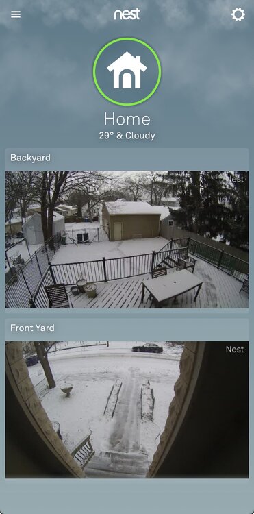
Ground is dusted, snow getting steadier. Here we go!
-
Nice explanation by MPX on pulling the trigger for a blizzard warning. So the Blizzard Warning... There is high confidence given the snow totals and strength of winds that blizzard conditions will be observed in our traditional "blizzard alley" from west central to south central MN, especially late Sunday morning into Sunday night. For eastern Minnesota into western WI, blizzard purists may argue that we don`t hit blizzard conditions of a 1/2 mile or less visibility with wind gusts of 35 mph or more for 3 or more consecutive hours. This is because the strongest winds will be lagging the heaviest snow and eastern MN and western WI really need the heavy falling snow to achieve the visibility requirements of a Blizzard Warning. However, we are looking at historic snowfall amounts for a March storm (see climate section), with travel expected to be crippled across our entire area tonight into Sunday night. In addition, when the common citizen looks out the window Sunday morning (ie. not the blizzard purist!), they`ll likely say, yup, this is one heck of a blizzard. Given the expected high to extreme impacts, we felt comfortable in pulling the biggest winter messaging lever we have, the Blizzard Warning. Simply put, travel is expected to be very dangerous on Sunday and the best way to get the message across on just how severe this winter storm will be is to go with Blizzard Warning.
-
Interesting I didn’t dive into that. I usually just look at the 10:1 maps. If we can get extended time in the deformation band, ratios should improve.
-
MPX mentioned low ratios, in setups like these it’s what typically happens. Also it’s mid March not January.
-
Just saw it. Wow, going to be hard to sleep tonight if that’s what’s in store. Optimism growing. Top 10 or bust!
-
I’d definitely feel better in your location versus mine. (Lake Nokomis - S. MPLS) Either way I’ve got cautious optimism in a metro wide 12-18” Starting to spit flakes here.
-
Nice! Welcome! I’m a little nervous about the dry slot or mixing making its way into the southern half of the metro, but you’ve gotta be close to maximize the pivot. I think Anoka or Forest Lake is the place to be, but this should be fun regardless.
-
Current thinking from MPX
-
I wish there were more MN posters. I can only post so much on the weekdays with job and parenting duties. NAM has me nervous but I’m chalking it up to NAM doing NAM things. 8-24” is a comfortable range at this juncture.
-
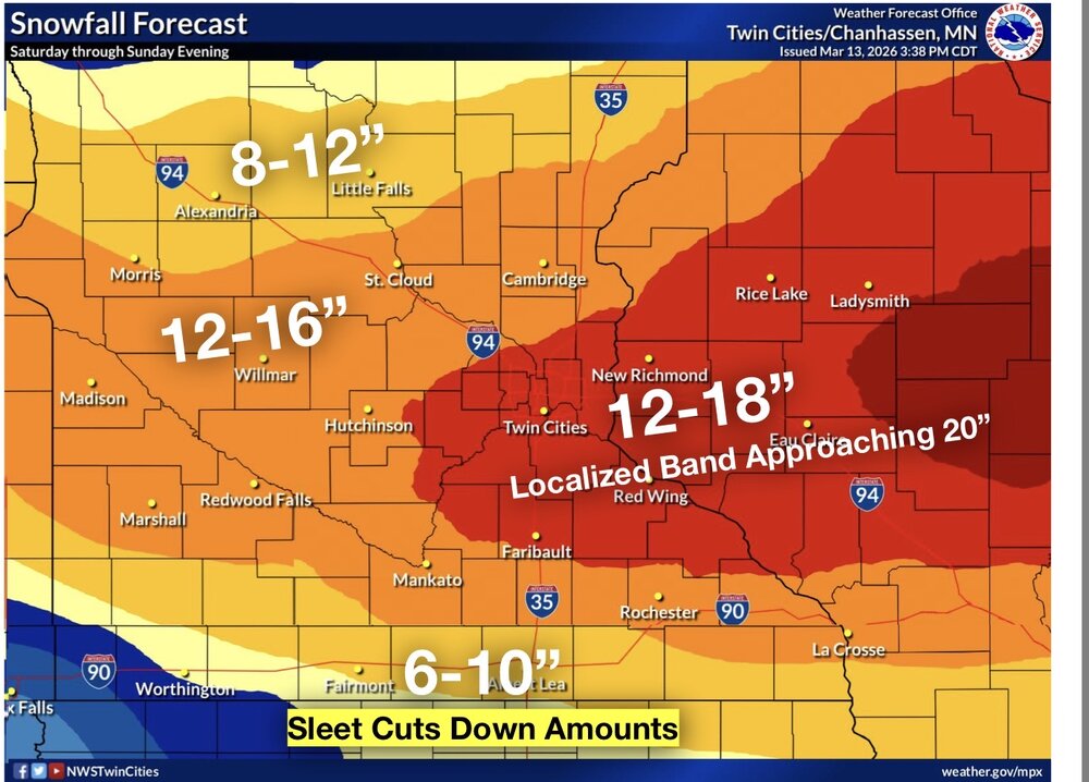
Upgraded to a Winter Storm Warning. Surprised they pulled the trigger this early. Figured it would happen with the afternoon update. The first concern is heavy snow, with a broad area of 10 to 16 inches likely, and a narrow swath of 15 to 20 inches Totals across portions of western and central Wisconsin could approach 2 feet. The heaviest snow will fall Saturday evening and overnight, with rates of 2 inches per hour possible. Winds will start out of the northeast at 20 to 30 mph.
-
0.1” snow yesterday. Max wind gust of 58mph at MSP
-
Getting some white rain. The calm before the wind.
-
Cut these totals by 50-60% at least. Fun for posterity, dangerous for social media. 29” at MSP

-
High wind warning followed by a winter storm watch here.
-
I’ll start putting trust in what models are showing 12z Saturday. First call (throwing a dart blindfolded) 7.3” at MSP
-
The dumb default iPhone weather app shows 16-19” of snow here Sunday and the normies are freaking out.
-
27.1” this season at DSM. I think it started hot but faded like most areas west of the lakes.
-
Wouldn’t mind a nudge north but I have a feeling this is an I-90 special. It’s been an entertaining week of model watching already, 12z euro is about as good as it gets
-
Eyeballing around an inch
-
Snow beginning here. The more persistent band is setting up to my north as modeled. Guessing we’ll see about an inch.