gallopinggertie
-
Posts
589 -
Joined
-
Last visited
Content Type
Profiles
Blogs
Forums
American Weather
Media Demo
Store
Gallery
Everything posted by gallopinggertie
-
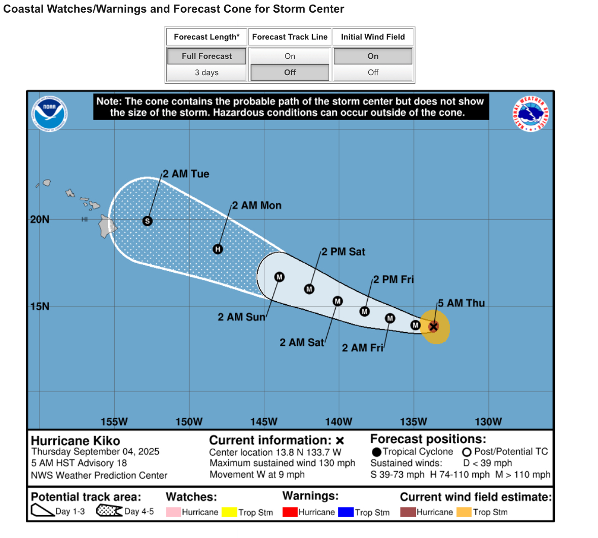
Central & Eastern Pacific Thread
gallopinggertie replied to Windspeed's topic in Tropical Headquarters
-
Central & Eastern Pacific Thread
gallopinggertie replied to Windspeed's topic in Tropical Headquarters
I saw that. It also sounds like there’s at least an outside chance of a TS landfall on the east side of the big island. -
Mountain West Discussion
gallopinggertie replied to mayjawintastawm's topic in Central/Western States
Hopefully tropical storm Lorena brings some rain to the desert southwest, most of that area is still in at least severe drought (D2). -
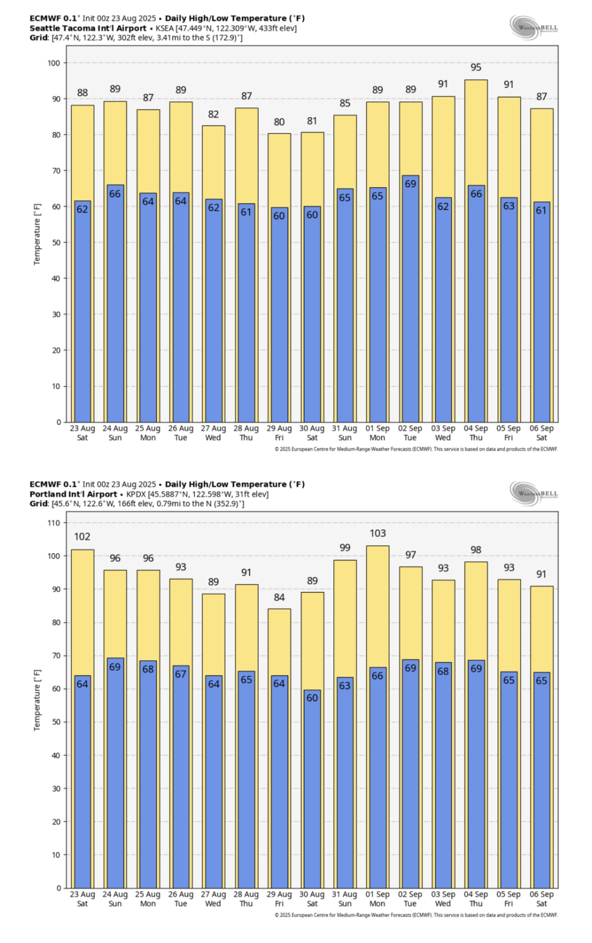
Occasional Thoughts on Climate Change
gallopinggertie replied to donsutherland1's topic in Climate Change
It’s looking like this might only be the beginning of this particular hot period - here’s the new ECMWF forecast for Seattle and Portland, showing a two-week stretch that would average 10-15 degrees above normal for the region. Pretty wild. I’ve lived in western Washington and Oregon my whole life, and the summer climate has really changed over just the past couple decades. Like you posted about, heat waves used to last maybe two or three days - now they stretch on for a week, or longer. Here in Portland our climate averages have historically fallen in the Csb (warm-summer Mediterranean) range, but are on track to push into Csa territory (hot-summer Mediterranean) before too long, perhaps when the new 2000-2030-year averages become the new baseline. Seattle probably will follow a few decades later.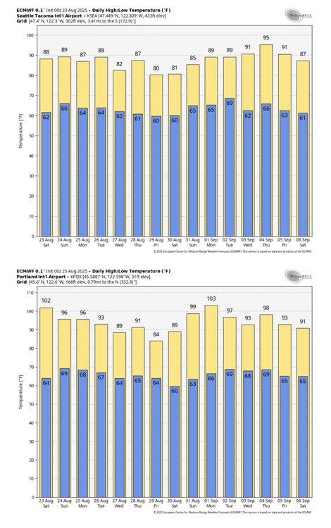
-
Arctic Sea Ice Extent, Area, and Volume
gallopinggertie replied to ORH_wxman's topic in Climate Change
The current rate of global warming is pretty much unprecedented in the geological record. Wouldn’t the current amount of undersea volcanic activity then also have to be unprecedented to be the main driver of the warming? But it isn’t, is it? The Earth has gone through periods of volcanic activity way more intense than anything that’s currently taking place. The rate of CO2 increase on the other hand is also pretty unprecedented…just like the speed of this warming. Hmm. Really makes ya think, doesn’t it? -
Occasional Thoughts on Climate Change
gallopinggertie replied to donsutherland1's topic in Climate Change
PDX just reached 100, for the first time this year and setting a daily record. If the next few days reach forecast highs, the majority of August record highs at PDX will have been set in the past ten years! -
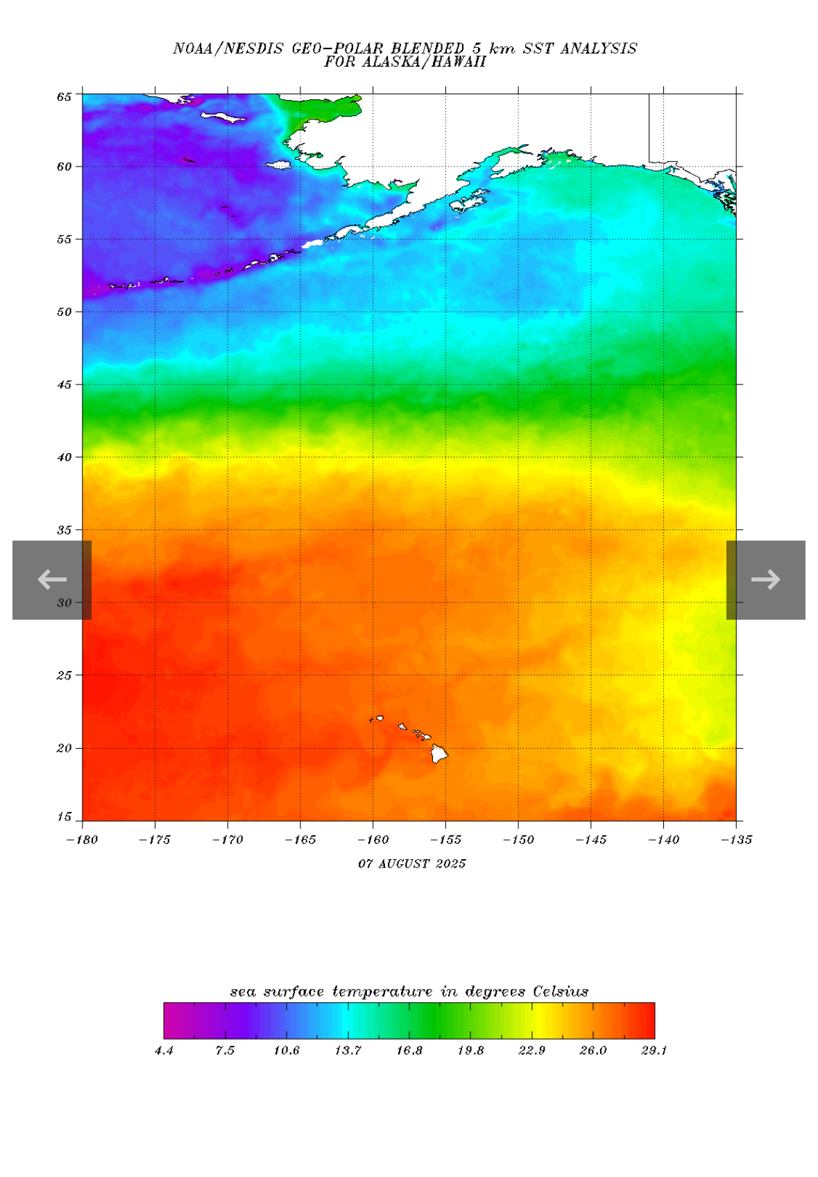
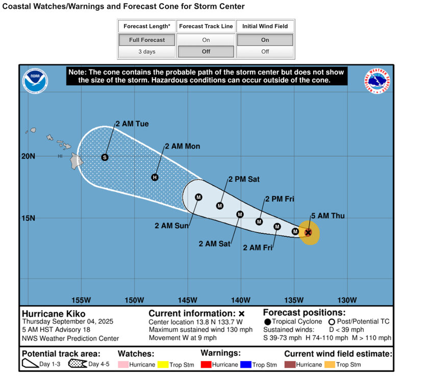
Central & Eastern Pacific Thread
gallopinggertie replied to Windspeed's topic in Tropical Headquarters
SST’s are way above average in the North Pacific. Actually, they’re warmer at the end point of that forecast cone than they are where Henriette is right now!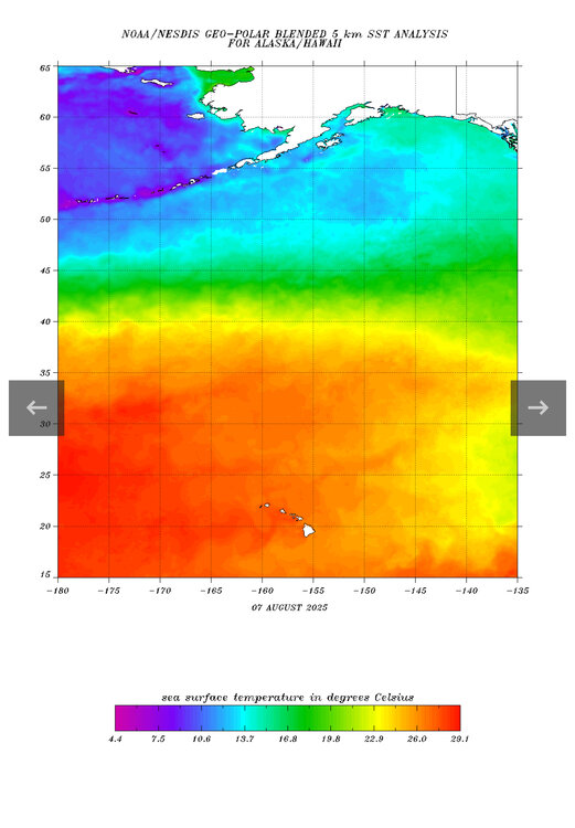
-
Anyone calling the rapid climate change we’re seeing “minor warming” like you did, is probably a bit daft. Sorry…but there comes a point when if you can’t see reality for what it is, maybe you should spend your time doing something other than constantly posting in this thread.
-
Central & Eastern Pacific Thread
gallopinggertie replied to Windspeed's topic in Tropical Headquarters
Apparently, Erick beat the record for earliest-landfalling major hurricane in Mexico. And specifically, it beat the record for earliest-landfalling major on Mexico’s pacific coast by over two months! The next earliest was…August 26. -
Mountain West Discussion
gallopinggertie replied to mayjawintastawm's topic in Central/Western States
NWS Fairbanks has just issued its first ever heat advisories. The temperatures are not that unusual for interior Alaska (in the mid to upper 80’s), but the duration of the heatwave will be at least a week. They’re trying to prepare people better for heat up there than they have in the past, which is smart seeing as houses in alaska lack ac and they can expect more and more of these heat events in the coming decades. -
Mountain West Discussion
gallopinggertie replied to mayjawintastawm's topic in Central/Western States
Had a nice cold core thunderstorm yesterday in Portland. It poured rain and small hail with some gusty winds and a loud clap of thunder. The NWS put out a special weather statement for it, which was like a consolation prize for the severe thunderstorm watch last week that turned out to be a nothing burger. -
Mountain West Discussion
gallopinggertie replied to mayjawintastawm's topic in Central/Western States
This turned out to mostly be a bust. Cape values were way lower than forecast, and the mid-levels were too dry. I didn’t even hear thunder in Portland. Western WA had a decent amount of lightning, but actual severe weather impacts were limited to a couple storms in the Olympic peninsula and Cascades around Snoqualmie Pass. A big letdown for me, since this is the first time I’ve been in a severe thunderstorm watch.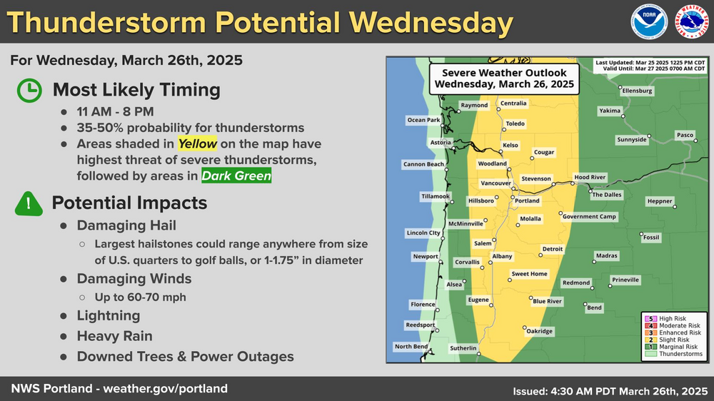
-
Occasional Thoughts on Climate Change
gallopinggertie replied to donsutherland1's topic in Climate Change
That’s for sure. Not only global warming, but ocean acidification and microplastic pollution will become huge problems. As a random aside, Portland OR (where I live) broke its all-time march record high yesterday, with a high of 82. -
Mountain West Discussion
gallopinggertie replied to mayjawintastawm's topic in Central/Western States
A highly unusual severe weather threat is forecast today for the Pacific Northwest. Seattle and Portland are both in SPC’s slight risk zone. I wouldn’t be surprised to see a severe thunderstorm watch hoisted for both cities (that would be the first ever for Seattle proper, I believe).
-
Mountain West Discussion
gallopinggertie replied to mayjawintastawm's topic in Central/Western States
That storm last weekend was pretty good (by Portland standards), we ended up with about 4” here. That makes it an incredible 9 straight winters I have seen at least 1” of snow, quite the run for the Pacific Northwest. -
Mountain West Discussion
gallopinggertie replied to mayjawintastawm's topic in Central/Western States
Round two of this mini storm tonight in Portland. After this morning’s dry snow, the evening brought light freezing rain, and now moderate sleet mixed with snow. Roads are ice rinks! -
Mountain West Discussion
gallopinggertie replied to mayjawintastawm's topic in Central/Western States
We finally are getting our first (and probably only) snowstorm of the winter here in Portland, Oregon. It’s a dry snow and we already have a bit over 1” since it started snowing an hour and a half ago. This is the first time I’ve seen proper snow since moving here last winter! Snowfall averages only about 4” per winter here. So anything we get is special, but particularly so when we get one of these cold dry snows that immediately start sticking to the road! -
Tropical cyclone Elvis is south of Madagascar, all lonely and heading for the Heartbreak Hotel.
-
Mid to long range discussion- 2025
gallopinggertie replied to wncsnow's topic in Southeastern States
Back in the 90s, I was witness to a famous southern snow… -
Snow, on Bourbon Street (NOLA)
gallopinggertie replied to Stx_Thunder's topic in Central/Western States
So is this an all-time record for NOLA? -
Sounds like snow pellets or graupel, aka sleet that was coated with rime crystals. Congrats on the frozen precip! You’ve now outdone both Seattle and Portland for the winter. (Very sad achievement for the Pacific Northwest, one of only two or three truly snowless winters I have experienced here).
-
Looks like Jacksonville will be on the edge of the wintry precip. I would issue a WSW if I were the NWS just to be safe, after all Gainesville is under one…
-
And seems pretty certain Houston will also get historic snowfall, at least the eastern half of the city.
-
NWS has issued winter storm watches for the Big Bend and even Gainesville!
-
Panama City goes from nothing to 4-5”…