gallopinggertie
-
Posts
593 -
Joined
-
Last visited
Content Type
Profiles
Blogs
Forums
American Weather
Media Demo
Store
Gallery
Everything posted by gallopinggertie
-
Occasional Thoughts on Climate Change
gallopinggertie replied to donsutherland1's topic in Climate Change
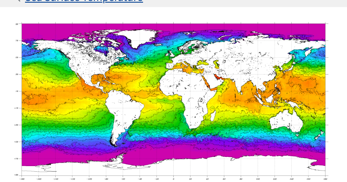
Current SST anomalies and contour chart. The western Mediterranean Sea is 5C above normal, with temperatures over 30C south of Sicily! Even the Black Sea is pushing into the range of temps warm enough to support tropical cyclones.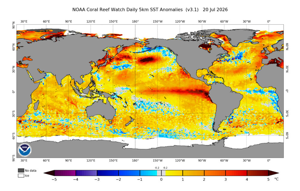

-
Mountain West Discussion
gallopinggertie replied to mayjawintastawm's topic in Central/Western States
Bozeman also seems to have set a new all-time high today of at least 106 (previous record was 105). -
Mountain West Discussion
gallopinggertie replied to mayjawintastawm's topic in Central/Western States
Wow, Miles City got up to at least 115 today and Billings 111. Both all-time highs by a margin of 3-4 degrees. -
Mountain West Discussion
gallopinggertie replied to mayjawintastawm's topic in Central/Western States
Some stations in eastern Montana could break their all-time highs today. Miles City is already up to 100 at 11 am. -
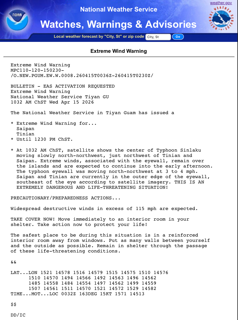
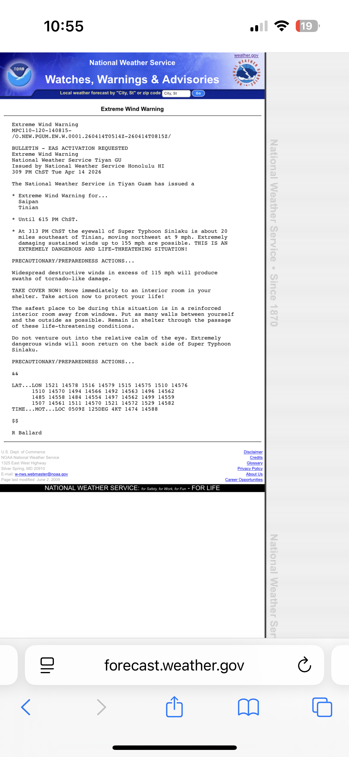
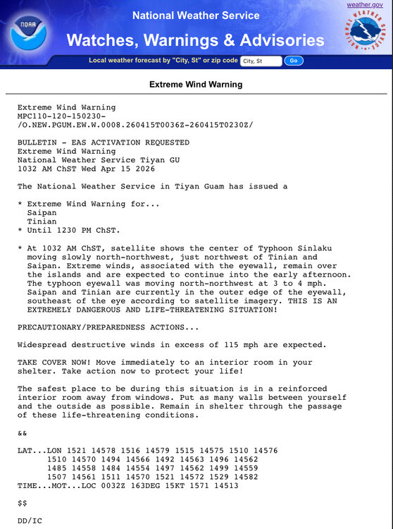
JTWC is forecasting tropical storm Bavi to pass directly over Saipan and Tinian in a few days as a 160 mph typhoon. I really hope the track changes. Typhoon Sinlaku just caused over $1.5 billion in damage to Saipan and other islands in April.
-
Mountain West Discussion
gallopinggertie replied to mayjawintastawm's topic in Central/Western States
Yesterday’s thunderstorm chances were a bust in most of the Willamette Valley. This was really been the most boring past year of weather I can remember. No snow or ice, no windstorms, hardly any lightning… -
Occasional Thoughts on Climate Change
gallopinggertie replied to donsutherland1's topic in Climate Change
I was in London on Saturday, and it was hot and humid (also it seemed like the entire city was outside enjoying the sunshine). One of the metro lines was stifling hot even with air con. Crazy that it got up to 95 there! The southern UK is predicted by many climate simulations to have a hot-summer Mediterranean climate by 2100. -
Mountain West Discussion
gallopinggertie replied to mayjawintastawm's topic in Central/Western States
Today was the earliest ever 91-degree high at PDX (Portland, OR). This beats the previous record by three days. Pretty odd to have a heat advisory on May 3rd. -
Mountain West Discussion
gallopinggertie replied to mayjawintastawm's topic in Central/Western States
Seattle had a good thunderstorm a few days ago with hail and even a waterspout! But nothing in Portland besides a tiny bit of hail. The weather here has been preternaturally boring over pretty much the entire past year. -
Wikipedia has the following up on Sinlaku’s article, based on sources like the Red Cross. It sounds bad. ” Sinlaku caused catastrophic destruction across the Northern Mariana Islands, particularly on Saipan and Tinian. With sustained winds reaching 150 mph (240 km/h), the storm demolished numerous wooden and tin-roofed homes and caused significant roof failures in commercial buildings.[36] The entire electrical grid on both islands collapsed, and toppled communication towers left residents without mobile or internet services for an extended period.[37] The storm's slow movement across the archipelago resulted in intense rainfall—exceeding 20 inches (51 cm) in some areas—and severe flash flooding.[38] In residential districts, winds were powerful enough to flip vehicles and stack them on top of one another, while many concrete homes suffered from water seepage through every crevice. Critical facilities, including Northern Marianas College, faced fresh setbacks as buildings still being repaired from previous storms were battered again.[39]”
-
The extreme wind warning had to keep getting renewed over Saipan and Tinian as the giant eyewall slowly made its way across the islands. So while Sinlaku was weaker than Yutu, it was still plenty strong (cat 4 equivalent) and a very long-duration wind event.
-
Sinlaku is now forecast to pass directly over Saipan and Tinian. Really hope it misses, as those islands have already had bad hits from typhoons (like Yutu) in recent years.
-
2026 Atlantic Hurricane Season
gallopinggertie replied to Stormchaserchuck1's topic in Tropical Headquarters
It’s weird that Sally wasn’t retired, having caused over $7 billion in damages. -
Mountain West Discussion
gallopinggertie replied to mayjawintastawm's topic in Central/Western States
Hilo, Hawaii is under an Ashfall Warning! https://forecast.weather.gov/wwamap/wwatxtget.php?cwa=HFO&wwa=ashfall warning -
Occasional Thoughts on Climate Change
gallopinggertie replied to donsutherland1's topic in Climate Change
Those past catastrophic events in the geological record didn’t have anywhere near as rapid a rise in CO2 as we are causing now, yet still caused mass extinctions. It’s easy to forget how truly short our lives are - the fact that baby boomers have seen a rise of about 30%, give or take, in CO2 levels over the course of their lifetimes, is crazy. -
Occasional Thoughts on Climate Change
gallopinggertie replied to donsutherland1's topic in Climate Change
There’s also the rapid rate of change, which is way too fast for most species to keep up with. As one example, marine heatwaves may be driving sea star wasting disease that has caused huge mortality of starfish on the US pacific coast. Then of course there’s coral reef bleaching, where warm SST’s are causing the wholesale destruction of entire reef ecosystems…those are just a couple of examples. It seems like coral and starfish aren’t able to respond quickly enough to the changes to avoid their populations taking serious damage from them. Maybe if this were all taking place twenty times more slowly, it would be different, and coral could adapt or migrate to new areas more easily. The media tends to way underreport on the non-human impacts of climate change, since people are disinterested in things that they don’t think will affect them personally. Also it seems like ecology is one of the least well-understood sciences, which is probably why we keep being blindsided by problems like colony collapse disorder in honeybees. All this to say, it’s not just about whether a warmer earth is “better” or not, it’s a question of how fast that rate of change is and whether human society and the natural world can respond in time. -
Mountain West Discussion
gallopinggertie replied to mayjawintastawm's topic in Central/Western States
It has been absurdly snowy this month in Juneau, Alaska (upwards of 6 feet of snow in March), in fact they have now set a new record for snowiest winter! https://www.ktoo.org/2026/03/23/juneau-breaks-march-snowfall-record-but-not-the-winter-record-yet/ -
Yeah, the UHI is real but it seems clear this event has been incredibly anomalous even outside of the big cities. One example is that Nogales has seen 11 record highs in a row. Nogales is a fairly small town whose population today (just under 20,000) is barely higher than it was in 1980. Looking at satellite views, you can tell there is not much paved area there (even the cross-border Nogales is quite compact) and it’s surrounded by undeveloped mountains, so it seems like a good foil to Phoenix.
-
Today Flagstaff had a high temp four degrees higher than their April record high…
-
Mountain West Discussion
gallopinggertie replied to mayjawintastawm's topic in Central/Western States
Looks like Flagstaff had a high of 84 today, which is 4 degrees above the April record high. -
Mountain West Discussion
gallopinggertie replied to mayjawintastawm's topic in Central/Western States
Alaska is the only winner this winter in the western US. Juneau has had at least 50” of snow in March, and looks to have had something like 200” for the winter to date, over twice of their normal. Despite that, they’ve had just 67 days with 3” or more of snow depth, reflecting their maritime climate. -
https://news.un.org/en/story/2026/02/1166956 Definitely a bad situation in Toamasina, this sounds like Acapulco after Otis.
-
From Wikipedia: “In Toamasina, where Gezani made landfall, buildings and walls collapsed, power poles and trees were downed, and roofs were blown off buildings.[41] At least 20 deaths, 15 missing and 33 injuries were recorded, with over 3,200 homes damaged or destroyed and 2,742 people displaced.[42] Malagasy president Michael Randrianirina said 75% of Toamasina had been destroyed by the storm.” :(
-
February 2026 OBS & Discussion
gallopinggertie replied to Stormlover74's topic in New York City Metro
Is there any chance sea ice forms in Long Island Sound with this upcoming Arctic cold?