

gallopinggertie
-
Posts
589 -
Joined
-
Last visited
Content Type
Profiles
Blogs
Forums
American Weather
Media Demo
Store
Gallery
Everything posted by gallopinggertie
-
I’d suggest having more nuance, Milton wasn’t the worst case scenario but plenty of communities in florida aren’t “just fine” right now either.
-
The roof is made of fiberglass coated with Teflon, so I’m not sure if it’s accurate to call it fabric. Also, I’d be concerned about water damage to components of the structure as rain falls on it.
-
Milton is about to cross over Florida’s tallest mountain range, the mighty Lake Wales Ridge.
-
Wow, is this the first extreme wind warning ever issued for a major city?
-
Yeah, it looks to be 3 or 4 hours from making landfall judging by its current speed and heading.
-
The difference that occurs to me is Milton is a good bit smaller than Katrina. Though NHC has mentioned several times they expect it to grow in size before making landfall. They’ve also mentioned Milton might already be beginning to make extratropical transition by the time it makes landfall, which is pretty wild.
-
I had the same thought, was also surprised by people saying that IKE would be really high for that reason.
-
Pardon my ignorance, but how common is a rainfall event like this in western Florida? I thought they were used to torrential rains from summer thunderstorms, but that does sound exceptional.
-
2024 Atlantic Hurricane Season
gallopinggertie replied to Stormchaserchuck1's topic in Tropical Headquarters
Seasonal ACE in the Atlantic is now higher than in the W Pacific! -
Wouldn’t it be closer to Ian ($113 billion)? The Sarasota metro area has about the same population as the Ft. Myers area. Or are you thinking higher because Tampa will still get bad flooding even with the forecast track to the south of the bay?
-
NHC new track is ever so slightly shifted south, with a landfall between Sarasota and St. Petersburg.
-
What kind of surge would Tampa get with a landfall just to the south of the bay?
-
Is this the smallest cat 5 since Felix in 2007?
-
Yeah, wth? Apparently the hospital was built in the 1920’s - can’t believe they never decided to relocate it.
-
It really depends on the species. Some birds (like petrels or albatrosses) can fly for weeks at a time over the ocean without stopping! Other species without that level of endurance might not be able to make it.
-
I suppose that’s true. I posted a comment there urging people there to take this seriously—hopefully someone reads it and decides to evacuate. If not, well, there’s nothing I can do.
-
And the more it weakens, the more complacent people will be, which isn’t good.
-
Looking at the r/Tampa subreddit, I’m concerned. Seems lots of people aren’t taking this seriously, brushing it off because “oh it’ll just weaken to a cat 3.”
-
Just to the south of the bay (like by 15 miles). Would that be enough for Tampa to escape the surge?
-
You said “Florida will handle this with ease” though…it’s wild to make that statement confidently at this point.
-
And landfall right over the Tampa Bay area. At face value, that would be their worst hurricane since 1921.
-
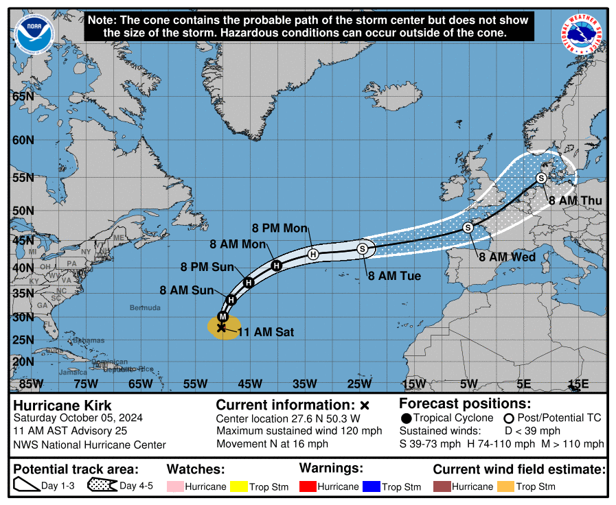
Now skirts the coast from France to Denmark:
-
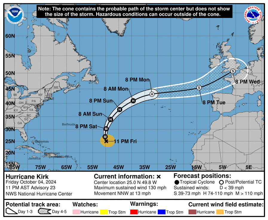
Though Kirk will be long extratropical by the time it reaches Europe, it’s cool how the last forecast point is just southwest of London, UK.
-
Nice opening line, lol.
-
I think that’s correct. And unfortunately there is a dearth of weather stations in that area—it looks like there’s no stations at all on the immediate coast between St. Mark’s and Cedar Key.


