KoalaBeer
-
Posts
628 -
Joined
-
Last visited
Content Type
Profiles
Blogs
Forums
American Weather
Media Demo
Store
Gallery
Everything posted by KoalaBeer
-
Gusted to 69mph at KMLU as it passed through. https://mesowest.utah.edu/cgi-bin/droman/meso_base_dyn.cgi?stn=KMLU&unit=0&timetype=GMT
-
Ready to bomb out, you guys are going to keep getting crushed as this thing gets going in the GOM. Jealous.
-
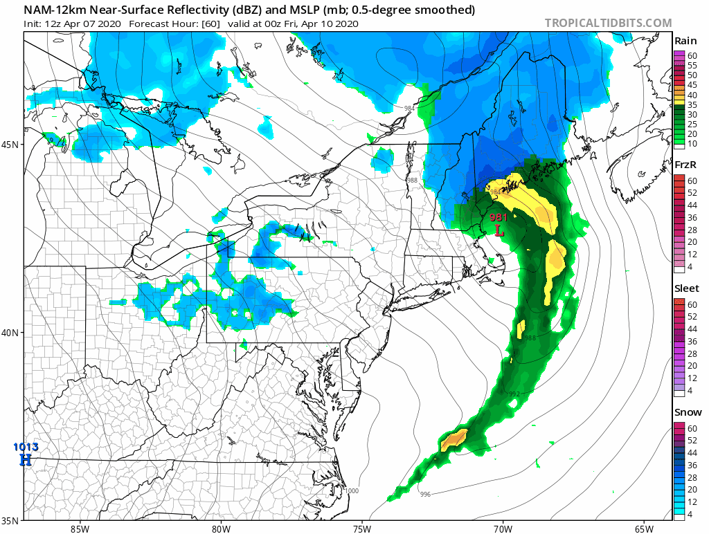
Thinking about taking a ride up to the lake house in Ossipee after work and staying the night but it's not looking great for that area, just a little to far south and not much elevation...plus the whole don't travel if necessary thing would make me feel guilty about going up there. Hopefully we can score some decent storms later and I''ll be keeping an eye on the coastal flooding at home, definitely been a nuisance for some folks the past few tide cycles. This weekend is looking increasingly nasty in the south. Dare I say we could see a high risk day on Sunday issued by the SPC? 12z NAM soundings are pretty crazy across southern areas of MS and AL.
-
I knew you would be on top of posting this once I saw them expand it. Looks like an active severe wx week for much of the country. If the Euro is right the southeast really has to keep an eye out on this weekends threat.
-
 12z NAM gets the coastal going a little sooner again. Could be a coastal beat down with the astro high tides.
-
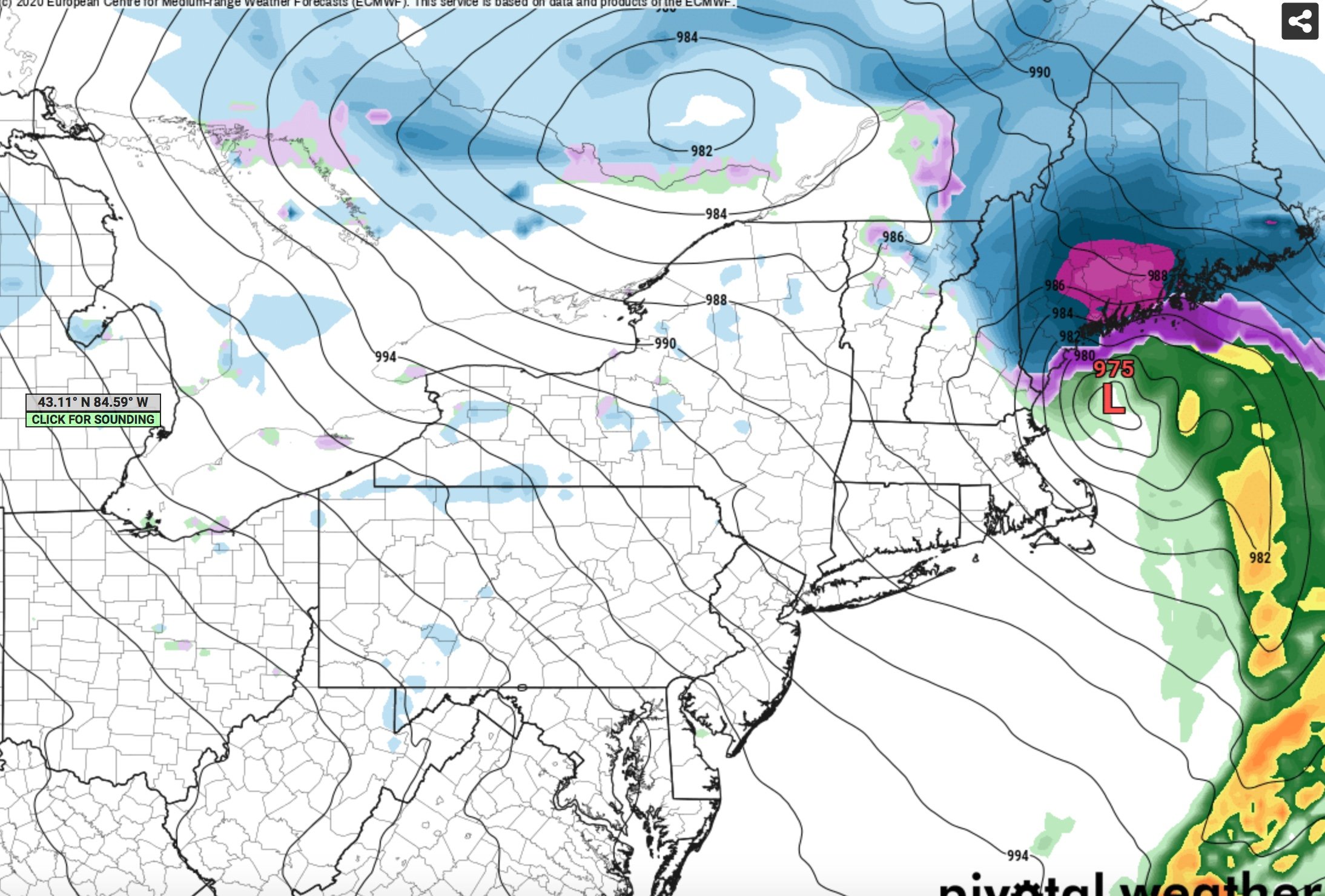
Tonights Euro...NNE could still get pounded this week.

-
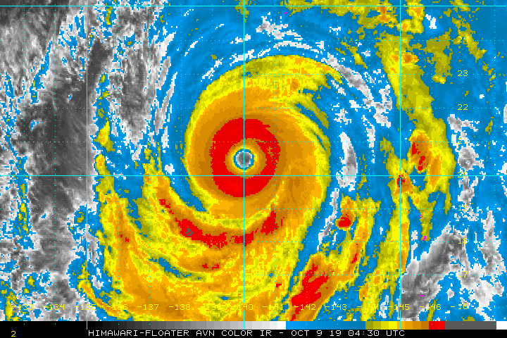
Cat 5 landfall imminent? Waiting to see if it clears out that eye completely.
-
I'm getting sick of the cold wind blasted rain along the shore the past few weeks, Sunday and Monday felt like 24+ hours of 30mph sustained winds with cold rain... I definitely would of taken the snow with this one if I had a choice. Not like I'm doing anything outside anyways, beaches, golf courses, ski resorts all closed. Even Mount Washington is closing off access to tuckermans, gulf of slides etc to back country travelers. Coastal flooding would be much more of a concern though if this came in next week during astronomical high tide.
-
What a beast on satellite. It's really starting to back NW now watching the loops. Should be fun to watch the surf tomorrow morning. Quite a few ECMWF members make it sub-tropical as well.
-
March 26-28 Severe Threat
KoalaBeer replied to Tim from Springfield (IL)'s topic in Lakes/Ohio Valley
NWS now saying the Oregon/Rockford TOR is confirmed on the ground by radar. Starting to show up on CC on a few frames. Looks to stay SE of downtown Rockford in my opinion if it holds together. -
March 26-28 Severe Threat
KoalaBeer replied to Tim from Springfield (IL)'s topic in Lakes/Ohio Valley
Ya lot of damage videos coming in now. -
March 26-28 Severe Threat
KoalaBeer replied to Tim from Springfield (IL)'s topic in Lakes/Ohio Valley
Yikes -
March 26-28 Severe Threat
KoalaBeer replied to Tim from Springfield (IL)'s topic in Lakes/Ohio Valley
Holy crap massive tornado and debris on the live stream -
March 26-28 Severe Threat
KoalaBeer replied to Tim from Springfield (IL)'s topic in Lakes/Ohio Valley
Pretty likely it’s on the ground, hopefully it can miss downtown just to the southeast edit: hopefully I’m wrong if that webcam footage is accurate -
If you took it with an iPhone click on it in albums, hit edit on the top right, and then and the bottom left there will be a little button that lets you rotate it. 70 degrees out here! Swapped out the snowboard in the car with the golf clubs. Hoping I can get out early enough from work for a quick 9.
-
Winter 2020 New England Banter and General Obs
KoalaBeer replied to CapturedNature's topic in New England
Ya we shall see, I think the damage in Cookeville might end up being EF-4 (photos below.) Not that it really matters. The toll is staggering regardless what it gets rated. -
Winter 2020 New England Banter and General Obs
KoalaBeer replied to CapturedNature's topic in New England
And up to 21...just terrible. Looks life EF-4 to me based on the images I’ve seen but we will see what the survey says. Close to a worst case scenario with it being in the middle of the night and through a very populated area. I read at least 14 of the fatalities were in Putnam county over by Cookeville which is well east of Nashville. They should of had plenty of lead time to take precautions but perhaps it didn’t matter with the strength and timing... -
Winter 2020 New England Banter and General Obs
KoalaBeer replied to CapturedNature's topic in New England
What a beast in the North Atlantic. Analyzed at 925mb. Another record setting NYC—>LON flight incoming? -
Winter 2020 New England Banter and General Obs
KoalaBeer replied to CapturedNature's topic in New England
What an abrupt shift in temps that was on the coast in Hampton. Dropped 10 degrees in one hour from 69 to 59. I just made the move up here and though I'm sure I'll miss out on some snow from my last location in Methuen, overall the weenie in me will enjoy the weather here more being right on the water. Bring on the Nor'easters the next few weeks. I want to see what real high wind warning criteria actually looks like for once. -
Winter 2020 New England Banter and General Obs
KoalaBeer replied to CapturedNature's topic in New England
Holy crap that's awesome. Snow wasn't as intense here but the wind absolutely ripped as the squall passed through Hampton, NH. It was quite the impressive 20-30 minutes. -
Winter 2020 New England Banter and General Obs
KoalaBeer replied to CapturedNature's topic in New England
I was just thinking yesterday how moderate the temps have been this winter compared to the past few. There doesn’t seem to be many anomalous swings either way (cold or warm) when I feel like we had some big cold shots and then huge warm ups in recent years. It’s still early though. -
Winter 2020 New England Banter and General Obs
KoalaBeer replied to CapturedNature's topic in New England
Are these MDs the SPC have been doing on individual super cells relatively new? I feel like I’ve only seen them in the past year or two. SUMMARY...Based on recent radar and environmental data, a strong to potentially intense tornado with potential peak winds of 110 to 155 mph (EF1-EF3) is likely ongoing and tracking towards Alexandria, LA. DISCUSSION...Recent radar signatures from KPOE as of 1832z reveal a long track tornadic supercell characterized by a 0.5 degree rotational velocity between 61 and 70 kt. A tornadic debris signature has also been noted on recent radar scans. These signatures are occurring in an environment characterized by STP between 4 and 5. Previous signatures within similar environments produced tornado-damage-estimated wind speeds from 110 to 155 mph and confidence is high for likely strong to potentially intense tornado. A tornado is ongoing and may continue based on the rotational velocity continuity and the storm moving within a favorable downstream environment. -
Winter 2020 New England Banter and General Obs
KoalaBeer replied to CapturedNature's topic in New England
LWM 18f at midnight while BED is 8f. I have a hard time buying that. https://forecast.weather.gov/obslocal.php?warnzone=MAZ005&local_place=Wilmington MA&zoneid=EST&offset=18000 -
I was up by Tenney today on the way home from the Whites and it reminded me I need to check it out this year as well! If I recall correctly there is no snowmaking since they re-opened? All natural which is pretty sweet.