CheeselandSkies
-
Posts
3,332 -
Joined
-
Last visited
Content Type
Profiles
Blogs
Forums
American Weather
Media Demo
Store
Gallery
Everything posted by CheeselandSkies
-
The way I think of it for example, is... Hurricane Ike was so bad because it had tremendous IKE.
-
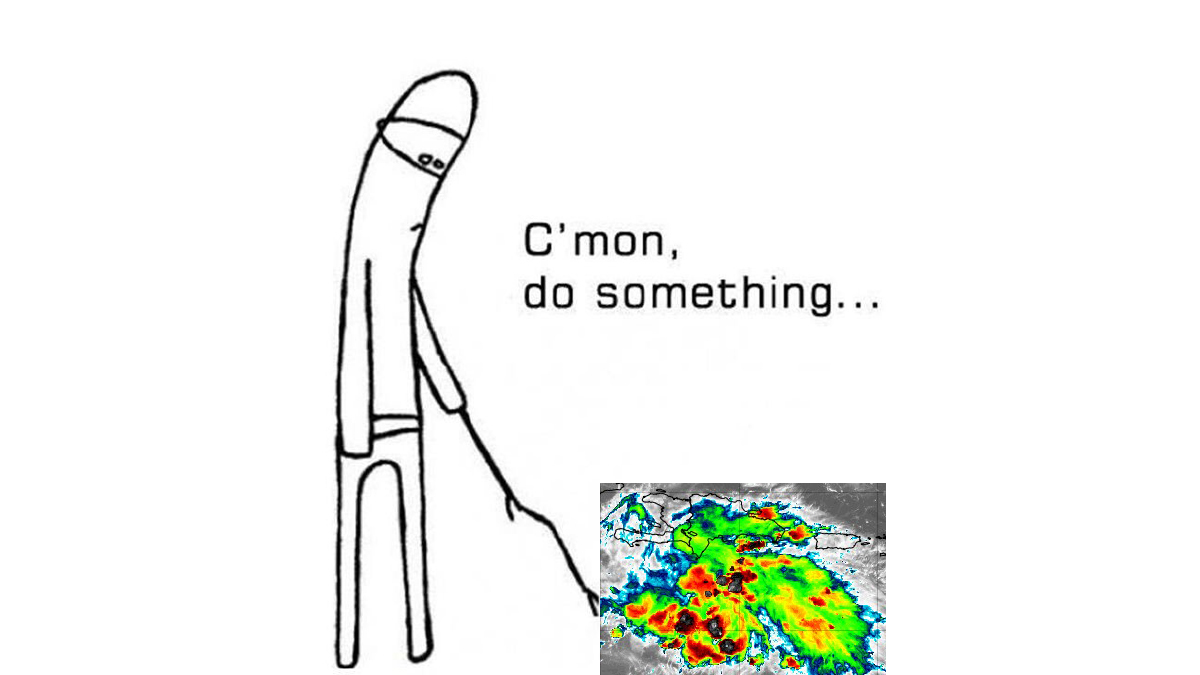
Man. The frame by frame analysis on here and other forums. It's strengthening! No, it's weakening! Getting whiplash reading through it. Personally I think (purely conjecture) it's probably about steady-state right now, still sorting out its structure post-ERC and dealing with some slightly sub-optimal atmospheric and oceanic conditions. We'll see what happens later today if it gets in a sweet spot of upper-level ventilation while passing over the Loop Current.
-
In 2017 I think Irma was going to but crashed into Cuba. In 2019, IIRC Lorenzo's first peak looked better on satellite at the dreaded 135kt but it was the second that was actually assessed as Cat. 5.
-
Globals (apart from the GFS for some reason) have difficulty resolving TC core intensity and their pressures should never be taken verbatim. Worst offenders IMO are UKMET, ICON and Euro, in that order.
-
Might be one of the most ominous forecast graphics I've ever seen from the NHC; perhaps short of last years' for Otis that effectively were "OH BTW A CAT 5 IS GONNA MAKE LANDFALL IN ACAPULCO IN LIKE 6 HOURS OOPS SRY."
-
Compared to one with a stable core, tropical cyclones undergoing EWRCs are more vulnerable to disruption by unfavorable environmental conditions; even transient ones, such as dry air entrainment from even modest amounts of shear. This is what usually causes substantial weakening post-EWRC, not the EWRC itself. If the conditions remain favorable and the cyclone has enough time before land; it can/likely will resume intensification as the new eyewall takes over and contracts.
-
12Z hurricane model suite is bombs away yet again. HWRF initializes with the current NHC pressure and has a borderline major hurricane within 12-18 hours. Both HAFS peak well into sub-920/Cat 5 territory, with HAFS-B once again flirting with the 900mb mark.
-
I used to chat on AIM with Alex in the mid-2000s when we were college-aged Wisconsin weather nerds. He knows what he's talking about.
-
Gotta bring this one up again:

-
HAFS duo has put the HWRF to shame as the "nuclear hurricane" model(s) of choice.
-
Apparently all my "Hurricane Milton" Office Space memes were tempting fate.
-
This isn't coming west/north over the Keys and/or Cuba and recurving a la Charley, Irma, Ian. Much different setup.
-
You said the "hurricane models" which I took to mean the frame-by-frame sim IR, MSLP, etc products from the HWRF, HAFS A/B, etc. Usually takes a couple hours after the run initialization time for those to even start showing up.
-
Eh? Those aren't even out yet on Tidbits.
-

2024 Atlantic Hurricane Season
CheeselandSkies replied to Stormchaserchuck1's topic in Tropical Headquarters
Stop copy/pasting what other people post on Storm2K. -
Are you "DunedinDave" on Storm2K or are you just copy/pasting others' posts from there? Sent from my Pixel 8 using Tapatalk
-
2024 Short/Medium Range Severe Weather Discussion
CheeselandSkies replied to Chicago Storm's topic in Lakes/Ohio Valley
A few pop-up severe storms in the region today, still hearing booms from the one that just rolled through southwest Madison. Almost looks like a legit supercell here in far SE MN approaching the MS River, although that outflow suggests production is unlikely.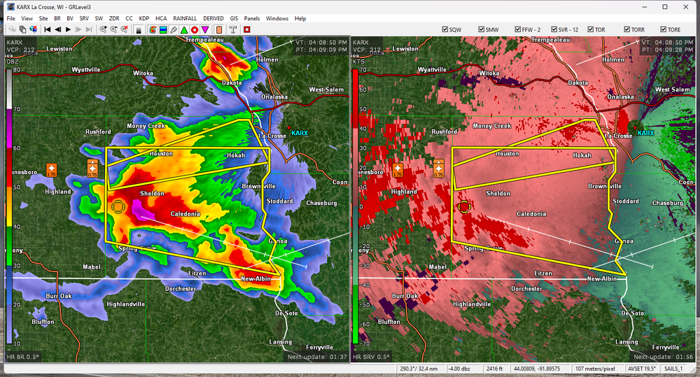
-
Being in a severe thunderstorm warning polygon was not on my bingo card for today.
-
2024 Atlantic Hurricane Season
CheeselandSkies replied to Stormchaserchuck1's topic in Tropical Headquarters

-
2024 Atlantic Hurricane Season
CheeselandSkies replied to Stormchaserchuck1's topic in Tropical Headquarters
Correct me if I'm wrong, but I think the 2013 comparison is apt because the alarm bells for this year were hit quite a bit harder than in 2013. 2013 was expected to be active, yes, but not "1933 in the satellite era" levels of insanity from ALL the seasonal forecasting sources of note. So the activity for 2024 has been somewhat greater, yes, but the bar was also set higher. Again, I could be wrong, since in the July-September period of 2013 I was moving and starting a new job, therefore I probably paid the least amount of attention to tropical weather of my life since I was old enough to watch John Hope on The Weather Channel. It was probably about midway through September when I was like "Huh, shouldn't there be some hurricane threats right about now? Guess it's a quiet season." -
2024 Atlantic Hurricane Season
CheeselandSkies replied to Stormchaserchuck1's topic in Tropical Headquarters

-
2024 Short/Medium Range Severe Weather Discussion
CheeselandSkies replied to Chicago Storm's topic in Lakes/Ohio Valley
My go-to CAMs (HRRR and 3K NAM, 12Z runs) both completely whiffed on the severe line which fired up in eastern WI late this morning and is now (in a considerably weakened state, even though there is a severe thunderstorm watch in effect out ahead of it) pushing into lower MI. Therefore, their depiction of activity (or lack thereof) for the rest of this afternoon/evening is rather suspect. -
2024 Short/Medium Range Severe Weather Discussion
CheeselandSkies replied to Chicago Storm's topic in Lakes/Ohio Valley
-
2024 Short/Medium Range Severe Weather Discussion
CheeselandSkies replied to Chicago Storm's topic in Lakes/Ohio Valley
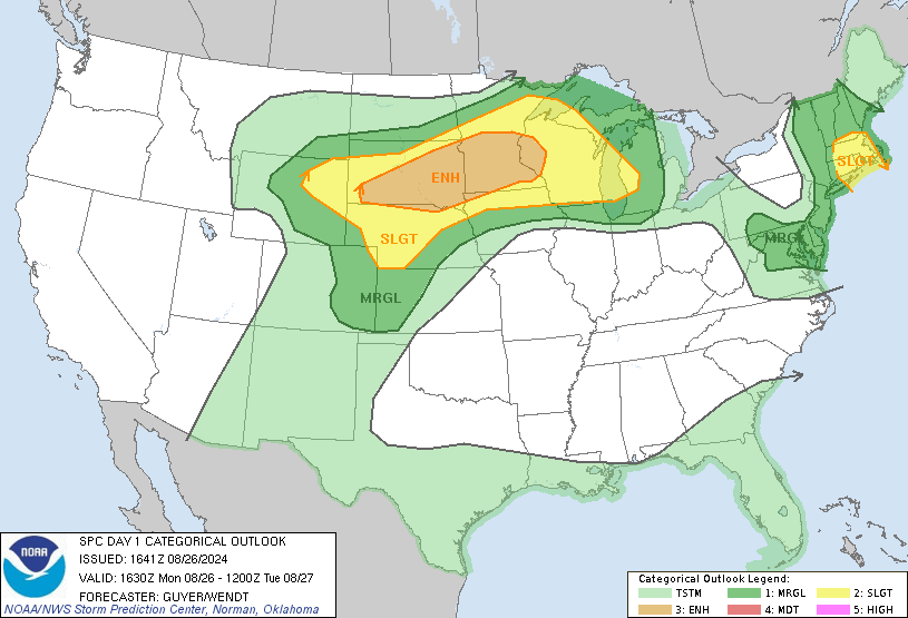
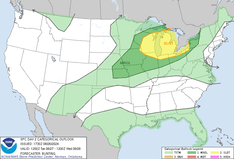
Next chance for the NW sub starts Monday evening, possibly continuing as far east as Michigan on Tuesday. -
2024 Atlantic Hurricane Season
CheeselandSkies replied to Stormchaserchuck1's topic in Tropical Headquarters
Atlantic tropics watchers in August 2024: Believe I posted this for August, 2022 as well.