George BM
-
Posts
3,008 -
Joined
-
Last visited
Content Type
Profiles
Blogs
Forums
American Weather
Media Demo
Store
Gallery
Everything posted by George BM
-
IAD beating out all the other airports with heat last year. So it only makes sense that DCA would beat out all the other airports with snow this winter.
-
I don't know how road conditions are up there or how much the temperature rose up there but it's currently 41F at IAD. However my neighborhood sideroads (Herndon, VA. ~2 miles from the airport) are still slushy and slick. Main roads appear to be marginally better. However, I don't know exactly how roads are between here and Frederick.
-
I got sight of the moon overhead. What a weird tropical cyclone.
-
IAD gusted to 50 kts (58mph)

-
Umm... IAD just gusted up to 56mph out of the ENE!
-
Mid-Atlantic forum winter 2021/22 snow totals thread
George BM replied to North Balti Zen's topic in Mid Atlantic
Herndon, VA 11/30/2021: T 1/03/2022: 6.0" 1/07/2022: 4.8" 1/16-17/2022: 2.8" ... Total as of January 17, 2022: 13.6" Highest La Nina snow total IMBY since 2006. -
Just a little more than 1 1/2 hours after it was 23F IAD has officially hit the freezing mark. IAD: 32/29 as of 7:36pm. Strong WAA doing its thing.
-
Wonder how much accretion we get on the trees before we pull far enough above that freezing mark for accretion to stop? Probably enough to make the trees look pretty.
-
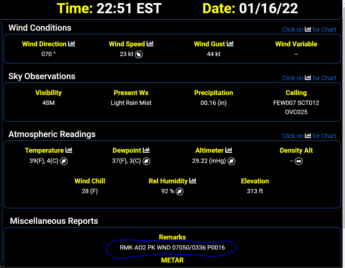
2.8" for the total here in Herndon before the flip. IAD was at 23F at 6:00pm. ... Now IAD has rocketed up to 30F as of 7:04pm est.
-
Nope. That's always been there. It's from some big hills to the SW of the site IIRC.
-
On February 7th, 2020 the surface pressure got down to around or just below 980mb. This is the event that spawned those QLCS tornadoes that morning.
-
Small flakes which shatter into white specks when hitting the roof of my car here since 12:50pmish. Herndon, VA
-
24/1 at IAD.
-
Putting this in here as well. Possible implications down the road? We'll see. This is the Tonga eruption which occurred just after 400z today.
-
Don't worry. DCA also got that midnight high of 34F today and will get that above freezing high at 11:59pm tomorrow in most classy DCA fashion. 30+ highs FO-EVA!
-
I patiently await your posting of it.
-
@Bob Chill
-
I know that everyone is focused on the MLK storm but it's actually a fairly mild day today. IAD up to 50F so far.
-
I thought we were past this stage. There's got to be a program that those two can attend to help with their problems. Bottling up anger to the point of kicking bunnies and puppies is so unhealthy for the heart.
-
Yeah. That Sunday return looks iffy atm with snow, potential heavy, during the PM hours of Sunday before any potential flip. At least that's how it looks at the moment. Details are still changing of course. I would AWD just to be safe.
-
Correct. ETA: Doobla ninja'd.
-
Nah. More likely DCA gets down to 22F during the night then rises towards morning as low-level southerly flow increases.
-
Come on DCA! Don't DCA this up!