George BM
-
Posts
3,010 -
Joined
-
Last visited
Content Type
Profiles
Blogs
Forums
American Weather
Media Demo
Store
Gallery
Everything posted by George BM
-
2022 Mid-Atlantic Severe Wx Thread (General Discussion Etc)
George BM replied to Kmlwx's topic in Mid Atlantic
Yeah. I've been keeping one eye on early next week myself. We're also getting into better CAPE season. -
2022 Max Temps: DCA: 88F IAD: 89F BWI: 87F RIC: 90F
-
There appears to be a little bit of smoke and/or dust aloft now as the sun is looking a bit more colorful (orangy reddish) than usual.
-
It honestly amazes me how @wxdude64 has kept at it consistently since October 1979. True dedication.
-
This is just a hypothesis of mine and I have no evidence whatsoever to back this up but... this recent trend of a colder pattern for the northern US and Canada come springtime. There are studies showing that the stratosphere is becoming colder (and stronger?) on average during the winter as the troposphere warms. Ex: This past February saw the coldest 50mb temps on record in the stratosphere over the high latitudes. I wonder whether the colder SPV during the winter allows it to survive longer (on average) towards spring without a significant disruption until the sun angle increases forcing it to weaken anyway. When it finally does weaken it may affect the troposphere and lead to more high-latitude blocking depending on how dramatic the disruption and/or SPV split is. Of course, the SPV and TPV are not always connected as seen earlier this winter and many other times in the past. Also, one could argue that there isn't enough data yet to know for sure how climate change is affecting the SPV/TPV. Like I said... just a hypothesis of mine. I have no concrete evidence to back it up.
-
Mid-Atlantic forum winter 2021/22 snow totals thread
George BM replied to North Balti Zen's topic in Mid Atlantic
Herndon, VA 11/30/2021: T 1/03/2022: 6.0" 1/07/2022: 4.8" 1/16-17/2022: 2.8" 1/20/2022: T 1/28/2022: 0.8" 2/13/2022: 1.4" 3/12/2022: 2.5" 3/26/2022: T 3/27/2022: T 3/28/2022: T 3/30/2022: T 4/09/2022: T 4/18/2022: T 4/19/2022: T ... Total as of April 19, 2022: 18.3" -
I saw a few mangled wet snowflakes and ice pellets mixed in w/ the rain att in Herndon.
-
Mid-Atlantic forum winter 2021/22 snow totals thread
George BM replied to North Balti Zen's topic in Mid Atlantic
Bump. -
The sleet has gotten a bit heavier. 42/30 at IAD.
-
Sleet here in Herndon as well. The April traces continue!
-
I wonder if some of us see some hail/gusty winds later with any convection/storms that manage to develop in the region. MLLRs will be fairly steep w/ 500mb temps of -20 to -22C. LLLRs look to be very steep as well. Weak instability (MLCAPE generally less than 500J/kg) owing to fairly low dews (45-50F) while a limiting factor may be slightly offset by the very steep LLLRs. Not expecting anything too crazy. Maybe some gusty winds and some hail like I mentioned.
-
CAPE is very pleased about this.
-
This is a nice site for one-min obs at IAD. http://iadasos.org/IAD/index.html
-
Now IAD is at 85/58.
-
IAD has hit 83F so far today.
-
@SnowenOutThere Yeap. I know what you're about to post.

-
Oh wow. Both of you chasing. That's a nice duo between you and your wife.
-
Mid-Atlantic forum winter 2021/22 snow totals thread
George BM replied to North Balti Zen's topic in Mid Atlantic
Herndon, VA 11/30/2021: T 1/03/2022: 6.0" 1/07/2022: 4.8" 1/16-17/2022: 2.8" 1/20/2022: T 1/28/2022: 0.8" 2/13/2022: 1.4" 3/12/2022: 2.5" 3/26/2022: T 3/27/2022: T 3/28/2022: T 3/30/2022: T 4/09/2022: T ... Total as of April 10, 2022: 18.3" -
Or some severe and upper 70s?...
-
Got my April trace! Just had a light shower w/ big raindrops mixed in with graupel at 52F.
-
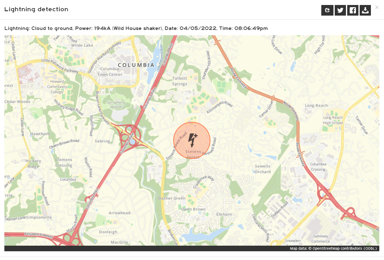
The bolt was a powerful 194kA positive CG. Lots of jumps, yelps and/or more personal "events" were probably had by peeps in the strike region... especially with no previous bolt to signify lightning in the area.

-
2022 Mid-Atlantic Severe Wx Thread (General Discussion Etc)
George BM replied to Kmlwx's topic in Mid Atlantic
-
Let the April traces commence!
-
Moving deeper into spring. Happy Pollen Sufferers Awareness Month!
-
New month starting. Baseball. NHL Playoffs w/ the Capitals? Booze consumption. Legit severe?