George BM
-
Posts
2,990 -
Joined
-
Last visited
Content Type
Profiles
Blogs
Forums
American Weather
Media Demo
Store
Gallery
Everything posted by George BM
-
2023 Mid-Atlantic Severe Wx Thread (General Discussion)
George BM replied to Kmlwx's topic in Mid Atlantic
A MRGL wouldn't surprise me if wind fields are strong enough and the pencil thin-line can tap into that wind aloft. -
New SON ONI/RONI out. SON ONI(rounded to nearest tenth): 1.8C SON RONI: 1.34C
-
Not for smoke enthusiasts.
-
...You're a very good storyteller.
-
BWI: 56.4" DCA: 40.2" IAD: 61.8" RIC: 32.7" Tiebreaker SBY: 37.2"
-
Happy beginning of a Meteorological El Nino winter! May it deliver us the fun white stuff.
-
IAD got down to 19F this morning.
-
Just over 2.25" here. Herndon. IAD: "Currently the temperature is 55 degrees under partly cloudy skies." Dewpoint 48. Winds NNW at 12mph.
-
I smelt smoke this morning while running. Now breezy and 55/40 at IAD.
-
Eh. I'd at least wait until Cinco de Mayo. We were not too far from an event in early May of 2020 when a wave tracked just off to our north followed by some flakes and graupel pellets flying in northern zones on the 9th of that month.
-
Unsolicited fact: Last December in the area was generally slightly BN temp-wise and AN precip-wise. (Yes. Luck was about as bad as possible in multiple ways that month. Our luck will be better this year.)
- 1,295 replies
-
- 2
-

-
- wishcasting
- almost winter
- (and 1 more)
-
Yeah. I wouldn't be too surprised if it got slick out there especially in colder spots N and W by morning. Lots of low-level moisture, clear skies, light to calm winds...
-
Dulles has just hit 79F breaking the daily record of 78F. ETA: Now 80F. lol ETA2: 81F.
-
What IPAs are you and everyone else in here celebrating this great day with?
-
Update ASO ONI (nearest tenth): 1.5C ASO RONI: 1.05C
-
Time sensitive. Smoke from the central VA wildfire is making the sun very red now. ETA: Particularly if you're in VA.
-
What was the relative humidity?
-
Just got back inside from a jog and there was heavy frost in clearings between trees that looked like a coating of snow.
-
Predawn run 4 days ago was a warmer than ideal 68F w/ moderate humidity. This mornings run featured temps into the 20s... just a wee bit of a difference. IAD snagged 25F.
-
First freeze for many likely by Thursday morning.
-
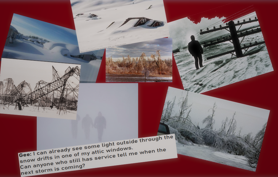
Forecast Discussion Monday, December 11, 2023 4:26AM EST A high to extreme impact overrunning winter event will affect the region over the next couple of days. Early this morning temps have fallen into the upper teens in the suburbs w/ low/mid 20s in town on NE winds. Snow has already moved into far southwestern areas including Charlottsville, Culpeper and Fredericksburg. This snow will overspread the rest of the area as dawn occurs. Temps could initially fall a few degrees, to 15-20F, as this occurs with the dry airmass in place. Snow will become heavy at times by mid-morning as the shortwave approaches from the west strengthening the WAA. Around that time, a changeover to sleet will occur over those southwestern areas towards central VA as warmer air aloft begins to overspread the region. This changeover to sleet will probably occur within the DC metro by midday or so as the aforementioned southwestern areas changeover to freezing rain. By the mid/late afternoon hours everyone south of I-70 in northern MD and the Baltimore metro region should have changed over to freezing rain. The precipitation throughout the day will be heavy at times. Temperature-wise most of the region will start the day in the mid/upper teens before rising into the lower 20s towards northern MD by late afternoon, mid/upper 20s in the Greater Washington metro region and perhaps to near freezing in our southern zones towards Fredericksburg and Culpeper. Despite the fairly heavy freezing rain rates through the afternoon the temperatures greater than 5F below freezing may allow for significant ice accretion on trees and powerlines leading to numerous to potentially widespread power outages by evening. Freezing rain will lighten up and become showery as we get into the mid to late evening hours but with temperatures remaining in the 20s ice accretion (especially given the lighter rates) will be efficient. By midnight, when round one should be out of the region, snow/sleet totals will range from 6-10”+ north of DC and across northern MD to 5-8” in the Greater DC metro region to 2-5” towards central VA and southern MD zones. Concerning ice accretion, areas near I-70 will most likely see around 0.25-0.4” of ice accretion with the Greater DC metro experiencing ½ to ¾ of an inch of accretion and southern areas receiving around half an inch as slightly warmer temps in those areas as well as the heaviest precip shifting north through the afternoon will limit ice accretion somewhat. As the first shortwave moves to our east during the overnight/ pre-dawn Tuesday hours colder air aloft will start moving back southwards over the region. As a larger slug of moisture moves into the region towards dawn with the main system approaching from the WSW precip in the form of snow and sleet will overspread the region with freezing rain most likely in southern zones. At the same time, a reinforcing shot of arctic cold air will push in from the very strong ~1060mb surface high to our north. As a result, as the air aloft warms during the day on Tuesday with heavy precip overspreading the region the surface temps will remain deep in the 20s and may even fall a few degrees F as we go into the midday/afternoon hours. Precip will take the form of heavy snow towards I-70 and Baltimore with heavy sleet across the Greater DMV. A significant to potentially catastrophic ice storm from freezing rain will be taking place mainly south of I-66 & US-50 at least through the midday hours. By Tuesday afternoon strong WAA aloft will allow all areas with the exception of far northern MD towards the MD/PA line (where a wintry mix will continue) to change over to freezing rain. Once again, the precip rates will be heavy at times w/ even some elevated convection possible during the afternoon and into the evening. While the air aloft will warm through Tuesday surface temperatures, thanks to the strong arctic high to the north, will likely remain steady ranging from the upper teens to the north to the mid/upper 20s in the southern reaches of the forecast area with the 20-25F range in between. It’s the PM hours of Tuesday that could prove to be truly historic with the chance of 1 to 2 inches of ice accretion on top of upwards of a foot or more of hardened snow and sleet. This may lead to catastrophic tree damage with structural damage to numerous buildings as well as nearly universal power outages. By Tuesday night the main area of low pressure will pass by just south of the region. As that happens freezing rain and a wintry mix will change back over to snow from northwest to southeast before all precip eventually tapers off by just before dawn on Wednesday. Once all of this is over snow and sleet totals of 10 to 15 inches will be commonplace in the region with upwards of 18+ inches in some locations in northern MD and 5 to 10 inches to the south. But on top of and embedded within that snow/sleet will likely be 1.5 to 2.5 inches of ice accretion potentially making roadways impassable for several days if not weeks given that temperatures will remain well below normal over at least the next 7-10 days with some sub-zero lows possible. Forecaster Wannabe: George BM
- 357 replies
-
- 13
-
-

-
I can see the dark shelf-like clouds approaching with it in Herndon.
-
IAD casually up to 86F breaking the daily record by 3F.
-
IAD got down to 34F. I saw patchy frost on the roofs this morning.