George BM
-
Posts
3,053 -
Joined
-
Last visited
Content Type
Profiles
Blogs
Forums
American Weather
Media Demo
Store
Gallery
Everything posted by George BM
-
2026 Mid-Atlantic Severe Storm General Discussion
George BM replied to Kmlwx's topic in Mid Atlantic
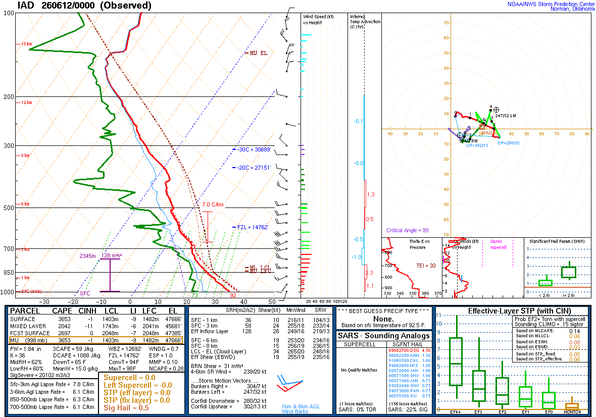
Sounding is in. Experts?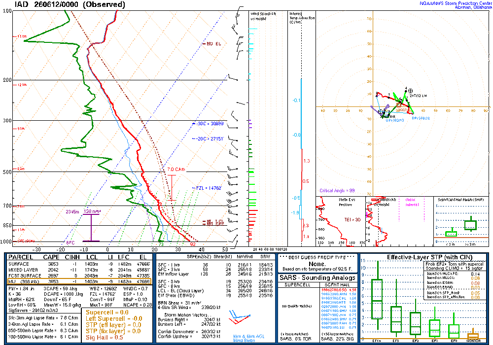
- 1,454 replies
-
- 1
-

-
- severe
- thunderstorms
- (and 7 more)
-
2026 Mid-Atlantic Severe Storm General Discussion
George BM replied to Kmlwx's topic in Mid Atlantic
Yeah these storms reminded me of a lower CAPE day but with steep LLLRs still allowing for big wind. Kind of similar to June 26, 2024 with a line of impressive wind producing storms with limited lightning. Hopefully LWX was able to launch the 00z sounding before the storms rolled through. The sounding would probably show some clues as we did have large CAPE and decent MLLRs (6.5+C) during the day.- 1,454 replies
-
- 1
-
-
- severe
- thunderstorms
- (and 7 more)
-
91/72 at IAD currently.
-
11/30/2025: T (A mix of rain/sleet from the 4am hour through about 9am. Intensity got up to light/moderate intensity at times. Temps: low/mid 30s 12/02/2025: T (Probably had a brief period of sleet w/ rain sometime between 4:30am and 5am when precip started before quickly changing to a cold rain that became moderate at times during the morning.) 12/05-06/2025: 1.4" (Flurries/very light snow starting in the 4am hour intensifying to light snow between 6am and 10am (light/moderate at times). Flurries to very light snow showers continuing through the rest of the morning ending during the 12pm hour. ETA: Another few bursts of sometimes moderate snow with big aggregates between 10:30pm and around midnight or so dropping an additional 0.2".) 12/11/2025: T (A few flakes in the air during the morning on a northwesterly surface wind.) 12/14/2025: 0.9" (Mixed rain/snow starting after midnight on the 14th, changing over to snow sometime during the 3am hour and lasting through about 6:30am. Snow was moderate at times between 4am and 5:45am. It was graupelly in consistency.) 12/26/2025: T (A mix of light rain/sleet between 10:30am and 12pm. It was briefly freezing rain/sleet as temps fell to 31F during the precip.) 1/01/2026: 0.1" (A squall of heavy snow blew through between 5:18am and 5:35am with visibilities dropping to <= 1/4 mile briefly between 5:21am and 5:25am. Note: could have been 0.2" but the wind 25-30mph gusts made it difficult to tell.) 1/11/2026: T (A few wet flakes with a dying snow/graupel squall around 1:30-1:45pm.) 1/17/2026: 0.4" (Flakes started falling around 8:45am. At 8:48am intensity rapidly jumped from flurries to moderate+ within 15 seconds. Between 9-9:05am the snow was fairly heavy at times. Snow tapered off to flurries by 9:15am. There was a snow/graupel mix that briefly got up to light/moderate intensity around 10am. Snow/graupel tapered off by 10:30am as the last flakes concluded.) 1/18/2026: T (Off and on light rain, probably mixed in with mangled flakes predawn (1:30am-6:30am). An afternoon round of flurries between 4 and 5pm.) 1/24-25/2026: 8.0" (Flurries starting in the 11pm hour on the 24th intensifying into a light snowfall after midnight. Snow becoming moderate at times through the predawn hours. Some moderate+ rates in the 6am hour, then light/moderate through 7:30am when sleet mixes in. Back and forth between sleet and snow/sleet mix through 8:10am when sleet takes over for good. Sleet was moderate at times with snow grains mixed in throughout the morning. Waves of heavy sleet moved through during the afternoon (mainly between 1:30pm and 4pm). Sleet continued in light/moderate intensity afterwards until 5:30pm when it became light. Light sleet continued until precip wrapped up around 7pm. Snow grains were mixed in w/ the sleet (especially before 3pm.)) 2/06/2026: 0.3" (Flurries starting after midday becoming a period of light snow between 2:30pm and 4:30pm. Snow tapering off to flurries afterwards and ending by 5:20pm.) 2/07/2026: T ( Flurries/light snow showers associated with a strong cold front that moved through from NW to SE in the 2am hour.) 2/22/2026: 2.6" (Snow starts mixing in with rain around 2pm. More mixes in until it’s a moderate wet snow by 4pm. Snow becomes moderately heavy during the 5pm hour. Snow tapered off to light intensity during the 6 and 7pm hours. Became moderate again with the western snow band by 8pm w/ increasingly gusty winds. Snow lightened up during the 9pm hour and stopped with the exception of a few flurries throughout the night by 10pm.) 3/02/2026: 0.7" (Flurries w/ big flakes starting in the 11am hour w/ bursts of light+ snow from 12-1:30pm. A burst of moderate-mod/heavy snow late in the 1pm hour. Tapers off to flurries 2-3pm before another period of light-light/moderate snow between 3:10-4:30pm. Snow tapers to occasional flurries into the evening before ending.) 3/12/2026: 1.0" (Sleet starts mixing in with rain around 9:30am. Snow starts mixing in by 10:30am. Precip flips back and forth between rain/sleet and rain/snow/sleet until 11:35am when it finally changes into all snow. Snow is moderate/heavy in intensity briefly becoming heavy during the 12pm hour. Snow tapers to flurries by 1pm and ends by 1:30pm.) Snow totals as of June 8th, 2026 (and the snow calendar final total unless Yellowstone erupts ): 15.4" SUPER LATE! I know.
-
Hopefully a wetter and not to hot overall summer.
-
Sunday June 7, 2026 3:28PM EDT High impact tornadic and flooding weather event is currently underway. Thunderstorms and embedded supercells will continue to train over the same areas stretching from the Charlottesville, VA vicinity up through northern VA and into north/central MD just west of the two major beltways exasperating the flash flooding situation in these areas. Strong low-level SSE winds continue to bring in low/mid 70sF dewpoints beneath moderately steep mid-level lapse rates (7+ C/km). This is resulting in over 3000J/kg MLCAPE and with the strong LL shear in place (effective SRH of 250-450 m2/s2) and strong deep-layer shear in general (~60 kt EBWD) organized supercells with be maintain for the remainder of the afternoon and well into the evening hours before the best dynamics lift to the northeast. Tornadic supercells will train over the same or similar spots over the next several hours as this broken line ever so slowly crawls eastwards into the metros (Individual storm motions: 230/40kt. Broken line motion: 310/5kt.) With the dynamics and instability some tornadoes may become strong to significant and possibly long-tracked. Other severe hazards with these storms include severe winds (50-65+kts) and very large hail(2-2.5”+). The other highly impactful threat from these storms will be the major flash flooding. Much of the area will end up with 3 to 6 inches of rain with up to 8”+ in some locations.
-
3.98" IMBY since Wednesday (Herndon, VA)
-
3.95" of rain here since Wednesday. 4.96" for May so far. (Herndon, VA)
-
2.22" since Wednesday for me as of 8:15am this morning.
-
IAD hit 95+ three days in a row. Impressive for May. Meanwhile, it's 84F in my house. Down from 85F earlier with the A/C on the fritz.
-
IAD has hit 96F so far.
-
IAD up to 95F.
-
IAD up to 91F. 91/65. An @87storms trademark day. Patiently awaiting the next @wxdude64 trademark day.
-
2026 Mid-Atlantic Severe Storm General Discussion
George BM replied to Kmlwx's topic in Mid Atlantic
No it wasn't. That tornado occurred on September 24, 2001. Coming to think about it... it sure was something that we got two different significant/violent tornadoes in the area a little over 7 months apart.- 1,454 replies
-
- 1
-
-
- severe
- thunderstorms
- (and 7 more)
-
2026 Mid-Atlantic Severe Storm General Discussion
George BM replied to Kmlwx's topic in Mid Atlantic
Is there anyone here that was in or around La Plata, MD 24 years ago today? -
I got my April Trace in at 1:52pm this afternoon with a brief light burst of some gruapel/mangled snowflakes.
-
Graupel downpour missed me just to the east in Herndon. 50/31 at IAD currently.
-
Noticed a faint halo around the sun with the high clouds about half an hour ago.
-
Happy June-like start to April, Weather family.
-
May 21, 2026 3:56PM EDT Tornadic supercell over Winchester, VA already responsible for at least two confirmed tornadoes in eastern WV continues to move just south of due east into a more favorable environment characterized by extreme instability (5000+ J/kg MLCAPE), strong effective SRH (300-450 m2/s2) and strong effective bulk-shear (60+kts). With low LCLs owing to surface temps around 90F with dewpoints around 80F, the environment is set for cyclical potentially strong to violent tornadoes as this supercell or any others that manage to form through the cap (warm-layer aloft) near the warm front move E to ESE. This an unusually dangerous situation for the Greater DC metro region as this is where the warm front is slowly lifting through from southwest to northeast. Take any tornado warnings or potential tornado emergencies issued this afternoon and evening especially seriously. The greatest potential of any particularly intense tornadoes will be between now and about 8-9pm when the subtle shortwave responsible for this supercellular storm activity exits to the east. Outside of the tornado threat any storms this afternoon and evening will be capable of dropping up to 4 inch diameter hail as well as producing significantly severe wind gusts (80+ mph) thanks to the steep 8+C MLLRs and fairly large downdraft CAPE available. There will be a lull in severe activity by the late evening hours before another round of more widespread storms, possibly in the form of an MCS or to move in from the west as a result of a stronger shortwave moving around the crest of the ridge of high pressure draped over the southeastern US. Despite the late night/ pre-dawn timing of these storms (midnight-6am) there could still be a decent severe wind threat as well as a risk of severe hail and a couple tornadoes owing to MLCAPE still around 2500-3000+ J/kg, 50-60kt effective bulk-shear and still strong low-level shear (Effective SRH in excess of 250m2/s2). Friday will introduce a still hot but less humid day with only a slight chance of isolated afternoon storms, mainly in the mountains.
-
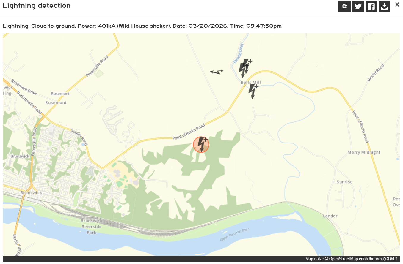
One things for sure... The common non-weather folks sure weren't expecting thunder last night. ...

-
Yes can confirm. weather.us Always like that site for figuring out how powerful certain lightning events were.
-
Yeah. A 401kA positive bolt would certainly do that.
-
Yeah pretty sure I just heard a deep rumble near 5 minutes ago all the way down in Herndon, VA.