Cobalt
-
Posts
5,218 -
Joined
-
Last visited
Content Type
Profiles
Blogs
Forums
American Weather
Media Demo
Store
Gallery
Everything posted by Cobalt
-
RGEM made a pretty substantial shift as well
-
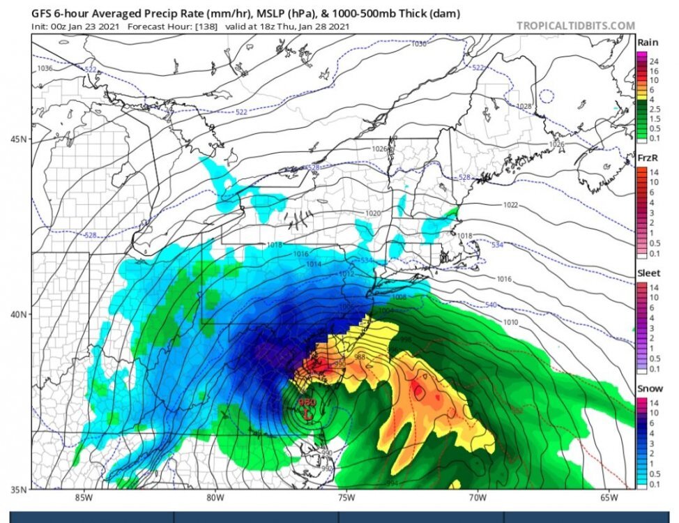
Hey friends, I've been in a coma since January 23rd, 2021, and just woke up. I'm curious, did the storm depicted on the GFS work out? It seemed like a really huge bomb! I don't think it had much consensus, but the model seemed insistent on developing a storm that bombed out over the mouth of the Potomac.
-
What a time to be living in the ocean
-
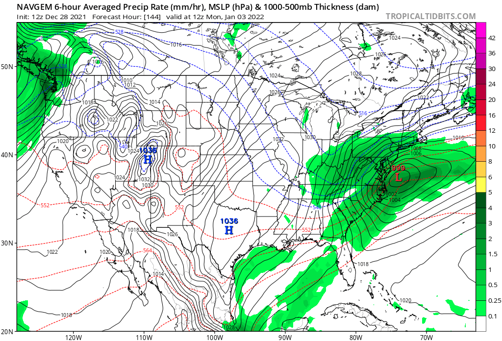
One of the first cases of me understanding model bias was when I was told that the NAVGEM had an apparent "suppression" bias. This was back in 2017, but in every single instance where an image of the model has been posted, the storm is depicted more AMPED than other guidance. Is this me misremembering, or is this not a continuous occurrence?

-
Still waiting for his "1996" pattern from this time one year ago to come to fruition.
-
I like seeing that initial D5 system trending towards scooting out of here faster, it allows confluence to build ahead of that intriguing system..
-
Obviously it's entering LR territory, but 0z GFS drops a 1045hp into the Great Plains through hr 180.. some serious cold entering the central tier of the country after that D8 storm system. Seeds of change?
-
The Euro weeklies are.. not exactly the most enticing. Somewhat serviceable for the first week of January I suppose, but coupled with the incredibly persistent -PNA, it looks like the waning neg NAO results in the SE ridge really flexing its muscles after that point. Looks like a less favorable Atlantic has been the trend for the past few days in the LR.
-

December 2021 Medium/Long Range Discussion Thread
Cobalt replied to North Balti Zen's topic in Mid Atlantic
Nice to see that pretty stout 50/50 signal too.. -
December 2021 Medium/Long Range Discussion Thread
Cobalt replied to North Balti Zen's topic in Mid Atlantic
Pretty decent agreement among the Canadian, GFS, and Euro ensembles for the timeframe into very early Jan. Much like with the fabled D10-15 blocking pattern presented on the models in early Jan of last year, it seems like we'll have to wait a while for those effects to show up in the medium range, only this time we're looking at that pattern shift 2 weeks earlier. -
The Blessed Torchember Friday 12/17 Event for 70+ Temps
Cobalt replied to H2O's topic in Mid Atlantic
-
RGEM holds steady
-
For a time.. that'd be cool, and we'd be chilling. Eventually though, we'd have to face the cold hard facts.
-
I recall you saying that you hadn't gone a winter without a warning level snowfall since 01-02 and that you were overdue..
-
Reaper watch > winter storm watch
-
18z agrees
-
If anyone had BWI for 11/4, they would've.. guest correctly
-
The Braves winning the World Series for the first time since October 1995 gives us a clear top analog for this upcoming winter #itshappening
-
It's all fun and games until DT comes in and gets in an all-out brawl with Ji
-
The mesos have been pretty bearish about sub-freezing cold at the surface tonight, but suggest tomorrow night might have a better chance
-
Yeah, I'm not too familiar, how would moderation/verification go for those calls? It would be a shame if someone joined pretending to be someone else, only to end up being deliberately disruptful.
-
This is entirely true, Zoom does seem like the best option.
-
Discord is always an option, as it has built in video calls, but it might be a bit tougher to set up/facilitate.
-
the ICON is insistent that we get some cold rain from the #snoreaster