Cobalt
-
Posts
5,215 -
Joined
-
Last visited
Content Type
Profiles
Blogs
Forums
American Weather
Media Demo
Store
Gallery
Everything posted by Cobalt
-
Enjoy it for another hour and a half
-
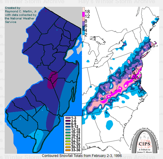
I mentioned that the axis of snow felt reminiscent of a random snowstorm accum map I saw from 95-96, and I just now found the match. Hmmmm The northern cutoff is drastically different but ofc you can't have it all
-
-
Not sure about DC, but I recorded 1.6" on 1/17/19, 4 days after DCA recorded a double digit snowfall. I could probably find the total, but that seems like the last time. A lot of our recent futility stems back to the period after the 18-19 winter.
-
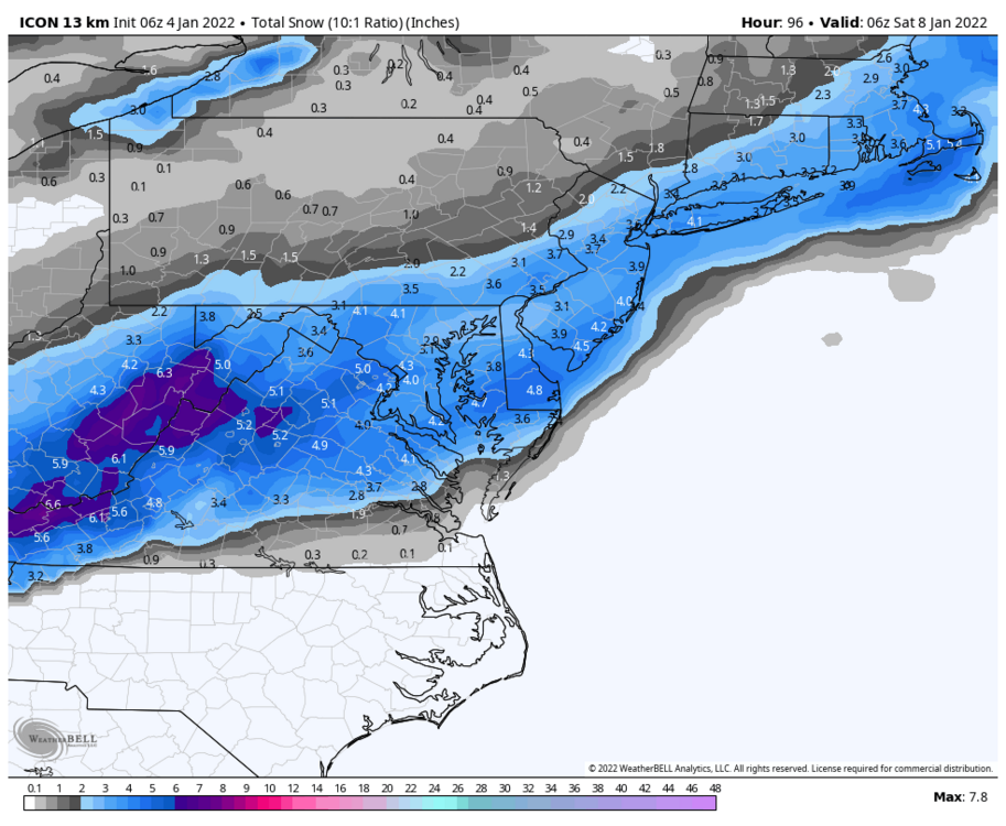
ICON likes snow for Friday
-

Mid-Atlantic forum winter 2021/22 snow totals thread
Cobalt replied to North Balti Zen's topic in Mid Atlantic
1/3 - 6.5". Fast moving snow bomb. 5" in 4 hours, areas to SE eclipsed double digits. 1/7 - 3.8". Speedy redeveloper w/ a miracle snowband, 1.6" in just one hour. 1/16 - 2.6". Frigid powder turns to sleet/rain with wicked winds. 1/29 - 0.8"*. Season Total: 13.7" * = Based on spotter reports -
6.5" final. Biggest La Nina snowfall since Jan 26 2011 (8.1"). 5" fell from 8am-12, including 2"/hr rates for part of that duration. Great storm, can't wait for the deep winter conditions tonight and tomorrow morning. Oh btw, I completely forgot to change my location back to McLean due to winter break. Apologies
-
5.8” as of 11am. Firmly into WSW criteria. The back end is close, but that band pivoting through DC looks like it might give us some action. Glad to hear that the SE peeps cashed in, great event for you guys!! .
-
3.6” now, so 0.8” in the last 30 minutes. Keeps getting heavier too. .
-
2.8” in McLean as of 9am. Would not be surprised to be exceeding 4” within the hour, heavy snow with yellows on the doorstep. 1.3” from 8 to 9. .
-
lol i'm sure they have. Thank you for making snow measuring a competitive sport!
-
How's the event holding up for you in Chesapeake?
-
Winter storms bring out some of the most interesting characters on this board.
-
Jan 12-14 2019 produced 10" at DCA, it was long duration storm, albeit with light rates for most of the event.
-
March 2014 for sure, that was upper 60s in mid march sun. Cooled down pretty handily with dews crashing shortly after sunset...
-
Might be the weenie in me, but at this time during storms where we're on the SE fringe, we look to the HRRR to have a colder and more SE solution compared to general guidance. I definitely remember this for our sleet bomb last February.
-
Part of this could be due to the fact that 0z still had some rain from overnight impacting totals Ninja'd
-
3/17/2014 as well. The environment leading into the event is pretty similar to this, as temps peaked in the 60s the day before with precip onset after nightfall. Fairly different setup overall but that definitely surprised some.
-
3k NAM agrees
-
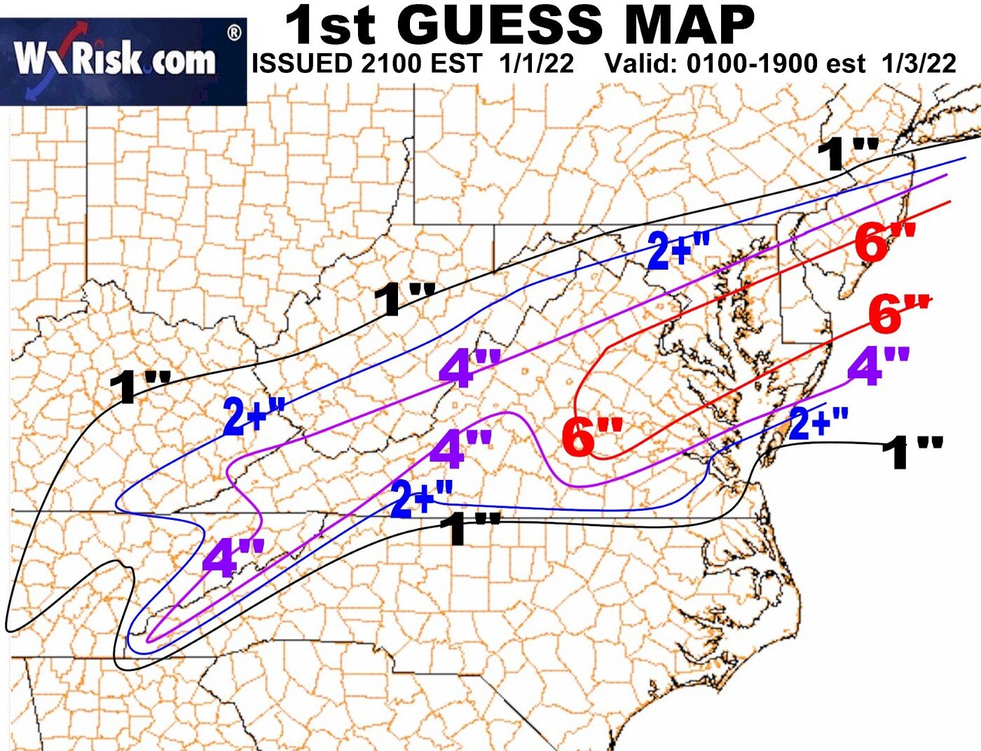
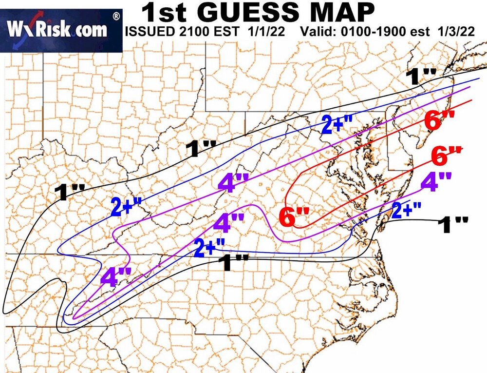
DT's first guess map. Bit of a banterish observation, but this seems to resemble some of the medium-sized events from Feb 1996, no? I recall seeing a few that bullseyed SE of DC in this fashion.
-
Here's a quick visual comparing the 0z Euro to the 0z EPS. It's hard to tell since it's overlayed on top of the EPS, but the big L represents the operational. A fair bit of lps NW of the mean, and of course there's the cluster well offshore, but that scenario seems to be dwindling with every model cycle.

-
Probably the most significant shift out of any non-meso compared to its 12z counterpart. Still not as amped as others, but takes the 1" snow line into DC.
-
RGEM made a pretty substantial shift as well
-
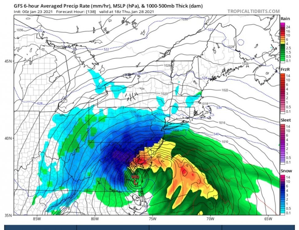
Hey friends, I've been in a coma since January 23rd, 2021, and just woke up. I'm curious, did the storm depicted on the GFS work out? It seemed like a really huge bomb! I don't think it had much consensus, but the model seemed insistent on developing a storm that bombed out over the mouth of the Potomac.