DownpourDave
-
Posts
1,353 -
Joined
-
Last visited
Content Type
Profiles
Blogs
Forums
American Weather
Media Demo
Store
Gallery
Everything posted by DownpourDave
-
-
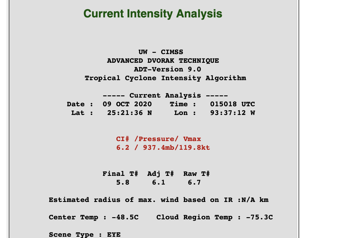
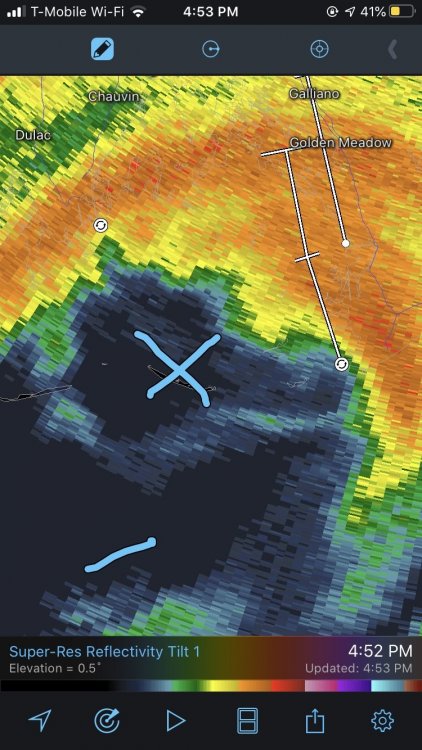
btw it has made landfall it seems or nearly at that. Eye is clearly over one of the outer islands.
-
radar velocities up to 140 mph 8,000 feet up. 115 mph is definitely defendable for the surface.
-
Upstate/Eastern New York
DownpourDave replied to BuffaloWeather's topic in Upstate New York/Pennsylvania
Maybe ill drive to Albany and chase this. Nothing better to do anyway. They look to have a better chance at getting something good anyways -
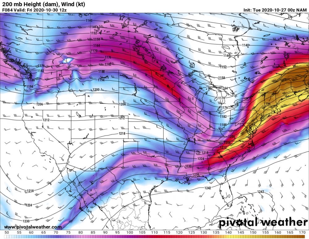
I wish there was a low location overlaying this panel. But you can clearly see the favorable positioning of the low pressure positioned to the right entrance of the jet streak promoting ascent. I have no doubt with the upper-level support, the low pressure system would have continued to strengthen if there had been more panels. after 84 hours.
-
Upstate/Eastern New York
DownpourDave replied to BuffaloWeather's topic in Upstate New York/Pennsylvania
my post was not meant to be taken seriously. I thought it was pretty clear I was being facetious -
Upstate/Eastern New York
DownpourDave replied to BuffaloWeather's topic in Upstate New York/Pennsylvania
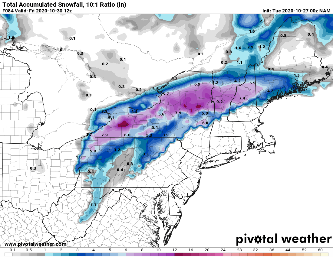
cmon guys you all knew it was coming! nam'd Totals with the event still well-underway.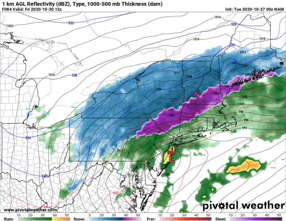

-
Upstate/Eastern New York
DownpourDave replied to BuffaloWeather's topic in Upstate New York/Pennsylvania
so not a "big step down" but definitely a trend in the wrong direction. Weaker lighter precipitation vs 18z. -
Upstate/Eastern New York
DownpourDave replied to BuffaloWeather's topic in Upstate New York/Pennsylvania
almost an hour later and still stuck at 36 hours strange. -
Upstate/Eastern New York
DownpourDave replied to BuffaloWeather's topic in Upstate New York/Pennsylvania
early, but thinking the gfs-p will be a big step down. Just looking what I am seeing so far. Could be wrong ofc. -
Upstate/Eastern New York
DownpourDave replied to BuffaloWeather's topic in Upstate New York/Pennsylvania
best map I could find from euro eps. Feel free to react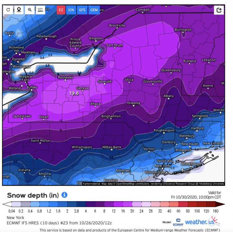
-
Upstate/Eastern New York
DownpourDave replied to BuffaloWeather's topic in Upstate New York/Pennsylvania
I want to add that any measurable snow in October is win at least for me. Even if we just get 1 inch. -
Upstate/Eastern New York
DownpourDave replied to BuffaloWeather's topic in Upstate New York/Pennsylvania
GFS-p looks pretty good. Snowfall maps are not out yet but looks like it would be 4-8 inches area wide when they do come out. -
Upstate/Eastern New York
DownpourDave replied to BuffaloWeather's topic in Upstate New York/Pennsylvania
@wolfie09 you will like the euro!!!
-
Upstate/Eastern New York
DownpourDave replied to BuffaloWeather's topic in Upstate New York/Pennsylvania
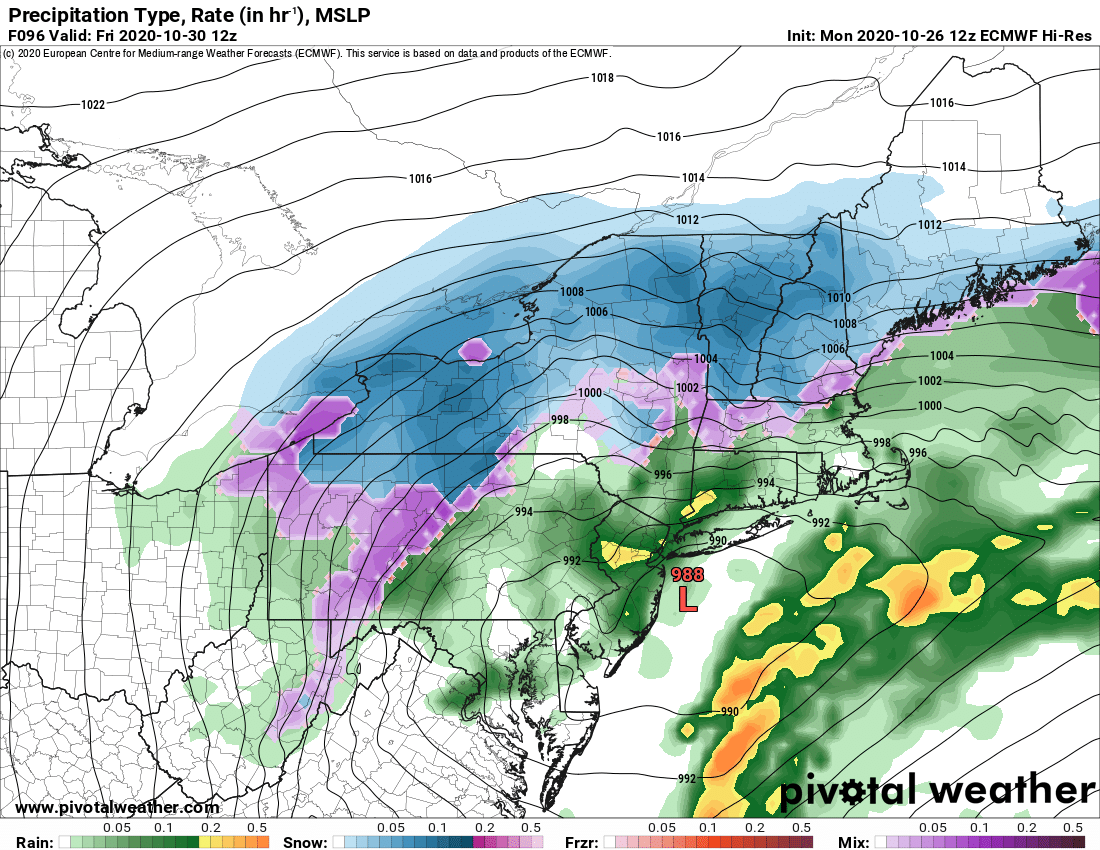
Too bad not all of it is snow. Over 2 inches of QPF, if this same thing happened literally just a month later it would be a historic 1.5 foot + snowstorm as depicted on the Ukie. -
Upstate/Eastern New York
DownpourDave replied to BuffaloWeather's topic in Upstate New York/Pennsylvania
Might be time to buy an ice scrapper for my car. Shame.....I was hoping I could hold off another month. -
Upstate/Eastern New York
DownpourDave replied to BuffaloWeather's topic in Upstate New York/Pennsylvania
Anyone have vertification scores for the gfs-p. Is it any good at all? -
Upstate/Eastern New York
DownpourDave replied to BuffaloWeather's topic in Upstate New York/Pennsylvania
GFS-p is still interested -
What is the difference between CAPE and MAX THETA E CAPE.
-
Upstate/Eastern New York
DownpourDave replied to BuffaloWeather's topic in Upstate New York/Pennsylvania
Location/ name of trail? view looks amazing that's why I ask -
Upstate NY Banter and General Discussion..
DownpourDave replied to wolfie09's topic in Upstate New York/Pennsylvania
Dude this is a bad a take. -
tropical cyclone/transitioning giving a foot of snow. That would be a first. I wonder would you even call this a nor'easter. Technically it is a tropical cyclone hybrid.
-
That's a little complicated to be certain. Granted, speculation here; but two points: 1) It would not have needed a full day at the rate the pressure fall it was experiencing into landfall to have become a more intense. Between 4:30AM and 10:30AM CDT recon missions recorded a pressure drop from 937 mb to 923 mb. The last pass recorded 919 mb at 12:30PM CDT. A mere six more hours over those above-normal GOM SSTs and exquisite upper tropospheric conditions and it would have likely bottomed out around 910 hPa, taking into account some leveling off as well. At that rate of pressure fall and gradient increase, even nine more hours we would have seen Michael flirt with 150-160 kts (175-185 mph) winds. 2) On the other hand, the eye was also contracting and a concentric band was beginning to form. So given too much more time, very probable that an ERC would have most likely initiated given another full 24 hrs, and we would have likely seen Michael level off and weaken. Yeah and I guess it was flirting with MPI so it couldn't have strengthened too much more. Would have naturally leveled off........ even without an ERC.
-
I know it was intensifying up until landfall. One can wonder how much stronger it would have gotten if it had another day over water. 185 mph? 190 mph?
-
Obviously just another data point< Hurricane Hunter Data but interesting anyways.