DownpourDave
-
Posts
1,353 -
Joined
-
Last visited
Content Type
Profiles
Blogs
Forums
American Weather
Media Demo
Store
Gallery
Everything posted by DownpourDave
-
January Storm Term Threat Discussions (Day 3 - Day 7)
DownpourDave replied to WxUSAF's topic in Mid Atlantic
Tropospheric Polar Vortex -
January Storm Term Threat Discussions (Day 3 - Day 7)
DownpourDave replied to WxUSAF's topic in Mid Atlantic
it is significantly further south suppressing the heights. Important frames upcoming. -
January Storm Term Threat Discussions (Day 3 - Day 7)
DownpourDave replied to WxUSAF's topic in Mid Atlantic
this is part of what we should keep in mind for the 00z runs tonight. Ideally, we want the TPV to be out of the way but if that cannot happen the next best thing is to get it positioned more favorably. Having the TPV positioned further west allows better heights out in front of the shortwave.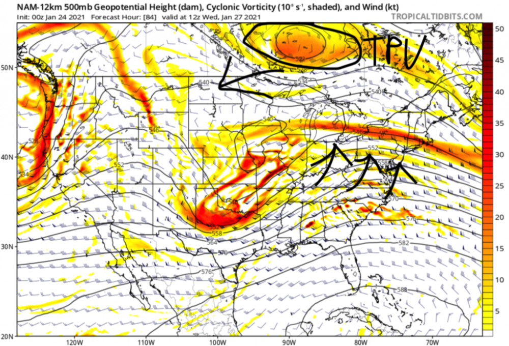
-
it is frustrating when you think about it. This same exact winter 130 years ago probably would have produced already double digit snowfall for the season by now. You remember that storm back in December where you mixed to sleet, that would have been all snow for you and you would have gotten probably a foot of snow out of it. And now that I am thinking about it with a colder background state, the baroclinic zone would have been further south for that storm so I am sure some of these misses to the north so far this winter would not have been back then.
-
update: From Washington Post, imrs.php-2.jp2 It is easy to see the decline. Seems like 10-15 more inches on average would have been a good bet for early 1800s extrapolating the trend-line back a little further.
-
I always have wondered what experiencing winters pre-industrial revolution climate would have been like. My guess is DC in the 1800s averaged at least 10 more inches of snow but would have look at the data.
-
January Storm Term Threat Discussions (Day 3 - Day 7)
DownpourDave replied to WxUSAF's topic in Mid Atlantic
also the TPV up in Canada is in a better location vs 12z gfs. Should be less suppressive. -
January Storm Term Threat Discussions (Day 3 - Day 7)
DownpourDave replied to WxUSAF's topic in Mid Atlantic
my guess is positive feedback loop. The warmer it gets the less snow there is so it is able to get warmer even faster. Also it being a la Nina is a factor. I think we can all agree that a el Nino with a -AO/NAO would have produced a colder result for us. If I am wrong someone please chime in. -
January Storm Term Threat Discussions (Day 3 - Day 7)
DownpourDave replied to WxUSAF's topic in Mid Atlantic
the shortwave is digging slightly less. My guess this ends up slightly worse than 6z but still way better than the euro. -
January Storm Term Threat Discussions (Day 3 - Day 7)
DownpourDave replied to WxUSAF's topic in Mid Atlantic
That ULL that you are talking about on the icon is further south on the 12z gfs vs 6z. Hope that is not too bad of a sign..... -
January Storm Term Threat Discussions (Day 3 - Day 7)
DownpourDave replied to WxUSAF's topic in Mid Atlantic
It will not allow me to post another attachment. I will have to clear later. So to finish up this post, I was going to show the gfs which clearly shows the PVA being NW of the euro which allows for the best precipitation to be over the DC area and points northwest.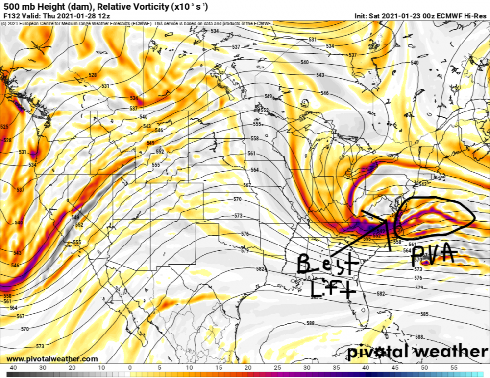
-
January Storm Term Threat Discussions (Day 3 - Day 7)
DownpourDave replied to WxUSAF's topic in Mid Atlantic
@NorthArlington101 not digging as much and less amplified go hand in hand generally. A shortwave that does not dig will generally not be amplified as a shortwave that really digs especially if it is able to tilt negatively. -
January Storm Term Threat Discussions (Day 3 - Day 7)
DownpourDave replied to WxUSAF's topic in Mid Atlantic
it is already clear at 96 hours that the euro will not be like the gfs. Shortwave is not digging as much out west. -
January Storm Term Threat Discussions (Day 3 - Day 7)
DownpourDave replied to WxUSAF's topic in Mid Atlantic
out west through 84 hours the euro and gfs actually look remarkably similar. The differences I see is that the shortwave is more amplified on the gfs vs the euro. PV is in a similar placement on both models. -
I suggest not looking at the ukie. Good time to call it a night.
-
January Storm Term Threat Discussions (Day 3 - Day 7)
DownpourDave replied to WxUSAF's topic in Mid Atlantic
I am looking at the h5 track after it is off-shore. It looks like the lobe helps to bring the h5 low of our storm northward with the interaction so we want that to happen sooner I assume for the coastal to have a more Northern track closer to the coast? -
do you enjoy giving bad news? there are many other examples.
-
Feb Long Range Discussion (Day 3 and beyond) - MERGED
DownpourDave replied to WinterWxLuvr's topic in Mid Atlantic
It seems like you are saying this pattern cannot get much better. Like what is the upside? I would assume a Jan 16' type storm is possible in this pattern if it really is the best possible pattern we can get that would only come once a decade. -
lol I do not know what I would do if the numbers that are drawn appears in one of the posts here.
-
96 is not a possible number. It is 1-70 for the white balls.
-
15-33-19-11-5-17 btw, this is my 777th post (was not planned) and the number 777 is used on most slot machines in the United States to identify a jackpot. Take that for what it is worth lmao.....
-
what the hell is wrong with the NE forum lmao

-
I was 16 when I first joined the forum. I have to admit, I learned quickly quantity is not nearly as good as quality. My posts are few and far between (26 total posts) between December 15th- January 15th. And used to post much more frequently with little value. Presently, having taken quite a few college-level meteorology courses have helped with most recently taking an upper-level mesoscale meteorology course which will hopefully allow me to contribute when we get to severe weather season as it seems that the most important aspects of severe weather do happen on the mesoscale with there obviously being synoptic components. Lastly, I have not yet taken Synoptic meteorology which is why I still am not great with posts in regards to winter weather threats but I hope to be able to take that course next year. I hope to be able to contribute more as I continue my education in meteorology.
-
Feb Long Range Discussion (Day 3 and beyond) - MERGED
DownpourDave replied to WinterWxLuvr's topic in Mid Atlantic
Good call. The primary hangs on a tad too long for your area and probably even mine. Extrapolating, I am sure it would have been a great run for interior New England . H5 track is just a bit too far north. But we do get a little bit of blue so there is that.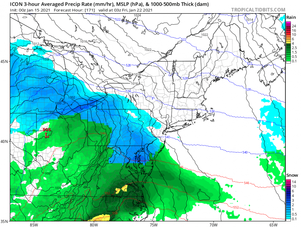
-
It seems like he is saying that the climate is controlled by the manipulation of people to do certain actions that would affect the earths climate. I have no ****ing clue lol. Just a wild guess.