Paleocene
-
Posts
2,050 -
Joined
-
Last visited
Content Type
Profiles
Blogs
Forums
American Weather
Media Demo
Store
Gallery
Everything posted by Paleocene
-

Feb 22nd/23rd "There's no way..." Storm Thread
Paleocene replied to Maestrobjwa's topic in Mid Atlantic
Wasn't done yet in my last image. RIP my roof.
-
Feb 22nd/23rd "There's no way..." Storm Thread
Paleocene replied to Maestrobjwa's topic in Mid Atlantic
LOL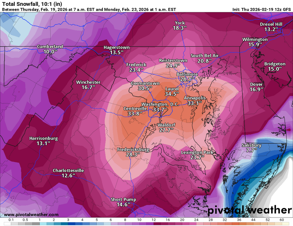
-
Feb 22nd/23rd "There's no way..." Storm Thread
Paleocene replied to Maestrobjwa's topic in Mid Atlantic
coast low gets captured/stalled/tucker mctuck and we get annihilated. It literally parks over us -
Feb 22nd/23rd "There's no way..." Storm Thread
Paleocene replied to Maestrobjwa's topic in Mid Atlantic
No but I do know that the NAM is running. At this point I trust it just as much as the GFS! Let's get hyped folks -
Feb 22nd/23rd "There's no way..." Storm Thread
Paleocene replied to Maestrobjwa's topic in Mid Atlantic
Zoomed in 18z europe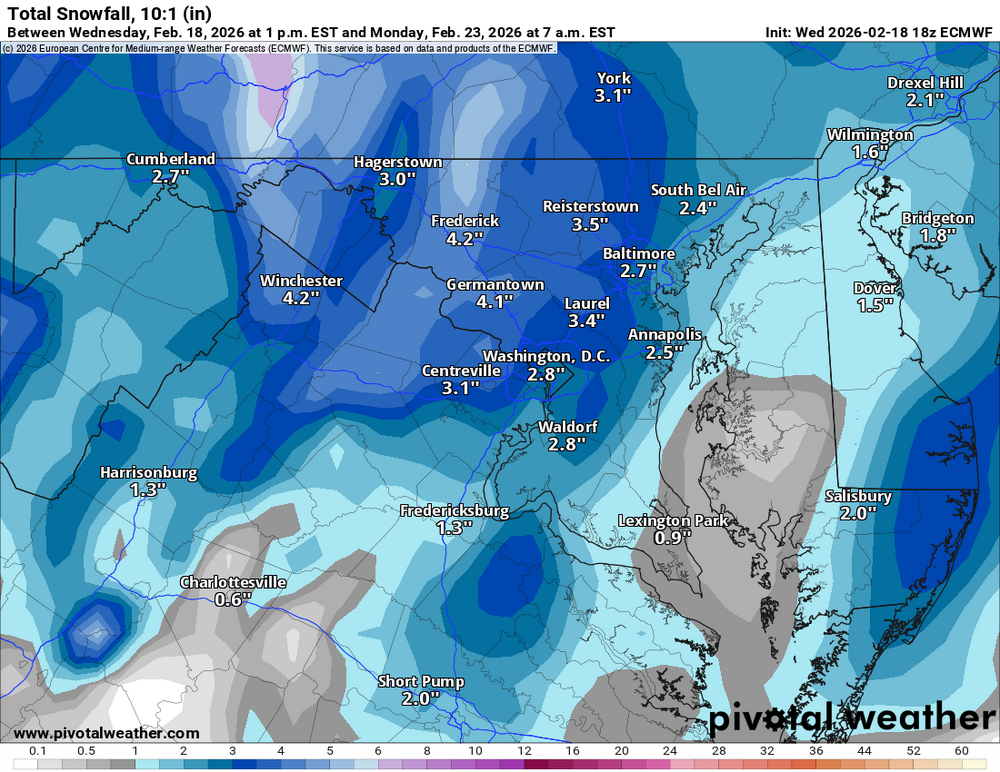
-
Feb 22nd/23rd "There's no way..." Storm Thread
Paleocene replied to Maestrobjwa's topic in Mid Atlantic
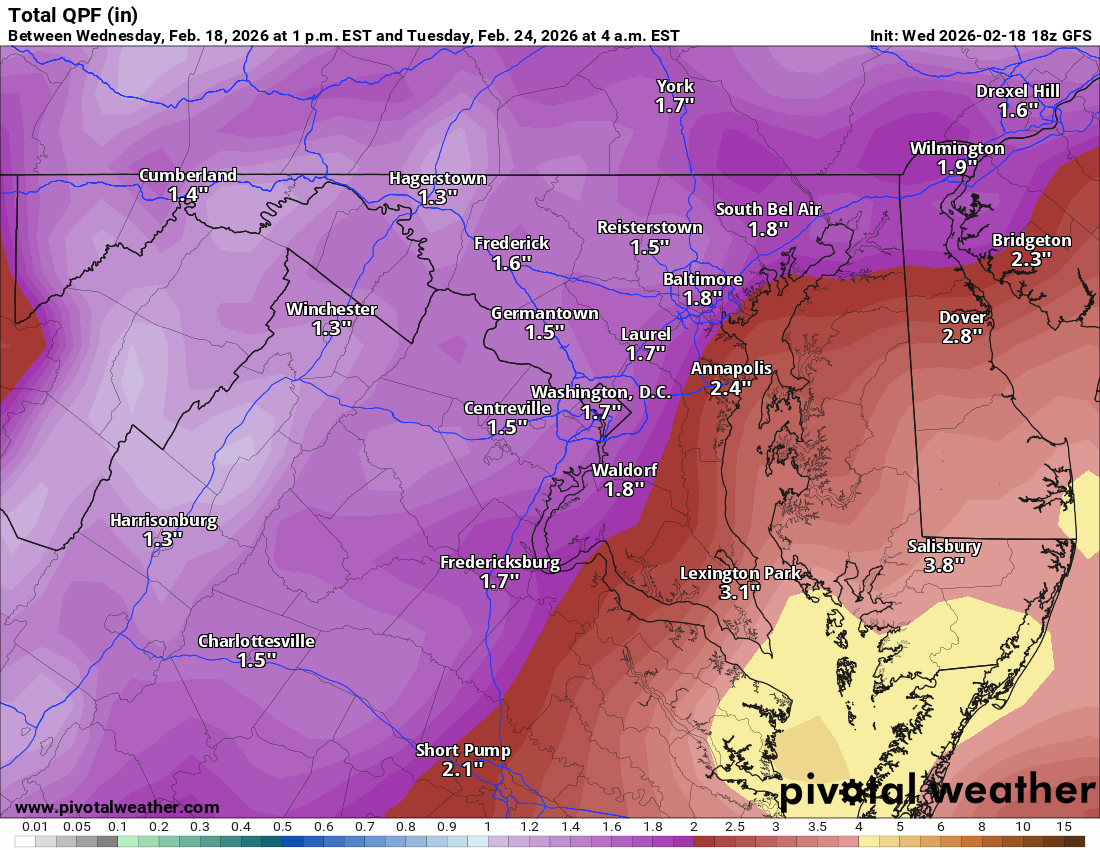
Ah you're right, sorry. I've been so PUMPED looking at our imaginary storm I forgot it may rain this week. Will got the right map. Reposting for clarity. Still absurd numbers -
Feb 22nd/23rd "There's no way..." Storm Thread
Paleocene replied to Maestrobjwa's topic in Mid Atlantic
@mappy lol. Yes, that's over 4" in the southern portion of the bay. Happens all the time in February.
-
Feb 22nd/23rd "There's no way..." Storm Thread
Paleocene replied to Maestrobjwa's topic in Mid Atlantic
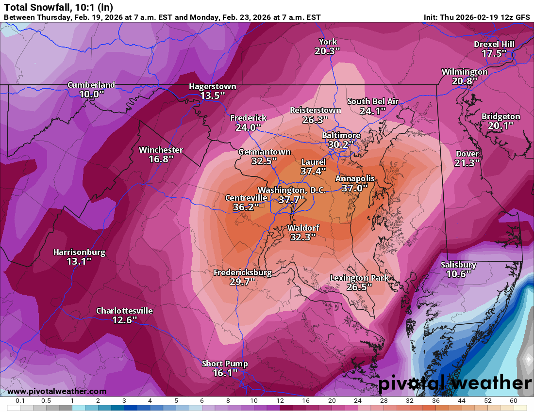
One for the digital snow memory books.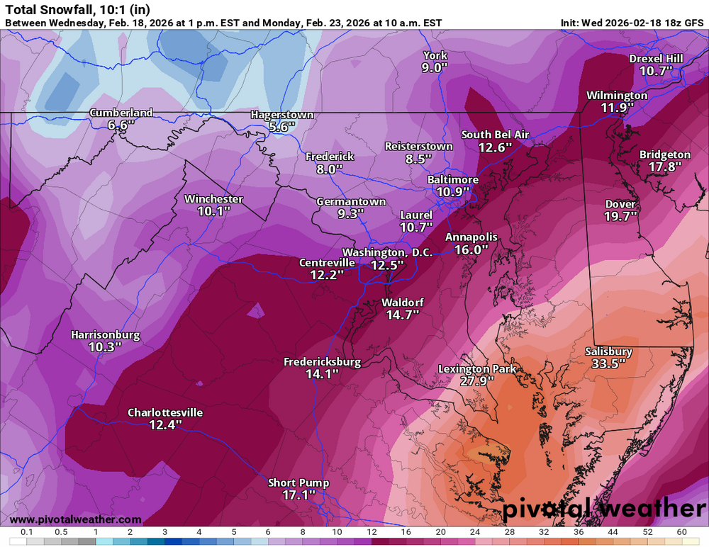
-
Feb 22nd/23rd "There's no way..." Storm Thread
Paleocene replied to Maestrobjwa's topic in Mid Atlantic
lol. 976mb east of Norfolk. Rekkage -
Maestros
-
Temps on the gfs are marginal for the cities. As in above the margin lol. Love the track tho
-
Awww did my Harrisburg joke get removed? Too bad. But I shouldn't muck up the LR thread with geographical insults.
-
lol @bncho putting this here instead of the mess of a thread we are currently having. i asked GPT to draw a +PNA and even it got it right (sort of.. minus the bi-directional jet stream, the states of Neorgia and South South Carolina, and new Newfoundland East)
.png.b8710268a4758069d81ec66f36d2af50.png)
-
Lol the GFS just dropped like two feet of sweet digital snow on the eastern shore I would qualify that as a big storm
-
Time for the 18z runs to pull us all back in. So that we can all bail tomorrow with a 12z fail
-

-
New Jersey gets annihilated by the germans
-
Foggy as heck here in the northern DC burbs. Strange to see the thick fog, that is such a usual feature of our warm wet Winters that we typically have. But it's been so dry. I feel like I haven't seen heavy fog since the fall. Still decent snow cover in my backyard which is pretty amazing for this area. 23+ days
-
start the thread jk
-
EPS and AI EPS are both damp and cold next weekend. And potentially snowy, but looks miller-b with better luck to PA and north. Enough to keep me intrigued for another week for sure
-
Shucks. Pdiii(once removed)
-
Pd3. It's happening
-
Lol I was going to make a similar post but tried to stay positive for bunchos sake. Lots of posts for some gentle showers
-
Looking forwarded to my heavy rain
-
GFS going down with the ship lol