Paleocene
-
Posts
2,050 -
Joined
-
Last visited
Content Type
Profiles
Blogs
Forums
American Weather
Media Demo
Store
Gallery
Everything posted by Paleocene
-
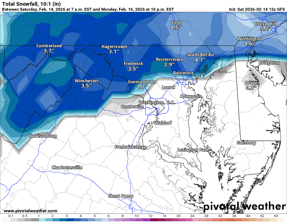
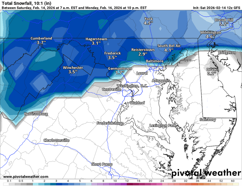
18z NAM says enjoy your front end thump of rain, for the entire MA forum. Temps torched; freezing line way up in northern nj/nyc area. 3k is much the same. well at least our cars will get washed off?
-
I'm impressed with how my snowpack is holding on here. But it's nice to have some days with real solar panel production. Gotta make up for some steep january usage on the ole heat pump
-
 Trust me, we used to fail. I had a few disappointing winters in the 90s as a kid (and some great ones), and I lived further north. Now we are more likely to fail!
 -
Zoomed in version. Less aggressive than 6z was. Believable but everyone is gonna be sweating thermals. Time period is late afternoon into evening tomorrow so sun angle won't cook as much
-
GFS good for PA folks. And north of i70 too I suppose
-
Gfs still drops a bit of snow for mason-dixon
-
Just opened this thread after not looking since the 06 6z Euro, and... Damn it. I'm still in
-
Lol this thread
-
I haven't given up yet. The track keeps me intrigued, and the moving parts (maybe something will go right for once instead of wrong as with recent NC storm). And the simple fact that we have barely gotten any moisture since the snow/sleet beatdown storm. But like with the Euro image i posted above, I'm very worried about temps for my backyard even if the track trends toward "perfect." Silver Spring doesn't do marginal well.
-
It's good when the storm has banana low pressure around it right?
-
Let's gooooooooooo I'm not out.... yet 18z icon is a rain miss South
-
PSU's sensors are about to go off. Did you know we get 98.985% of our seasonal snowfall in March?
-
If you like rain the 6z euro is choice
-
Agreed!. I have an inordinate number of photos of trees/woods taken between 12/10 and 12/31 each year lol. Love that soft light. Even better the further north you go
-
Paleocene's Sky Stuff Rankings (I like the I guess) 1) Extremely low AQI / high pressure days with zero cloud cover and deep blue sky, particularly from July - October (but also other months) 2) Sunny days in February - March when the sun angle starts increasing but the leaves aren't out yet, and everything is lit very brightly in profile by the still angled rays of the sun, especially houses/buildings/trees. See paintings by Edward Hopper (my prof pic). Shadows are pronounced. 3) Obligatory SN+ 4) When it absolutely rains buckets and sheets of rain and it's like we're in south florida
-
I got like an inch of rain that one day after new years. then 1.5" of snow and pellet precip. but yeah other than that dry as a bone
-
miss south
-
CMC. Flips to rain for metros
-
Lol one piece of the low on the GFS ends up stuck in Tampa
-
yeah if the op euro is just chasing the AIFS which has consistently been south we're cooked.
-
Indeed. 06z euro says wake up mid Atlantic and don't shit the blinds just yet!
-
Now there's how the MA does February. Enough of these Manitoba temps
-
18z icon looks like it'll take the ol' northerly route up to michigan if it went past 120 hours. love that <3
-
Meh. For 48 hour QPF at D7+ I would expect some pretty major dispersion. If it looked like this inside D5, I would agree with you.
-
Which results in some major differences lol. Euro 12z precip Euro AI 12z precip (it's faster so slightly earlier panel)