Paleocene
-
Posts
2,050 -
Joined
-
Last visited
Content Type
Profiles
Blogs
Forums
American Weather
Media Demo
Store
Gallery
Everything posted by Paleocene
-
 Real gullywasher in Silver Spring - dumpage for a solid 15 - 20 mins. Yard pondage
 -
It's been 98% cloudy in silver spring today with a few peeks of brightness. Looks like the southern line rolling through FFX may be headed towards DC/me.
-
Tree branches down all over the place in silver spring. I guess lots were weakened by heavy wet snow this month and last. And our very cold winter and recent freeze/thaw/boil cycle.
-
Getting smoked with rates for the past hour plus in zip code 20740 (college park/riverdale MD)
.jpg.45b0de2fc8cbbd33ec37a359f990f348.jpg)
-
Snain in college park/riverdale
-
i'm locked and loaded, zoom in 12z euro. guaranteed to happen. especially because all of this is forecast for between about 9am and 5pm
-
Torchy mctorch today
-
Here in UHI world I think we are a solid 14+ days behind where we have been in the past several winters. We have a lot of crocuses blooming in random sunny spots in parks; in past years, those bloomed as early as Feb 18th-24th.
-
I'm ready for another four inches of sleet
-
Meh. May and June have been cloudy and damp of late here. I want sun This weather is grim
-
We excel at fog and wind. For a while there we excelled at rain, but it's been sort of dry for a while
-
No arguments here. We need some sunshine.
-
Outta gas and Outta Time: Early March Winter Storm finale
Paleocene replied to Ji's topic in Mid Atlantic
Seems like that back edge is coming east pretty fast for round one here. -
Outta gas and Outta Time: Early March Winter Storm finale
Paleocene replied to Ji's topic in Mid Atlantic
Deathband that was over me has lightened up a bit since 215pm or so; lighter flakes now. But last few frames have the hole filling in, at least over DC? -
Outta gas and Outta Time: Early March Winter Storm finale
Paleocene replied to Ji's topic in Mid Atlantic
I've been on the southern edge of the northern band in Silver Spring for 2 hours -- started snowing moderately at 1215pm. This escalated quickly..jpg.6e8dd78e6c11e1900ef3462b41639bb8.jpg)
-
Outta gas and Outta Time: Early March Winter Storm finale
Paleocene replied to Ji's topic in Mid Atlantic
Been under moderate snow for about 45 minutes near downtown Silver Spring. A classic white rain/mulch accumulation. Not sticking to much, but looks gorgeous. Big flakes. -
Outta gas and Outta Time: Early March Winter Storm finale
Paleocene replied to Ji's topic in Mid Atlantic
15z HRRR does a total DC split this afternoon, lol -
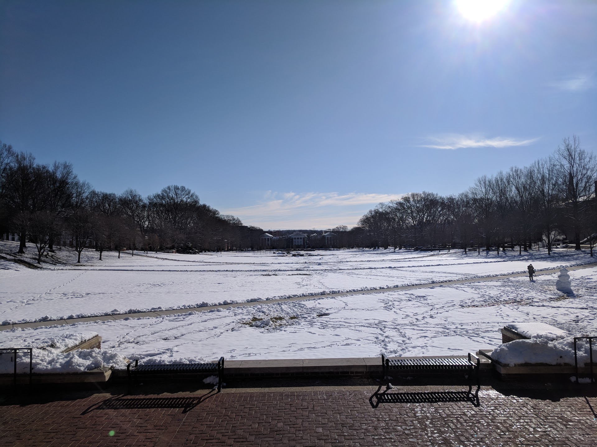
Fair enough. I am generally willing to concede March 1st - 15th as winter in the DC beltway area but after the 15th... we need luck. Of course there was 2014 (St. Patrick's Day), and then in 2018, we had snow March 21 which stuck around for a day. Here's McKeldin Mall at UMD on the 22nd of March 2018, after we got about 3-4" the day before, I think. 2 years out of the last 12 == enough to not rule it out after the 15th, I guess.

-
tracking heat
-
Winter is cooked. I'm direct sowing some cold season veggies in my sunny garden beds today. Spring has won.
-
Yes, they're rising from their winter graves in my nhood here in the burbs
-
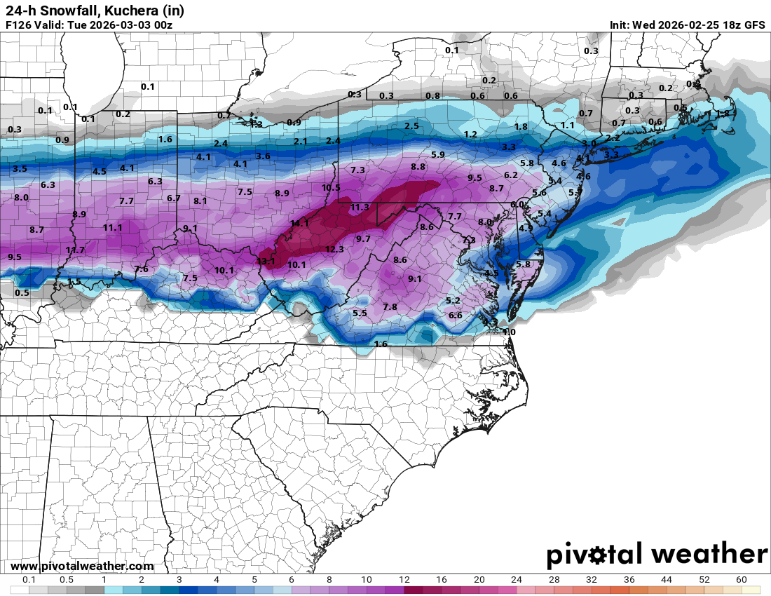
I am also ready for the torch. Once we hit March 1st, my enthusiasm for tracking is gone. This map looks great.
-
Outta gas and Outta Time: Early March Winter Storm finale
Paleocene replied to Ji's topic in Mid Atlantic

-
Outta gas and Outta Time: Early March Winter Storm finale
Paleocene replied to Ji's topic in Mid Atlantic