

Scarlet Pimpernel
-
Posts
7,345 -
Joined
-
Last visited
Content Type
Profiles
Blogs
Forums
American Weather
Media Demo
Store
Gallery
Posts posted by Scarlet Pimpernel
-
-
3 hours ago, Eskimo Joe said:
Jan 26, 2011 is in my Top 5 weather events of all time. I was in Lancaster at the time and remember how powerful the front end thump was impressive. Then we just snizzled all day before the afternoon thump came in hard right at sunset. Looking back at the after action reports in our work library, apparently OPM issued an early departure mandate, but it wasn't enforced my mid level managers. Everyone in DC proper was looking out their window and seeing drizzle thinking it would be a bust. It wasn't until the spouses started calling from home and relayed conditions in the suburbs getting so bad that everyone bailed. By then it was too late. That's why you see language now on PM early departure notices that say "managers must dismiss staff no later than X time".
(moving to Banter...)
Definitely a high-impact event! What you describe is more or less what I got at my place at the time in Silver Spring. There were a couple of inches on the ground early morning on the 26th, then the snizzle for several hours, then WHAM! late afternoon and evening. It was unreal. I got home just in time when the main part hit. It started quite literally like small chunks of ice for a short while (not the standard sleet balls, probably icy flakes), which quickly turned into heavy, wet snow. As I said in the other thread, we received 8" in about a 5 hour period, a total paste job. Very picturesque and stunning from a scenic standpoint. But also quite destructive as well, with the power outages and downed tree limbs. I lost power for almost 3 full days and it was pretty miserable to be honest. It actually got down to like the mid-upper 40s in my apartment by the time power was restored. If the power didn't come back when it did, I was giving serious thought to finding a hotel...though a lot were already full since many people were grabbing rooms for the same reason. I was able to go into work the next day and beyond, so was able to be in a decently warm building much of the day while my power was out!
You're right, a lot of people initially kind of shrugged even after the NWS hoisted the warning, because it looked drizzly outside and not much happening. I recall OPM did finally send people home. Can't recall exactly how that went down but I think it was something like granting 2 hour early dismissal, but everyone leaving NO LATER than 3PM. I left around or just before 3PM. Fortunately my commute wasn't bad and I'm not far away from work. In hindsight, they should have let everyone out at like noon or 2PM. Plus, a lot of other businesses, etc., didn't close up or allow people to cut out early to avoid the inevitable mess, or they only did so very late. So at 3PM and beyond, nearly everyone in the metro area was out on the Beltway and other main roads, and that's about when things started to get ugly out. Lots of people stranded, with a several hours long commute well into the night in many cases.
-
42 minutes ago, Interstate said:
Was this the one the LWX down played?
Started as heavy rain and quickly turned to a paste bomb? Basically closed 83 in the city and people were walking home?
Yeah, Commutageddon on Jan. 26, 2011. Also known as the "PSU Hoffman Storm" (@psuhoffman alluded to this above with his early call about that event...I even remember the thread for that event, it was labeled with his name!). I got 8" snow in about 5 hours from that, it was amazing...thunder snow even. It started as literal chunks of ice falling in the late afternoon that quickly turned into large flakes.
I wouldn't exactly say that LWX "downplayed" the event so much. There was a sort of predecessor event in the pre-dawn and early morning hours that some areas did well in, prior to a lull, and then the main snow later. LWX as I recall actually upped the advisories in the area to winter storm warnings by late morning on the 26th, and even highlighted the potential commute issues (since it was to start right around then). I think most of the problem is that a lot of people figured it won't be too bad by the evening commute, so not many were sent home early. Or, they were sent home only a little early, but by then it was kind of too late...everyone was out on the roads. I know of a couple of people who lived a bit north of the DC metro area who were stuck on the roads until like midnight or 2AM!
-
 3
3
-
-
4 minutes ago, Ji said:
If we get a snowstorm on inauguration day, it’s almost impossible not to talk about politicsMel Brooks agrees!

-
Just now, psuhoffman said:
If I’m hungry enough I’ll eat Bambi
Mmmmm, venison edibles (pairs well with Doritos)!

-
9 minutes ago, stormtracker said:
Well..when it's that far away, I'm gonna be low key. When we get to like 180...mid key...under 150...then we gonna do detailed PBP
So this is like a folks(!!!) then!! Very low-key! At any rate, that was an interesting development and progression on the GFS. Looked like a wave forming along a front that passes through, perhaps similar to what happened in March 2015, sort of?
-
1
-
 1
1
-
-
11 minutes ago, psuhoffman said:
We probably want the same things. I’m just sometimes a little more rational about it.
13 minutes ago, Ji said:no different than wanting a blizzard for football games but this would be on a different level--especially since it would be in the snowhole of DC
What was the famous "snowplow game" where the grounds crew came out during a snowstorm and plowed the field that allowed the game-winning field goal? New England vs. ??? I think? Can't recall details offhand but it caused a controversy.
-
3 minutes ago, psuhoffman said:
It’s ok. Ji is a master baiter.
Oh my, that's like a blatant @ravensrule bat signal right there!!!
-
Just now, Ji said:
we went snowless from Dec 19 to Jan 30...in a historic winter. You cant have that
Actually in all fairness, that's not really true. We had a cold clipper go through in early January 2010, before a bit of a thaw over the following couple of weeks. But even before that was over, indications were pretty clear we were heading back to a cold/blocky pattern.
-
1
-
-
30 minutes ago, Ji said:
i really want the 20th to be a disaster of a weather day
It'll be enough of a disaster as it stands now, no matter the weather! (skating the political line there, I know!). But on a weather-related note for the medium range, one does have to like how the overall setup looks as advertised right now. No, we may not get the first wave (is that the one near the 20th?), but after that...looks like possibilities are good!
-
2
-
-
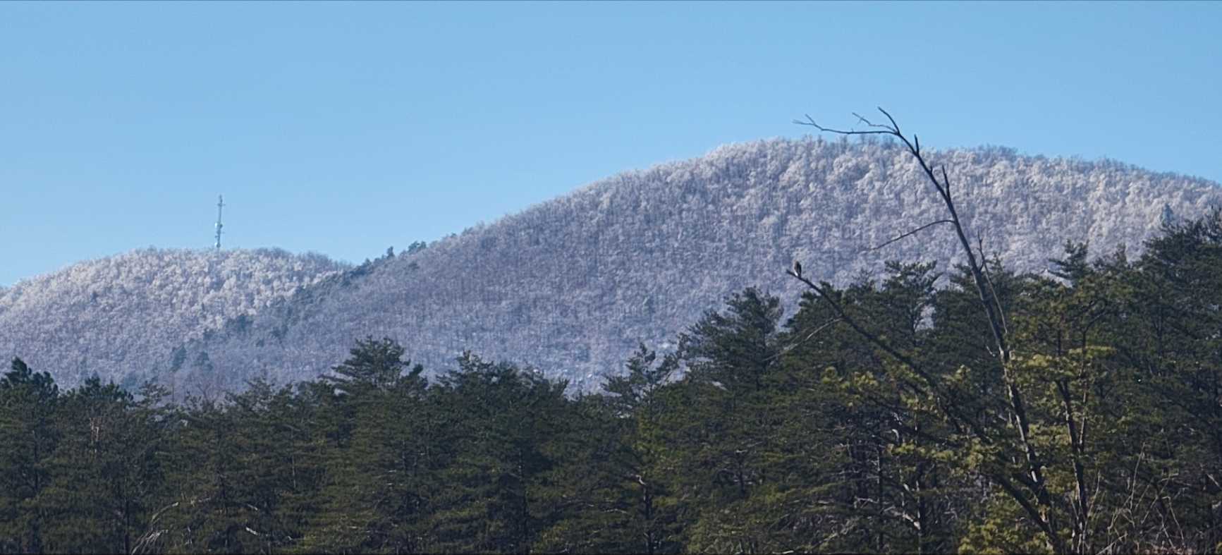
7 minutes ago, Bob Chill said:
Been surprisingly cold since the snow/ice. Trees are still holding ice in shaded areas today. Smith mtn is frosty up top. This is the east side around noon. Most of my pics lately have been west side. There's a nice sized hawk sitting on a branch enjoying the view looking for lunch.
WSW for 3-5" down here. Seems top end even with being closer to the juice but a 5" storm would be pretty damm awesome.

Wow...that's a beautiful scene and shot, Bob!! Love the transition from the blue sky, to the whiteish-gray snow/ice, to the green more in the foreground! And yeah, I see that hawk! Hope you score some good snow from this event.
-
1
-
-
2 hours ago, Ralph Wiggum said:
There's our big bowl look!
-
6
-
-
11 minutes ago, high risk said:
It's driven by lower-atmosphere temperatures. It's great at chopping amounts in marginal temperature environments, and the premise that SLRs will be better than 10:1 in cold environments has some truth, but it's not as simple as colder=better SLR, so it goes nuts when the air mass is cold.
Yup...that kind of reminds me of an event in Feb. 2015. It was extremely cold that whole month, there was an event around mid-month that everyone "assumed" would be high ratio fluff (so lots of excitement). But it wasn't. The growth rates and growth zone weren't ideal. We still got a solid amount to be sure, but it was more like thin ice crystals or pixie dust, not the huge flakes like we saw last night.
-
5 minutes ago, high risk said:
Thank you. The Kuchera drives me nuts. It always feels like this is 10:1
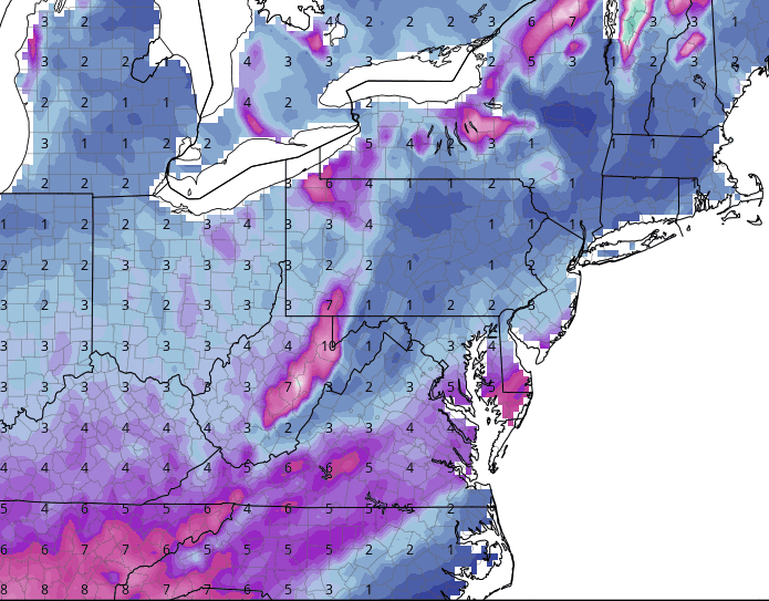
and this is the same case with Kuchera:

Actually, in all seriousness, I don't even know what method is used to compute the Kuchera ratios. Maybe it's good in some situations, but I've heard so many mixed things about it. Seems almost better to show 10:1 and go from there, fudge as needed.
-
1 minute ago, yoda said:
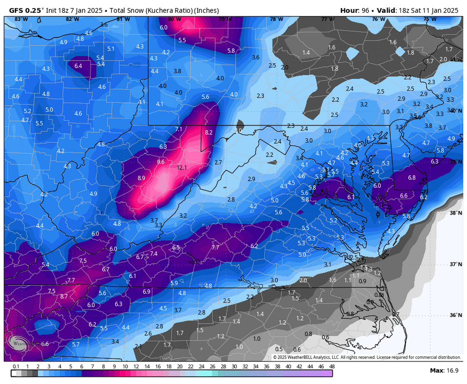
Can't hate that, really! Though I though the use of Kuchera ratios was perhaps not the best. Still, that is a nice advisory-level event in these parts (warning level in some others).
-
16 minutes ago, stormtracker said:
At the gym. Yinz on your own for the gfs. Good luck
Damn. Was hoping you'd be at the bar drinking complimentary tequila shots again, while doing the PBP!
-
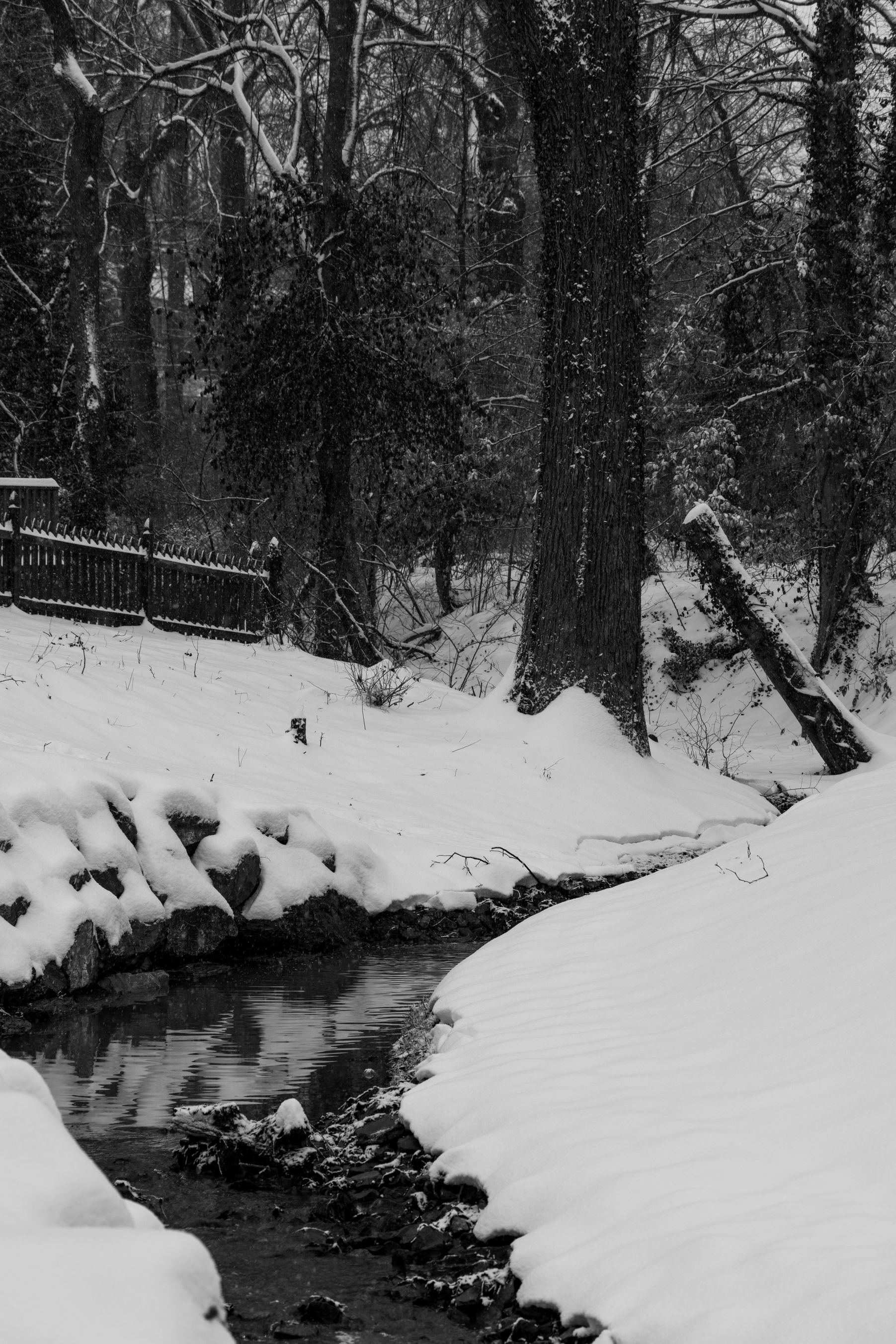
1 minute ago, diatae said:
Great pics! This one is my fav.
Thank you...so kind! I actually really like that one as well. As I said, black and white just works so well with snow scenes many times!
-
1
-
-
13 minutes ago, MillvilleWx said:
Man, the missing comma strikes again
Eats, shoots, and leaves...
Eats shoots, and leaves...
Eats shoots and leaves!
-
1
-
-
And...one more (file sizes required multiple posts)...

-
6
-
-
Photos (continued)...


-
2
-
-
Photos from today's snow (a couple are black and white...snow just facilitates itself to good B&W shots!)

-
4
-
-
Just now, Bob Chill said:
I'm not sure about this one. I do like my location this time. Overrunning precip zips north and I have room to spare in the mids/surface... for now... lol. Things are tricky as that slug comes up. I'd like to think I get a 2-4 deal before things fall apart if thats how it breaks. I prob won't get any extra effects from rapid deepening. That's likely well north of me. But I'm in an OK spot for a cohesive storm too.
Short story is its becoming likely another winter wx make is coming for both our yards. Impacts TBD. I think I stand a better chance for accum snow than you guys with a weaker/messier upper level system. You guys would smoke me with a bomb but that's what I'm rooting for no matter what.
18z gefs likes the more bomby idea but the gefs is a cult of the op at this range lol
Always good to hear from you, Bob! I hope the new digs are working out well...those photos you've sent over the past few months are amazing!
Agree...another winter weather event is likely going to affect us this upcoming weekend. Details, as you say, TBD (as always!). I feel reasonably confident or at least hopeful that a decent event for many of us is a good possibility. Doesn't even have to be a bomb, really.
-
Rippin' pretty good out here now, nice flakes. They may even be chunky (that's for you @diatae!!
). Just measured, now up to 6.5".
-
1
-
-
2 minutes ago, ravensrule said:
I would go with 12+ for the folks. 18+ is HOLY FOLKS.
So...Papal approval then!
-
3
-
-
Just now, Deck Pic said:
Who coined HECS. DT coined SECS and MECS, but HECS was someone else. I think
Actually I wonder that too. I know it stands for "Historic East Coast Snowstorm", but how is that defined? I guess something that would make the Kocin-Uccellini list, perhaps.


January Medium/Long Range: A snowy January ahead?
in Mid Atlantic
Posted