

Scarlet Pimpernel
-
Posts
7,346 -
Joined
-
Last visited
Content Type
Profiles
Blogs
Forums
American Weather
Media Demo
Store
Gallery
Posts posted by Scarlet Pimpernel
-
-
16 hours ago, losetoa6 said:
You guys are living the American dream man!!
But where's your beer ?

I'm currently sitting by the firepit drinking a double India pale ale baby!
Cheers!!
C'mon, must be holding a beer off camera! Bet @nw baltimore wx has a hidden selfie cam right there on the bottle...click and drink!

-
 2
2
-
-
11 minutes ago, WxWatcher007 said:
Not six feet under, but there's plenty space to rest in the ground. We’ve come a long way, now people wave and say hello when I retreat to my summer spot. Once again, adhering to social distancing with the exception of one.

Just remember to wear a mask when you go for your cemetery-side pickup!!

-
1
-
 1
1
-
-
4 hours ago, H2O said:
You post this pic and I'm the one that got yelled at for my weenies and Chef Boyardee spaghettios jello. This effing place.

C'mon! Don't even try to defend that abomination you posted! That's like equating jay-walking with running someone over!!

-
4 minutes ago, WxWatcher007 said:
Ok two things:
1. I’m on vacation. It’s the offseason for me. This is one essential business that is CLOSED. Winter weenies only.
2. Even the bony among us must adhere to social distancing guidelines. I’m doing my part!
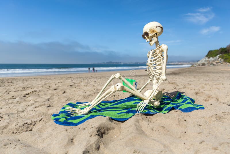
Don't forget the sunscreen. And where's the tropical drink??
(ETA: Do you make sure to stay 6 feet under??)

-
1
-
1
-
-
5 minutes ago, nw baltimore wx said:
Oh, definitely. Always add the olive juice.
eta: and shaken. It’s got to be foggy looking.
Amen! A filthy martini, plenty of olive juice!!
-
3 minutes ago, nw baltimore wx said:
I’m feeling like something salty. I’m going in for a vodka martini with olives.
Make it a dirty martini...add some olive juice as well!! Yummmm!
Oh, and don't forget, one should always eat the olives first. Don't want to drink on an empty stomach!
-
23 minutes ago, snowfan said:
Agreed. We're nearing the HHH months of summer when this place is mostly dead. The covid thread was mostly good and another reason to hit the boards.
Bring it back! Bring it back!
Maybe @WxWatcher007 should open up the Panic Room early this year. Would it be considered an "essential business"?? It sure is during the winter, I'm sure there's a loophole his well-paid bony lawyers will find to allow summertime reaping!
-
Just now, WxUSAF said:
Beer finished and it’s still going...
Time for another then! What a meeting!
-
46 minutes ago, DCTeacherman said:
Well there was @PhineasC, he makes some valid points but always throws in a hefty dash of the culture war stuff. “All the elite people enjoying the quarantine ordering door dash...” But then there was one guy who just posted worthless comparisons to the flu nonstop and another guy who posted some incoherent nonsense. At the end of the day the thread was fine. I say open it up!!!
Maybe we can open it up if comments remain 6 minutes apart. Temporal distancing, to better clean up useless posts. And to enter that thread, all users must come in with waders. Because it could get very deep in there, ya know!!
-
1
-
2
-
-
As I sip (chug?) my wine this evening, I'm reminded of that wise saying, "I'd rather have a bottle in front of me than a frontal lobotomy!" Truer words were never spoken!
-
4
-
1
-
-
6 minutes ago, WxWatcher007 said:

Oh, and please please please do not serve that in the Panic Room next winter!
-
1
-
-
-
Since the COVID thread is locked (ironically on lockdown?), I'll re-visit some controversy here. Never forget, never repeat!

-
1
-
3
-
-
Just now, RDM said:
Oh my, really? One would have thought the school districts would have raised this up the chain. With a coordinated response the technology exists to tactically establish hotspots and the associated linkages to major trunks quickly. The large providers and elements of the USG have those capabilities. Hopefully this will be part of the lessons learned that are documented and improved upon for the next time. (perhaps wishful thinking on the latter)
Didn't realize parts of BaltCo are not yet connected. The Dulles Corridor is singularly THE most connected data spot on Earth, yet our fellow citizens so close by have no Internet at all? Sad.
Fios finally came to where I'm living (suburban DC), at least finally in my apartment complex, about 2 years ago. What a huge difference that has made! I was using DSL right before that...seriously (yeah, I know!). Thank goodness we've got Fios now, with 3 people using the wireless with laptops (plus phones). It would have been really slooow if we still had to deal with DSL.
-
22 minutes ago, mappy said:
It’s bad up here man. So many locals on our neighborhood FB page about it. Comcast does not go all the way to the line. Many in the Freeland, White Hall and BaltCo portion of Manchester areas have no internet. Our local schools only just starting sending out hot spots and chromebooks last week.
Wow...I don't know how they plan to do something for those who don't have internet, or really slow internet. MoCo did a similar thing with chromebooks, if you didn't have access to a computer they'd loan one of those to you. For awhile, they supplied pickup for paper assignments or lessons as needed, not sure if they're still doing that. I know a few schools here also have the meal pickup.
-
-
2 minutes ago, ErinInTheSky said:
There's one friend that we will absolutely be in contact with, but all the rest, we haven't been super close to but he enjoys them at daycare.
Well, glad to hear he can at least stay in touch with the one friend!!
-
1
-
-
1 minute ago, WxUSAF said:
My daughter is a 6th grader and if her experience is typical (which I doubt since she’s pretty diligent and self motivated), then I think the distance learning is maybe 50-75% of in school education.
For my fourth grader, it’s probably 25% at best.
My daughter is a junior in HS this year, and she's pretty well motivated too. Agree that it's definitely less than 100% of what they'd normally get in regular classes. She's even said that herself. I might go more with your 75%, from what I can tell in what she's doing, but that's just a guesstimate on my part. While there's a decent amount they can do "virtually", you certainly cannot get everything. Including a lot of 1-on-1 if needed, or collaborative type projects. I imagine tests and grading are more lax too, just due to the nature of being remote. I'm still waiting on if or how the AP exams will be given this year (that's a nationwide thing though).
-
2 minutes ago, ErinInTheSky said:
I'm just really bummed my son might never be able to say bye to his daycare friends.

Any way your son might possibly be able to see any of them perhaps sometime during the summer, if things are OK to do that by then? Or if he'll see any of them next year?
-
Thanks for the update @mappy. I am not surprised that the rest of this school year will remain virtual. At this point, the previous date of May 15 would only be ~4 weeks before the end of the year anyhow and I guess they've been doing OK with the distance stuff for the most part. Not perfect, but it seems to work at least for older students (just going by my own experience). Also, I'm sure trying to pack every school in the state with a ton of students would be a bridge too far in terms of "gradually" opening things back up. Hopefully by fall, maybe students will be able to return. I know my daughter in a lot of ways just misses having others around, socializing, etc. with them.
-
1
-
-
47 minutes ago, H2O said:
Some people can't help themselves and others suffer because of it. Then we(mods) get labeled as playing favorites. Lots of victimhood up in there when its always on the poster to make better posts.
-
2
-
-
1 hour ago, losetoa6 said:
I see the political posts in the Covid thread were left up from last evening. Its a shame everything has to be political...even on a weather board.
Ever stop by the main discussion threads during the winter?
Snow becomes a proxy for politics!
Just kidding! Seriously though, you're right...some of the stuff in the COVID thread has gotten even worse than the ugly commentary when winter events fail!
-
1
-
-
3 minutes ago, stormtracker said:
Thanks man. I'm getting by. I'm essential, so my routine hasn't changed that much...been going in to the office..just odd seeing DC so quiet.
Good to hear! I'm doing fine, on mandatory telework which has worked out OK. I can imagine it's very odd seeing DC so quiet right downtown. Where I'm at, it's rather quiet as well. Kinda nice, actually. At least I've had a chance to get out with the camera and take many photos through all this...a sort of passion of mine. I still kind of owe you (and I'd like to do it anyhow) a photo either morning or evening when the sun is lower, of the marble bust of MLK at that memorial. I've walked by that in the past when the light was hitting it just right. I'm not actually sure if memorials and parks are open at this point...and I don't much care right now to Metro downtown. But, depending on how things go this summer, it's a goal of mine! I don't think the statue is going anywhere!
-
5 minutes ago, stormtracker said:
I'm almost to the point of just saying just open everything up. If we're all willing to bet human life to settle the issue, then let's just do it? I'm mostly being facetious, but at this point, nobody can agree on what the best path going forward is. I'm on the side of just waiting a bit and stagger things.
Also, I'm trying to figure out when all this became partisan? How does pro or anti lockdown means favoring one party over another. I dunno.

No idea how it all became political/partisan, really...oh well! But there is some good information in here to be sure, in spite of some of the sniping.
Good to see you Randy...I hope you are doing well these days, despite all this going on!

May Banter 2020
in Mid Atlantic
Posted
Gorgeous out today! Took a nice walk in the Audubon nature center near where I'm at. Much nicer than the cold wind yesterday.
Family up in Cleveland got snow on Friday! May freakin' eighth! Unreal. Enough to coat the grass a decent amount from what they said.