

Scarlet Pimpernel
-
Posts
7,815 -
Joined
-
Last visited
Content Type
Profiles
Blogs
Forums
American Weather
Media Demo
Store
Gallery
Posts posted by Scarlet Pimpernel
-
-
Regardless of how much snow anyone got, it was very pretty and quite peaceful. Here are a couple of photos I took today, all black-and-white (snow just somehow facilitates itself well to black/white!!)...


-
 13
13
-
-
24 minutes ago, Bob Chill said:
Now THAT is quality slant sticking my man!
The maximum! Parallel to the surface!

(ETA: ooops, originally wrote normal, instead of parallel, to the surface, LOL!)
-
2 minutes ago, WxUSAF said:
Not sure what you’re aiming for, but I definitely don’t hate it. Nice snow for DC and north tomorrow afternoon.
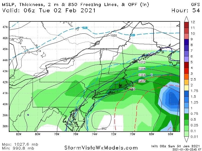
Yeah, was just looking a that. Whatever it's worth, it shows ~2" in DC, with maybe 2-4" just north of there (MoCo/HoCo, etc.), and more heading toward the M/D line. This is a 24-h amount from 00Z tonight through 00Z tomorrow night.

-
 1
1
-
-
Just now, WxWatcher007 said:
Yeah, we got em. Wasn't pretty.
It never is! But they gotta do what they gotta do, right?!
-
11 minutes ago, WxWatcher007 said:
Just did the first reaping of the storm. It actually breaks my heart. Solemn duty.
Seems your extra crew of hired guards was able to nab someone trying to jump early!
-
 1
1
-
-
Just now, Kmlwx said:
Funny random story....
When I switched schools in college - I managed to be home in Silver Spring during all three of the biggie storms in 2009-2010. My parent's still claim to this day that I planned my withdrawal process from my first college around the snowstorms
Hahaha...what timing on your part!!
-
Just now, Kmlwx said:
My parents and other adults always used to say "you're growing up so fast!" when I was a kid (I feel like all kids hear this...) and I never really understood or saw it. Now being 30 and seeing kids on my parent's street and some of my cousins kids shoot up like bamboo is insane.
Bob Chill's 6ft kids would tower over me (I'm 5'7") - WHAT IS HE FEEDING THEM?!
It's been a heck of a last year or so...lots of adjusting and "winging it" - hopefully some sense of normalcy will return later this year.
With how rough the past 12 months or so have been...and with how much last winter sucked...that's why I really am grumbling a bit more than usual at all the hand wringing. Fluffiest snow I've gotten in a while. If it shut off right now it would of course be a disappointment...but it's gorgeous out there. I won't try to force people to see things the Bob Chill/me way - but it sucks that so many people are all down in the dumps about snow.
Haha! @Bob Chill's kids would tower over me as well! My daughter is not even quite 5 feet tall and very slight (no real tall genes in our families, LOL!). Which is fine. She actually used to do ballet, for several years (Washington School of Ballet, associated with the Washington Ballet). But other obligations with school and other interests and such (plus an ankle injury at the time) kind of ended the ballet stuff a couple of years ago. She still got a hell of a lot out of it, and it was actually a lot of fun for her to participate in the company's Nutcracker a few times. A lot of work, but still fun!
Last 12 months have been quite rough for sure, for everyone. But I try to be optimistic about how things will go and that we'll get out of this at some point not too overly long from now. The snow today is certainly like a balm! Especially compared to last year. I enjoy photography, sort of a hobby of mine...it's been awhile since I could get some nice snow-related photos around here!
-
1
-
-
Eyeballing maybe ~1.5" there about where I'm at (Chevy Chase, MD area). Light snow falling, clinging to everything right now with the calm wind. Very pretty! I will be going for a @Jebman Jebwalk soon, and get some photos!!
By the way, nobody has mentioned much about the wind potential during this event, but looks like it could become pretty brisk?
-
4 minutes ago, Kmlwx said:
Tried to DM you. Clean out yer darn groupie mail!
Can't believe your youngsters are that old. I'll be 30 later this year and I still feel like a kid sometimes. My metabolism sure tells me I'm not 20 anymore...Haha, I hear that. My daughter turned 17 in November and is a senior in HS this year, and I cannot believe how fast that time has gone! I swear it doesn't seem like that long ago that she was out in a snow suit during the Dec. 2009 storm, with snow up past her waist level! Not such a little kid anymore, hahaha! It's just too bad that with COVID, school has been remote this entire year so far (actually going back to March last school year). I am certainly not complaining about the remote stuff, as I totally get it...but it's just too bad this happens during one's senior year is all. But you make the best of things!
-
2 minutes ago, BristowWx said:
Ha. You already buried me. This is a post from beyond. But thanks for the suite upgrade...the towels are soft and the mattress is firm!
Don't forget to collect your 20% off coupon for next year!! New promo from the Reaper, I believe.
-
2 minutes ago, AmericanWxFreak said:
Interesting...GFS actually doesn't look too bad for Mon-Mon evening just going by the 3 plots you put up here.
-
Just now, yoda said:
It still shows 4 feet for E PA
LOL, well there goes that idea! I also saw your QPF amounts listed a short while ago (didn't see before I entered my comment)...not a good change there.
-
Just now, psuhoffman said:
In fairness (dunno until the qpf comes out) I don’t think the rgem is bad it’s just the trend. Big step back from last 2 runs.
True...the trend is not a nice feeling. But being honest, the crazy, wacky amounts it was throwing out were not realistic. Perhaps it's converging to something more sensible? Well, that's the reasoning I'll cling to for now, haha! As you said, however, we should see the total precip (and snow) totals to get a better picture on the RGEM.
-
1 minute ago, Ravens94 said:

That's got to be the most bizarre looking closed contour around a low I've ever seen (992 off the coast)!!
-
I'm guessing this is how most of us felt about the 00Z NAM (inside, at least!)...
-
1
-
-
7 minutes ago, psuhoffman said:
Right or wrong (probably wrong) the NAM is chasing the convection and taking the secondary way too far OTS. It’s improving slightly each run with that but not enough. You can see the slp ride up the line of convection that fires out over the gulf steam vs tucking in along the coastal front baroclinic zone.
Not sure what you mean by improving slightly with each run? I thought the 12Z is when it first went crazy driving the dry slot much farther north than any other guidance, and seems even more so at 18Z. Not trying to be argumentative at all, but just curious what you meant. I'm interested too in the whole tracking the low along the convection rather than the coastal baroclinic zone.
-
 1
1
-
-
2 minutes ago, wxtrix said:
so i was the victim of a hit and run this evening. the guy behind me was mad because i slowed down at a RR crossing and was driving the speed limit (25 MPH) in town. he deliberately rammed me 3 times and when i pulled over, he drove around me and left.
i am totally unharmed. my car, naso much, but it's minor. my car is a tank so he did a lot of damage to the front of his truck. dumbass.
That's awful! Glad you are OK, but what an asshat that guy was for the hit and run. Not to mention getting upset because you slowed down at a railroad crossing and were *gasp!* going the speed limit. Glad the damage to your vehicle might not be too horrible too.
-
1
-
-
All we need now is @showmethesnow and the homecoming of the triumvirate will be complete!
-
Hello Ian...welcome back! Omegherd, shneer!!

-
1
-
 1
1
-
-
3 minutes ago, SnowLover22 said:
This must be a record or something right?

What the hell post was that one from??
ETA: The one where @Bob Chill returned yesterday afternoon?
-
2
-
-
2 minutes ago, CAPE said:
This is good stuff.

Ohhh, looks freakin' tasty!!
-
1
-
-
Just now, ers-wxman1 said:
Maybe they injected the vaccine into it leading to a healthy scenario.
As long as it wasn't bleach...

-
1
-
7
-
-
13 minutes ago, SnowenOutThere said:
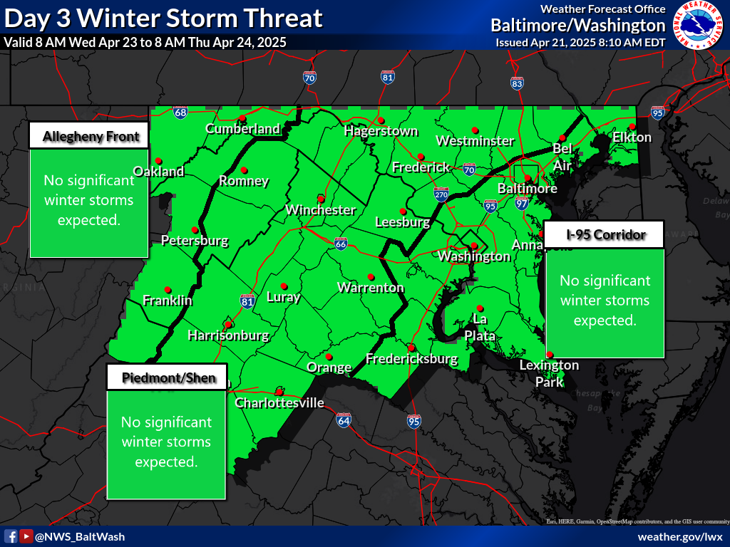 I still don't understand this map I think the potential impact or the confidence could be raised.
I don't think that's too bad for day 3...which is Monday into Tuesday right now. That covers what would be the coastal part of the storm. They have the 2nd level for potential impact, which is reasonable (it could certainly be impactful!). And the confidence is low...which sure, that makes sense right now, there's a lot of uncertainty for Monday-Tuesday at this point.
-
7 minutes ago, Bob Chill said:
That was a sleet bomb tho no? And very very rare honestly. But you're right, that was a coastal gone wrong in incredibly rare fashion. Personally, i love that storm for what it was. I mean our area was a legitimate glacier for days.
Yeah, I remember that Feb. 2007 storm and liked it as well. Admittedly, it was a bit disappointing because for some time it looked like a great widespread 12" or so snow event through the DC area. But even still, it was fun. I got ~3" sleet from that and maybe some glaze, and it did indeed turn into a block of ice for some time (it was very cold leading into that storm and then again after). I think areas just to the east of DC did get an appreciable ice storm from it.
I've said this before, but I also actually liked the winter of 2006-07, though many think it was "meh". We just missed the Feb. 2007 event being something huge, sure, and it was warm up through about the 3rd week or so of January. But dayum...February was a frozen tundra! I think we also got a decent mixed event later in January too, leading into that pattern. And Feb. 25 was like a 5-6" paste job. Feb. 2015 (and into early March) was remarkably similar in many ways with the frigid cold, but we maxed out our potential a lot better!


Jan 31st - 33rd Storm Obs and Disco like it's 1979
in Mid Atlantic
Posted
Right around 3" total to this point. As @WxUSAF said earlier, it's almost like sand! I posted a couple photos in the banter thread.