

MAG5035
-
Posts
5,718 -
Joined
-
Last visited
Content Type
Profiles
Blogs
Forums
American Weather
Media Demo
Store
Gallery
Posts posted by MAG5035
-
-
1 hour ago, Flatheadsickness said:
Or difference is over 2" for the last storm not .5 stop with the persuasion tactics . Any ways there was a few more lightning strikes today just south west of Altoona nicely oriented with yesterdays lightning.
- January 21, 2016bEE
I'd say the lightning strikes over that area today probably have more to do with the low level instability and terrain than anything else. We've had some pretty strong snow squalls today with the sun being out + initially warmer surface temps vs very cold air coming in aloft. That patch of strikes is on the crest of the Allegheny front, so likely some extra lift had a part in that. That other patch in western MD is on the same general ridgeline.
Here's the GOES loop with the lightning detection turned on
-
After taking a pretty close look at the afternoon models, there's still some pretty sizable differences thermally at the different levels. The 18z NAM manages to be the coldest and warmest at one point... having the sharpest surge of 850 temps of the bunch (+4ºC all the way to the NY state line in western PA) while simultaneously having the coldest 925mb temps overall (with -6 to -8ºC over C-PA). Safe to say, that's why the NAM has a lot of sleet. The Euro and GFS have a good bit less of a surge at 850mb while being a bit warmer at 925mb but still pretty cold while most of the precip is falling. Those models have been surging the 925mb level but after most precip has fallen. The 12z GFS was the coldest at 850mb and thus had the coldest overall column which was why it was flirting with a mostly snow event over a large portion of the area.
So there's all that...and I'll continue to note that this warm air intrusion aloft, whatever magnitude it is, will be brief. The maturing storm system in the lakes will already be wrapping cold around, and could in fact try to change some places back to snow as the 850 temps are already on the way back down late in the event. I think the central counties (esp I-80 north) stand the best chance of that scenario. Snowfall amounts are not only going to hinge on how solid the initial WAA snowfall is, and I think everyone should be good for at least a general T-2" from that... but also how well the column holds up when the main stuff arrives. If there isn't much of a break in between, I think most places could start the main wave of precip as snow as well. That's especially the case if the Euro and GFS are correct with less of an 850mb surge than the NAM's. Obviously from I-80 north this is predominantly frozen event to begin with and has the best chance of having several inches of snow/sleet. For the mixing I think sleet will be the dominant mix p-type. There probably will be some freezing rain to be had (Laurels, maybe southern tier) but this has a look of a more prolonged period of sleet vs it just being part of a transition to liquid/freezing. The cold 925mb temps in place are a big tipoff for me in that department.
-
 1
1
-
-
5 hours ago, Itstrainingtime said:
8.7" season total for me to this point. Surprised that HBG is that far behind me.
You still got me lol, 0.2" this afternoon here brings my total to 5.3" on the season. I'm essentially at 10% in terms of average snowfall for the winter.
-
4 hours ago, Voyager said:
Did anyone else notice a huge difference between the 10:1 snowfall map at 84 hours between Pivotal Weather and Tropical Tidbits with the 12z NAM? Pivotal is showing next to nothing up the Susquehanna and about 4 inches in my backyard while TT is showing 6-8 regionwide...
Tropical Tidbit's lumps sleet/ice into their 10:1 snowmap, which the NAM has a fair amount of. That's why you see really blown up snowmaps on that site in areas where p-type is potentially an issue... which btw I feel like every single significant winter event dating back to the beginning of last winter has had p-type issues.
To add to that, the ICON p-type maps on TT is flawed a bit as well. There's only a conditional for snow and rain, not ice... so you won't see where there's mixing present on that one via the p-type map.
-
Well today's 12z GFS was probably one of the better runs yet for the area from that model, essentially having a nearly all snow/frozen event for everyone north of the turnpike. The Euro doesn't have a lot of QPF up front, or overall really... probably about 50% of the GFS QPF. I don't see a tremendous difference thermally, 850's spike above zero very briefly and they're already crashing all within a 6 hr frame on both. The Euro just didn't have very much of a front end thump, whether that's right or wrong. My opinion attm is it probably is a bit too dry. Anyone with Euro ensemble products can probably see if that's reflective of such things on there. Still plenty of time, by this time tomorrow we'll be able to get some early hot takes on the NAM.
This probably won't be an especially long duration storm either, pattern is still progressive. This thing is coming into the Pac NW, reforming on the other side of the Rockies and pretty much moving straight across at the same latitude. The strong high is there but it isn't anchored and will be moved as the storm approaches from the west. But cold air wraps around this system quickly and never really drives up anything torch-worthy aloft, so I think the cold will hold at low levels enough if the heavier precip is there up front. I'd say the top end potential is a 4-8 type deal for a C-PA location that sees a mainly frozen event.
-
3
-
-
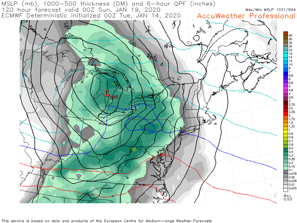
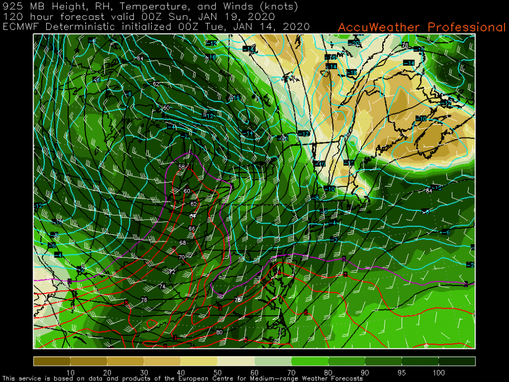
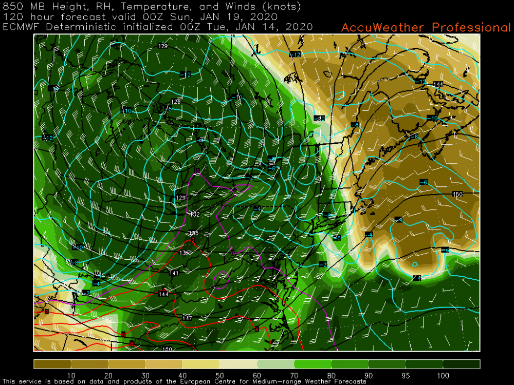
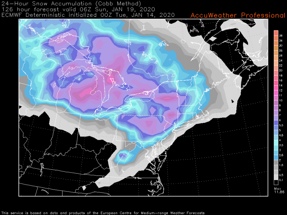
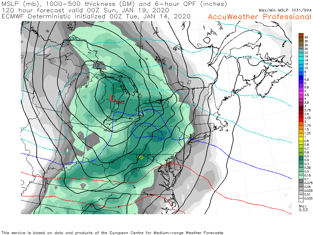
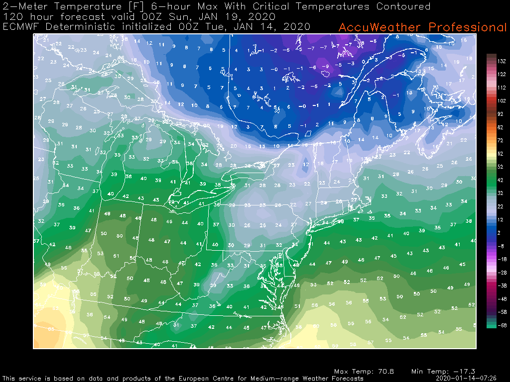
The money frame on the 0z Euro as it regards to 6 hr QPF (hr 120) in order of surface, 6 hr max 2m temp, 925mb, and 850mb levels. Also added 24hr snowfall ending at hr 126 using the Cobb method. Still at a pretty long range yet but just showing how I start breaking these complicated snow-mix setups down in the shorter term. The <0ºC 925mb temps are pretty well anchored and the 850mb level holds out fairly well despite a pretty strong SW flow aloft. The hr 126 frame shows the brief warmth surge at all levels but that's after most of the precip has exited. 2m temps reach the low-mid 30s region wide according to the 0z Euro. Also note the surface, 925, and 850 lows are stacked (near the same position) indicating a maturing storm and the occlusion I've been mentioning that will likely keep the warm surge brief and muted.
As for snowfall the Euro overall seems to remain a bit north/northeast with it's heavy snow axis vs the GFS and esp Canadian, or at least a bit limited in the southern tier in the central counties, likely implying the Euro is indicating some kind of a mix (likely sleet) possibly knocking the totals down a bit. At any rate, a lot to unpack the next few days. Another thing to consider is if models continue to show the high at the 1045ish strength they've been showing, this may trend a bit colder yet as this gets into the short range model's range.

-
2
-
-
3 minutes ago, Blizzard of 93 said:
It sure was a very nice 0z GFS run !
Here is a panel that @Itstrainingtime , @pasnownut & @daxx would also approve, along with the 10:1 & Kuchera ratio snow maps.
The strong high pressure being progged certainly bodes well for significant front end snows in the Sus Valley... reaching 1045mb as it moves through southern Ontario into southern Quebec. Even through the high eventually retreats as the storm presses through the lakes, that's going to be tough to displace low level cold east of the Laurel's.
-
5 hours ago, Atomixwx said:
Guys. I'm a graphic designer. That graphic is stupid and hard to understand.
Remember the graphics they put out for an Alberta clipper the one time (awhile ago) that were straight out of the Microsoft Office clip-art section?
-
2 hours ago, Voyager said:
I may not always be the happiest person when I see that you posted, because it usually means some sort of wintry weather is on the way...
 , but you, sir, are a treasure to this sub-forum with your knowledge and willingness to share it. I think I speak for all when I say, thanks Mike, we are glad you are here!
Thank you for the kind words, I really appreciate it. I wish we still had some other met presence in here. I know a couple of our other regulars have moved to other places.
-
The overall big picture features and their positioning for our end of the week system remain pretty firm today on the models... strong high placed to the north and a significant system tracking to the Lower Lakes with a decent chance at a nice front end snowfall for most of the area as well as a to be determined period of mixing. 12z GFS and CMC were the snowier models today with the Euro solution focusing its significant snowfall (6+) from I-80 north. As CTP mentioned in their disco this afternoon, those details will start really getting hashed out once the high res short range models are in range and in the fold with determining a consensus... so I wouldn't get too bent out of shape on run to run or model vs model differences.
Given the pattern and a really good consensus track-wise on the models at what's still a pretty good lead time, I don't anticipate much deviation in the eventual track of this system into the Lakes. The strong high to the north will be a key for the front end snowfall and I believe the timing of the occlusion of the storm system along with how well the CAD holds will determine if the rest of the event is mostly on the frozen/freezing side. A track into the eastern lakes already implies our region we'll likely get slotted anyways late in the system after whatever damage is done. It does look at the moment that any warm surge into the area will be relatively brief. I mentioned some shades of last year's Jan 19th storm with this potential storm in my post this morning. This one as is right now would be a bit more NW (last year tracked into PA) but I believe would have a stronger high in place if I recall correctly.
-
2
-
-
The 0z suite looked pretty good overnight, with a significant front end snowfall on both the GFS and Euro aided by the progged strong high pressure. The preceding shortwave mid-week is more notable on tonight's guidance which may be helping set the cold air boundary better. Euro solution was the snowiest, with a majority of the subforum seeing 6"+ on 10:1 maps. GFS had 6"+ north of the turnpike central and eastern thirds of the state but turned most of the area over to rain at the end. That usually doesn't happen as either the storm overall ends up warmer and you see less front end snow or you get significant snows up front and typically that's a colder/icier outcome after changeover. Euro solution presented an opportunity for potentially an all frozen event or snow to mix for some as it is a tad weaker with the primary and it looks to occlude/ try to transfer to the coast. Gonna be interesting to watch this evolve this week. Some shades of last winter's Jan 19-20th event.
-
1
-
-
Normally I'd say a 1040+ high is money for a mostly frozen or icy event in most of C-PA, but these are pretty wound up solutions into the Lower Lakes along with the high pressure not being anchored. We need to see a weaker low or a better/early enough transfer to the coast. Obviously a further southeast track underneath us would be ideal but this one probably cuts if it ends up being a deeper system. Certainly a solid possibility of seeing decent wintry weather impacts but this will def be a flawed system/setup. We're in the midst of the transition period in that timeframe and we're not quite there yet pattern wise as still see pretty notable eastern ridging present at 500mb with this storm arriving.
So the big keys will be strength and positioning of the Canadian high for the system arriving, and how much the cold presses into the area later this week prior to the event. If you don't press that boundary far enough south we could end up with an event that's more wet than wintry.
-
1
-
-
Def a strong signal for the event around the 19th-20th, as it's been pretty prominent on the models the last few days. Quite a strong high to the north being progged, which is a change from most of the events we've been presented with so far this winter and if that feature remains a player on ensuing runs we will likely be tracking a winter storm with potentially wide ranging impacts for our area this week as we bring in some fresh cold just prior and set in place that high pressure.
The pattern going forward for the second half of the month is rapidly looking much, much better. We're currently working a very high amplitude phase 4/5 MJO but I've noticed in forecasts the last several days that this MJO pulse has been progressing rapidly out of the bad range (4-6) and it is starting to carry amplitude into more favorable phases on some of the model forecasts. We could find eventually that this ends up carrying into 8-1-2, which could potentially help the NAO realm if that were to come to fruition. We see lessening of the +AO over the pole and a stunning reversal of the PNA (which our next potential winter storm is right in the middle of) in the forecasts as well.
Considering this winter as a whole so far, we're really right around where we were at this time last winter minus the November snowstorm.. complete with cancelling January during the last week of December and all.
32 minutes ago, Jns2183 said:
. ProIntriguing that the fabled decade that the ice age was coming back (the 1970s) has only one less 68º+ meteorological winter day than this past decade.
-
 1
1
-
-
6z NAM for the win this morning haha. I mentioned first thing this morning that the NAM with the Cobb method had a stripe of 6”+ running the far southern tier... indicating better than 10:1 ratios as that method incorporates ratios in the snow growth zones in the column. 700mb forcing was likely pretty good and we had a cold column. The rates were enough to overcome initially marginal surface temps and realize most of the accum potential via ratios. I’d be curious what those 4-6” amounts melt down to.
-
1
-
-
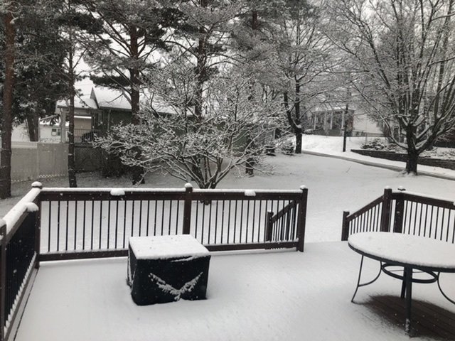
2.0" was the final here.. I'm glad things came back up enough to see something half decent. Next up is the potential for snow squalls in the central counties tomorrow.
-
1.7” with moderate to heavy rates. Pretty wet snow with roads slushy or snow covered.
-
1
-
-
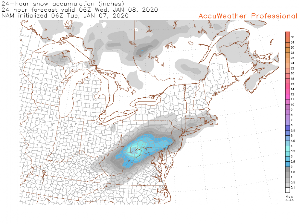
Overnight models have bumped back north with precip, getting a good majority of the subforum into snow today.. even up to IPT. Here's one of the 6z NAM snowmaps. It may be one of those positive snow depth algorithms. The Cobb method, which I believe is the one that incorporates the actual snow growth region with it's ratio calculation has a stripe of 6"+ running the mason-dixon line. That's an indication that aloft, the column is cold enough to support better than 10:1. The ground truth will probably be tempered a bit though with initially marginal surface temps. A quick snowfall but if we get some fairly robust rates I wouldn't be surprised to see 3 or 4 inches in spots along the southern tier. Here's to some + snow before the mess and warm weather at the end of the week.
-
2
-
-
6 minutes ago, pasnownut said:
Wow, it really has been late to the party on this one, but verbatim is trying to bud in line to steal the dance w/ the class cutie...
It is a typical bias of the GFS to lose then find the storm, so this isn't something new....even though the model is :). If one toggles through the 500's you can see it tucking in a little tighter to the coast and parsing over the ICON and NAM, they all have a somewhat similar evolution and consensus on this event. I'll gladly take it. Even if it is gone in a few days.
Funny thing is there is enough time for another subtle shift or 2 (good or bad)
I'll get on the GFS and HuRRR train, as that model's been pretty well north with the precip as well since we've gotten into HRRR range. Otherwise this system's getting just close enough for me to see someone like Cashtown probably double up my 3" on season totals to date.
-
7 hours ago, Bubbler86 said:
As you have probably seen me mention I stay away from some of the more technical meteorological definitions because I do not always understand them well enough to comment and I think there is too much weight placed in trying to define patterns into each category however what I saw on the 12Z GFS (did not look at 18Z) was a trough that was threatening to go negatively tilted with LP's near by in both the Northern and Southern Stream (and an HP just departing to our North East). It did not work out on those panels but to me it was the closest thing to a SEC/MECs I have seen so far this winter. In fact there was more that one opportunity on that 12Z GFS with other chances of boundary snow.
The cutter parade has been a nightmare for at least two winters in a row now.
When it comes to the teleconnections, tropical forcing (MJO), etc there is certainly an argument to be had with placing too much weight on them at times...specifically when you have conflicting signals or magnitudes that aren't very strong. You will often hear me say that we don't need a -NAO to get a snowstorm around here. What we have with this pattern however, is strong magnitudes and correlation between all the different teleconnections in favor of the unfortunate result for our weather... That being southeast ridging and us being on the wrong side of the boundary for this upcoming period coming up. Honestly I think we're closer to this pattern eventually breaking into something way more favorable for us then one might think, but we have to ease the magnitude of some of the teleconnections working against us.
I'm not sure which event you were describing on the GFS. If your talking about Tuesday's system, it's close to being something bigger but the pattern is too progressive and we see little interaction between the northern and southern stream. The result is the southern stream wave kicking out flat and unless models come back north some we'll see the bulk of precip going to MD/VA/DC and skirting the southern tier of our region. And it's an event on the lighter side to begin with anyways. We were closer to a MECS at the beginning of December when northern and NE PA on up into the interior northeast got whacked by a significant snowstorm and actually did give places in the LSV some snow.
Now tonight's model runs were interesting in the day 5-7 range. The GFS for instance has a cutter but also has strong Canadian high in place to the north and a much more moisture laden storm system. Like I said yesterday, there is a lot of cold air on our side of the pole... and between that and the SE ridge there is liable to be a huge temp gradient. The result will likely be a swath of significant snow and especially ice somewhere with the high pressure over the top in Canada. Both the GFS and Euro tonight illustrated this although to far northwest for us. This might actually have to be watched because a well timed strong high pressure moving to the north along with an approaching system from the south is the way to score winter weather in this unfavorable pattern. But it would have to be timed perfectly with the progressive pattern. The more likely result is another rainstorm with the wintry weather not far off, again.
-
12 minutes ago, Blizzard of 93 said:
Yes, one run we are in the bullseye & the next we are not. The storm doesn’t even form until tomorrow, so there is lots of time to resolve. The Euro & Canadian have been fairly consistent with putting CTP in a good spot for this event over the last few days. I’m anxious to see what they have to say at 12z today.
The NAM for most runs since this thing has gotten into it's range has had it south of the area. 12z Canadian still runs a decent swath across the state while the GFS skirts the area but doesn't have much QPF. I am kind of leery of this late blooming system in this progressive pattern as precip is only starting to blossom in KY/TN. If we get decent precip rates I think we'd have accumulating snows but surface temps are going to be marginal so if rates are light, I think lower elevations in the LSV are going to have issues. This is looking like a quick 4-8 hour and 1-3" type deal if we get it. I had been thinking it had the potential to be a somewhat more potent system with higher end advisory amounts on the table but this has trended towards the progressive end overall the last several days.
29 minutes ago, Bubbler86 said:I definitely like the mid January potential the GFS has shown the last few runs. Pattern wise it is close to something interesting.
The frustrating part about this pattern, or at least one of them.. is the fact that we are certainly not lacking cold air on our side of the northern hemisphere. Canada looks downright cold and that dumps more into the west with the pattern alignment. The PNA on the ESRL site is forecast to dip to -6, which I don't know if I've ever seen that magnitude forecasted for that index. That's the downstream response of course to the massive central Pac ridge being progged to dominate that realm (western US trough). You couple that with a +NAO on the Atlantic side and a very positive AO and that's a bit much for even our latitude to be on the right side of the boundary for storm systems. And you see the results of that in the form of the cutter parades we're seeing on the longer range of the models. It's a tough look for at least the next 10 days.
-
This happened in the western part of the state early this morning (Westmoreland County). Jesus.
Turnpike closed from Breezewood to New Stanton
https://www.wtae.com/article/multiple-people-dead-after-crash-on-the-turnpike/30400744
-
Some late night snow squall action has arrived with some pretty solid wind gusts. The streets are even caving.
-
1
-
-
Count the 18z Euro as south of the region as well, some light precip near the MD border in the LSV but main precip south. Biggest model run of our lives coming up at 0z lol.
-
18z guidance is coming in low so far. GFS and NAM slide the Tues system south of the area with pretty much no precip into our region on the GFS and a bit into the LSV on the NAM. NAM is colder and has a solid snow event in the DC/Northern MD/NOVA region and a bit of snowfall into the LSV but not a lot. That would figure lol. DC would have more snowfall on the season than me if that came to fruition. Anyways will have to see if this more progressive turn holds water in ensuing model runs.
Also, I was laughing about @canderson still pulling weeds a few days ago and find today that my magnolia tree in the yard has a bunch of buds on it haha.
-
2
-
 1
1
-


Central PA - Late Dec 2019/Jan 2020
in Upstate New York/Pennsylvania
Posted
I dunno why snow amounts from the previous event (that unfortunately has long since melted away even) are a thing tonight but according to the snow totals into CTP, they ranged from 2.0" in Mechanicsburg to 7.0" in Boiling Springs in Cumberland County and excluding a couple early reports.. 2.9" at the Airport in H-burg to 5.5" in Hummelstown and near Elizabethtown with other H-burg suburbs in the 4-5" range in Dauphin County. I wouldn't consider a 4.0" near center city Harrisburg as being a suspiciously low-ball number. Most of the 5-7" amounts ran on a line just south of the city.
https://forecast.weather.gov/product.php?site=NWS&issuedby=CTP&product=PNS&format=CI&version=5&glossary=0