

MAG5035
-
Posts
5,718 -
Joined
-
Last visited
Content Type
Profiles
Blogs
Forums
American Weather
Media Demo
Store
Gallery
Posts posted by MAG5035
-
-
4 minutes ago, Cashtown_Coop said:
looks like a heavy band is aiming ur way. Get some
Yup just starting to move over. Pretty heavy with visibility about 1/4mi. Driveway and back street thinking about caving, haha.
-
Progress, we're white on non paved surfaces now. Moderate snow.
-
1 hour ago, pawatch said:
Mag what's your thoughts on ratio's?
Ratios probably aren't going to be great in the opening couple hours of this storm but they'll progressively get better as we cool surface temps. Aloft at 850 and 700mb are plenty cold over all of C-PA for good ratios, we just need to get the near surface cooled off and the sun down. Per mesoanalysis everyone in PA is at least -5ºC at 850mb and as low as -10ºC along the NY border. 700mb ranges from -6ºC SE PA to -12ºC in north central. When we start increasing the forcing especially at 700mb we should see pretty good ratios. You and Wmsptwx might make up a lot of the gap in accumulations by having better ratios.
Part of CTP's disco:
QuoteEnsemble mean qpf, combined with snow/water ratios ranging from around 12/1 over southeast Pa to 18/1 over the northwest counties, supports storm totals ranging from around 2 inches over Warren/Mckean counties, to between 6-8 inches south of I-81. An examination of model soundings still indicates the possibility of the rain/snow line grazing extreme southern Lancaster County this evening. However, for the vast majority of the forecast area, this will be an all snow event.
-
 1
1
-
-
Settled into a pretty decent light to moderate steady snow in the last hour or so. Nothing to report accumulation wise yet though on the non-snow surfaces.
-
Light snow has started here.
-
I put up a post first thing this morning pertaining to my thoughts on the LSV with maybe being a bit warm to start off. I’m not particularly worried. Even if there are issues on the get go, things should quickly turn to all snow and once we get past 3-4pm any surfaces benefitting from the March solar radiation will “cave” when the steadier stuff arrives.
-
 1
1
-
-
The long 6z HRRR looks pretty good for everyone in terms of precip shield and strength but it's been pretty insistent on a rain p-type to open up the first few hours of the storm in the Sus Valley. Otherwise, accums would be pretty robust across our whole subforum as depicted by that model. Def at least a 4-6" type snowfall for most if the rain conditional wasn't affecting numbers on the front end in the Sus Valley. Would it actually rain at the start? I don't think.. but the reason the model is likely showing such things is because the skin surface temps are above freezing and I'm sure intensity the first few hours isn't high.
Timing for the start seems to be the mid afternoon in the Sus Valley (1-2pm) so these above freezing surface temps could materialize at the start. Something to keep an eye on but I think everyone starts as snow (and stays snow the whole storm) and solar insolation would tail off quickly after about 3-4pm if lighter rates weren't doing much on the ground at the start. If this were a late March storm I'd be more concerned about solar issues eating light snowfall but we're at the beginning of the month.
-
1
-
-
I’m hoping for 6”, that would give me a 6+ in every month except December. Don’t think I’m gonna get it with this one though.
-
1
-
-
This was the 18z NAM's snowfall using the Cobb method. That one incorporates BUFKIT data into calculating it's snow numbers.
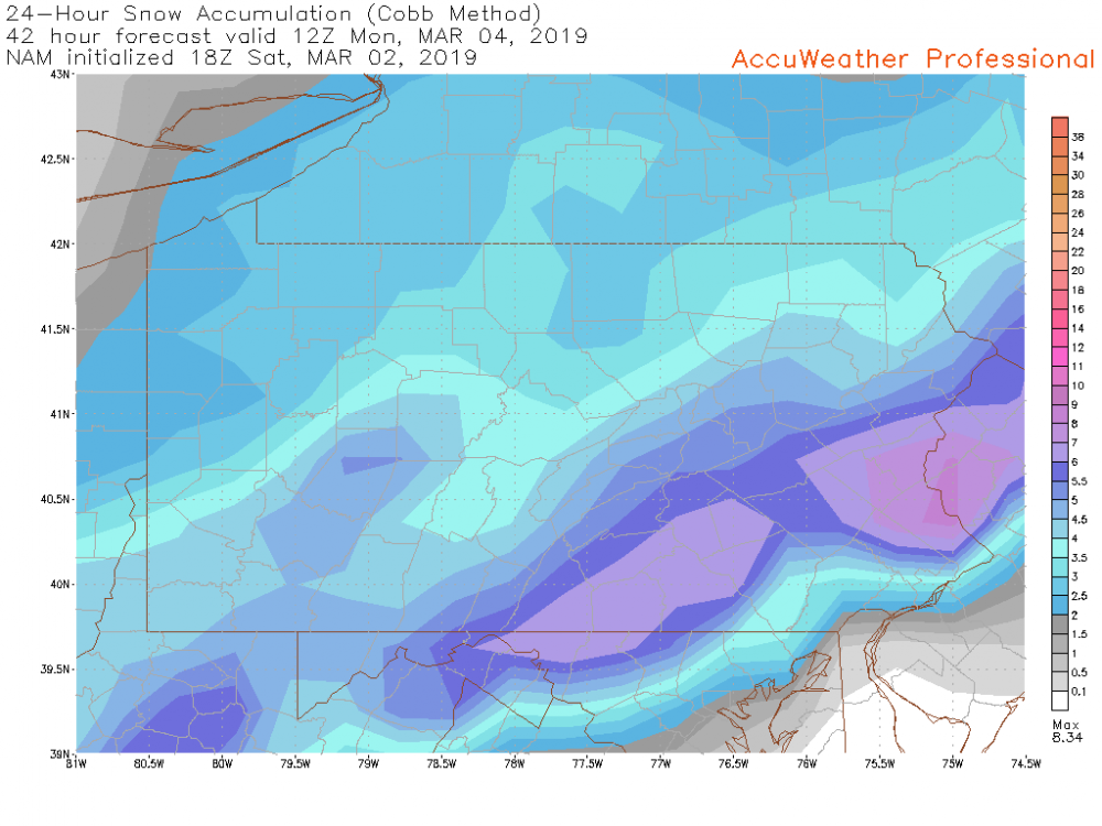
I'd be surprised if CTP went to warnings on the section of counties from here to Lewistown to SEG. I'm just not seeing enough support for 6", which is the criteria in these counties. I mean it wouldn't take much, especially if ratios were to play into it.. but this is looking like a 3-5" ordeal for JST-AOO-UNV-SEG. Temps aloft look to be sufficiently cold for good ratios in that region, but need the forcing to capitalize.
Again, I think progression is a bigger issue than track. Most modeling including the GFS does get just about the whole state into the snow shield so I don't think anyone in PIT or in here gets shut out or less than 2-3" but we've really narrowed the corridor of 6"+. I rode the hot hand of the Euro/NAM combo in the 48-60hr range and it finally let me down. We may shift back north a tad in the couple runs before game time but I don't think that widens the 6+ corridor. I've already noted previously even with the more amped stuff we saw that I thought this was a 5-10" snowstorm because of the progressive nature of the system. That ceiling might be more like 7 or 8" with the weaker solutions that the more amped models have headed towards in addition to the narrower corridor.
CTP's afternoon thoughts:
Quote.SHORT TERM /6 AM SUNDAY MORNING THROUGH MONDAY NIGHT/... 3 pm update... The main system of interest continues to be the southern stream low slated to impact central PA Sunday and Sunday night. Recent model/ensemble trends continue to nudge the storm track southward, while also keeping its forward progression fairly rapid. Correspondingly, earlier projected snowfall amounts have dropped a bit. Given the synoptic back- drop of a broad eastern CONUS trough, with a fast flow undercutting the eastern Canadian vortex, along with a lack of north Atlantic blocking, the latest model trends may sense. Given above reasoning, we`ve converted a stripe of counties along and just north of I-80 to a Winter Weather Advisory (generally 2-4" anticipated). Farther south, given the amount of uncertainty still present, we`ll keep the Winter Storm Watch in tact. A solid 4-6" of snow is still plausible for south-central PA, with locally higher totals not out of the question. Overall, though, rapid system motion and comparatively less impressive frontal scale forcing (as compared to some previous storms this season) should prevent this from being a "blockbuster" snowstorm.
-
1
-
-
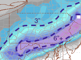
Yea, the 0z Euro is more progressive and much weaker. The low is SE some but the bigger thing is just how much weaker the system is. It doesn't have the expanse of decent precip to the NW that got our western and northern folks good snows. The result is a narrow area of 6"+ with about an 8" max in PA.
24hr Kuchera
-
1
-
-
Well, CTP reissued all their watches around 1:15am including the north central so they would've had a look at 0z including Euro. I'm sure they're going to keep continuity for another set or two of runs to see if this decided shift holds up. I'll have my full Euro to look at in about 10min, but just looking at the snowmap above suggests to me progression is more of a problem than track (although the axis is def SE). We were talking a broad area of 8-12" last night at 0z in central PA. Now we don't see 6+ show up til a much more narrow stripe from northern MD, through Lancaster/York and then working just NW of Philly.
-
10 minutes ago, canderson said:
Picked up nicely in the last 30 minutes - been all snow. A bit light right now but the heavier returns to the SW should get here within 45 minutes, Might stay up for the Euro.
Edit: nm no way I can stay up another hour and half
Just wait til DST starts next weekend if we have anything to track at that point haha.
-
Precip trying to get up to here but looks like i'll be sitting this one out tonight for the most part.
-
Knit-picking the GFS track on the 0z run would actually have the low hitting the coast a bit north. In the VA Beach/off the southern tip of the Delmarva realm vs 18z whichwas at the VA/NC line to near the northernmost OBX. That track's pretty good really. NAM came southeast some at 0z but models overall seem to be tightening the precipshield, or at least the portion that delivers more significant snows. GFS still seems the southeastern most moving from there to the benchmark, keeping most of SNE snow.
To answer the question of why this might be pressing south or just not coming north a lot is because we have a very cold pattern pressing even without a high directly to the north. There is a monster high dropping into the upper plains with a ton of cold air. Temps are plenty cold aloft for this storm over most of PA. Was looking at the Nam and it had the -8ºC 850mb line running roughly through the middle of PA and -10ºC up in northern PA. That's pretty cold, it's good from a ratio standpoint but it shows the tight thermal gradient is along the mason dixon line. Tonight's departing coastal seems to reinforce the cold aloft later tomorrow which resets the boundary a bit further south than it might have been. We gotta get the storm all the way onshore tomorrow in the west and the coastal out of the way til I think we see the final adjustments on things. I think the fact our Sunday storm isn't even all the way onshore yet in the west coast on Friday night should tell you how progressive the pattern is.
-
1
-
-
Geez is anyone in the Sus Valley seeing snow?
-
18z NAM's right on the Delmarva with Sun/Mon's storm like the Euro.
-
1
-
-
1 hour ago, Wmsptwx said:
That coastal is why I have no expectations above couple inches or so.
1 hour ago, KPITSnow said:I think you and I are in the same boat on this one.
I don't think it's going to affect Sunday's storm to the point of a fringe job in the west and north. I mean maybe NW PA sees more of an advisory type event but I just think that it affects it enough to take the low running close to/ into PA scenario off the table. Most guidance is taking a TN Valley low inside to or near the Delmarva, so the flat trajectory would bode quite well for all of western and central PA. The GFS brought the low to the coast near the NC/VA border, which is still a workable track but a track like that would divide the subforums into the northern parts seeing okay snow and a stripe of the southern parts seeing the heavy snow axis. I think the Euro looked like it was the most NW attm with the 12z suite, taking the low over the Delmarva peninsula. Pretty much everyone in PA outside of the Philly region in SE PA and Erie had 6"+ on the Euro Kuchera map (24hr map that doesn't include tonight).
-
1
-
1
-
-
This series of events has certainly been very poorly forecasted in the short and intermediate range. People say about the NAM being the NAM after like 24 hours but that was the only model that had last night's event in western and central PA outside of maybe the extreme southern tier prior to Wednesday. Now we have a half decent developing VA Beach/Delmarva low tonight before the Sun/Mon Delmarva low that has actually been forecasted.
My worry about the main storm Sunday has been it creeping too far north, bringing more widespread issues turnpike and south or at the worse case.. I-80 and south. I think this.. bonus coastal probably takes that off the table. The only areas of concern I really have at the moment are the mixing zone which likely will reside near the M/D line and perhaps creep into York and Lancaster, and up north of I-80 having lighter snows in case the GFS is actually right for a change with it's more SE solution. Like I said yesterday, still think this storm is a faster hitting 5-10" type event for the heavy snow axis. There's no high to the north to A. help slow it down and B. Enhance anomalous easterly fetch. That would've probably turned it into a much more significant, say 12-18" type big hitter. Either way, it's going to be a good snowstorm where the best QPF sets up.
-
1
-
-
Measured 2.8" with some lingering light snow continuing.
-
25ºF with Moderate snow and 2.5". Def a >10:1 type snowfall fluff-wise.
-
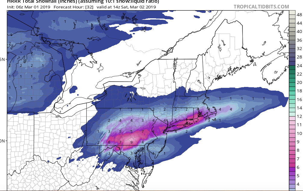
6z long HRRR with a glance at Friday Night's shot. That's another advisory type event for at least the same places under the current advisory and probably add some counties if that were to come to fruition. All of LSV and most of the south central at 6"+ between the two events. Developing low in a good spot for us.
-
1
-
-
42 minutes ago, Blizzard of 93 said:
The 0z Euro was a fantastic run for most of CTP with 3 snow events through Monday.
It still gives all of southern PA 2-4 inches tonight.
Then, it is juicing up the event tomorrow night into Saturday am, adding another 1-2 inches for most of us.
The Sunday storm absolutely crushes the I -81 corridor of PA. It does bring in some mixing at the height of the storm to York & Lancaster.
Here are the 3 Euro maps as the snow accumulates for all 3 events. The last map is the final total when all 3 events are done on Monday !
The 24 hour Kuchera snow map covering just the Sun Night-Mon storm had 6+ for pretty much the whole subforum save for maybe the extreme southern edge of Lancaster. JST/AOO/UNV/FIG/IPT/MDT/THV/probably LNS within an 8-12" zone. IPT and FIG riding the 8" line. It's a big hit for the subforum. Pittsburgh/SW PA 6-8" range.
-
Almost at the 1" mark. Moderate to heavy, caved roads, the usual.
-
Snow has started here. Time to freshen the glacier up, the windstorm blew a lot of pine needles and other junk on it haha. Base snowpack running roughly about 4-5". The 2/12 portion of the pack under the top 2" is back to being bulletproof again.


Central PA Feb/March 2019 Disco: More Snow In Our Future?
in Upstate New York/Pennsylvania
Posted
Also @Cashtown_Coop, I can't believe your going to make a run at 50" for the season with this storm all the way down there. I'm only about 4" ahead of you.