

MAG5035
-
Posts
5,718 -
Joined
-
Last visited
Content Type
Profiles
Blogs
Forums
American Weather
Media Demo
Store
Gallery
Posts posted by MAG5035
-
-
Steady light-moderate snow. Temp 28ºF
-
4 minutes ago, Itstrainingtime said:
Do you know of a good radar that eliminates virga, or does such a thing exist?
There's not really a radar that will eliminate virga. Radar apps like RadarScope that incorporate ground observation data from apps like mPing can really help with ground truth, although that depends on people to report on it, which can sometimes be sparse out of the metro areas. You can see all the DC snow weenies clustered together. Snow has just arrived here, so I have my mPing report in here in Altoona.

-
42 minutes ago, Itstrainingtime said:
29/16. Was hoping it would be around 27 this morning. We'll see if we wet bulb down a degree or two.
I've been forecasting 2" to possibly 4" here at work since Monday. I'm riding that prediction home. We'll see what happens...
Surface wet bulbs are 24-25ºF in the LSV per mesoanalysis, temps should fall a couple degrees when things get rolling.
Fresh warning statements have the JST-AOO-Huntingdon-Bedford-Fulton-Franklin south central region for 5-8" and up to a quarter. Rest of the warning in the Sus Valley 4-7" and up to a quarter ice. Essentially a uniform warning really. FIG-UNV-SEG corridor at 3-6" and .1-.2" ice. IPT and northern tier 1-3" and up to a tenth ice.
-
 1
1
-
-
33 minutes ago, KPITSnow said:
Where would you put your eggs on this one mag? There are extreme differences between several of the models.
Also, are these discrepancies between models getting worse. I’m not sure I’ve ever seen the gfs and NAM this far apart so close to an event?
The colder guidance for sure. I mean most other guidance is pretty similar to each other thermally and then there's the GFS. We have a tremendous influx of moisture and WAA precip attacking a high crossing upstate New York and a set cold air mass at all the important levels to kick this event off. Pittsburgh metro is going to have the usual issues being west of the mountains and warming to rain later in the event but I see them seeing the front blast of snow with the rest of us. Most guidance not named the GFS has not only Pit but pretty much all of SW PA getting half decent accumulating snow before the change. I think Pittsburgh sees at least 3" from this.
-
9 minutes ago, bubbler86 said:
Is that for the Pitt area specifcally? It is not so off the wall for CTP area. Nam is the outlier here. The theme of the 0Z suite so far has been a slightly delayed onset, slightly less intensity which both translate to a bit faster switch to sleet so lower snow totals than 18Z. Not too worried about it.
The GFS has 3/4 of PA to plain rain by 7pm tomorrow. That ain't gonna happen.
-
Pre-storm icepack conditions:

-
1
-
-
9 minutes ago, bubbler86 said:
Ha, someone is going to interpret that as "A met in the PA forum is calling for Thundersnow tomorrow".
Yea should probably have a sarcastic disclaimer on that one haha.
5 minutes ago, canderson said:No, it was ground speed and not nautical speed so there is a mathematical difference (don't ask me to explain, I can't lol).
It's the difference between ground speed and air speed. The plane was traveling at it's usual cruising speed (air speed) as compared to the air around it (200mph tailwind). That's pretty insane, I guess that can be an example of the strength of the upper level jet we have with this system.
-
9 minutes ago, canderson said:
Also if you're curious about the jet stream above Pennsylvania, a Virgin Atlantic flight flying from LA to London hit 801 mph ground speed over the Commonwealth.
Some early thundersnow at 35k feet? Haha
-
7 minutes ago, bubbler86 said:
CTP's discussion was my basis for saying someone could get a foot....any one up to 7-8" that has an extra hour or two whether due to rates, models under doing Cad or because the US Airforce sprinkles snow down from the clouds (it all counts excpet the fake snow in Buffalo) has a shot at a special event tomorrow.
You mentioned the HRRR. I just counted 10-11 panels of snow, of varying rates, for most. If it still shows that 6 hours from now then it can probably be takens seriously.
Yea that November storm started with a 4-7" warning here and I ended up with 10.5" and a 1 hour snowfall of 2.7" at one point. Given the moisture source, this is the type of storm that can do it. I dunno about a foot but could have a couple locales at 8-10" if rates hold up that changeover some.
I thought the HRRR did fairly well for last weeks storm, even at this range. Only nitpick I had personally was I went to sleet a couple hours earlier.... and then stayed snow/sleet later haha. Overall I thought it handled that one pretty good over our region as a whole. GFS had me over to freezing rain/rain by 4am on that one and I didn't see any liquid until about 14 hours after that and it rushed the warmth through C-PA too fast. That's why I'm riding colder models with this similar setup.
-
 1
1
-
-
34 minutes ago, Wmsptwx said:
1 to 3 and under .1 of ice the call for up here.
Both northern and southern Lycoming as well as Sullivan is lumped in with the NY border counties on that advisory, so I would imagine IPT itself is looking at the high end of that. And your on the 3 inch line on their map. I think you have a chance for getting into a 3-5 type snow. Problem up your way sure isn't temps, it's QPF. Best forcing and support for potentially intense rates to get the warning snows look to reside in the southern half of PA.
Early look at almost the full event on the 18z HRRR looks pretty good for all of our members in here, as well as the Pittsburgh and SW PA gang too as that model gives them the same several hour period of solid snows as us.
19 minutes ago, Wmsptwx said:According to nws they are riding the GFS model it appears.
I didn't see anywhere in the new short term disco that mentioned CTP riding the GFS, I did see this though.
QuoteAcross the southern half of Pennsylvania, any light snow within an hour of the onset (between 11Z-14Z Wed) should transition to a 3-5 hour period of moderate to heavy snow with snowfall rates of 1 to 2 inches per hour, thanks to strong upper divergence and low-mid level FGEN. This area of high prob GRTN 1 inch per hour lingers the longest across the South-Central Mtns and Lower Susq Valley, before shifting east of our SE CWA during the mid to late afternoon hours. Somewhat similar to the Nov 15th, 2018 Winter Storm, this upcoming one features hefty amounts of moisture, and Max Wet bulb temps only creeping a deg or 2 C above zero in an approx 2 kft thick layer (up around 7-9 kft AGL) for the early and mid afternoon. Strong UVVEL may cool this slightly above freezing layer (or it may be only deep enough to make the snowflakes sticky) and delay the changeover to sleet during peak intensity. This creates a potential error in snow amounts of 2-3 inches on the low side should the changeover not occur until late afternoon across Central PA and the Susq Valley.
-
1
-
1
-
-
Just now, djr5001 said:
Forecast maps were just updated so I have a feeling the warnings are incoming at any moment now. They now have Carlisle and Lebanon in a 6-8" range with Harrisburg, York, Lancaster, Johnstown, Altoona, State College, Pottsville, and more all at 4-6" plus ice
Yea just issued, watch area to warnings and rest of CWA advisories.
-
That long range storm on the Euro is about the timeframe where we should be seeing the much awaited pattern change that might deliver threats from a much more traditional alignment. That cutter we look poised to endure over the weekend might be a catalyst to change our pattern alignment. PNA forecast to finally reverse in the next 6-10 days with the MJO wandering around P8. The SOI has also went off a cliff, now at -7.84 on the 30 day average and today's daily contribution was -43.61. One would think the stage appears to be set for perhaps an active first half of March.
-
1
-
-
CTP's early morning take on snowfall. They mention in their updated AFD that they're waiting one more cycle for headline updates (probably 12z models). I would think given overnight runs and early 6z stuff that we're on track for the watch area to be warnings at the least. Most everybody else should see advisories except perhaps the far NW of the CWA. Could argue a few more counties may get into the warning (UNV-SEG) region if some of the more robust further north solutions we've seen have their way, but right now I think these numbers are pretty good. Pretty similar to the Euro, which I feel has been a pretty good compromise of things. Regardless of headlines, the dual snow/ice combo will present a high impact to travel from the I-80 corridor south.

-
1
-
-
2 minutes ago, pasnownut said:
while your math is correct, I'm not seeing those rates for entire duration of time when column supports snow
heres your best panel to get those rates. at 42, best forcing is gone. Verbatim, there is a couple hour window for 1"+ rates. Not being a debbie, cause its gonna snow and be a nice storm, but I'm trying to be reasonable as warm nose is showing up rather consistantly. Again, I wanna be wrong.

Well, being in the vicinity of forcing like that would certainly be supportive of 1"+ hour rates, even with temps at that level a warmer than ideal for great snow growth.
-
A lot of sleet on the NAM p-type conditionals hour 45 and 48 frames. Looks a lot like last week in that regard.
-
4 minutes ago, Atomixwx said:
When was the last time Bedford was not only 1) not in the shaft zone, but 2) as close to bullseye as possible? I'm not buying it.
They made out pretty well in the Jan 2016 storm haha.
-
I'm gonna end up with a double ice layer snowpack. You can walk on top of the 4-5" pack that's already on the ground without breaking through.
-
 1
1
-
-
50 minutes ago, Rd9108 said:
MAG do you think KPIT eeks out 4 or 5 or do you think the warm air is gonna win out as usual.
The warm air will probably win out there as per usual but I think they have a decent shot at a few inches up front at least. Most of the model suite seems pretty supportive of that idea with the GFS being least so and the 18z NAM giving Pit a 6"+ event. To me this looks like a better setup for Pittsburgh metro than last week's storm. We don't have a strong defined low pressure to the lakes (there is still a low going west) and we have what should be a pretty sizeable wave of Gulf Moisture attacking the high pressure. This should deliver frozen up front in Pittsburgh and perhaps a pretty big portion of SW PA.
-
3 minutes ago, canderson said:
NAM vs GFS/Euro blend. Who ya got?!
The Euro is probably the best compromise of the two. NAM might be a little too amped up north. The GFS still focuses best snows in western/central MD, WV mountains and Northern VA. The Euro has it's best snow swath along the southern 1/3 to 1/2 of PA, which is probably closer to the NAM in terms of best snow axis. The NAM seems to really have a heavy front shot of snow, which I think is where the higher amounts are coming from. I like CTP's watch placement for now, I mentioned first thing this morning that I figured they would consider bottom two tiers up for watches and that's where we're at this afternoon. I also thought Horst's map was a pretty good take.
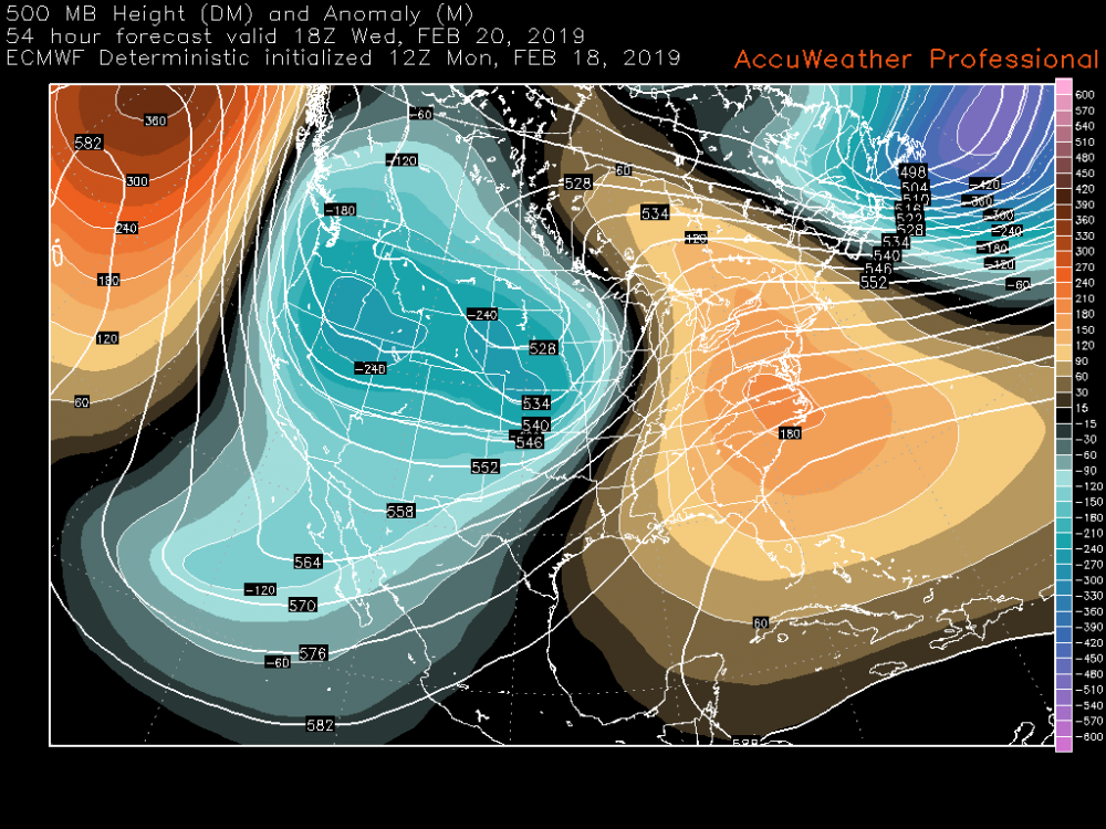
However significant our winter weather impacts end up being, I love the fact that this is our 500mb map at game time.
-
1
-
-
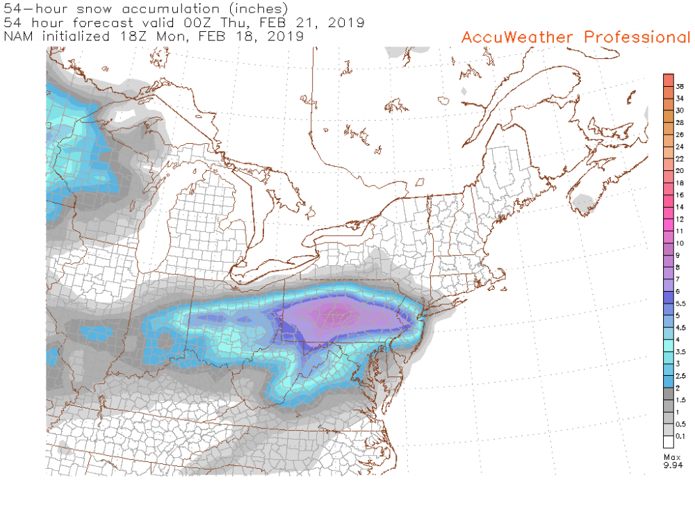
12z and now 18z NAM really making this event a PA thing. Broad area of 6"+ with 6" line reaching all the way to IPT.
This snowmap doesn't include sleet/ice in its snow amounts. Snow maps with Cobb and Kuchera method were similar to this.
-
2
-
-
Wow LWX already tossing up watches over a majority of their coverage region starting 10p on Tues. CTP noting high uncertainty.
Quote.LONG TERM /WEDNESDAY THROUGH SUNDAY/... Uncertainty is very high at this point as to the evolution of precip type and the QPF over PA on Wed. GEFS and SREF plumes play out a QPF range from just a tenth or so to many inches. The temps also range wildly. The GFS warms everyone in Central PA up to plain rain during the day, while the NAM and EC keep it much colder. Will keep mentioning the storm in the HWO, but not enough confidence in many aspects to post a watch. Most likely place to get the worst impacts will be along and S of the PA Turnpike.
I'd imagine if CTP were to have issued any watch headlines they would be residing roughly the bottom two tiers of counties. I have a pretty decent amount of confidence in this being a high impact predominantly winter p-type event in our region. The model positions they mention above in the quoted portion of the disco were the positions for last week's storm. The GFS was definitely not the winner of that with respect to the thermal column. The Euro/NAM handled that storm the best and I don't really see any reason to deviate from that with this one given the similar setup. My biggest concern with this event right now is QPF. It may not impact I-80 north significantly, certainly at least from the standpoint of headlines greater than that of an eventual advisory. A bump north with stuff puts the axis of heaviest potential snow/ice right in the heart of central and LSV, a bump south/more progressive could have the significant impacts along and south of the mason-dixon.
-
2
-
-
33 minutes ago, djr5001 said:
Precip just doesn’t push into PA as much as NAM has been doing. It appears as if around 750mb will be the layer to watch with the warm air push aloft according to most of the models Wednesday afternoon. Models including afternoon and early evening runs of HRRR today have not handled this system tonight well at all across much of PA. The precip has ended several hours early with not much falling at all for a number of locations it seems.
This is another good CAD setup like last week with the difference being the high pressure center is oriented much further south, centered in southern NY and sliding east. This Gulf moisture charged wave is essentially attacking the high directly. So the QPF being further south overall makes sense. It's an interesting setup for sure. You look at a 500mb map and you wouldn't think anywhere in the northeast had the slightest a chance at a winter weather event much less the Mid-Atlantic region. A pretty classic example of life at 500mb not always telling the story of what happens at the level we live on. Although, even looking at 700 and 850 heights wouldn't look really favorable for us at first glance as well. Closed low features at these levels are all the way in the upper midwest when event is impacting. Pretty distinct ridging aloft at 850mb oriented on an axis from New England back through the lakes to the upper Midwest. This feature would appear to help delay/mitigate robust WAA aloft for a time, likely aiding a front end snow threat. Transition to wintry mess likely ensues when WAA aloft eventually does invade the column. 850 and 700mb levels both warm above freezing while 925mb and surface cold are pretty firm the majority of the event, especially central counties.
-
There are some shades to last Tuesday's storm with regards to the Wednesday event progged. There is a fairly decent high progged, although in this present case it seems the high may help keep the best precip more south in our region. I guess that's what ended up happening to a degree with Tuesday's system as well, where the best precipitation ended up in the western and southern portions of PA. This system doesn't have a very defined low pressure center progged right now though like the last one, so we could be talking more of a defined QPF difference as the best precip may get into the southern tier and push out instead of up. Models do show an initial push of precip over pretty much the whole area so not talking anyone getting shut out.
The warm push aloft seems more defined with this system, at least at 850mb. We lose 850mb pretty easily after perhaps some front end snow. Like last time though, the 925mb level holds fast, esp in the central counties but it holds up awhile in the LSV too. So this is likely to be another messy event on tap for us in the p-type department. This winter is starting to remind me of the late 90s(esp 98-99) and 2007-2008, 2008-2009.. where it seemed like we couldn't buy a clean snow event. And those were La-Nina winters. I still think late month and getting into March is where we're going to see if our MJO/SOI influence in the favorable phases has legs. Knocking back a SE ridge isn't necessarily an immediate thing and it especially isn't so when the western trough remains a big player. That we have opportunities for non-rain precipitation this week should be considered a win.
-
1
-
-
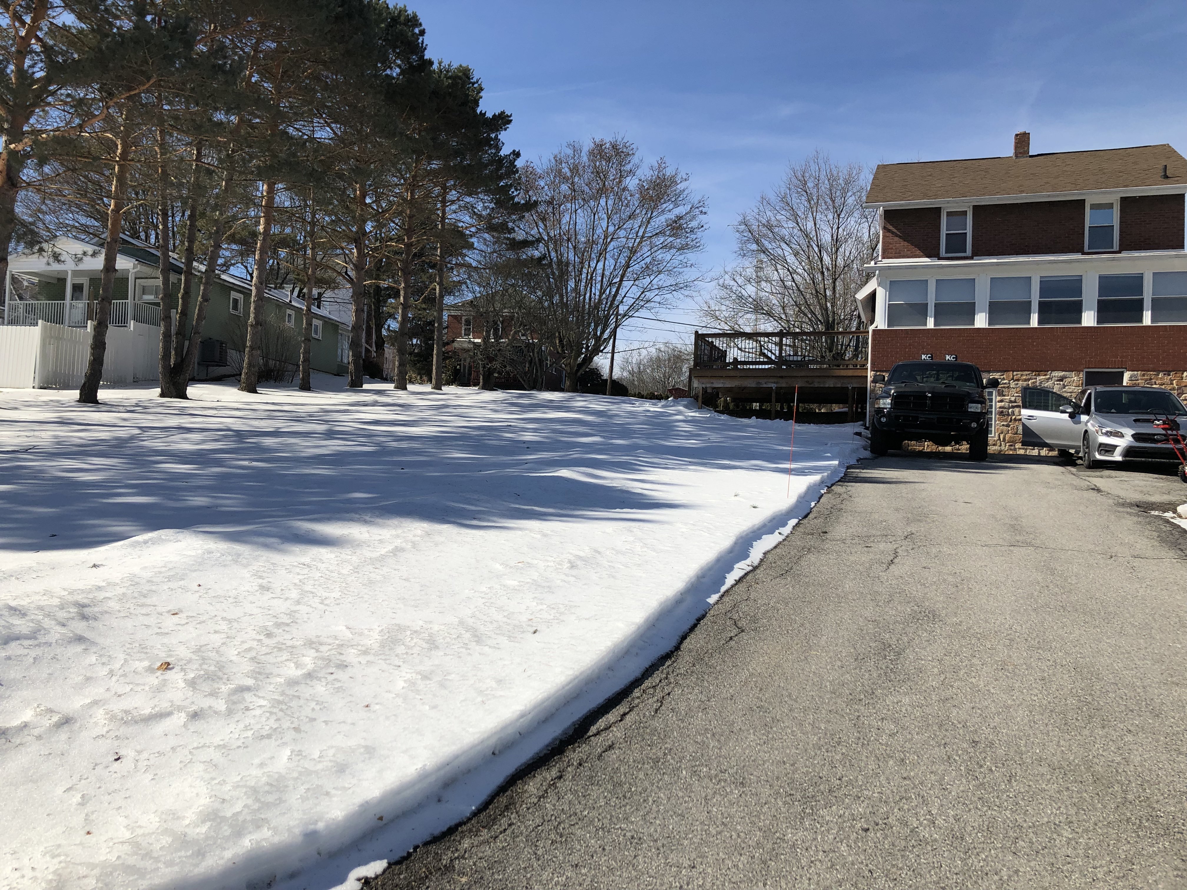
It was a nice day out, cracking into the 50s. Said warmth didn't do much to the glacier in the yard though (still 100% coverage). I was gone most of the day and just got home and went out in the yard to take some measurements. I immediately slipped and fell on top of the snow since it's cooled back off and everything's refreezing. I had a 6" snow depth after the storm Tuesday and I managed some measurements on the north and south side of the house that were all in the 4.5-5" range. That's crazy with how warm it got today (and temps in the 40s yesterday). I guess that's what over 30% of the snowpack being sleet will get you. I'm ready to add to it.

-
1
-


Central PA - Jan/Feb 2019 Obs and Discussion
in Upstate New York/Pennsylvania
Posted
Pretty heavy snow now with a coating already. Bit of a breeze too. Temp down to 26ºF