

MAG5035
-
Posts
5,718 -
Joined
-
Last visited
Content Type
Profiles
Blogs
Forums
American Weather
Media Demo
Store
Gallery
Posts posted by MAG5035
-
-
1 hour ago, bubbler86 said:
Yea on the GFS, that storm is one fast mover and right where much of the LSV would want it for the heaviest snow even with its speed.
There's not much to keep that storm from being a quick mover with the NAO going positive and no high pressure to the north. The key as I mentioned this morning is keeping the low south of PA, which is going to hinge on where the boundary between the cold air and warm air ultimately lies. I think most of C-PA is sitting in a good spot for this, although the southern tier LSV is an area I'd be concerned about for mixing. This event overall strikes me as of the quick hitting 10-12hr 5-10" ish variety for the area that gets the best snow in our region.
-
Things have really come around with regards to tonight into early Fri's event as well as the Sun night/Mon one. For tonight's event I was concerned about sizable corridor of central PA effectively missing out on both yesterdays clipper (too far north) and tonight's (too far south). The NAM was def on the northern end of things and now the rest of the major suite including the GFS is on board with running a snow swath across at least the lower half of PA. Looking like a 2-3" type deal with perhaps some scattered 4-5" amounts (esp Laurel's).
This end of weekend thing after looking rather disorganized the last couple days is now currently looking much more potent with yet another Gulf moisture laden system and the potential for a higher impact winter storm. Missing from this event vs previous couple is presence of high pressure to the north to aid in CAD. Thus, it is important the low tracks south of PA and not through or NW of us. Def looking like more of a gradient type storm with probably not much of a mixing/ice zone. Getting into March can start presenting cold air availablity issues for storms depending on setup but this pattern going forward into probably at least the first 2 weeks of March is primed with a ton of cold air. That coupled with a slight relaxation of the western trough (still running a -PNA) should help suppress the storm track enough to give us a good shot at this weekend event and perhaps more. Overnight Euro really ripped true central PA with some mixing issues southern tier while GFS is tracking more south and providing PA with generally all snow. Top end potential of this storm is probably going to be tempered some as wave will be progressive and the lack of the high to the north also would play into weaker u wind anomalies (low level easterly flow) with the coastal low as progged. Either way, I think all of us would sign up for 6-8" type event.
-
12 minutes ago, canderson said:
At this moment Friday looks like if anything less than 1” and the early week dorm looks like it stays way south - like Virginia south.
With this week decidedly a more northern branch dominated pattern, it appears the better of the two events is going to be the clipper system tomorrow. Unfortunately the low is going to track too far to the north (through PA) so the best snow swath runs NY state/PA northern tier into New England. The system near the weekend (Fri) hasn't been nearly as impressive for the most part the last several runs, although the 18z NAM ran a swath of snow across most of PA.
-
4 hours ago, bubbler86 said:

Lol, I'm shocked. Last week it had that run with 2-4 feet of snow that basically told the Jan 2016 NAM to hold my beer, but then it was all talk and no action.
-
CTP near term:
Quote.NEAR TERM /UNTIL 6 AM MONDAY MORNING/... Strong, damaging winds will buffet the region tonight, as we remain in tight pressure gradient south of intense low over the Grt Lks. Strong subsidence associated with cold advection and resulting steep lapse rates should contribute to occasional gusts in the 50-60kt range overnight. Surface observations early this evening are showing peak gusts to around 50kts from central Pa westward to near Chicago, so this looks to be a fairly long duration wind event. In addition, ASOS doesn`t capture true peak gusts, but rather 5 second averages. Research in this area indicates true 1 second peak gusts are 20% higher. An examination of Bufkit soundings show the best mixing occurring after about 03Z, when gusts of around 60kts appear possible in some spots, mainly over south central Pa. Light, lake enhanced, orographic snow will continue to fall over the northwest mountains overnight. A frozen Lake Erie will limit accumulations and latest model qpf supports totals just shy of the 3 inch advisory criteria. However, a winter wx advisory remains up for the combined effects of snow and blowing snow. The combination of falling temps and strong winds will push wind chills to around zero late tonight over the Allegheny Plateau and down to the mid teens over the Lower Susq Valley. Actual lows should range from the upper teens north to upper 20s southeast.
-
Snow squall working through right now to go with the high winds. It's nasty out.
-
I don't have much of a sample size of big wind events in this neighborhood since moving into my new house June 2017. So I guess I'll see what this one does, it's definitely blowing pretty good outside.
Since it didn't get above 35ºF all weekend until like 10-11am this morning, I still have 100% snowpack coverage in the yard. Quick measurement braving the wind outside has about 6" south side of the house and 7" on the north side.
-
7 hours ago, canderson said:
Yesterday Flagstaff, Arizona, had 35.9” snow!
@Voyager aren’t you headed there this weekend? Lol
That's crazy, the western US has had one heck of a stretch of winter in the last month.
-
2 hours ago, Itstrainingtime said:
So...apparently the 12z Euro today was showing somethin' cookin' at the end of it's run. (time period matches the FV3)
I don't have access to full Euro ensembles but I do have the Euro control run that goes out to 360. It does have an event in that range, kind of a weaker miller-B type deal with some snow in PA and probably marginal thermals in DC. So yea, it had something.. but not the 3-5 feet the FV3 served up lol. 18z FV3 still has a pretty big storm.
-
Welcome to the freaking Ice kingdom
Only got about a tenth ice on the tree branches but the rain on the nearly inch of sleet earlier really made a mess. Overall snow depth with the double ice layer is 8”. Temps still at freezing and freezing drizzle still lingering.
-
 3
3
-
-
Down to some light freezing rain/rain now with maybe a pinger or two and temps at 32ºF. Have measured 0.8" of sleet that's had some freezing rain on it as well. Don't see anything noteworthy in terms of ice accrual on trees/powerlines although I'm sure there is at least a bit and I'm heading out to do some more cleanup. The sleet brings the storm's frozen total to 5.6".
-
Lol this started 40 min ago and there's already about a half inch of sleet accumulated. In the thick of the heavy precip right now. The streets/roadways that were in semi good shape have re-caved.
-
1
-
-
8 minutes ago, bubbler86 said:
Good call from before!
HRRR showing it now as well.

If I end up with another sleet storm like last week I'd have a snowpack til April no matter what the weather did haha.
-
2
-
-
2 minutes ago, slanich said:
So I'm learning here: "latent heat" has been mentioned today -- is that why sometimes we have freezing rain that doesn't freeze, even when surface temps are well below freezing? I never saw / noticed this phenomenon until we moved to central PA (previously lived in Illinois, MD, and northern VA). Thanks!
Heavier downpours of rain (starting as snow above and melting of course) falling through the warm layer aloft will eventually act to warm up the cold layer below, especially if the warm layer is a good bit above freezing. If you have a really warm layer aloft that's pretty thick, like say into the upper 30s-40s.. heavier rain will bring surface temps to freezing and slightly above pretty quickly.
Big raindrops aren't very efficient for accretion on trees/powerlines/etc in most any icing scenario simply because the bigger droplets just splash off. The light to moderate rainfall with finer droplets are the best for ice accrual.
-
Looks to be nearly or all sleet now, accumulating.
-
Heavy, wind driven sleet and some raindrops in there but mainly sleet.
-
1
-
-
Just now, Blizzard of 93 said:
Yes, dew point at MDT is still 26. Temps might drop with heavy precip.
I’ll be interested to see what kind of precip @MAG5035 starts off with this next round.
Looks like a line of thunderstorms coming lol.

-
 2
2
-
-
Next wave of precip coming from Pittsburgh closing in fast. I'll know pretty soon what kind of wintry mix I'll be contending with. Temp hanging around 29ºF.
-
1
-
-
21 minutes ago, daxx said:
We just gotta make it through this spring like weekend. After this blip I think we will be tracking threats again. Heck we might be tracking threats before it even turns cold again. I think that you are right that something special could be coming. It would be a great way to close winter.
I'm already eyeing up the freezing rain showing up on the NAM in the central 1/3 of PA on the front end of the cutter Sun morning. Euro was close to that and only briefly had the far southern tier warm.
-
Just now, bubbler86 said:
I was just typing up a post about the fact that if we had held on to moderate precip a few hours longer I think it would have stayed snow and we would all be talking about the best snow of the year...and that even now it is below freezing at 700MB. If anything one could argue that precip right now or even 4 hours from now would lower the temps a bit at the surface at least for my locale.
Yea the precip flew through and shut off a little quicker than expected. We did still see warning amounts but they appear to have stayed turnpike and south. I ended up a couple inches short but still an impressive snowfall this morning. I think a lot of us are seeing freezing drizzle right now because we lost the mid-level seeding after the main snowfall pushed away. That just leaves us with the low level stuff right now. You can see that looking at the different tilts on the CCX radar. Turn it to tilt 3 and theres nothing on radar once the beam is above 7k feet.
-
1 hour ago, bubbler86 said:
Check out this panel. Did not notice this much before but it is saying there is going to be a sleet bomb north of Harrisburg tonight.
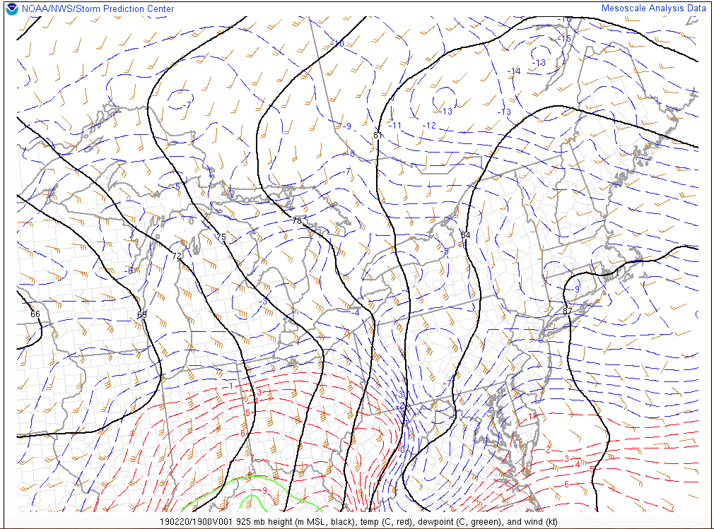
The key to the ice later on is going to be depth of the low level cold. I look at 925mb (3k feet) temps as a big factor with sleet vs freezing rain. Short/near term models had prolific freezing rain amounts last week as well, but cold up thru 925mb or so held firm and we had a good bit of sleet and not much freezing rain. Looking at mesoanalysis, we're still below freezing at all levels in PA from the Laurels east (surface, 925, 850, 700mb). 925mb is the coldest, with a large portion of PA being shown at -7ºC (19ºF). It's gonna take awhile to route that out, so I think when we bring in the second wave of precip later.. I don't think it'll be completely freezing rain.

-
3
-
-
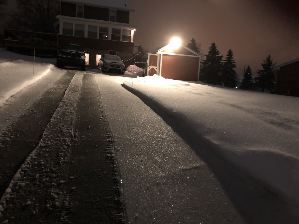
Freezing drizzle here with a very light crust on the new snow and 27ºF. 4.8" is my total snowfall for now barring whatever sleet we get later. Wind has been a thing here today, quite a bit more blustery than I was expecting. It was blowing and drifting the intense snow around this morning and making it lovely with the freezing drizzle currently.
-
Still snowing but def a lot lighter at the moment.
-
Pounding sideways snow, it looks like it may lighten up though pretty soon. Working on 5 inches.


Central PA Feb/March 2019 Disco: More Snow In Our Future?
in Upstate New York/Pennsylvania
Posted
0z NAM is pretty similar to what the 12z Euro had today with regards to the Sunday night-Mon system, and that's generally been a winning combo in the short-intermediate range when those two are on the same page. So we'll see how the rest of 0z evolves with that system. Western and Central PA get ripped on those two solutions. Actually just about the whole state sans the Philly region do but the issue in our subforum is the very far southern tier along the PA/MD line and potential mixing/rain. The GFS has been a more southern solution but given how it handled tonight's system up until about yesterday or so.. It may be running these systems too far south in the pattern we have this week.
Once again, this system does not look to have a high to the north. This low will be running strictly on wherever the gradient sets and we won't have a CAD setup. So instead of a large mixing area, we'll likely have an actual rain/snow line for a change or perhaps a very narrow mixing area. You can see that illustrated on the P-type map from the NAM, for example. Establishment of some fresh snowpack tonight and perhaps tomorrow night for some areas can only help.