

MAG5035
-
Posts
5,718 -
Joined
-
Last visited
Content Type
Profiles
Blogs
Forums
American Weather
Media Demo
Store
Gallery
Posts posted by MAG5035
-
-
3 hours ago, canderson said:
Someone in this subforum is going to see some significant gusts and crazy lightning tonight methinks.
Def one of the more confident and stronger worded special weather statements I've seen for the area. Severe watch issuance is a quite likely and potentially may come with a tornado watch for the southern counties for potential QLCS tornadoes given the dynamics. Winds not very far aloft are screaming, even 850mb winds on mesoanalysis are showing 45-55 knots over PA. It won't take much for the impending squall line to tap down severe wind gusts. Some CAPE being shown in the south central as well (few to several hundred J/kg) which is notable in this type of later fall setup with the high low level shear present. This lends to the potential for QLCS tornadoes imbedded within the squall line.
QuoteSpecial Weather Statement National Weather Service State College PA 212 PM EDT Thu Oct 31 2019 PAZ004>006-010>012-017>019-024>028-033>037-041-042-045-046- 049>053-056>059-063>066-312215- Warren-McKean-Potter-Elk-Cameron-Northern Clinton-Clearfield- Northern Centre-Southern Centre-Cambria-Blair-Huntingdon-Mifflin- Juniata-Somerset-Bedford-Fulton-Franklin-Tioga-Northern Lycoming- Sullivan-Southern Clinton-Southern Lycoming-Union-Snyder-Montour- Northumberland-Columbia-Perry-Dauphin-Schuylkill-Lebanon- Cumberland-Adams-York-Lancaster- 212 PM EDT Thu Oct 31 2019 ...Severe Weather Expected Later This Afternoon into the Evening Hours... A line of severe thunderstorms is expected to cross Central Pennsylvania, roughly between 5 and 10 pm. Some areas will see damaging wind gusts of 60 to 80 mph along this line of storms. Given how strong the winds are in the lower levels of the atmosphere, isolated tornadoes are also a possibility. Here is some initial timing as to when severe weather is expected: Bradford from 5-6 pm, Coudersport, Johnstown, and Somerset County from 6-7 pm, Wellsboro, Lock Haven, State College, and Altoona from 7-8 pm, Williamsport, Sunbury, Lewistown, and Carlisle from 730-830 pm, and Laporte, Bloomsburg, Shamokin, Harrisburg, and Lancaster from 8-930 pm. Please stay tuned for the latest weather updates, including the likely issuances of watches and warnings later today.
Lastly, the Laurel's/Alleghenies will be seeing their first flakes of the season late tonight/early tomorrow morning with the remaining moisture behind the front. This may also include the immediate central areas off the Laurel's (UNV/AOO region). Any accums should be little to none, but some of the highest Laurel's areas could get a coating.
-
On 9/2/2019 at 4:45 PM, Voyager said:
Thanks MAG!
Next interest is the 21-23 timeframe when the wife and I do her birthday vacation in Cape May. The Atlantic basin has become quite active, so I'll be watching the tropics for the next few weeks.
OCMD now in a tropical storm watch that was issued earlier on, as I'm sure your aware. You might get to see some action after all.
-
35 minutes ago, canderson said:
I had water coming through my doorknobs during Irene. It was worse than Sandy, far more severe wind.
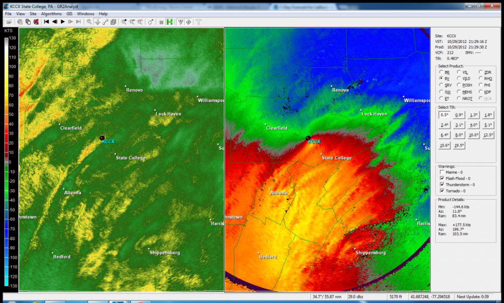
Sandy was definitely the windiest system here of any recent central PA major tropical system incursions, which back this way would involve Fran (96), Isabel (03), Frances (04), and Ivan (04). The flooding issues of the latter two are certainly well documented but they didn't have too much wind. Sandy of course was an extremely anomalous event all around. It was several hours of near constant wind, which we ended up losing a tree or two out of it. But just a couple miles away there was an area that pretty much a whole section of woods got laid out from the high winds. I probably still have the velocity image somewhere on my laptop of the 80-90kt velocities over the whole area.
Edit, I found it:
-
3 hours ago, Voyager said:
I'll be in a boardwalk motel, but not sure of surge with a NE track and winds from the north parallel to the beach. I guess I "shouldn't" hope for a closer in track, but I am a weenie, so...lol
There will certainly be the usual issues of high surf/riptides/beach erosion and perhaps some minor coastal flooding as the hurricane eventually gets lifted up past that region. But the storm track vs the orientation of the coastline there probably would suggest not too many major issues. A track on the farther western envelope of guidance would likely involve Dorian passing thru mainland NC to get there, so you'd be talking a weaker system in that case. Although, the storm center passing very close would invite at least some storm surge potential (likely 2-4ft type stuff). Model guidance has generally been keeping if fairly far offshore from Ocean City, MD after getting very close to the Carolina's and perhaps impacting the Outer Banks region. So OCMD could get into some of the outer stuff, but the core of what's left of Dorian at that point looks to stay offshore. It will be also be moving much quicker at that stage of the game too as it's being picked up. That's my take on it currently, obviously there's still a lot of questions yet surrounding what this hurricane is going to do. Ocean City could also decide to be cautious and evacuate tourists out till the storm passes if it were to end up coming very close.
This could also be interesting at the coastal New England/Nova Scotia level, 12z Euro looked to phase in some energy to a probable extratropical transitioning Dorian and make for a pretty significant impact on Nova Scotia.
-
 1
1
-
-
3 hours ago, Bubbler86 said:
I was in Florida for Matthew, about 40 miles inland, and we had nothing more than a few sprinkles. An east coast grazer will cause damage right on the coast of Florida but is a non event for most of the peninsula. Man, if the Euro is right there is a chance for more than rain here. If Dorian starts meandering up the coast and maintains intensity it could be pulled in just like any other low in the winter. Phase and Susq. Valley is getting a Hurricane. Rehoboth Beach is no picnic either. Today's models have really sent the alert out to the whole eastern seaboard up into Nova Scotia.
While it's quite early in the game for pondering such things, I don't particularly think our region is going to see effects from Dorian save for maybe glancing the southern LSV portions of the subforum with some rain or something. Typically to bring one of these storms into our region you need downstream ridging/blocking in eastern Canada and the western Atlantic and I'm not quite seeing that on the models. Once the storm curves it's going to eventually be picked up and shot north/northeast after really slowing down on it's approach to Florida. So in terms of the rest of the SE coast and eastern seaboard/coastal plain up to New England, yea I would certainly be keeping an eye on the developments of it. But for our region at this point I think it's unlikely.
The 12z Euro is interesting that it keeps Dorian off the Florida Coast, perhaps even sparing the coast much hurricane strength impacts if it continues to be on the smaller side in terms of extent of hurricane force winds. It will be interesting to see how this evolves the next day or two. This will be a very strong hurricane on approach to Florida, likely a cat 4 and perhaps a high end one at that. If it in fact largely stays offshore of Florida then the SC/NC coast would be under the gun for a stronger potential impact. Although typically in these cases it would feature a weakened hurricane to some degree with influences from being picked up and waters that are warm but not quite as warm as it is in now. Def still major hurricane potential (Cat 3) but I think Florida would see the top strength of Dorian if it made landfall there (Cat 4 potentially).
-
 1
1
-
-
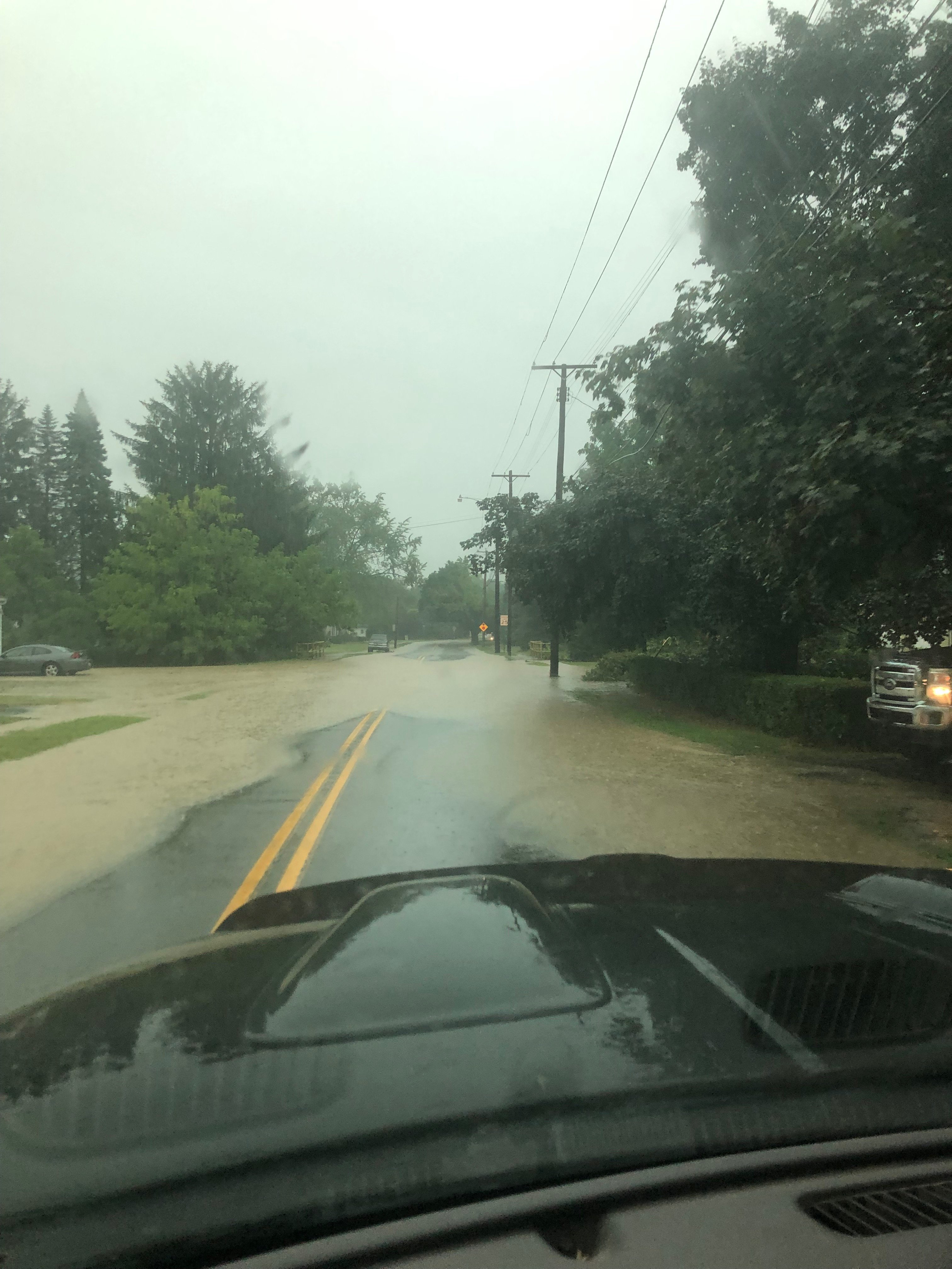
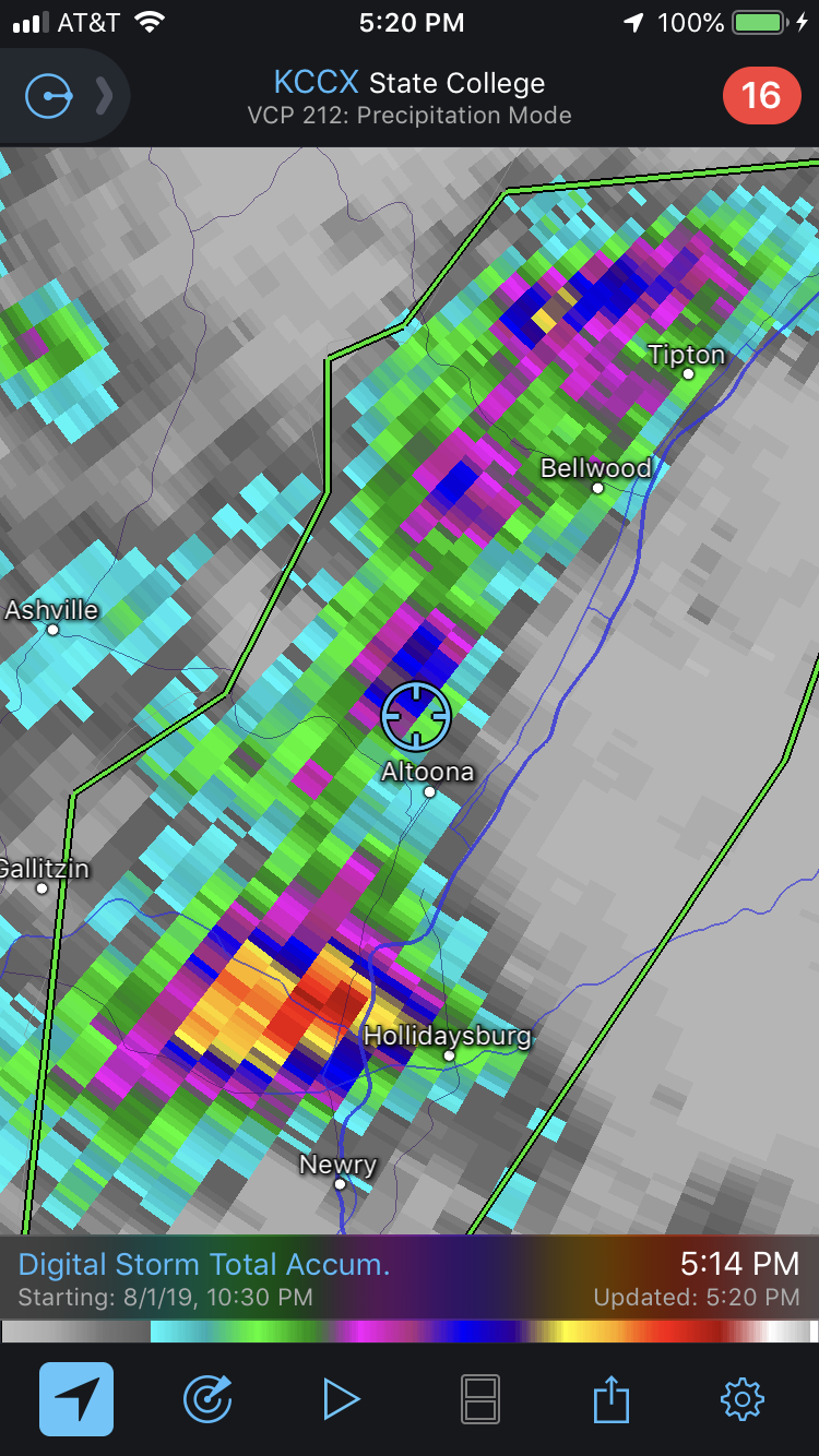
Well it had been drying out pretty nicely around here in the last few weeks. Then today happened:


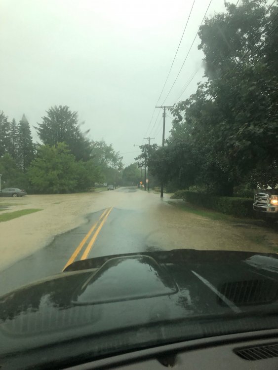
I was on the edge of the approximately 3" or so area on the doppler estimate.. and that all fell in the better part of an hour or so. Also the worst lightning storm I've seen in awhile.
-
2
-
-
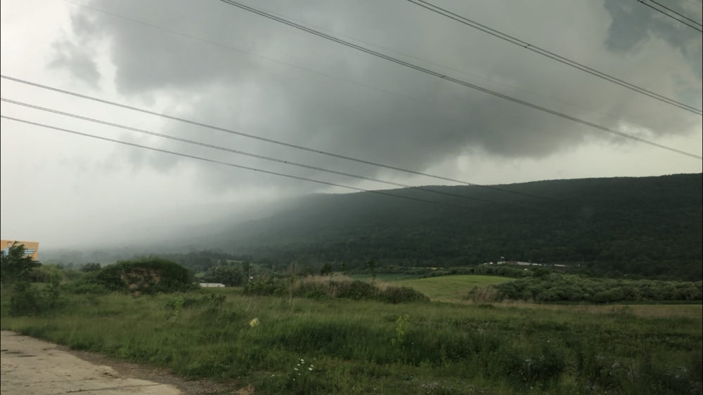
Here was a screenshot picture off one of the videos I took this afternoon. Looking north toward the hook and the meso crossing over the mountain. I made a good intercept considering I rarely get a chance to do such things around the immediate area. This one wasn’t strong enough to drop a funnel but as I said earlier it did have rotation.
-
3
-
-
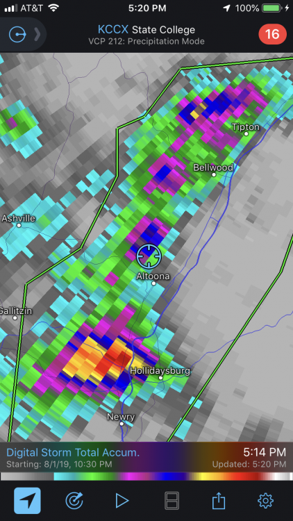
I’m in Bellwood right now so i probably won’t have to go anywhere to see what happens with the hook echo on the cell bearing down.
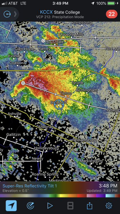
EDIT: I forgot to hit send on this. Ended up going a couple miles south on a hill to get below the hook and have a look. There was definitely rotation but no funnel that I could see.
-
Wow, a near state-wide tornado watch just issued for PA.
59 minutes ago, Atomixwx said:Still overcast in Wertzville. Not feeling it today.
I think things will clear out more in the Sus Valley as we get into the later afternoon, which is evident on satellite. Mesoanalysis is showing pretty big CAPE already advected into the western and central counties.. on the order of >3000 j/kg (surface based). A lot of mesoanalysis parameters look fairly impressive for this neck of the woods. The combination of the large CAPE and modest helicity has 0-1km EHI numbers >1 and in the 2-4 range (most in northern PA attm) over a big portion of central/western PA. That in itself is a solid indicator of a tornadic threat from thunderstorms today.
Pretty high bulk shear numbers and bulk richardson numbers (BRN) in the 10-45 range over a good portion of central PA would suggest cellular and supercells as the dominant storm mode today vs lines or clusters. Large hail is also a notable threat as well given the large CAPE. There is definitely high potential for a pretty significant severe outbreak late this afternoon.
-
8 minutes ago, Bubbler86 said:
That line over N/W PA is pretty crazy as well.
Yea there's a couple bowing segments in the main line, with the most notable section that was tornado warned having impacted Warren a bit ago. Most impressive portion of the line seems to be I-80 north in PA at the moment.
Primary threat with this overnight is of the QLCS variety, which presents the potential for brief tornadoes imbedded in some of the bowed segments in addition to the high likelihood of severe thunderstorm wind gusts. That's the general basis for the tornado watch issued for most of the commonwealth. Winds aloft are pretty significant (50-60kt at 850mb), so not going to take much to mix that down given central PA having busted into the warm sector. I know it's already been quite windy here this evening without the storms.
Was looking at mesoanalysis and this severe threat could have been a much more serious one had we had the daytime heating/CAPE element to things. This is a very impressive setup dynamically. Effective bulk shear and helicity numbers are VERY high right now in Central PA. Any kind of half decent CAPE would have sent the EHI parameter through the roof (one indicator for strong tornadoes). I'd say if this setup would have been shifted back 6-8 hours and central PA would have cleared some today and got sun and daytime heating this threat could well have been one with more discrete storm cell activity ahead of the front. This could have been a more traditional severe outbreak with very high tornadic potential.
-
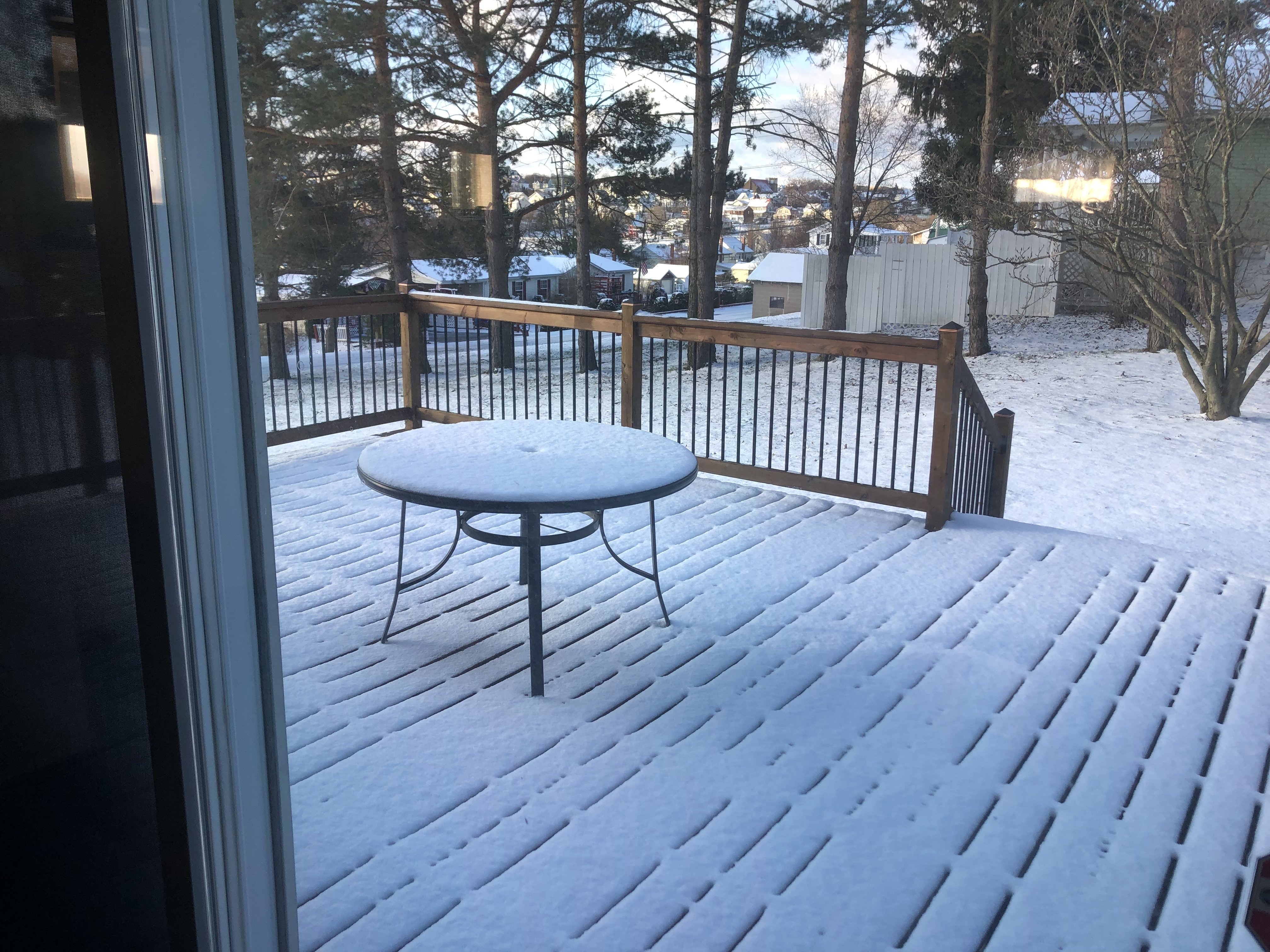
An inch on the ground this morning, after a 70ish degree day Saturday.

-
1
-
-
I think it'd be more of an April Fool's joke if I were to post that it wasn't snowing outside here. A major snow squall occurring right now with accums on the ground (coating), heck I might have to measure if it keeps up.
-
1
-
-
Still somewhat of a rain/snow mix here at 1300’ (mostly rain attm). Took my drive up the road and light accums started around 1500-1600’ and ended up with an inch or so by the top (2400’+).
Pic is 4.2 miles from my house (same spot as last week)

-
1
-
-
Lol you guys are all talking spring fling in here and guess what? It’s snowing here currently.
-
3 minutes ago, Itstrainingtime said:
Just passed 2" here with moderate rain falling.
If only...
I've been thinking that too, that low couldn't have tracked any better for us in here.
-
4 hours ago, Festus said:
My point and click for Friday says - "A chance of rain showers before 8am, then a chance of rain and snow showers after noon. Some thunder is also possible. Partly sunny, with a high near 50."
Squall line potential like the other day?
Not necessarily squall line potential but there will be a ton of instability tomorrow in the wake of our deepening coastal storm. The strong late March sun that will likely come out at times esp in the Sus Valley and south central and surface heating vs the cold air aloft will definitely ensure low level instability and numerous pop up rain/snow showers (likely in more cellular fashion). There will also be decent instability at the mid levels too with the very deep closed 500mb low over the NE bringing in a lobe of -35 to -40ªC air over PA tomorrow afternoon/evening at the 500mb level. Should be some feisty showers of whatever tomorrow.. probably more snow in the Laurels/central counties and rain in the Sus Valley. This is the type of setup that graupel is quite possible too along with rumbles of thunder.
-
Snowiest 511 cam I can find at the moment in C-PA surprisingly is the Sideling Hill US 30 cam in Fulton County. This is east of Breezewood and just south of the turnpike.

-
27 minutes ago, Blizzard of 93 said:
Congrats MAG !
What are your thoughts on the winter storm chance for early next week ?
I think there's a chance but it looks to come down to timing of the potential wave vs the press of the cold air boundary. Too quick and its too far north and too late and best precip runs south of the area. 18z GFS looked suggestive of a rain to snow scenario as the cold presses south with the wave moving through our region. That would obviously be a risky scenario this time of the year. Still pretty decent lead time for resolving details with that one.
-
The situation 5 miles (and +1200’ elev) away, S+ and accums starting.

Down here it’s mainly rain with cat paws/slush drops. Full transition looked to be about 1600-1800’. Looking at all the bright banding on CCX radar essentially down to right over the radar. This thing was about 2 or 3 degrees at the surface-925mb level from being a paste bomb in the AOO-UNV region.
-
Saw some mPING obs with rain/snow around State College. Blue Knob ski resort has snow falling. Looked like a bit of accumulation too judging by their f-book pics.
-
I kinda hope I get little or nothing precip wise out of this coastal system haha. After months of being so wet and finally starting to dry things out around the yard to where I can actually walk on it now.. I think I'd take high and dry over a rainstorm or a rain/snow mix that amounted to little or nothing in the snow department. I'm pretty much at the point of the season where my weather preferences would be as follows:
1. Big time snow storm
2. Warm and dry
3. Cold and dry
4. Advisory snow that probably lasts a day or less on the ground
5. Rain
-
10 hours ago, psuhoffman said:
This might be my perspective being used to posting in the mid-atlantic forum...plus I live right along the border between the two forums so I am the southeastern EDGE of your region. About 7 days ago super long range guidance had "teased" the mid Atlantic (DC/Baltimore) area with snow solutions from this storm. Then for a while the guidance started to squash the storm completely. I was kind of explaining why now that it has trended back towards a storm it also became wet vs white. A week ago when it was teasing with a chance of snow the evolution was different. That initial upper level low swinging through the midwest was diving into the trough and phasing with the STJ over the southeast and pulling the NS into the system... Basically the NS was phasing into the STJ system and bombing the whole thing to our southeast. What is actually happening now is a third piece of energy from the NS is diving into the lakes...and both the midwest upper energy and the STJ energy over the southeast are being pulled up and phasing into that. The phase is happening way further north then those runs that teased snow for the DC area a long time ago. So its the same storm, sorta, but the evolution is completely different. The key energy over the lakes that ended up bringing this back wasn't even on the radar 5 days ago. It might still work out for places further north...the NW half of this forum northward, for instance, but its a crap setup for the southeast part of this region and all of the mid atlantic region...and for the coastal northeast for that matter.
Yea I remember that Euro control run about a week or so ago in particular that detonated that huge storm (this upcoming coastal). That particular model run actually had the third shortwave that drops out of Hudson Bay (which is notable on models in the much nearer term now) and that run phased everything in a manner that gave that 960mb off the Delmarva solution... making it look quite like a triple phase type thing with three shortwaves involved. I actually commented on it back on the 11th (page 54). At the time the other models only had two shortwaves interacting and not the one that came right out of Hudson Bay, making less explosive solutions than that one was.
9 days and a lot of different coastal and non coastal solutions later and we actually have ended up settling on what looks like a decent coastal storm but as has been noted by you guys, via a later and further north phase. With more cold available up front this still could have been salvaged as a nice snowstorm even down into parts of the Mid-Atlantic subforum. You look at thicknesses and 540 line is into the Sus Valley, but that's more a result of the levels above 850mb as the lower levels 850mb and under are going to be cool and pretty isothermal but still too warm. I do think this ended up really close to being something pretty big. The heavy precip band northern MD up into the Sus Valley certainly indicates decent dynamics involved. I'd still watch elevational areas in NE and perhaps some of North Central PA above IPT.
-
1
-
-
4 hours ago, psuhoffman said:
Problem for this weeks system is instead of the NS diving in and phasing into the coastal there is a system diving into the lakes that pulls both the energy coming from the west and the developing coastal up into it. The southern system phases into the NS instead of the other way around. On top of that the system in the lakes allows the flow to turn southerly and wreck the low and mid levels.
There could be a surprise thump snow somewhere across central PA though if the banding can pull down enough cold air. It’s close enough that I wouldn’t rule that out, especially in higher elevations.
The NAM seems to be presenting the best scenario for a potential rain to snow ordeal (def elevational) being the furthest west and focusing heavier precip into the central areas that are higher overall. I don't think the setup is necessarily terrible from the standpoint of how the storm develops and tracks but there's just not a lot of surface/low-mid level cold to work with until the rapidly deepening coastal has lifted away. 0z Euro has quite an intense band of QPF thru the Sus Valley into NE PA similar to the NAM (precip only edges central counties though) but low level thermals just aren't there at 925mb and surface and marginal at 850mb. It's hard to do marginal in late March outside of the higher elevations... so I see two potential areas we could see a wet snow threat evolve. The Laurels and higher ridge and valley region in the central third of the state (provided heavier precip set up that far back), or perhaps the more likely area.. the Poconos region of NE PA. The Euro did light up some accums in NE PA.
-
Light dusting of snow and flakes flying around this morning after cracking 70+ the last couple days. March, lol.
-
1
-


Fall/Early Winter 2019 Forecasts and Discussion
in Upstate New York/Pennsylvania
Posted
FROPA came through here with torrential rain but very little wind. Stable boundary layer stayed pretty firm here as it usually does in these type of situations. Probably will be another couple hours before things finally get mixed out post front and the winds ramp up.