

MAG5035
-
Posts
5,718 -
Joined
-
Last visited
Content Type
Profiles
Blogs
Forums
American Weather
Media Demo
Store
Gallery
Posts posted by MAG5035
-
-
Moderate sleet, I cleared a spot to start measuring that and I'm at roughly 1/4" accumulation.
-
6 minutes ago, djr5001 said:
Looking at correlation coefficient imagery from the radars and mPing reports the ptype transition line is racing north and east much faster than I was expecting but with low track to our west honestly I’m not surprised... starting to wonder if more icing ends up occurring around here than was expected. Cold near surface will hold but aloft not looking likely.
Unlike on the other side of the Alleghenies (SW PA), we have the benefit of it being really cold up through 925mb (~3k feet). The 850-800mb (5-6k feet) layer is what were rapidly losing, as it wasn't very cold to start with for this event. So while it's looking like the mixing is going to probably get way up into the north central eventually, it's going to be predominantly sleet for most of us. I think any ZR will be confined to the Laurel's and possibly southern tier under the turnpike. Pretty much what the NAM had been advertising for several runs leading up to this. It had the strongest punch of 850mb temps but kept the 925mb layer very cold.
-
I'm over to full pingers now. 1.2" and 25ºF. Maybe if the NAM sleet bomb verifies I'll end up with more sleet accumulation than snow lol.
-
Still mostly snow but signs of a transition being pretty close. Rimed flakes and visibility is up. 1.1" has fallen.
-
6 minutes ago, Blizzard of 93 said:
Nice !
I swiped these maps from the Mid-Atlantic thread. The cold air at both levels seems wedged in much deeper over the eastern half of PA. Hopefully that bodes well for a few hours of good snow when the rates pick back up.
Yea hopefully, I'm already riding the edge here. I'll def know if it switches with the stiff breeze outside haha. Judging by that sounding from PBZ's 12z weather balloon this morning, that mesoanalysis looks like it might be running cold, especially at 850mb. We're definitely anchored in 925mb and under though.
-
Snowing heavily, big flakes.
-
 1
1
-
-
Some light snow is restarting with arrival of the main batch. That mix line looks like it's already making a hard push past JST after blowing through Pittsburgh/SW PA, so will have to see what happens here when the heavier stuff gets here soon. The NAM is looking like it might end up being the more accurate depiction with what it's been showing. But again, we'll see how the column responds to the heavier precip. We have a much deeper wedge of low level cold air east of the Laurel's
-
It’s cold out, these are the kinda temperatures you wish you had in place for a Gulf low heading to the Delmarva.
-
1
-
-
2 minutes ago, Voyager said:
As expected, the very first wave out ahead of the 25-30dbz band was virga. Time to run to the store before the 1st actual band gets here.
What do you think, MAG, for my far eastern area of CTP? All snow, or does that warm nose make it here as well?
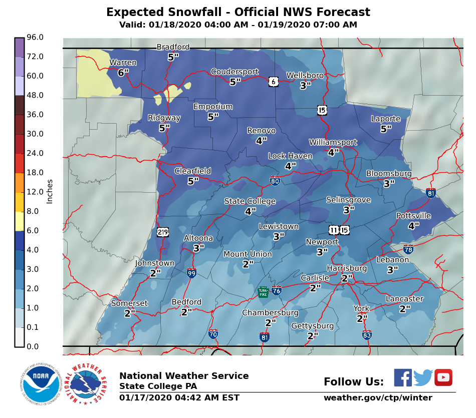
I definitely think mostly frozen.. I bet you probably mix at some point but it would be sleet. CTP has you in 4-6" which I think is doable for you.. since your so far east and your also north too I'm sure you'll at least get to advisory criteria fairly easily as your pretty safely in the deeper CAD.
Really interested to see what happens with this main wave just getting ready to get to Pittsburgh, it looks quite heavy and that gap between waves is closing up pretty fast. I see a couple mPing reports of snow across the border in Ohio under that heavy stuff.
-
Steady moderate snow now, it is definitely a nice wintry morning out there with temps in the low 20s and a stiff breeze. Pretty fluffy snow.
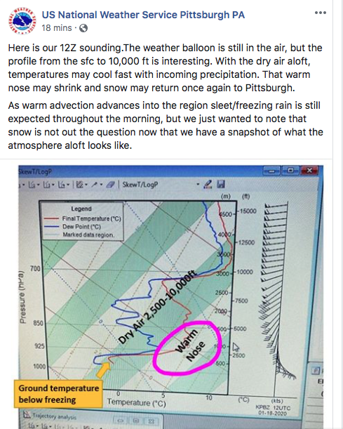
Shared this with the Pittsburgh folks and might as well throw it over here too, as it has implications for us downstream as well. Their 12z weather balloon launch this morning, so that's where the atmosphere is actually at and not where it's modeled at. Mentioned last night how high res models like the HRRR were collapsing the snow line south when it got into central and the Sus Valley, well that weather balloon sounding would be how that would happen even if there's a bit of a lull ahead of the main stuff and temps aloft sneak above freezing.
-
2
-
-
Sharing this with you guys.. saw NWS Pittsburgh post this not too long ago. Something to keep an eye on when that main precip arrives. That's their 12z weather balloon launch so that's the actual assessment of the column and not the modeled one. Definitely plenty of room to wet bulb that warm nose back below freezing with the arrival of the heavier precip. Hopefully you guys can sneak some more snow out of this.

-
2
-
-
3 minutes ago, 2001kx said:
Snow is just starting here
Think your going to be in a pretty decent spot for this one.
-
0.6" with that opening burst of snow. Steady light snow now and a pretty decent easterly/southeasterly breeze with temps now down to 23ºF.
-
Okay, over to all snow now coming down hard.
@Blizzard of 93 the gap in precip doesn't look too large on PBZ radar, plus we've had some building of the initial wave of precip moving in from the western counties. I don't think we'll see too long of a lull in the precip, which is probably good because the really brief bout of sleet indicates to me that there was some robust warming aloft and the heavy precip wet bulbed that portion of the column back below freezing. Will have to see what it does once this heavy portion gets through here and the precip lightens up some. But yea, don't be surprised if that opening wave has a couple pingers in it when it gets to H-burg.
-
11 minutes ago, Blizzard of 93 said:
Please let us know how that initial band does for you.
Also, do you think the precip will begin to fill in more between the initial band & the main shield in Ohio ?
Well, got the heavy echoes overhead and there's fine pingers mixed in already. So that's not really the start I was looking for. But we'll see how the column responds.
Edit: Starting to get the big flakes
-
Snow has started here, 25ºF. Saw NWS Pittsburgh post about having 1.1" with that initial band of snowfall earlier so hopefully can get a fast start here.
-
1
-
-
21 minutes ago, Blizzard of 93 said:
That forcing looks good for the LSV. Hopefully it will help to sustain good precip rates to fight off the mixing as long as possible tomorrow.
We will also need to keep our eye on the critical thickness levels as well.

Specifically that yellow thickness line that corresponds to the 850mb-700mb thickness in this situation. That's more specifically where we will see the column potentially go above freezing during the main precip portion from the WAA. Because of the warming in the mid levels 700-500mb, this is a situation that will snow above the traditional 5400 thickness number.
-
1
-
-
5 minutes ago, Bubbler86 said:
And I did not mean to not mention the deep colors out your way. I do have an LSV slant to my posts sometimes.
Oh nah your fine, was just pointing out the terrain under where it is putting out those high totals.
-
21 minutes ago, Bubbler86 said:
Yea, it really lite up the Mason Dixon with an extremely heavy line of sleet. LSV never goes above freezing. 3K Sleet map from MA:

Geesh.. the most distinct line is running the east slope of the Allegheny front, which I'm within that zone. It's probably not exaggerating too much on the excessive sleet totals if the NAM is in fact correct with the heavy sleet scenario it has been putting out. Lot of the LSV in the 0.5-1" range. Even that much sleet on a couple inches of snow does wonders with anchoring the snowpack lol.
-
11 hours ago, Atomixwx said:
The dry slot, I'm okay with. I have plans in Altoona tomorrow night for the McGregor fight and would really not have to cancel that, so if we can squeeze some accumulation out in the morning and shut it down after that, I would be quite alright with that.
Oh boy there goes the neighborhood haha.
-
This is getting into the range where I start weighing the near term and high resolution guidance more over the globals. Early looks at the HRRR with the first parts of the storm show a pretty decent burst of precip with the initial mid level WAA. Hopefully that gets realized on the ground and it doesn't take long to overcome whats going to be a dry airmass. Right now I think an inch or so looks good with that initial wave. The HRRR is showing the break in precip (although above I-80 doesn't have a break) but it also showing the main wave starting as snow even in Pittsburgh, which should bode well in the central counties and LSV. The 0z HRRR will be running shortly, and the 0,6,12,and 18z runs go out to 36 hours. So that will be something to have a look at within the next hour to see where things are at according to that. The 18z extended run really collapsed the rain/snow line down towards the mason/dixon line as the main wave pressed into the LSV. It might be light on the QPF though.. it's showing only a couple tenths of precip total in the south central and parts of LSV esp below the turnpike. Heck parts of Franklin county barely get a tenth. Probably too dry, but given the westerly component to this event with the low tracking across through the lakes above PA.. we might have to keep an eye out for a precip min east of the mountains in the southern tier.
I generally agree with what CTP has out snow wise. Overachieving on snow totals in the majority of the area below I-80 is going to hinge on the magnitude of warm advection aloft. I think this is primarily a frozen event for us, but there might be a decent bout of sleet. On the other hand, heavy precip coming in could collapse the column enough to maintain snow for awhile with the main wave if there's more wiggle room with the wet bulbs.. which is a fair possibility. I don't think that initial wave completely saturates it. Temps probably will go a bit above freezing over most of the area for a time tomorrow evening after the main precip is past and the occluded front comes through and mixes out the cold at the low levels.
-
2
-
-
The opening take from CTP this morning:
 Quote
Quote.SHORT TERM /6 PM THIS EVENING THROUGH SATURDAY NIGHT/... With the Saturday storm system coming into range of the hi-res models, we are starting to see a better picture of how the storm may pan out. The 3km NAM depicts a narrow band of moderate to potentially heavy snow developing in Ohio Friday night and pushing northeastward into the Laurels by about 09z-12z Sat. This band of snow is collocated with frontogenesis in the 700-600 mb layer at the leading edge of mid-level warm air advection. Expect some ascent above this layer, including through the dendritic growth zone. If this solution pans out, there would likely be a 2-3 hour period of moderate snow at the onset of snow on Saturday morning. HREF shows potential for 0.5-1.0 inch/hr rates with this band. Some lower-res guidance also supports potential for a band of mod snow at onset. Limiting factor for snow intensity at onset may be dry air at low levels. Model consensus supports a roughly 8-hour period of moderate overrunning precipitation during the daylight hours of Saturday associated with passage of anomalous low level jet. The main area of model spread and forecast uncertainty revolves around how quickly warm air aloft works in. Some of the latest operational guidance supports a rapid change to mixed precip over all of the area during the time of heaviest precip. However, the NBM max wet bulbs aloft indicate precipitation remaining all snow across the northern mountains through early evening. WPC guidance supports advisory type snowfall across a large portion of the area. However, given the current uncertainty, have decided to hold off on advisories until a new set of guidance arrives later today. A look at WPC Superensemble plumes indicates plenty of spread with mean snowfall by Sat evening right around bottom end advisory levels. Expect travel conditions to improve Saturday evening, as precipitation tapers off and temperatures rise above freezing in many locations ahead of approaching cold/occluded front. Lake enhanced, orographic snow showers will resume later Saturday night across the Allegheny Plateau, as cold air sweeps in behind departing storm.-
2
-
-
45 minutes ago, Blizzard of 93 said:
There is a nice snow shower rolling through Marysville. There is a light covering outside again. I might need to put .1 or .2 in the books for today between the 2 snow showers.
The snow shower action has stuck around longer tonight than I would have expected, and gotten pretty far into the LSV at times. Tried to do some measuring and I'm going to call it about an inch total for the snow this evening. Hard to measure because it was really blowing around when the squalls were moving through. A lot of the yard had 1.5-2" but the grass is still thick enough to skew that measurement. I finally made an actual 24" x 24" snowboard that will be ready to be put out for Saturday's storm.
-
1
-
-
I’m just gonna hope this snow band dropping down takes care of the front end snow in advance haha.
-
1
-
Central PA - Late Dec 2019/Jan 2020
in Upstate New York/Pennsylvania
Posted
It's actually sleeting hard enough that you look out the window and the visibility looks like it could be a moderate snow falling. Still must be plenty cold for a way up, because there's no ZR mixed in with it. So I guess you could say it's a "dry, powdery" sleet lol.