

MAG5035
-
Posts
5,718 -
Joined
-
Last visited
Content Type
Profiles
Blogs
Forums
American Weather
Media Demo
Store
Gallery
Posts posted by MAG5035
-
-
Precip just starting to arrive on a brisk southerly breeze. Light sleet/snow.
-
Snow on the 511 cams on US 219 south of the turnpike in Somerset County, as well as on the MD CHART cams in western MD. Maybe some of the central folks could do a little better on the front end if some decent precip gets in here right off the bat. Although any accums are likely to be elevational for the AOO-UNV-IPT region.
1 hour ago, Bubbler86 said:I never seem to be able to make heads or tails of the decisions for the advisories. We have had two this year when it was very evident we were going to stay well above freezing and our zones had no mention of any winter precip yet your zone forecast calls for straight freezing rain and no advisory. I have to think any real ice concerns are going to be very localized and not widespread but if something like the NAM's depiction of several hours of mashed potato snow happened then things could get hairy.
2 hours ago, Wmsptwx said:Know it’s kinda nitpicking but kinda strange ctp added advisories for East and west of us but left southern Lycoming and Clinton out. Typically we hold cold better than those locales.
They're issuing advisories not necessarily because of the snow, but for lingering freezing rain potential on mainly the ridges in these counties after precip flips over. CTP mentioned about adding advisories for this earlier in the day in their discussion and this was in their new discussion update below. Those higher elevations will be somewhat cooler than the lower valley locations in southern Centre and Lycoming, especially with some accumulating snow on the front end. Valley temps may stay a bit above freezing, even with early snowfall to start. Just too marginal an airmass with no high to the north. Any half decent high to the north with a storm track as this one is taking would have at least introduced a more significant period of snow/icing for the majority of folks. This is more of a gradient type deal, which we have mostly been on the wrong side of all winter. There have been some winners in snowfall with this pattern, and not all that far away at times... but definitely not here in the central and LSV.
QuoteNo sig changes to previous thinking for tonight`s system. Consensus of 12z models was to be a tad further south with ptype = snow to start, but this does not appreciably impact snow accums. Concern for some 15 to 25 mph gusts late tonight in areas that see ridgetop ice accums up to a tenth of an inch which were outside of the original Advisory area, so opted to expand to include the ridgetop locations of Clearfield, N Centre, Montour and Schuylkill Counties in a Winter Weather Advisory for up to a tenth of an inch of ice after the initial coating of snow.
-
19 minutes ago, Blizzard of 93 said:
It will make it that much sweeter when we get our late February MECS & our March HECS !
One can dream a little....right ?
I think I'd be rivaling 93-94 by now if I cashed in GFS digital snow this winter haha.
We can dream a little and we still have half of this month and March, but we are definitely facing an uphill battle to get things back in order. This winter has been something of an anti 2014-2015 in terms of it's remarkable consistency of having a horrendous pattern for us.. and thus far a couple of the opportunities that have presented themselves have just missed. Hopefully something gives.. I pretty much have to double my current total of 13.2" just to get into 01-02, 11-12, 15-16 range. As I posted a few days ago, all three of those winters had a single warning event with 01-02 and 15-16 having double digit ones back this way. If I somehow got out of this winter not having a single snowfall greater than the 2.1" that's the current biggest of the season.. that would be the worst winter I've seen here in my almost 34 years.
1 hour ago, Wmsptwx said:I’m actually a big fan of march snow, usually more dynamic systems and as a guy who loves snow and not snowpack so much it’s perfect.
I'm a snowpack guy, seeing a nice snowfall get taken away in a couple days def takes the luster away for me... which would likely be the fate of anything we do score in this type of a pattern. Haven't even thought about getting the snowboard out this winter for anything local. I def would jump on an opportunity to do some slopes out west if anyone I knew that was doing that.
-
 2
2
-
-
1 hour ago, canderson said:
A BA 747 set a (subsuoersonic) record in flight time from NY to London last night. 4 hours, 58 minutes, crazzzzzy.
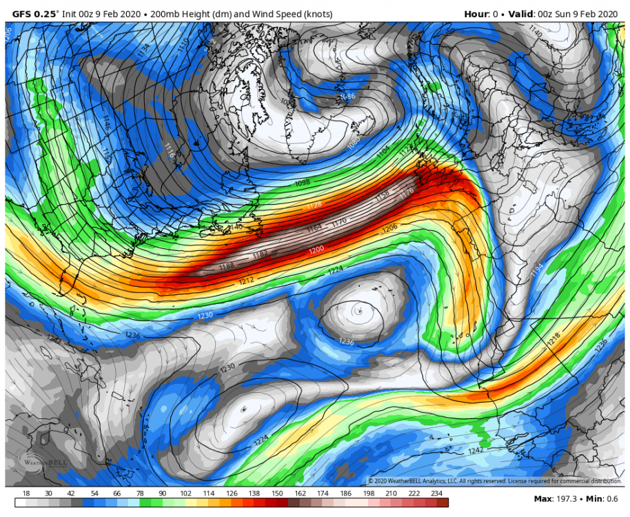
That is nuts. I didn't realize at first it was a 747, I figured it was one of the newer models. I guess that's what happens when you can ride a 170kt+ jet streak 3/4 the way across the North Atlantic.
-
Speaking of wind, who needs to bring back the Concorde when you can just utilize the benefits of the hyper positive NAO/AO and strong PV?
https://www.cnn.com/travel/article/british-airways-fast-flight-scli-intl-gbr/index.html
-
1 minute ago, Blizzard of 93 said:
Do you think that the LSV has any chance at wet snow this evening with the band of precip that is running near the turnpike? The dew points are in the mid 20’s, & It looks like western PA is getting light snow with temps in the mid 30’s.
Possibly, I have a decent burst of snow falling right now with the band of good echoes overhead. My surface temps are above freezing so nothing's really accumulating. You might see some flakes mix in but surface temps are running a few degrees warmer over there so it may start as light rain.
-
1 hour ago, Blizzard of 93 said:
Yes, it sure does. Maybe for once it can lead the way on a good trend back to the better solutions from earlier this weekend.
Go USA !

Kinda suspect of the southern part of that snow zone. GFS is really showing some disjointed action going on there. Not sure if it's the p-type algorithm or what but I've noticed stuff like that from the GFS on the last system as well. It is presenting the best track attm so there probably would be a start as frozen as it just barely slides under PA. There's not a lot of ensemble support for snowfall from the GFS or Euro on this system, especially at MDT.
Additionally, I think the northern folks in here might have more of a snow event to deal with overnight into tomorrow than what's really been discussed. Precip just arriving here is in the form of flurries. I think models are being a bit optimistic with warming, especially in the north central region (Clearfield to IPT, perhaps down to UNV depending on precip coverage). Could be a 2-3 incher. Hopefully Nut has an extra day off and is still up north bc he'll probably see another snowfall.
-
1
-
-
0.6" of new snowfall from the patchy snow area that moved thru this evening.
-
1
-
-
15 minutes ago, Bubbler86 said:
18Z NAM would be disappointing in the next few panels after 84. On the flip side that WAA snow keeps creeping further and further south in PA Sunday night.
Meh, not necessarily. Extrapolating the NAM beyond 84hr is a dangerous game to play, leave that to whoever did that in the other subforum this morning lol. I'll start watching what it does when something gets within it's range with regards to where it's at within the model suite. Within about 48hrs is when I'll start taking it more seriously as it typically is better on the finer details (on the mesoscale) with the thermal column and stuff like that.
-
3 hours ago, Blizzard of 93 said:
What are your thoughts on the winter storm chance that we might have around Thursday?
It appears we have a system to watch. The GFS/CMC/Euro paint a pretty good picture of the multiple ways this thing could go. GFS couples a decent high to the north with a low sliding to the south of PA for a change and a good majority of the subforum sees a decent snow event. The CMC has similar timing/track but a stronger surface high and a lighter event for mainly the southern tier while the euro hangs back the high pressure and the storm cuts. Significant difference maker on the Euro appears to be lack of 500mb low east of Hudson Bay. This feature was present on the GFS/Canadian and it provided a confluent flow to the north aiding the storm tracking underneath us. Without that on the Euro the shortwave just boots out NE into the midwest and the developing storm easily cuts.
-
9 minutes ago, canderson said:
Save for some March random storm I’m pretty confident Harrisburg is set to have the worst snowfall in the past 100 or whatever years. February looks toast at the moment.
Nah not even the worst this century, I think MDT finally got it's measurable of the season during this week of February back in 2007.
-
2 hours ago, 2001kx said:
Had to make a trip to Johnstown today.
Went went down Dishong mtn road and what a scary ride.
Had to be 6-10 inches up there.
Oh wow that road would've been a mess. The short range guidance was pretty good at hitting that west central region between Pittsburgh and the eastern Laurel's with near warning or low end warning amounts, so I'm not surprised that it ended up being a pretty decent event up there.. as I mentioned earlier yesterday. CTP went into the overnight last night without even an advisory for Cambria/Somerset before finally having one in the morning. I'd imagine Clearfield did pretty decently too. I'm only up to 1.7" for the day with still some lingering snow showers around. I measured about 4.5" at the top of Wopsy mountain 4 miles away from here earlier this afternoon and there was also freezing rain on the trees too prior to the snowfall up there.
1 hour ago, pasnownut said:7” at cabin. 10” on the ground.
Get the sleds out!
-
1 minute ago, wolfie09 said:
Make sure your attachments aren't full..
My photos are usually to large as well, so I screenshot the photo and crop it lol Works most of the time..
I've discovered when putting on photos with my phone it will give you the option of small, medium, large, and actual size... and selecting even medium or large will drastically reduce the filesize of the image. The quality is less if you zoom in on it or something, but I know it's annoying trying to decide which old pictures to clear out of the attachments bc if you delete a past pic it will also take it out of the post you put it in.
-
 2
2
-
-
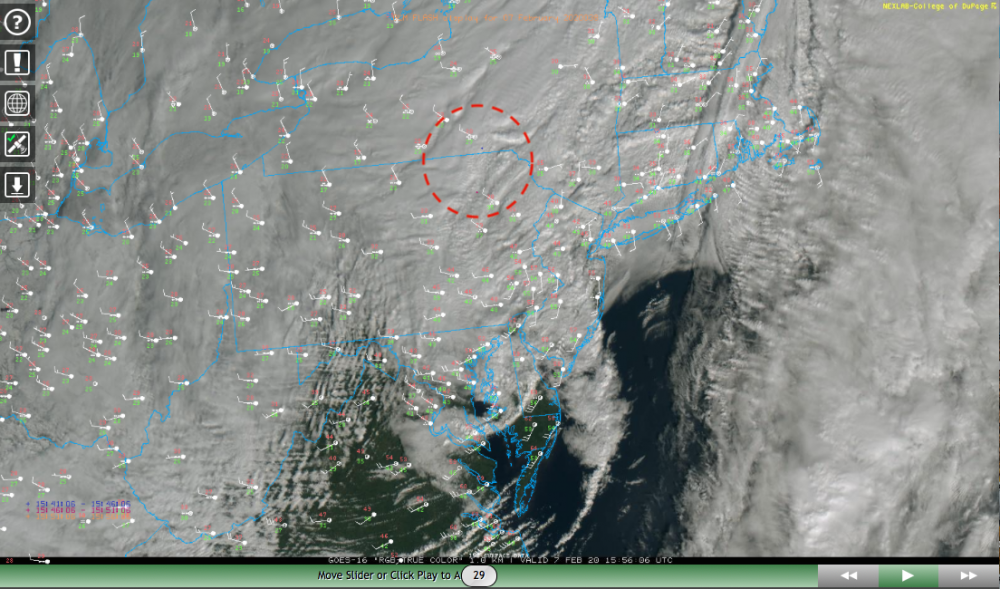
1 hour ago, TugHillMatt said:
Hmmm..Binghamton's current Obs: (Any of you Bing guys witness it?)
Binghamton Regional Airport NY

Thunderstorm in Vicinity Heavy Snow Freezing Fog
Was looking at the GOES imagery.. the College of Dupage site has an overlay for lightning strikes. It looks like it picked up a strike SE of KBGM around 1556z (1056am) along with another one around the same timeframe in NE PA.
-
1
-
2
-
-
I'm glad you guys managed what looks to be a general solid advisory event today over there. I got 1.4" on the day so far over here and might score some additional depending on how much of the backlash snows make it off the Laurels this afternoon.
-
1
-
-
41 minutes ago, Voyager said:
Most of the morning was quiet wind-wise, but I was just outside and noticed a west-northwest breeze picking up, so things must be changing. Not expecting much, but I wonder how long before the flakes fly. Looking at my phone radar, it appears that snow is mixing in as close as I-81 as I type this.
That low pressure center was traversing southeastern PA just about right over your head this morning and via mesoanalysis is centered roughly northern NJ under 976mb currently.
Measured 1.4" of snowfall this morning before the main precip with the deepening low moved away. There's more on this side of town (west side at the foot of the Laurels) than other parts of town. The backlash snows on the WNW flow from western PA are starting to try to move off the Allegheny front now so will see if we can get some additional. My guess is most of that probably doesn't make it east of I-99 this afternoon (downsloping).
-
1
-
-
12 hours ago, Wmsptwx said:
I’m hoping a storm this strong will surprise with dynamics.
I'd say with the snow in western PA and the tornado warnings just next door in northern MD this morning we got our dynamics haha. And this squall line is coming up into York and Lancaster counties with a severe warning.
-
Dumping snow right now, hope I can hang onto this for awhile. Working on an inch or so, roads caved.
-
Just woke up not too long ago and we're flipped over to heavy snow. Have a coating and roads are starting to slush.
-
1
-
-
16 minutes ago, Rd9108 said:
Thanks MAG always appreciate a professional's oppinion. Hoping for an overachiever
Me too haha. I hope somebody overachieves... I have a different set of problems to contend with over on this side of the Laurels with this one. Right now I think KPIT at 12.7" is going to keep its lead over the 10.8" I have to date. I only need about 40" more to get to average for the season lol.
-
1
-
-
1 hour ago, Wmsptwx said:
Yeah don’t seem too impressed for AOO to IPT stretch...may be fun for nut up in Tioga.
The AOO-IPT region is going to come down to how quickly we can get things cold enough to changeover and start accumulating.. as surface temps may be slow to cool to a point that allows more efficient accumulations in the lower elevations. We're also pretty close to the surface low as well. Everyone in this portion of the region should see the changeover but it may be an elevational situation with accumulations.. which seems to be where the hi-res guidance is heading. It probably will be a case of T-2" in the valleys of the ridge and valley region, and potentially some advisory amounts in the higher ridges (especially the western ridges closer to the Laurels/Alleghenies). If that low tracks a tad to the east and/or we get a heavy area of precip that provides a rapid changeover and significant rates, the elevational aspect could be remedied to a degree.
-
It's not the most ideal scenario by any means, but the inside track this low is supposed to take through eastern PA should be sufficient enough to keep the Pittsburgh area in some decent precip for a bit after the changeover. I think Pittsburgh metro should manage at least a couple inches but I do believe the best snowfall may reside in a line just east running up the Laurels thru Indiana/Punxy on up into Northern PA. Higher areas around the metro probably do a bit better accumulation wise but the cold air coming in with the developing low moving from VA into eastern PA should provide a pretty clean changeover for everyone. That HRDPS can be a bit too wound up with it's precip rates but the dynamics present offer the opportunity for a period of decent snowfall rates. Placement/coverage of the eventual precip area generated from the deepening low and the track of said low will have to be watched closely to see if this under or overachieves. Both options are on the table in western PA.
-
5
-
-
Looks like NWS Pittsburgh's whole region under an advisory as well as the north central in CTP's. Pretty surprised they don't have the Laurel's counties (Cambria and Somerset) included.
Quote.NEAR TERM /UNTIL 6 AM FRIDAY MORNING/... Rain is overspreading the area again from W/SW to E/NE and colder air is not far away. Still some low to mid 30s reading across the northern tier. Blend of hi-res output gives changeover to freezing rain as boundary layer cools first across the NW this evening, and this spreads east and south to cover a large area mainly north of I-80 through the pre dawn hours. Cold air becomes established enough over the NW by that time to changeover to snow, and expect a few to several inches to accumulate across the northern half of central PA as well as the Laurel Highlands. Timing is problematic as the Friday morning commute will be negatively impacted with one inch per hour rates as the changeover marches eastward from dawn through mid morning. The lower levels are initially mild and that will cut down on accums for areas of the Central Mountains, but farther north and east, it appears several inches are likely. 50th percentile amounts of 4-6" are supported north of I-80 with locally 7"+ (75th percentile) not a far stretch for Tioga/N Lycoming and Sullivan Counties. Advisories issued for slightly less than the northern half of central PA for combo of glaze of freezing rain and a few to several inches of snow, while sub advisory snow amounts no icing expected central and south central areas, and plain rain for the most part over the far Lower Susq.
-
2 hours ago, Wmsptwx said:
Storm looks ridiculously strong at least.
For sure, everything's taking a low-mid 970s low through southeastern PA enroute to heading down into the 960s going through New England. Unfortunately, it still looks like the storm track is too far inside for the Lower Sus Valley to get an appreciable changeover. This could be interesting for west-central PA (Laurel's region) up into northern PA with the Pittsburgh region also perhaps seeing up to a few inches of snow and the AOO-UNV-IPT corridor seeing that potential as well depending on the timing of of the changeover and track of the low. I wouldn't be surprised if a stripe of warning totals ends up running up the Laurel's where elevation (temps) will aid snow ratios some.


Central PA - February 2020
in Upstate New York/Pennsylvania
Posted
Snowing now, steady light to moderate. Surface temps still need work (mid to upper 30s per mesowest obs).