

MAG5035
-
Posts
5,718 -
Joined
-
Last visited
Content Type
Profiles
Blogs
Forums
American Weather
Media Demo
Store
Gallery
Posts posted by MAG5035
-
-
1 hour ago, Voyager said:
The Delaware Water Gap along I-80 right now...
(not my photo)
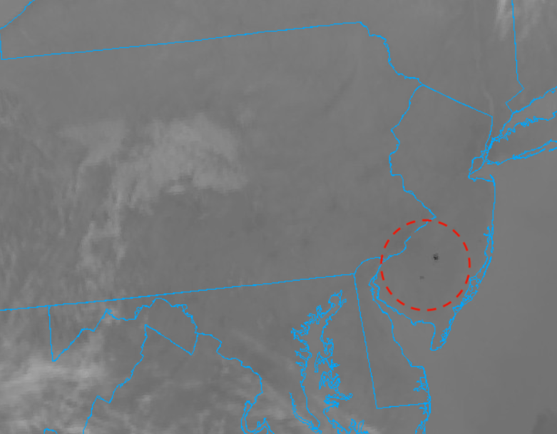
Oh wow, I was trying to see if it was showing up on satellite but couldn't see much in that area. What I did see on the satellite loop just before dark (around 5-6pm) was what looked like a couple brush fires in south central NJ.
Visible (smoke plumes circled)
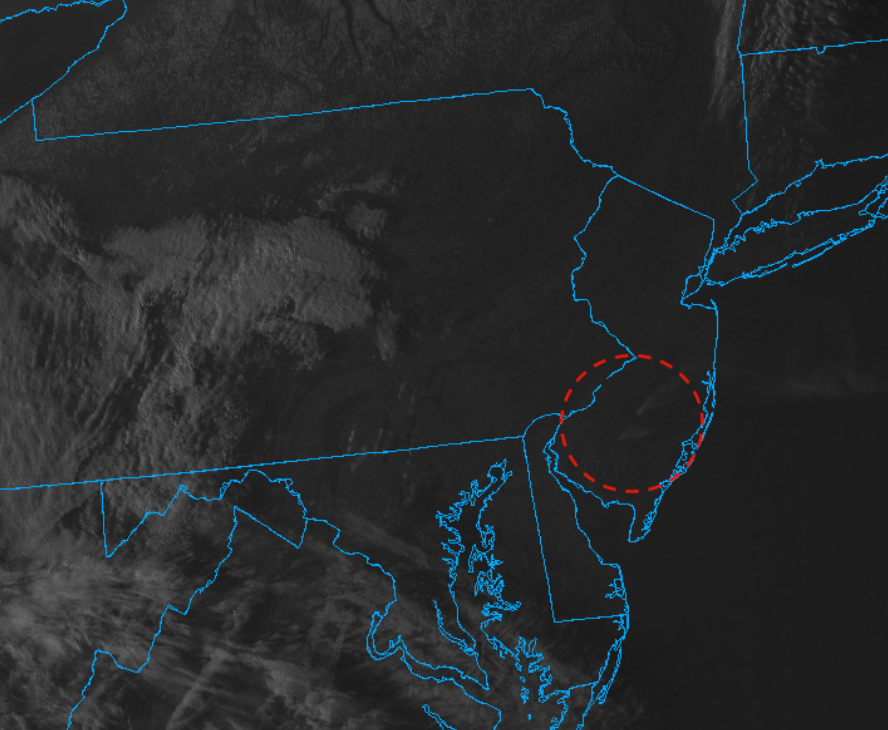
shortwave IR (hot spots circled)
-
Holy crap it’s nice out today.
-
5 hours ago, Itstrainingtime said:
Yep, I meant to say that and forgot. Thanks for participating. I find it interesting that you went 100% on measurable...that would normally seem safe and you'll forget more than I ever know, but looking at all the indices going forward it just looks awful.
Well I'll probably have the measurable covered by Thur/Fri when I get the usual BS coating to half an inch of LES/upslope behind that system whether it cuts or not. You only need 0.1" to qualify as "measurable" lol. My 30% chance of more than 3" can either illustrate a low likelihood given the pattern to see an event that delivers 3"+ and/or not enough cutters and backlash snow showers to get to 3 inches the rest of the winter.
-
33 minutes ago, Bubbler86 said:
Those charts they keep putting out are true met season only so they end next Saturday. Not sure it matters and we can count anything we want. A lot of stuff online is actually yearly totals of Jan 1 through Dec 31. Will be interesting to see if they make a final standing post next Sunday.
They tally snow for any given season up til June 30/31, and then from July 1 onward will count toward the next winter (20-21 in the present case). Obviously it's extremely unlikely to snow from late spring to early fall (although some PA sites have had measurable snow recorded in every month) but that's how the season snowfall charts that CTP has on their site for IPT, UNV, MDT, etc are. Otherwise your tallying snowfall from two different winters going Jan 1-Dec 31, which isn't particularly useful info when winters can vary wildly year to year.
But yea, right now they're talking the meteorological winter months with snowfall records (DJF). There's 4 seasons so it's just divided evenly for each season (3 months per season). There's meteorological winter and there's also astronomical winter, which ranges from the winter solstice to the spring equinox (Dec 21-22 to March 21-22). At any rate, by the time we get to the beginning of April or whenever the pattern busts out into full fledged spring.. CTP will likely address whatever the totals are vs the records for the whole snow season.
-
3 hours ago, Itstrainingtime said:
Since we have nothing to talk about other than home heating ideas, how do we feel about realistic chances for snow before we call this godawful season finished once and for all?
For my yard I'm going to guess I have a 25% chance of measurable snow, and a 10% chance of more than 3".
Other guesses?
If we're talking IMBY's I'm going with 100%/30% here.
-
It is very dry today with RH values in the 10-20% range. Even some obs with below zero dewpoints (KMUI has 52º/-1º currently). PA forestry was reporting fine fuels still have some moisture or else CTP probably would have had fire weather products out per their AFD. I'd say tonight would probably be a good star gazing night.

-
10 hours ago, Bubbler86 said:
I can jive with most of what you are suggesting except the boundary lines. I am not going to go back and look at all the systems from last year but the boundary was very near us much of last year as it has been this year and constantly cutters pushed the 540/850 line well north of us as we had snow to ice to rain situations. Its the lack of deep cold air that has made such a large difference this year. We can say it is AO related but I still have an issue in the way the models are handling it. I feel they were much less likely (except the FV3) to show things cutting under us last year....they were usually showing cutters in the 7-10 day range and that is what happened. This year the models, including the EC, keep trying to start out with Gulf storms or bowling balls that do go under us only to switch back once they hit that magical 7-8 day mark. So something else I/we are missing in my opinion.
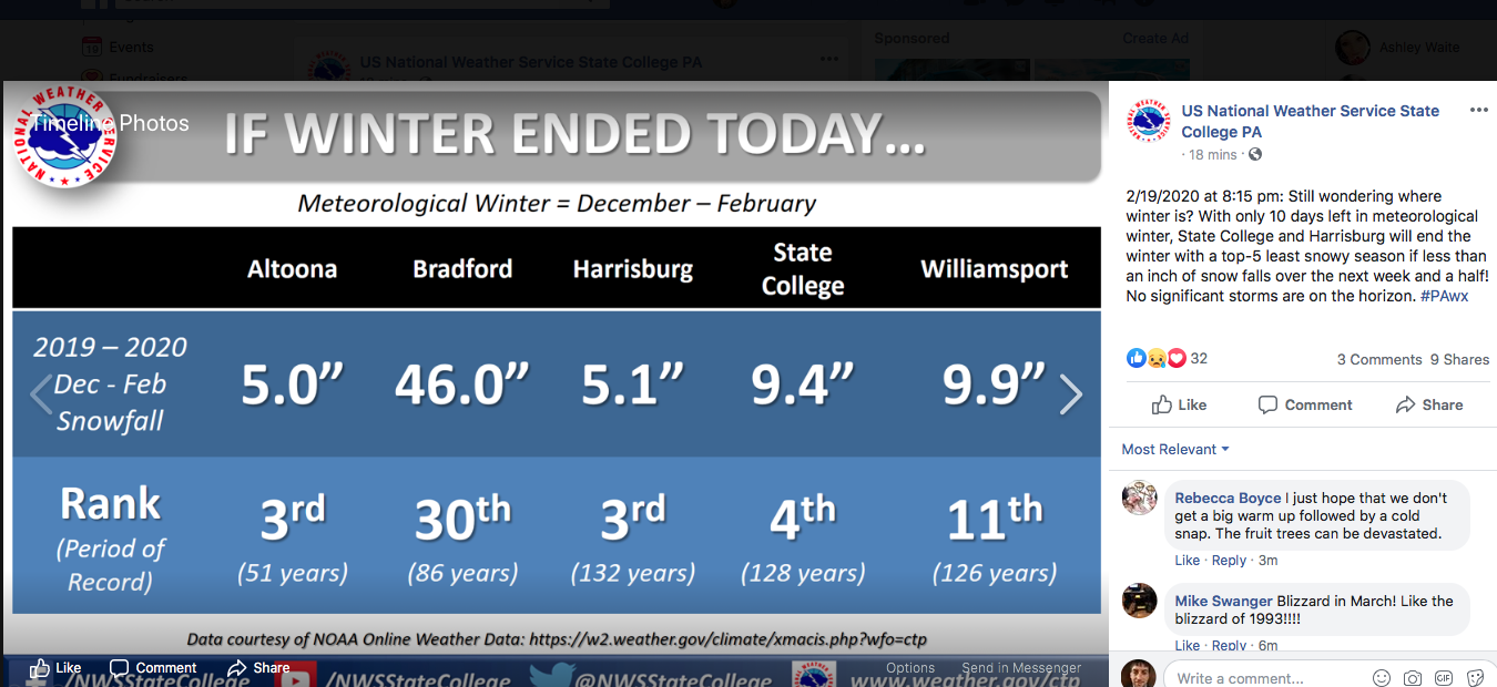
Yea we had several mix events last winter too but we certainly had more that tracked under us as well and most of us scored that mid November snowstorm. We all had a pretty good winter overall last year minus the break it took in December and the first part of January. This winter hasn't even been in the same area code since early Jan. We ran a negative AO in late Jan and most of Feb last year and this year we've run a strongly positive AO with spikes of near record + anomalies in Jan/Feb. That's a huge difference upstairs. Folks like Cashtown had about 50" last winter and MDT had an above average season and this year they're looking at a top 5 least snowy meteorological winter if the 2/27 event doesn't deliver anything there. I've lived here my whole almost 34 years and this one's easily going to be the worst winter I've personally seen unless something big happens late.
At any rate, yes it's definitely the lack of deep cold air thats a major part of the difference this year. You have a remarkably consistent and strong PV that locks up the arctic air (+AO) among having some combination of unfavorable MJO phases, +EPO, -PNA and it's pretty clear to see why we've had a horrendous storm track to deal with. Storms like to ride that baroclinic boundary between the warm and cold air and we haven't been on the right end of that. And we've had occasional opportunities, but we've just missed out on them. As for the models handling things, I really haven't personally felt they've been any more horrendous than usual in the mid-long range. There's always digital snow to be chased in the long range. But otherwise, I know I've seen enough cutters at all ranges of the models and in reality to last the rest of the decade this winter. I think there's been some instances of the models trying to change the pattern to a more favorable one in the longer range and thus throwing out storms that are favorable for us only to revert back toward the base pattern we've been in most of the winter.. but we've also had pretty good stretches of them showing (correctly) about as much digital snow as real snow (not very much). Also, that Carolina's/SE VA event got lost a little bit in the mid range but was generally seen on the models pretty far out. You put a Euro D10 snowmap of that on back on the 13th... reality had the swath north of that but the prospect of SE snow was seen well in advance.
We're now seeing the another event that has been showing up in the progs the last few days around the 27th. A very robust 500mb low undercutting higher heights that are forecast to temporarily build over Canada with also what looks to be a shortwave dropping in from Canada and phasing to make a significant system. This overall 500mb setup looks good for a strong storm system that could develop a heavy swath of snow, but the problem right now on the progs is the alignment looks to be a bit west of where we'd want it. The ridge axis in the west is being progged along the coast instead of over C-PA preferred Idaho. We could be in better business if we can progress this east enough to pop the low on the coast. The 0z GFS/Euro run this surface low up through central/western PA, while the Canadian was a bit better for true central having the developing low running up the coastal plain.
-
 1
1
-
-
Ouch, even H-burg has KAOO by 0.1". The only reason I have 13.9" is bc I live at the foot of the Laurel's and can score some of the upslope and LES scraps. KAOO is about 15-20mi SE of the actual city. I still have to just about double that 13.9" just to match any recent junk winter (01-02, 11-12, and 15-16 with or without the big storm) Good chance we take these numbers into March but that system near the 27th-28th has shown some potential to be something, at least for some portion of the region.

-
1
-
-
4 hours ago, pasnownut said:
Yeah....thats for sure. When you are lacking a 120-160 deg fetch off the lakes, and you are too far south in latitude to avoid being cut....yeah its ugly for them as well. They have had more than a handful of events (and were snowmobiling in the laurels over the last 2 weeks....but they like most south of 80 cant hold in this pattern.
This year has had it's obvious flaws with the storm track and for the most part the Laurel's region have been dealing with the same issues as the rest of central PA. That huge coastal a couple weeks ago did deliver them a pretty good event, but yea we haven't had a northern branch regime.. like at all. I can't think of a single clipper that's gotten anywhere near our latitude all winter.. which ties into the lack of established cold and the dominant +AO and the very strong PV. That definitely puts a dent in potential snowfall not only there but in the upslope areas further down in the Mid-Atlantic Apps.
This year is a pretty extreme case, but the Laurel's haven't had an especially snowy winter for their standards for several years it seems. Even back in 14-15 when we were in the freezer, the dominant pattern that year with the very negative EPO/++PNA countering a +NAO/AO (not the magnitude of this year) meant more of a prominent westerly or southwesterly flow.. which sent the prolific LES up into western NY and the Tug Hill. We have had a lack of established downstream blocking via the NAO region over the last several winters, which combined with a western ridge, typically sets up the NW flow (290º-320ºish) that aims LES enhanced upslope snows into that region.
-
3 hours ago, Bubbler86 said:
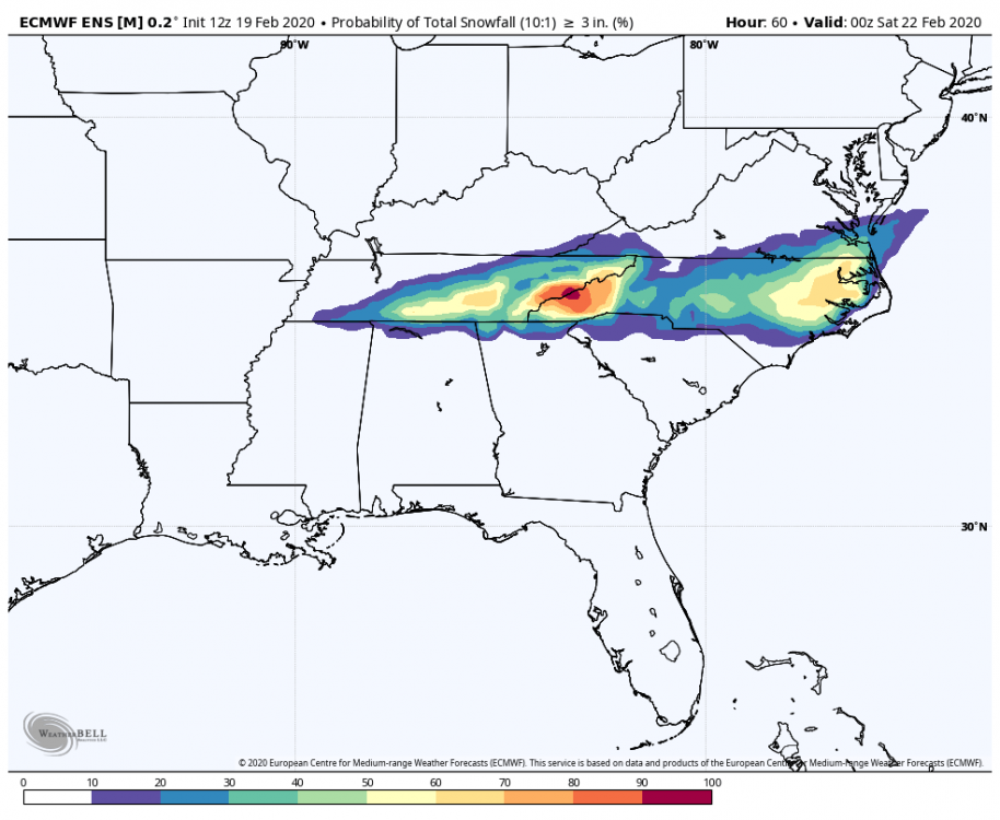
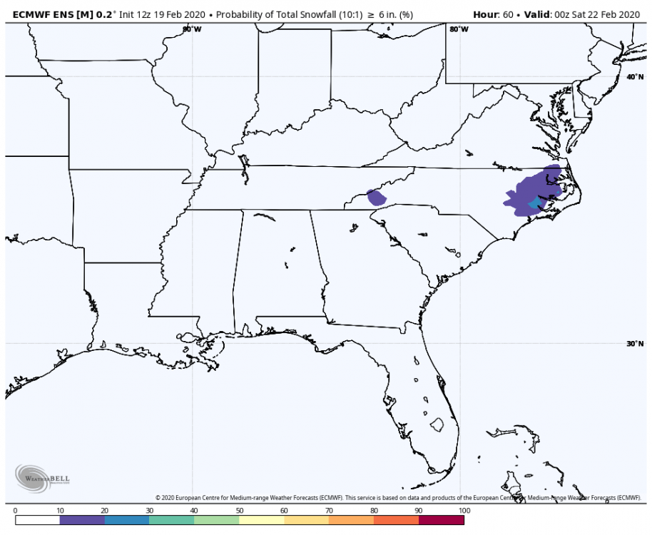
Completely off topic of this forum but I noticed some discussion in the MA concerning how the Euro was not overly amped for NC and VA a few days ago, while the Nam was, and whether the Euro caved to the NAM in changing its tune. I am of the opinion that the Euro caved. Nothing has happened yet and it could all fall apart but the latest Euro snowfall map is so very Nam like (from days ago) minus the over exuberance the Nam puts into its totals from time to time. I am a self professed backer of the Nam so I am going to toot the horn. These are 10-1 totals and that may not be reality especially on hard surfaces. The bottom map is the Euro from 48 hours ago as a compare to the top map of today's 12Z Euro.
I think the NAM is a little too wound up on the Southeast slider. The Euro did finally come on board from being on the non snowy end but certainly not the magnitude of the NAM, which is showing a pretty big swath of 6+ with imbedded double digits. The 12z Euro, with support of it's ensembles is showing more of a general 3-6" type snowfall from TN to Eastern NC sans the OBX. The 12z GFS/GEFS looked to be the least snowy (18z GFS coming in a lot more robust than 12z showing more TN swath and bigger totals in Eastern NC). The biggest consensus on decent snow falls on eastern NC and SE VA just below DT land.
So looking at things, the NAM is a big outlier on it's significant totals right now. Where it does have some support from the Euro though, is a more robust snow swath starting all the way back through a significant portion of TN. Other models don't get much going until the piedmont region east of the Apps, so that would be something to watch (18z GFS noted). I think a general 2-5" event running an axis of I-40 in TN from just east of Nashville to eastern NC is pretty reasonable, with the potential for a couple 6-7"s in eastern NC... which is still a bigger event than i've seen here all winter lol.
Good opportunity to illustrate my post the other day about the posting of the ensemble snow probs using the whole forecast length. This is a much more useful utilization of these products. Notice the Euro ensemble shows good probs of 3"+ but very limited on 6"+. I consider this a good compromise of the overall model suite right now between the very snowy 12/18z NAM , the less snowy 12z GFS/GEFS/CMC ensemble and the somewhat less snowy 12z CMC (not a lot of TN snow but similar amounts to the Euro in eastern NC).
-
1 hour ago, pasnownut said:
As I like looking at 500 maps (and as Daxx suggested earlier), Looks like next 10 days is much the same and from that period on, the PAC/PNA seems to get better flow to it which may end the cutterfest we've been enduring. Only worry, is that its 10 days away.
IF we could get something to trail the cutter that digs this trough in the east, it could lead to some fun round here.
The ops all have some kind of a wave that seems to take an okay track near the 25th today, esp on the Euro and GFS and some semblance of it on the GEFS. Problem is marginal cold again. We get another half decent dose of cold with a strong high that drops down later this week (probably squashes the system after tonight's too) but it's quickly routed and cut off again from us for the potential arrival of the aforementioned 25th system.
Just hasn't been there at the lower levels, and it's been that way all winter.. despite it not really being an outright torch for a good part of it. I've noticed on model forecasts that 1000-500 thicknesses that can usually get the job done, aren't. Take that Feb 25th system progged on the GFS for an example. We're getting late but not THAT late in the season yet, so we can typically do marginal setups somewhat above the magic 540 number, especially with the track the GFS has under PA with the 546 line staying mostly at the mason-dixon line and a low transfer. That should be a straight up light to moderate all snow event for at least everyone above the turnpike in here. The 500mb checks out okay with an undercutting look and high heights , and that's around the timeframe the EPO is supposed to be flipping negative. But theres no cold air in Canada (relative to average for them) and the cold air that is available dumps into the western US trough.
I definitely think the EPO is a big influence, but I still think the +AO could mitigate what it could do if it went negative. I don't feel a run of the mill -EPO is going to counter a continued +2 to +3 AO that the progs are showing enough to matter here. We need to neutralize the AO. I think a reversal is coming eventually with the seasonal slowing of the jet. But with how anomalously strong that and the PV have been all year, how long is that major shift upstairs going to take?
-
3
-
-
16 minutes ago, pasnownut said:
speaking of anomalous, didnt Somerset get 40 some" a couple Marches ago. I can remember snowmobilers complaining about not being able to get into parking lots and not having it goomed....or something along those lines.
I don't recall anything that crazy in the last few years, although the March 2018 storm delivered some 20+ in the southern Laurels.
-
1 hour ago, Itstrainingtime said:
100% correct buddy! Both storms were historic and one of a kind for sure - as an enthusiast and after some reflection I'd rate 1982 higher for one reason...how often is it 25 degrees midday on April 6th? The snow/wind/temp trio produced epic drifting for any month let alone April. I was a junior in high school and remember going outside in the middle of the day thinking to myself that it had the look of early January. It was incredible stuff!
I often wonder which is more anomalous...and I'd love to get @MAG5035 thoughts on this - is getting 5.5" of snow in Lancaster a bigger deal on October 29th or getting 9" of snow on April 6th? I think about that kind of stuff a lot.
")
It's kind of a toss up. If you look at it from a sun angle perspective with getting it to accumulate your over a month past the fall equinox on Oct 29th and 2 weeks past the Spring equinox April 6. The sun on October 29th is just about where it would be right now, so it's definitely harder for accums on the ground. But in terms of air masses your probably talking similar probabilities of having a setup with sufficient cold air available.
13 minutes ago, pasnownut said:earliest I've seen was Oct 14 back in 85-86 i think. I was up in Tioga w/ my brother as we were grouse hunting, and it was so so wet. By the end of the hunt....so were we.
Earliest I've seen is Oct 2, 2011 at elevation on the top of the Allegheny front up from where I live and the latest was May 11, 2010 and May 12, 2008.
-
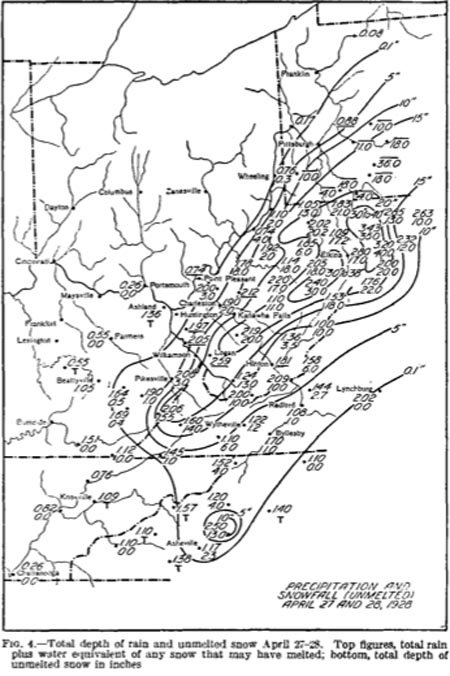
I'm not sure what it did in the LSV, but if you guys want an anomalous event try April 27-28th, 1928. Yup, thats a 36" near Somerset, PA.
-
2
-
-
55 minutes ago, Blizzard of 93 said:
Great points.
However, I feel that this is a weather forum where maps should able to be posted for people to provide analysis.
Most of us should know not to take a 10 to 15 day map as the absolute truth. They should be used just to spot trends & to look for pattern possibilities.
Yea I agree, i'm definitely not saying one shouldn't post certain maps. Was just giving my own opinion on it. I'll certainly have a look at what the long range snow maps look like but if I'm making a post pertaining to the longer term I rarely will incorporate them simply because they're too variable run to run even if the overall big picture is showing consistency on modeling.
-
5 hours ago, Atomixwx said:
I did lol. In all honesty, the guidance packages shouldn't even publish them. It just seems counterproductive.
Speaking of counterproductive, Im not a fan of those ensemble probability maps for x amount of snow being posted as much (not necessarily in here) as they especially had been a bit earlier in the winter taken out to the full 360/384 hrs. Sure you can make a very general assessment that the pattern looks good or lousy overall over the next 10-15 days, but there's certainly more important things to look for in a given pattern when going out into longer range. Your pretty much in the same boat as you are with long range snowmaps and any kind of specific numbers. I think getting more serious about the probability of x amount of snow type stuff should be reserved for inside of 5 days when reeling in specific threats via global ensemble guidance, IMO.
-
1
-
 2
2
-
-
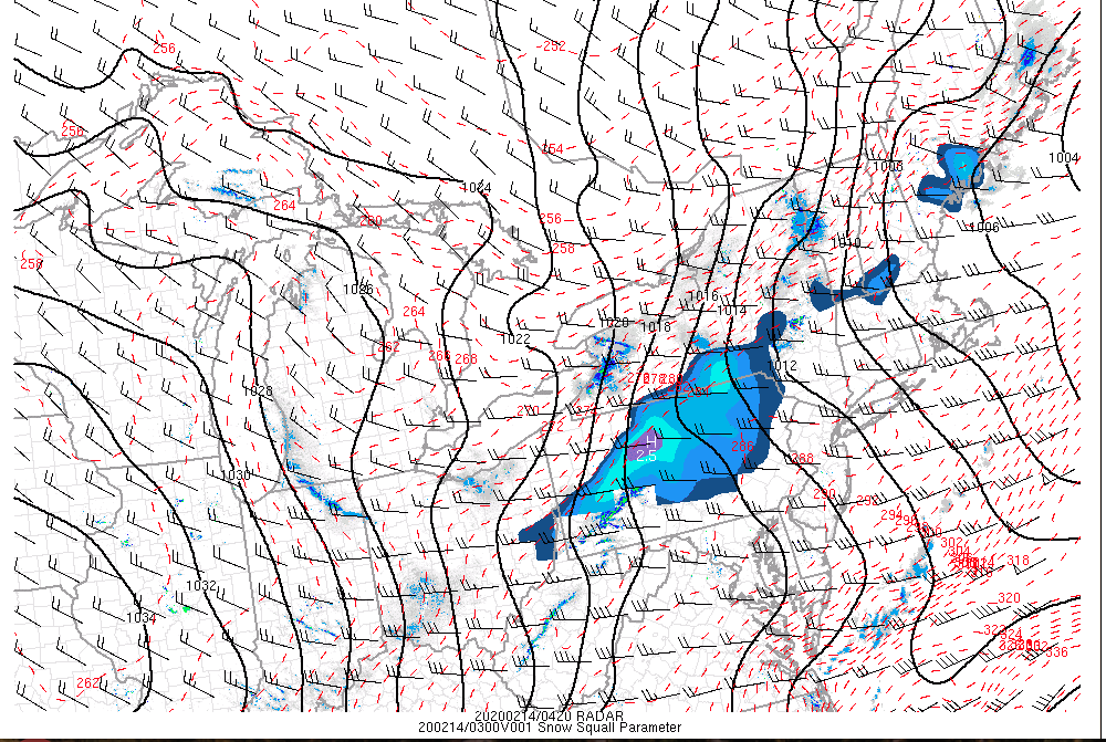
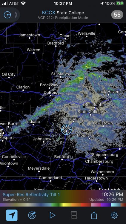
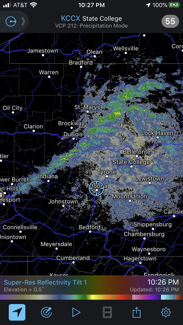
It's a pretty decent snow squall. Streets are caved.
-
34 minutes ago, Voyager said:
And everything out ahead of it is dying out right at the Susquehanna. Wonder if the squall line will as well...
I think the squall line might have some staying power across the state. I bet it makes it to at least Harrisburg with a decent burst of snow, and it may cross the rest of the state. It's being driven by the dynamics of the arctic front and the latest mesoanalysis shows the snow squall parameter product registering pretty good ( latest is lagging by about an hour or so). Some of that ever so slightly stronger Feb sun would've really lit this thing up if it were the daytime.
-
Here comes our one day shot of arctic air.
-
1 hour ago, Bubbler86 said:
We are not in emergency mode or whatever it is called. Free for all.
It's not like it's off topic lol, you guys are just discussing snow chase places whenever that Euro solution probably comes to fruition.
-
4 hours ago, Blizzard of 93 said:
What are your thoughts on the winter “song” changing towards later next week into late February ?
The MJO & ensembles seem to be leaning towards a change, hopefully it will be music to our ears...!
We gotta neutralize the +AO regime up north. Until we see improvement up there I'm going to maintain the opinion of seeing the status quo of us being at a disadvantage when it comes to the storm track and any kind of cold regime that sticks. We were working the back end of a -EPO on the lead up to tonight's system and that influential teleconnection just isn't enough to counter the SE ridge via the +AO/+NAO/-PNA and Phase 5-6 MJO forcing. We wouldn't have had a perfect winter storm by any means with the track tonight's low is taking, but we likely would have seen a decent event with just a typical CAD setup, and a strong enough high to the north may have forced the low to try to reform on the coast.
At any rate, we have the EPO swinging positive now, which will cut off the cold air which was trying to push for a change. Thus, we will have a pretty significant but very short lived shot of arctic cold behind this current system on Friday. Models do try to neutralize the EPO at least for a period of time near the 18th or so, but we maintain solid +AO/NAO. What the 0z Euro op has in the D8-10 range tonight with the AO is insane. It basically left the chart which goes up to +7. The other op and ensemble guidance (don't have 0z Euro ensemble yet) isn't that extreme but still has a spike in the index that is quite anomalous in that timeframe. You can't maintain a cold push to our latitude with such low heights over the polar region. We have to break this regime to have a shot at anything more than some kind of crazy fluke event down the stretch. Which if I'm being honest, the 0z Euro is kind of showing such a thing in that same D8-10 timeframe with an undercutting 500mb low and coastal storm with just barely enough cold available to actually snow in the piedmont region (pretty tight precip area). That can definitely happen there or more easily, here... but I'm talking the big picture in terms of the overall weather pattern.
I'm inclined to think things break down eventually over the pole. It has to at some point , but the big question of course being does it happen in time to do anything other than make a really cold and unsettled first half of spring. Also keep in mind as we get into March that MJO influence changes. Phase 2 and 3 are best correlated to cold in our section of the country in the FMA period. We're too early in the month yet I think to consider that 3 month set.. as i'd probably be using JFM yet until the end of the month. 2 and 3 are still colder leaning JFM, but correlation isn't as strong. If we can set up and start an 8-1-2-3 type pulse by the end of the month, that could be a good thing.. or at least a start. Again, I think the key to our end game is going to be whether or not we neutralize or reverse the dominant +NAO/+AO regime. It's been the big constant since we've kicked the new year off.
-
1
-
-
Let me play you the song of winter 2019/2020, Rain and Pingers.
-
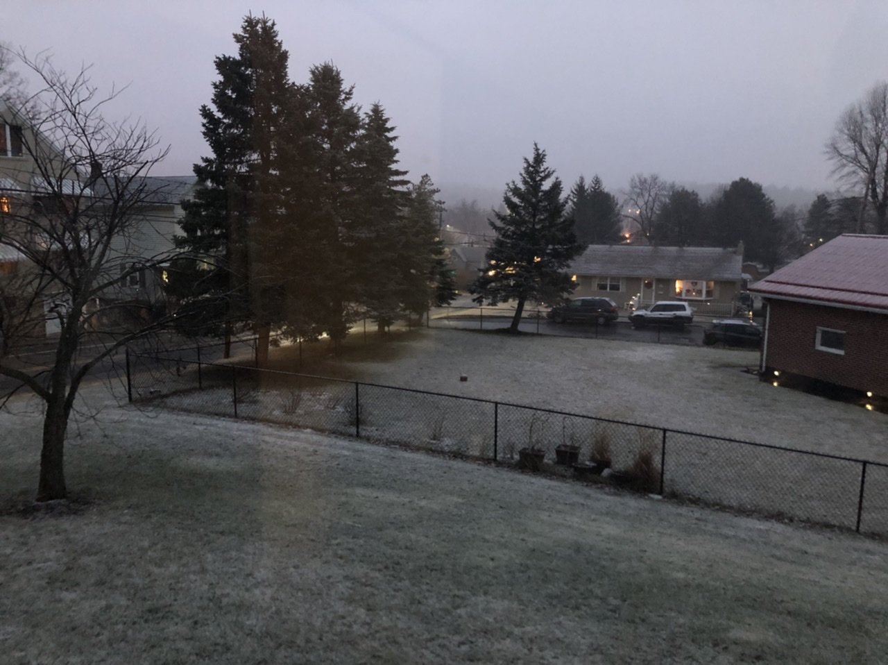
Light to moderate snow, 0.4" on the non paved stuff. 34ºF
-
1
-
-
Well if all else fails I can say I managed to get something on the ground out of this.

-
1
-


Central PA - February 2020
in Upstate New York/Pennsylvania
Posted
I was impressed that the blizzard warning in western NY (both off Erie and Ontario) has like a 42 hour duration. Not sure where exactly everyone resides up there but some seemed mad BUF issued blizzard warnings. I'll take them if they don't want them lol.
For the record I do think the blizzard warnings are warranted given the way this low strengthens and tracks.. and then sits over southern Quebec for a time. Realized the storm had a bit of a March 3-4, 1999 look. That storm had a similar track with blizzard conditions in western NY and PA. Personally I saw a rainstorm turn to snow late evening and got woke up in the middle of the night to 40-50+ mph winds and thundersnow. The wind was strong enough to take trees down and knock power out. We only had 4-5 inches but there was a straight 6-8 hour period that was a whiteout. Some Laurel's spots up into western NY got way more snow. One of the only times I've seen legitimate blizzard conditions.
But I digress, our current storm isn't going to be digging down as much as that one did as you can see on the archive maps. So while I think parts of the Laurel's region into northern and NW PA could see several inches of snow and definitely plenty of wind, the low doesn't get wound up until its moving up through eastern PA into NY state (a theme this year whenever we have had an eastern US low develop). The LES potential looks pretty prolific, with the low closing off over southern Quebec and sitting for a while setting up a westerly flow. Probably better LES potential than the comparison storm I put up in some cases, although I probably wouldn't convince the Rochester folks of that since this one is going to have synoptic tracking further west and then the LES setting up on a more westerly flow. There's going to be monster totals especially off of Ontario where the whole unfrozen length will be utilized with that westerly flow. The favored LES areas in western NY probably will have some big totals too. The lakes are completely open for business, and the airmass this storm is ushering in is a pretty cold one.