

MAG5035
-
Posts
5,718 -
Joined
-
Last visited
Content Type
Profiles
Blogs
Forums
American Weather
Media Demo
Store
Gallery
Posts posted by MAG5035
-
-
Safe to say this is probably making it off the mountain tonight, finally. Or in winter terms, miss the big coastal low and get some weenie ULL snows.
-
3 hours ago, Cashtown_Coop said:
Last month Johnstown came in with the least cumulative precipitation in the state (0.96”) which shows how dry it’s been your way. I had 1.17” which wasn’t too far behind but with higher temps, may have been a higher impact
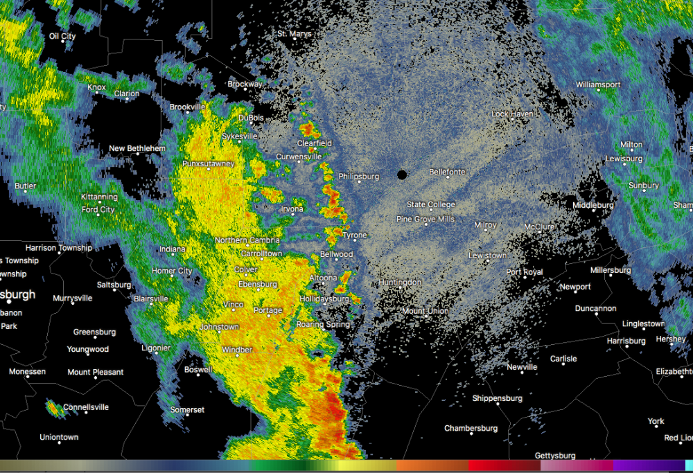
That region of the Laurel's has definitely reversed that trend in the last few days, especially just south of JST in parts of Somerset County as we've had a more favorable setup for pop up afternoon storms. One of the first places they fire on hot/humid days around here is typically along those ridges in the Laurels. The late afternoon storms that triggered a flash flood warning in a portion of Somerset earlier (couple spots of 3-4" on the doppler estimate) were on the heels of the same general area getting a similar blob of slow moving storms and scattered areas of 2-3+ totals on the doppler estimates just the other day.
Meanwhile down here, no dice again this evening. All around and not here. My yard is still in ok-ish shape, but we need hit with something in the next few days.
-
4 hours ago, Voyager said:
We just got another 1.50" of rain today.
I guess from here on out I better shut up about the Tamaqua Split...

I’ve been feeling that struggle the last couple weeks haha. My location has missed out in all directions on all the daily storms... although the blossoming radar up the mountain from here might suggest the weather may have other plans this evening for a change.
-
Lol that storm that's been sitting mostly over Gettysburg is basically thumbing it's nose at @Cashtown_Coop's toasted backyard.. though looks like it's trying to reach there.
-
The interesting thing about this run of hot weather so far is we are achieving widespread 90+ on what has been a generally a pretty solid northerly flow the last few days. The good thing about that is the source region is obviously much drier than a more typical southerly or southwesterly flow would be with drawing the humidity from the south. The result is MDT at 93ºF currently with a 56ºF dew point (29% humidity) and a heat index value of only 91ºF.. for instance. So it's certainly a stretch of hot weather but it definitely could be worse. I suspect humidity will be increasing the next few days as flow reverses, which could help for more thunderstorm chances. We'll still be in the same hot weather regime with similar temps in the 90s, so as humidity goes up we may see some air quality/heat related headlines needed for the urban areas in the Sus Valley.
-
 1
1
-
-
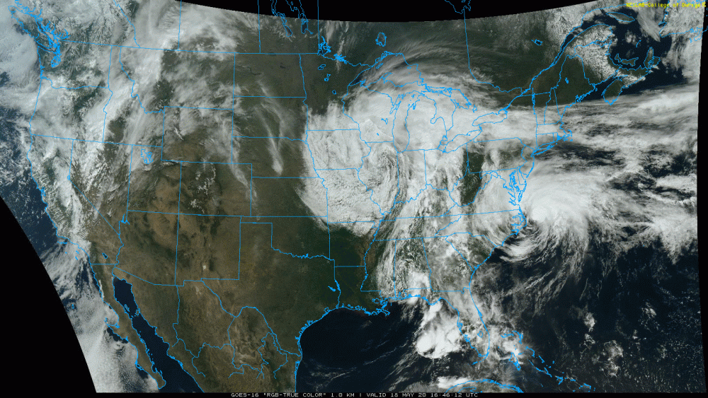
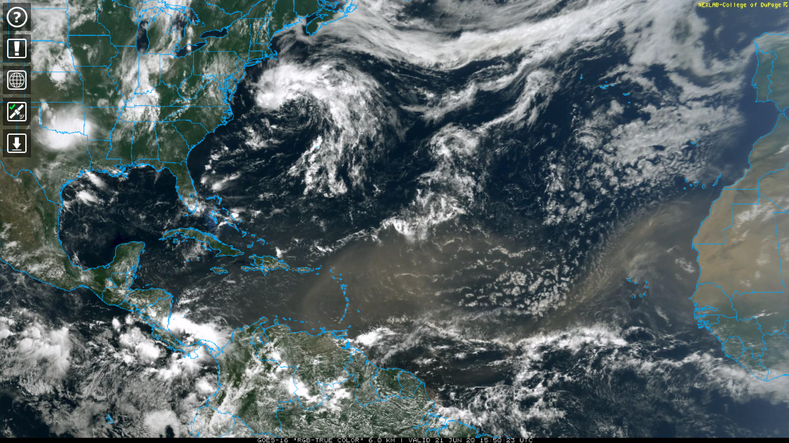
Speaking of dry weather, that Saharan dust that has been all the rage in terms of weather phenomena the last several days is clearly visible on the satellite.

-
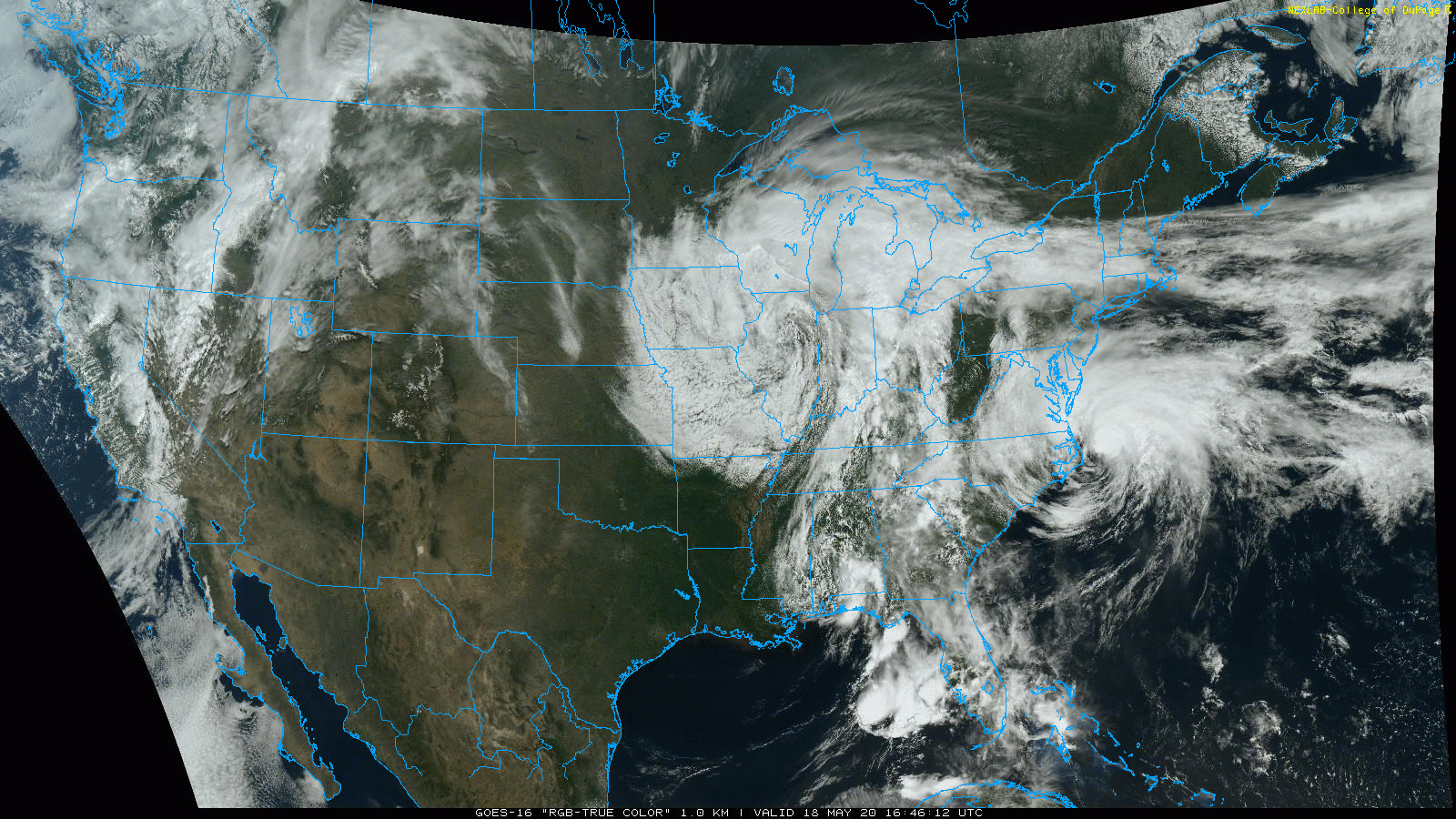
Pretty impressive miss for the local area lol. Arthur sliding east up the coast and out and the cutoff low that is progged to slowly drop down west, and then under us. Quite a satellite presentation. You can even see a bit of another counter-clockwise spin in Southern Alabama.
-
2
-
-
Dang a lot of mid 80s in the Sus Valley this afternoon, what a difference a week makes. Next week looks wet, that potential tropical system off the Florida coast will have to be watched for interaction with the cutoff low that's progged to sit around a good chunk of next week.
-
Lol, mixed rain and snow with this latest shower coming through. Sure is a miserable day trying to finish the lawn.
-
 1
1
-
-
Looking over the stations that CTP gave numbers for record minimum highs on.. MDT at 46ºF beat theirs by two degrees, Altoona by 1 (40ºF), and IPT (46ºF) and Bradford (34ºF) tied their record values. Browsing the Laurel's stations on the mesowest site, JST and a couple of the stations reporting in Cambria/Somerset barely got above freezing... while a few stations in the Laurel Ridge area near Seven Spring's did not go above freezing at all.
What's really amazing about these min/max temps is the fact that it was achieved on a day that had a fair amount of sunshine in between the clouds/snow showers. Just shows how cold the airmass was. And it even ended up that the core of the 500 low and -40º 500mb temps did in fact only swing through upstate New York/southern New England (hat tip to the Euro).
-
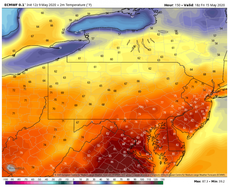
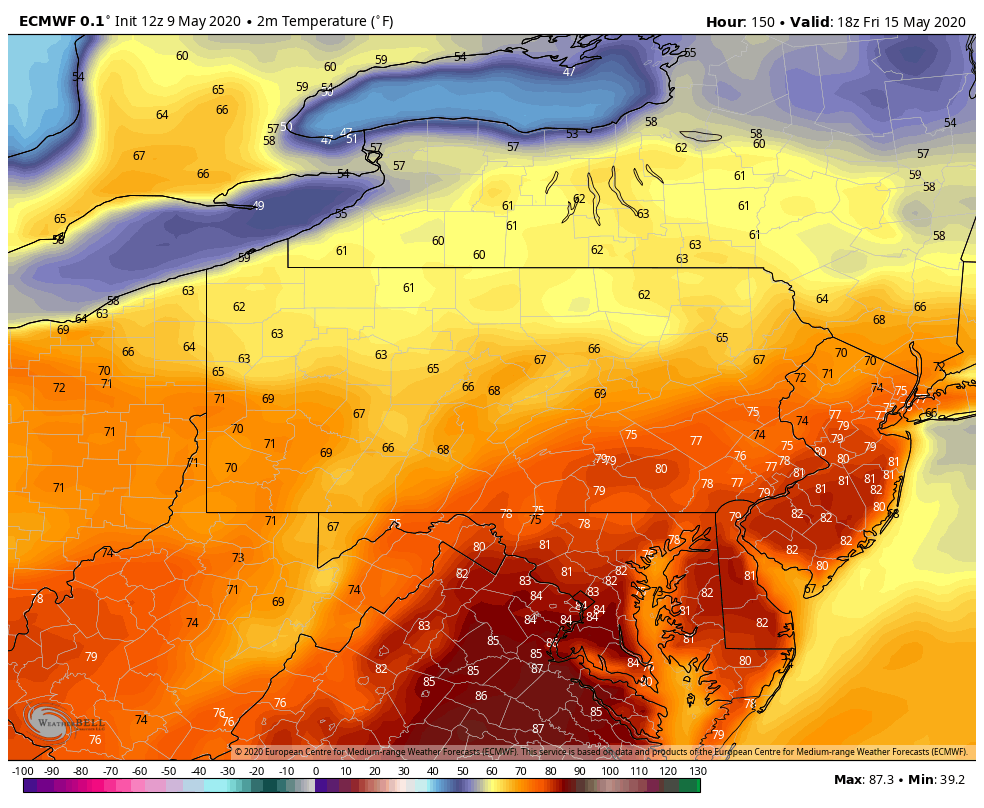
While there's some rain around that could screw this up, this is what we're potentially looking at for highs this coming Friday currently. There's going to be a few more cold nights to get thru the first half of this week though.
-
These heavier squalls moving through the central counties right now are probably going to make it to Harrisburg and deeper into the LSV the next couple hours with the best daytime heating likely maintaining them. Look for them to have grapuel and snow pellets in them as well with the sun heating surface temps into the 40s.
-
1
-
-
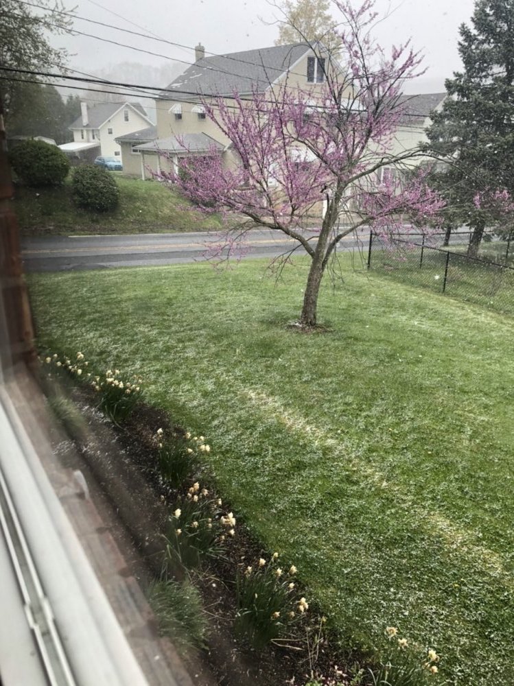
Amazing to see a full fledged snow squall briefly whiten the ground at 1 in the afternoon on May 9th.

-
1
-
-
6 minutes ago, Ericjcrash said:
Its cruel isn't it. I dropped from 39 to 32 almosy literally instantly with the changeover though but I'm way north and at 2000'
Speaking of cruel, the deck and the car tops are already froze over here. That's going to be a long time we're below freezing here (probably 10-12hrs).
-
31 minutes ago, Blizzard of 93 said:
Anyway, how are we looking with the advance of the snow line to the south & east ?
I'd say judging by the radar your currently at your best opportunity to see a mix or changeover with the remaining synoptic precip.
-
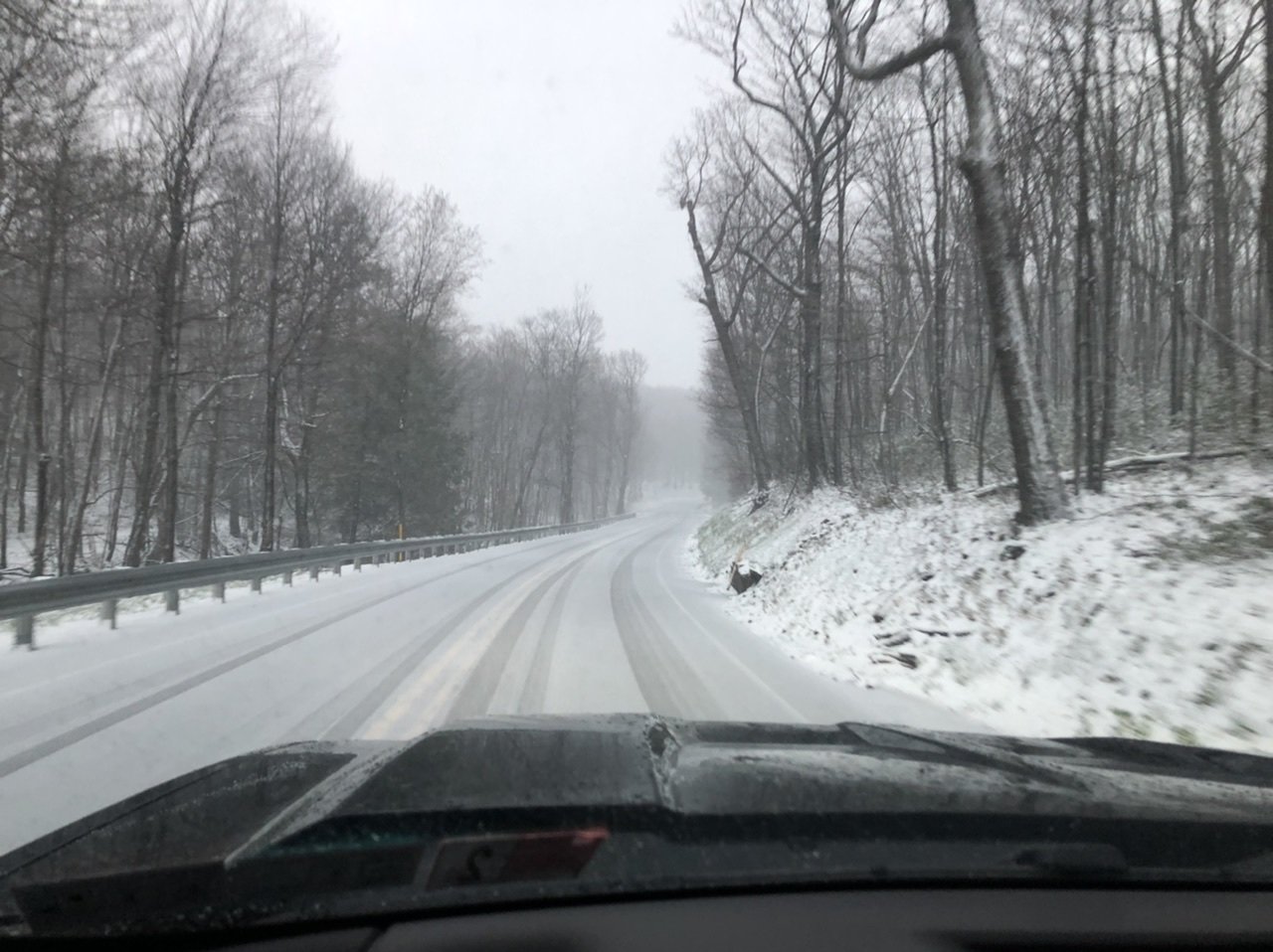
The situation 4 miles away at about 2500’. It’s 29°F up there. Looked like about an inch or so.

-
4
-
-
A steady light to moderate snow driven sideways on a stiff wind, no accumulation. It's definitely a weird sight with the freshly leafed out trees in town here as a backdrop. Temp already back to 35.
-
1 minute ago, Blizzard of 93 said:
Congrats, what do you think of the chances this evening for the LSV?
The 18z 3k NAM still likes the idea of a changeover to snow for most of us by later tonight.
Might see some flakes in parts of the LSV but I think the NW flow drawing the cold into PA and undercutting the back side of the precip shield is going to limit seeing too much east of the mountains because of the downsloping component. Although the surface low getting going on the coast may help a bit keeping some precip around.
-
1 minute ago, Cashtown_Coop said:
Great image there. Is this the gr2 analysts radar ?
Nope this is just the Radarscope app. It's a one time $9.99 app but it's def worth it. It has all the dual pol products, different tilts, shows mPing obs, watch/warning products, etc.
It also has additional subscription tiers now that you can get lightning data, archived and longer radar loops, spc outlooks, and local storm reports on as well. I just have the base one and use it on my phone and laptop.
-
1
-
-
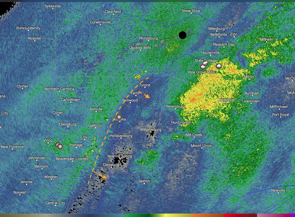
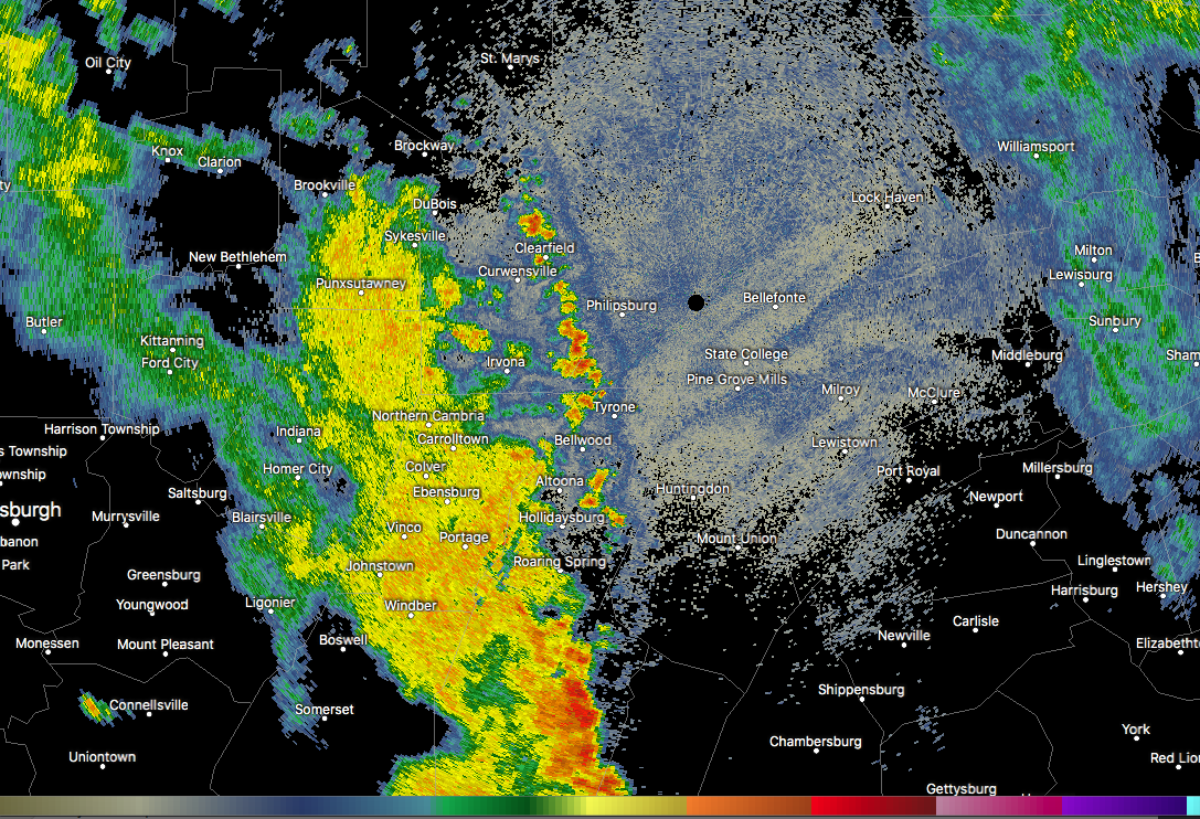
Here's the downslope shadow on the radar, the dashed line is roughly where the Allegheny Front is. The mPing snow report in Altoona is mine. I'll probably eventually make a drive up to the top of the mountain this evening.
-
1
-
 2
2
-
-
5 minutes ago, Bubbler86 said:
Yea, I truly feel bad for the folks out your way that used the Pandemic time to get a head start on their garden and yard stuff. Its not fair really. Even here we may lose a lot of stuff we have worked on but mid 20's is going to hammer stuff out there.
My mom was going to get flowers last weekend and decided not to go that day. I promptly told her she better wait til after Mother's Day.
-
1
-
-
Annd we have flipped to snow here... that quick. It's light though, the downsloping just off the Laurels is evident on the radar.
-
3 minutes ago, Voyager said:
Pretty dramatic change. An hour ago it looked like just rain up there.
Black ice is a definite threat later this evening with the gusty winds and the rapid temp drops, especially in the central counties but everyones probably going under 32 tonight. It's looking to bottom out at 25ºF here, which is really going to hurt sensitive stuff.
-
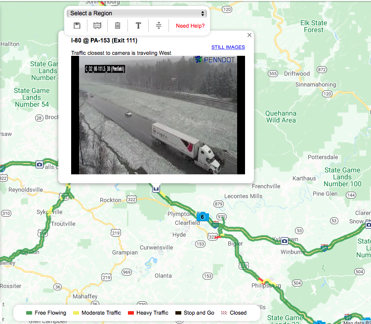
Snow reports on the mPing obs down into Cambria County now, snow on the ground on the 511pa cam on top of the mountain above Clearfield (I-80 Exit 111). That temp drop in western PA is pretty wild to see. Already freezing in Dubois and Pittsburgh metro is in the mid 30s.
Still rain here but the winds have kicked up pretty good so temps are likely to start falling soon.

Central PA Summer 2020: Hoping The Heat Makes a Hasty Retreat
in Upstate New York/Pennsylvania
Posted
Update: I might've spoke too soon. Radar's really breaking up locally with some new stuff that fired east of here and heavier action to the south.