

MAG5035
-
Posts
5,718 -
Joined
-
Last visited
Content Type
Profiles
Blogs
Forums
American Weather
Media Demo
Store
Gallery
Posts posted by MAG5035
-
-
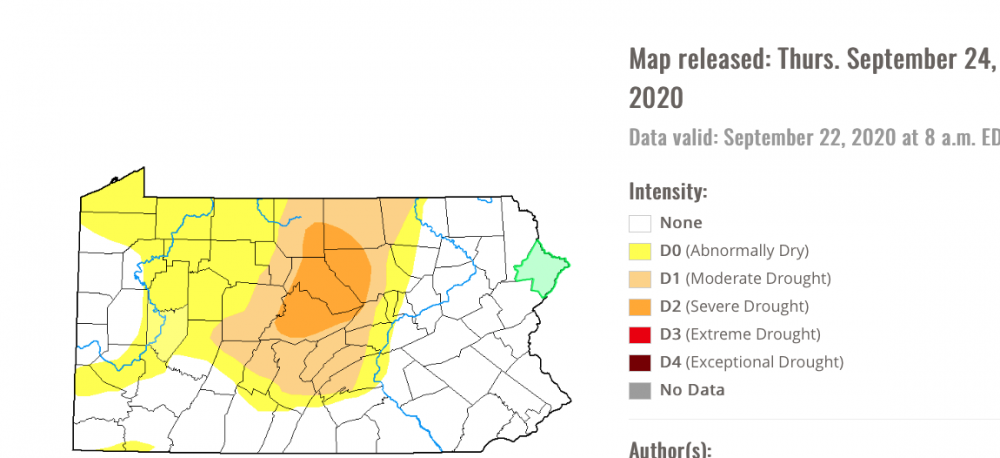
A bit of a sluggish start to things early this morning but a nice rainfall now ongoing. It's actually been quite heavy at times the last hour. Overall, this should hopefully help the worst parts of central PA in terms of the D2 drought bullseye that has popped up in the last couple weeks.
 13 hours ago, canderson said:
Our beloved radar is back online.
Finally, Historic CCX has returned just in time for this rain today. Same can't be said for LWX radar which could be out through October 16th now. Good thing such an extended outage didn't happen in the dead of winter for the Mid-Atlantic gang with a big snow event coming in or during a more active time of the year for severe weather.
QuoteKLWX WSR-88D radar is out of service until on or about October 16. UPDATE 3 Sept 29th 2:50 P.M The KLWX (Sterling, VA) WSR-88D outage, which began on September 20, 2020, will continue and remain out of service until on or about October 16, 2020. On Saturday, technicians from the NWS Radar Operations Center (ROC), based in Norman, Oklahoma, determined that a primary component for turning the radar antenna, the bull-gear, needs replacement. This repair will require 12,000 to 15,000 pounds of equipment and a six-person team from the ROC to restore the radar. At this time, the team anticipates repairs being completed on or about October 16, 2020. During the downtime, adjacent supporting NWS radars include: Dover DE (KDOX), Mt. Holly NJ (KDIX), Pittsburgh PA (KPBZ), State College PA (KCTP), Charleston WV (KRLX), Blacksburg VA (KFCX), and Wakefield VA (KAKQ). For a radar mosaic loop for the region: https://radar.weather.gov/ridge/Conus/northeast.php Further updates about the situation will be issued as information becomes available. Thank you for your understanding during this extended outage. Point of Contact: Christopher Strong email: [email protected] office: 703-996-2223
-
 1
1
-
-
Looks like a light shower fell here at some point this afternoon. Basically the first rainfall of any amount here since September 13th.
-
37 minutes ago, canderson said:
Today’s partly sunny and 81 forecast has given way to heavy clouds, drizzle and 68. Wonder what’s happen8g for these forecasts to bust so badly this week.
Likely the influence of the remnants of Beta and the southerly/southeasterly flow that has persisted. You can see the low level swirl on satellite just off the coast this afternoon and the clouds hanging tough in eastern PA.
38 minutes ago, Itstrainingtime said:After a great day in Annapolis, came home late last night to rain. I was shocked.
It's still raining.
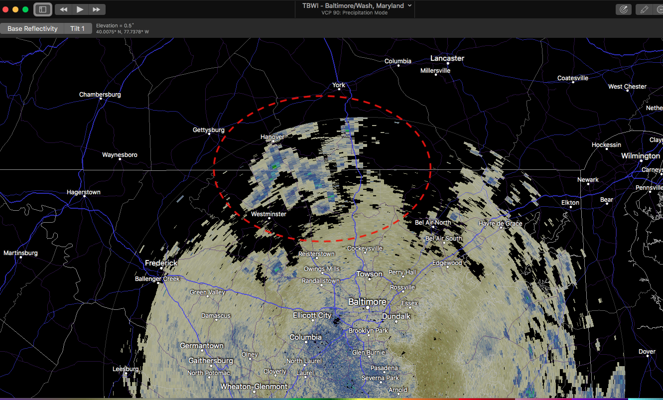
The only radar that can even see anything in any of the Sus Valley is TBWI, which is a short range radar. CTP mentioned yesterday about waiting on parts for CCX that should arrive very soon. They must be on backorder cuz CCX is still out lol. And LWX radar is having some kind of a more significant issue. Tamaqua probably has better coverage from BGM's radar than the whole LSV attm. The showers your observing are low topped stuff that DIX (Mount Holly) and DOV (Dover) would never see. Although looking at Dover's radar shows the same kind of moist southerly/southeasterly regime in that area that the LSV has been dealing with.
TBWI (edge of the radar range is just catching the showers)

-
1
-
-
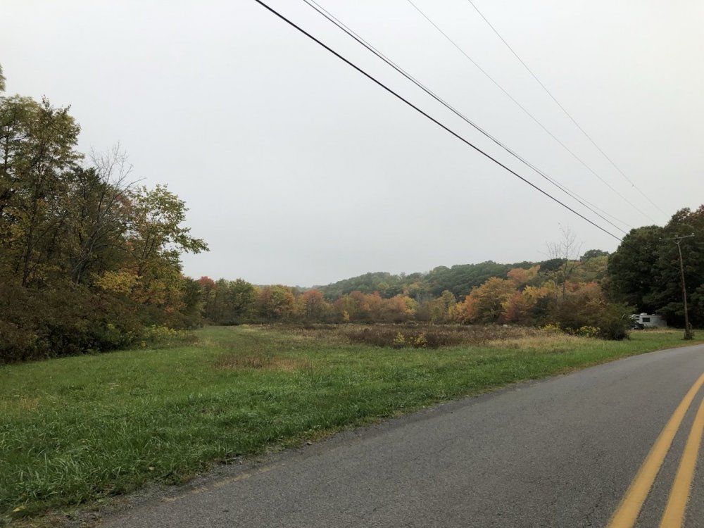
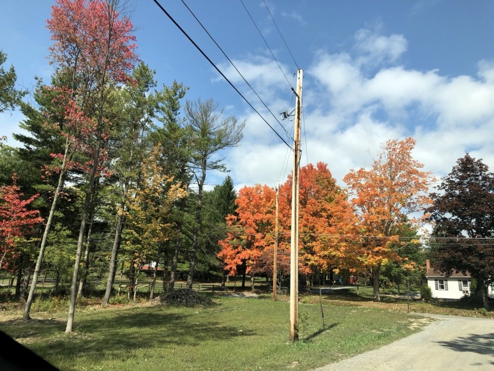
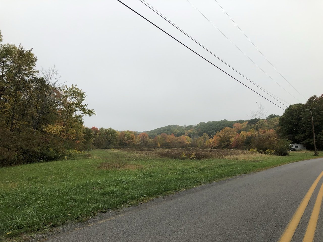
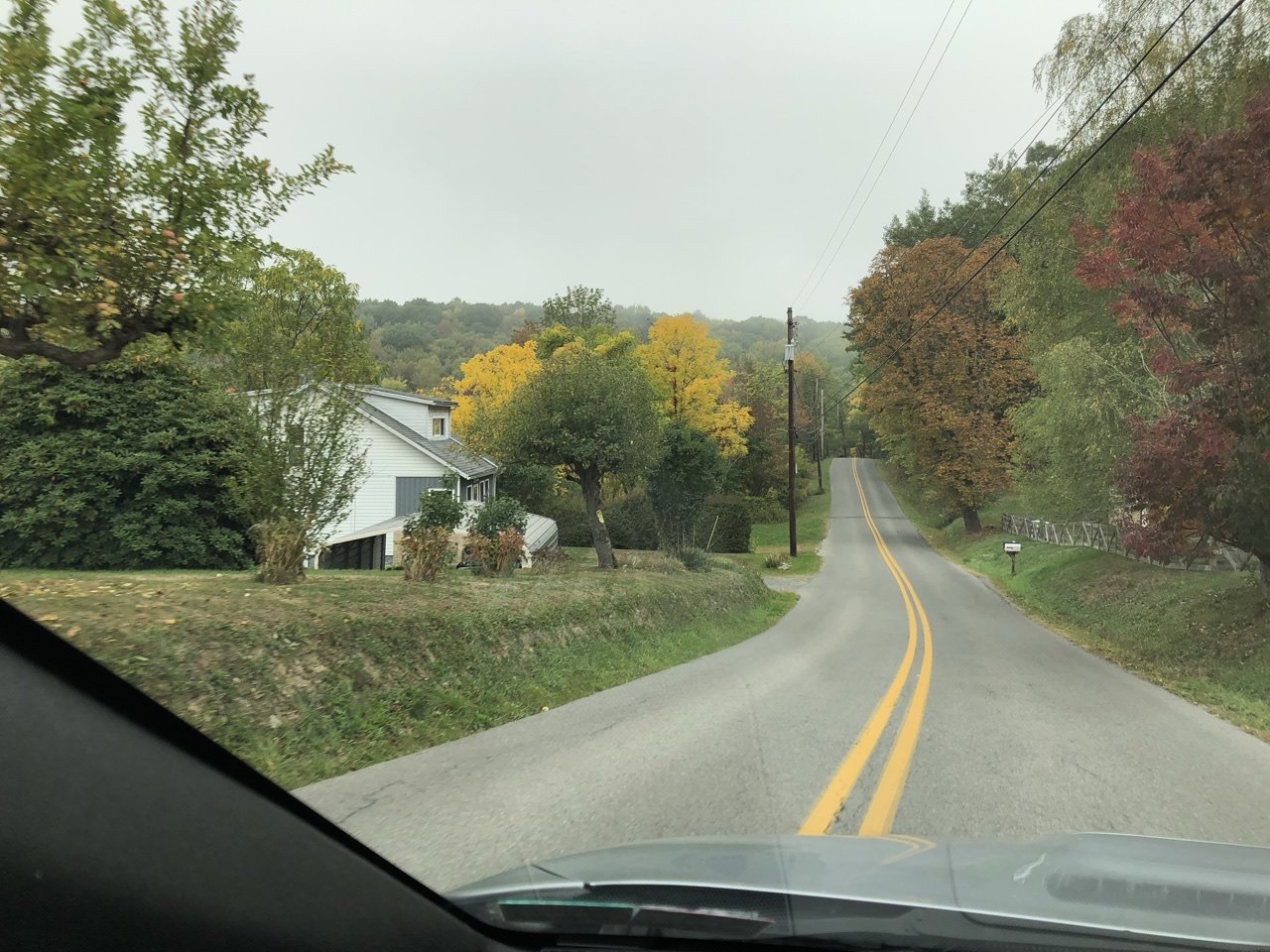
The early foliage has exploded this week around here. Probably the best color I’ve seen the last couple years or so.

-
3
-
-
Tracking the rain in the lower Sus Valley is a bit difficult due to the fact that both CCX (State College) AND LWX (Sterling, VA) radars have both been offline. Haven't seen anything about CCX in their discussions but the notes on RadarScope said it was having something installed Thursday that was supposed to only have had the radar down for 12 hrs.. so don't know what's up there. LWX radar had some kind of significant failure and it was noted on their website that its down til further notice with crews assessing the 26th (today). Good thing nothing major is going on, lol. In the meantime looks like best radar to use in the Sus Valley is either Mount Holly (KDIX) or BWI's terminal doppler radar (TBWI).
-
22 minutes ago, Blizzard of 93 said:
95-96 was probably the greatest Winter of my lifetime so far. It started early and ended late, and delivered 77 inches of snow to Harrisburg.
I remember it as a more front ended winter back this way, starting with that mid November storm that was even bigger than the 2018 storm. There was a couple impressive cold shots in early Feb and early March but it was Nov-Jan when we got just absolutely rocked by snow. And honestly being 9-10 years old that winter I remember the snow and the '96 blizzard to a degree but the one thing that I remember vividly in that winter was the flood. How it literally took away 90% of that gigantic snowpack in just a night with warm temps and torrential rain and caused all that mess and by lunchtime it was teens/20s snowing and everything froze back up while everything was still flooded. But yea, after the flood there wasn't really any noteworthy storms...at least here. I might have been suppressed out of some stuff in February before it warmed up second half of that month.
At any rate looking at the KPSU obs.. a whopping 77.4" of the observed 97.7" at the Walker Building Nov-March came prior to the Jan '96 flood. By month it was Nov - 23.4", Dec- 17.1". Jan - 41", Feb - 5.1" and March - 11.1". Thats nuts, even November on it's own pretty much about doubled up on last winter's total at KUNV (12.9") lol.
-
4 hours ago, Bubbler86 said:
Looking at the GFS and Euro MR forecasts it is entirely possible some people in PA will go the whole month with no rain (other than trace). That is pretty impressive in a bad way.
They're still showing a general chance of precip near the beginning of next week but not the big phase up yesterday's 12z runs had from both ops. GFS still seemed fairly rainy near Monday on 12 and 18z runs. I do think some kind of precip event will come out of that as we appear to be heading for a pretty sizable shift in the pattern next week.
What the GFS/Euro are both really showing today with solid ensemble support is a big time eastern trough/western ridge in the D8-10 timeframe. We'd definitely be starting October pretty chilly if that were to come to fruition.
-
9 minutes ago, Blizzard of 93 said:
83-84 looks like it was right around average with the total seasonal snowfall in Harrisburg.
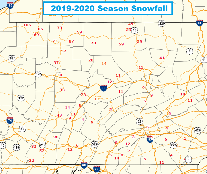
Here is a nice reference chart of the seasonal snow totals for Harrisburg since 1980 for courtesy of CTP.
Don't forget our barn burner of a winter last year, CTP just put the tallies of that one on their website that other day. Look at the huge difference between even some of the north central totals vs the northern border counties (US 6 corridor). Also, I dunno where that 11" was measured in the Altoona area but maybe I'm slant sticking haha.
-
I was glad my team (Steelers) got out of today pretty clean on the injury front. Lot of injuries today.
-
1
-
-
Euro with a similar big ticket amplification and precip event today to the GFS.
It seems like they entrain the remants of Beta (esp Euro) which looks to swirl about down in the Deep South most of the week. It still looks like a big amplification in the pattern with or without that extra charge. This is still out past D7, so obviously not getting too wound up on any details yet. Being that early next week timeframe is right near the beginning of October, we're getting to that period of the fall where we usually can see that first major system that jolts the pattern towards more of a mid-late fall regime. In the meantime, we warm up second half of the week while staying bone dry.
-
1
-
-
It was 35ish here this morning with patchy frost. Just outside of town several of the local meso obs were around 32ºF and it was a pretty solid frost. Looking like just about the same deal tonight. Eastern PA might have the coldest low temps tonight.
Eyeing up late next weekend/Monday for the next precip chances in the area. Models have generally had something there and 12z GFS went for a phase and cutoff with an excessive rain event in the central counties. I'd say the West Branch might go positive again if the GFS 2-5" stripe in 24hrs between the western Laurel's and the Sus River came to fruition. Still way out there...but as mentioned, models have shown more widespread QPF in that timeframe. Other hopefully good news later this week is models have been showing a Pac NW system coming in mid-late week.. so hopefully some of that gets down at least into Oregon and knocks down some of those wildfires.
-
1
-
-
Light frost here this morning and it got down to 34-35ish. If i'm seeing a bit of it in town I'm sure the usual spots outside of town probably had a pretty heavy frost or even a freeze. Several meso stations below freezing in the immediate area. Station in Philpsburg reporting a 27ºF and a couple on the outskirts of State College and near Port Matilda 30-31ºF.
-
4 minutes ago, Bubbler86 said:
Cover the plants.
Fortunately the only thing I really got going outside right now is the two Knockout rose plants i planted in the late summer.. which are supposed to be fairly hardy to chilly nights like that. That mid May hard freeze and snow we had I don't know how that didn't take out some of the stuff that was growing then like the daffodils and the fully bloomed Magnolia tree.
-
Wow lows in the mid 30s here the next 4 nights in a row. Sometimes we don't get a run like until most of the way through October.
QuoteTonight
Mostly clear, with a low around 37. North wind 5 to 10 mph becoming light after midnight.
Saturday
Sunny, with a high near 60. Calm wind becoming northeast around 6 mph in the afternoon.
Saturday Night
Clear, with a low around 36. Light northeast wind.
Sunday
Sunny, with a high near 64. Northeast wind 3 to 6 mph.
Sunday Night
Clear, with a low around 35. Calm wind.
Monday
Sunny, with a high near 65.
Monday Night
Clear, with a low around 37.
Tuesday
Sunny, with a high near 71.
Tuesday Night
Clear, with a low around 49.
Wednesday
Sunny, with a high near 76.
Wednesday Night
Mostly clear, with a low around 52.
Thursday
Mostly sunny, with a high near 76.
Thursday Night
Mostly cloudy, with a low around 51.
Friday
Partly sunny, with a high near 71.
-
Smoke's maybe a tad thinner tonight. You can see some of the brighter stars tonight where last night about the only thing you could see was Mars, which is currently one of the brightest objects in the night sky (closest approach to Earth Oct 6th). Still can't really see much though, which is a bummer for star gazers b/c you couldn't ask for better viewing conditions right now between the clear/dry conditions (sans the smoke layer) and an almost new moon.
-
7 hours ago, Superstorm said:
Any thoughts on what smoke particles does to atmosphere? Is it similar to volcanic eruptions?
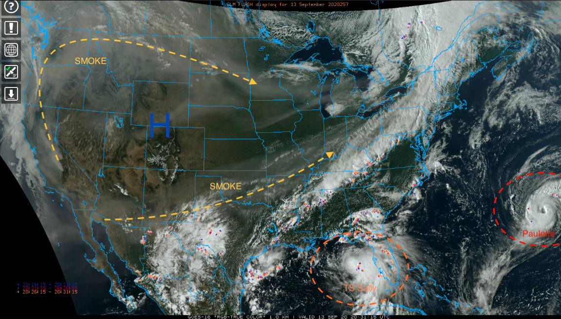
That's a good question. My best take on that would be it's kind of a yes and no type thing. Yes the smoke particles limit the sun's radiation and that of course has an affect on surface temperatures, which we're seeing the effects of today. I don't know if i've ever seen wildfire smoke so widespread over the US. Part of it is a product of the pattern, most of the US is in a stagnant regime with broad 500mb ridging across the CONUS. Thus the smoke is just rounding the broad high pressure and not getting cleared out by any systems. The setup is also stuffing Hurricane Sally and making that a likely major flooding situation in that part of the Southeast when it finally makes landfall.
Where it is not similar is duration/scope as well as makeup of the ash. I would imagine one is thinking of the long term global cool down as a result of a really major volcanic eruption scenario. When a big time volcanic eruption occurs, that will drive the volcanic ash all the way into the stratosphere. The wildfire smoke is riding the jet stream at about the height of a cirrus deck in our parts. High up but still in the troposphere. Weather will eventually clear the wildfire smoke particles (or volcanic particles) out of the troposphere. Dispersing volcanic sulphates takes a much longer time in the stratosphere. Also, being that volcanic ash is actually pulverized rock/minerals/glass.. it is likely a good bit more efficient at reflecting the sun than wood ash is.
-
KAOO was down to 40ºF last night, and a look at the local mesowest stations showed about the same (39-42ºF). One of the Penn State Ag stations in the fields SW of State College was down to 36ºF as was one near Port Matilda. Those valley areas, especially the Barrens region which is near the Penn State agricultural fields are very good radiational cooling areas so it's likely there was some scattered frost this morning even in this general area.
-
 1
1
-
-
3 hours ago, Bubbler86 said:
So after last evening the data suggests a smoky sky is not one that will limit radiational cooling like a cloudy sky.
This was my post on this last night, as CTP had a good explanation in their discussion.
15 hours ago, MAG5035 said:Pretty interesting and informative disco from CTP tonight...A little reminder of Meteo 436 (Atmospheric Radiation) a long time ago. Adjusting temps down some tomorrow due to the smoke remaining in the upper levels. Frost advisory up for McKean County (Bradford area) tonight.
Quote.NEAR TERM /THROUGH TUESDAY/... Efficient radiational cooling associated with surface high should result in a chilly overnight. Although a large area of smoke has moved in over the area, this should not impact overnight low temps. Smoke can filter out shortwave radiation from the sun resulting in cooler days, but is not as effective in absorbing longwave radiation (the smoke particles are too small), so it has little impact on overnight low temps. Diurnal mixing will diminish early this evening, bringing nearly calm winds. A large spread between air and stream water temperatures should result in the typical dendritic pattern of valley fog across the Alleghenies after midnight. In addition, latest guidance lends increasing confidence in areas of frost in the normally cooler hollows of northwest Pa. A frost advisory is in effect for Mckean County where the frost is expected to most widespread, with more patchy frost anticipated elsewhere across the northwest mountains. Large scale subsidence and dry air associated with center of surface high should translate to a virtually cloudless Tuesday. However, we will continue to see smoke advected in aloft from the wildfires out west. As such, knocked down high temps a few degrees for Tue, with temps generally not getting out of the upper 60s. Dewpoints will remain around 40F, possibly lower if we can mix up to the very dry air near 5kft, but was not too aggressive with mixing due to smoke filtering the sunshine.
-
1
-
-
Pretty interesting and informative disco from CTP tonight...A little reminder of Meteo 436 (Atmospheric Radiation) a long time ago. Adjusting temps down some tomorrow due to the smoke remaining in the upper levels. Frost advisory up for McKean County (Bradford area) tonight.
Quote.NEAR TERM /THROUGH TUESDAY/... Efficient radiational cooling associated with surface high should result in a chilly overnight. Although a large area of smoke has moved in over the area, this should not impact overnight low temps. Smoke can filter out shortwave radiation from the sun resulting in cooler days, but is not as effective in absorbing longwave radiation (the smoke particles are too small), so it has little impact on overnight low temps. Diurnal mixing will diminish early this evening, bringing nearly calm winds. A large spread between air and stream water temperatures should result in the typical dendritic pattern of valley fog across the Alleghenies after midnight. In addition, latest guidance lends increasing confidence in areas of frost in the normally cooler hollows of northwest Pa. A frost advisory is in effect for Mckean County where the frost is expected to most widespread, with more patchy frost anticipated elsewhere across the northwest mountains. Large scale subsidence and dry air associated with center of surface high should translate to a virtually cloudless Tuesday. However, we will continue to see smoke advected in aloft from the wildfires out west. As such, knocked down high temps a few degrees for Tue, with temps generally not getting out of the upper 60s. Dewpoints will remain around 40F, possibly lower if we can mix up to the very dry air near 5kft, but was not too aggressive with mixing due to smoke filtering the sunshine.
-
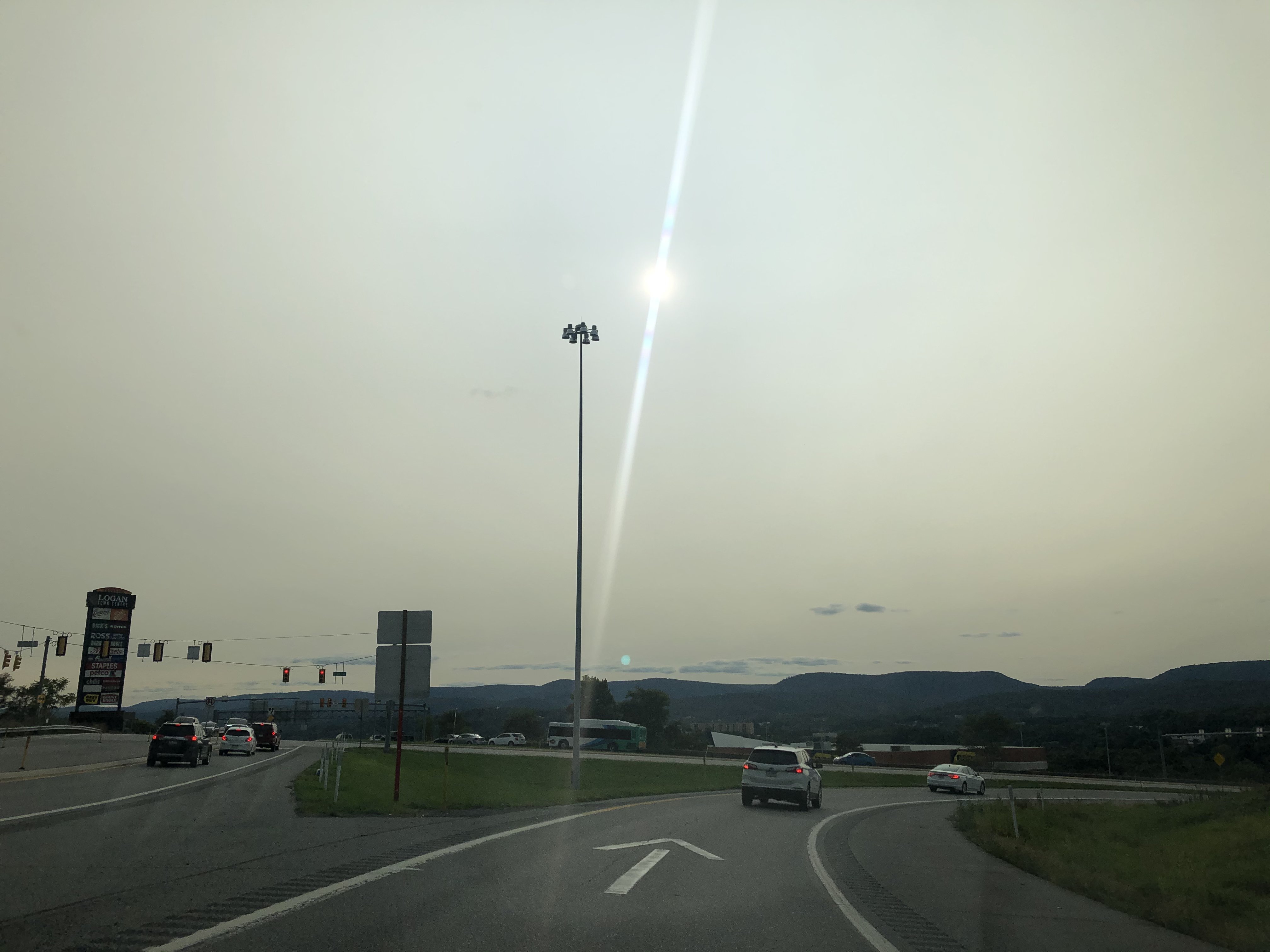
Pretty impressed how much the sun was filtered through the smoke in the higher levels today. Took this coming back into town about 20 min ago.

-
I don't think we've made it to 70 here today under the clouds and had a couple decent showers late morning/early afternoon. Pretty much been cloudy here since Friday.
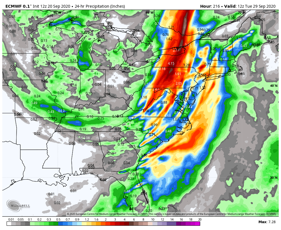
You can see on satellite how the frontal system working through central PA this afternoon has drawn some of the western wildfire smoke up into it at the higher levels from the SW and also from the NW some. Also you can see the two big ticket tropical items Paulette and Sally. Will have to see how much Sally eventually gets drawn up north before being shoved out ahead of another frontal push late week. Euro ensembles show some reasonable precip chances southern half of the state but right now it seems the general model consensus is the majority of eventual remnants stay south of PA. So we'll see how that goes. Right now Sally's being forced under the current frontal boundary to take its forecasted WNW toward the LA coast. That's also contributing to the westerly shear on it attm as well. Hopefully it doesn't get too wound up, because that is a bad angle to take towards New Orleans.

Next weekend looks dare I say, kind of chilly behind the system that eventually kicks Sally away. Could be a decent chance of some frost in northern PA as well as the usual cooler suspects in the Laurels and central counties. The first couple days this week after the passage of today's system looks pretty nice as well, with Tuesday morning the chilliest and a more limited frost chance (Bradford/Allegheny National forest region).
-
1
-
-
On 9/11/2020 at 3:07 PM, Cashtown_Coop said:
Course not the house the record. I was 0.000 at home. The rain at course was perfect. Get to keep the system off all weekend. I tore my lateral meniscus so things have been hard the last 3 weeks. Mother Nature on my side this time.
On 9/11/2020 at 3:54 PM, 2001kx said:I wish it was but had a rough couple months..
Was hit in the face by a rock during an Motocross Race..Busted my goggles.
Fractured my eye socket, cheek bone, around my nasal cavity and above my upper back teeth (jaw bone)
But the worst part is my eye has a blurry spot in the middle and my pupil doesnt work (always big / open) and the dr. said it may never get better.
Other than that it has been good -lol.
Goodness I hope everyone has a quick/full recovery from all the injuries. We're gonna have to put out an injury report when we're full swing in the wintertime at this rate lol.
-
 1
1
-
-
Today was low key one of the more muggy days of a summer that's had wall to wall hot weather but not necessarily much of the hot/humid combo.
7 hours ago, Itstrainingtime said:Oddly enough, it's rained more than it hasn't since noon here. Yet, most of the rain has fallen when the sun was at least visible if not out completely, and the only times it hasn't been raining is when it's been dark as night.
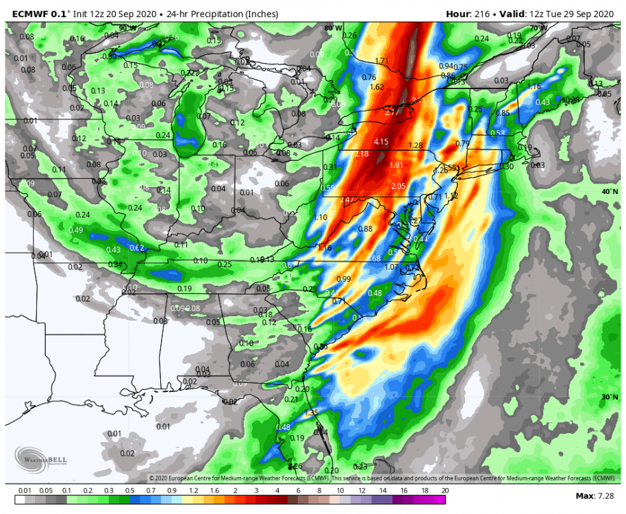
DC area is getting crushed right now. Bad situation developing down in southern MD and DC metro area. Sounds like water rescues are ongoing...
That region seems to be on the kind of insane run of way above average precip that the LSV saw the last two summers (especially 2018).
-
1
-
-
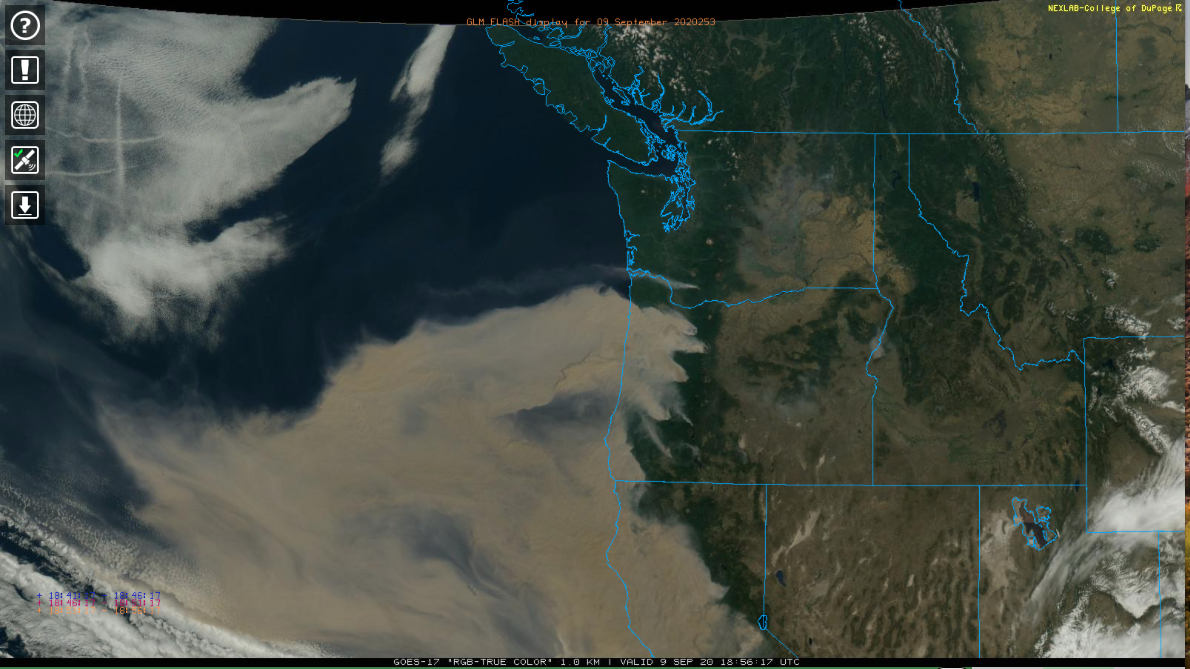
Also, since it's fairly boring around here today.. here's another shot of how widespread the wildfire smoke is in the Pac NW and California. Also jet contrails in the clouds on the NW corner of that shot over the Pacific.


Central PA 2020 Fall - The Hope begins
in Upstate New York/Pennsylvania
Posted
Been a classic mid-fall rainstorm day today around here, with periods of rain of varying intensity and cool temps in the low-mid 50s.