

MAG5035
-
Posts
5,884 -
Joined
-
Last visited
Content Type
Profiles
Blogs
Forums
American Weather
Media Demo
Store
Gallery
Posts posted by MAG5035
-
-
This thing kicked it into an even higher gear when it got into NWS BGM territory. Multiple counties with 40"+ reports, including right around NWS Binghamton themselves. Incredible.
-
 1
1
-
-
My mom forwarded me pics from a couple of her friends up in her hometown of Renovo, Clinton County where that band sat for awhile last night.
K&L Auto just outside of town
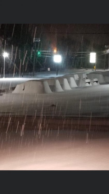
Tamarack
-
4
-
-
15 minutes ago, sauss06 said:
just heard someone around or in Bradford county got 40"
Where that band set up and sat last night over those north-central counties got in excess of 2 feet, so a 3+ foot total somewhere isn't out of the realm of possibility. The models having the 20-30+ swath for days ended up being right in the end, just that it ended up being more W than what any model had and then it did arc over to Williamsport.. although the worst of that band was actually north of IPT for awhile and they still got what they did.
I don't know what happened here. Looking at you guys' totals this morning, my 10.7" is on par with @Itstrainingtime and the Lancaster folks with some of the ones around Harrisburg actually doing slightly better even with the sleet. This was a big bust for me personally, as I was expecting mid teens here and when yesterday mornings models came in at the beginning of the storm I thought 20" was realistic. I think that intense band setting up just to the west of here for awhile got me into a subsidence zone. I never got the 2-4/hr rates. I'm still happy, it's a double digit snowfall in December either way. Roads are still a mess this morning and my back street hasn't been plowed yet. Couldn't imagine folks that ended up with more than twice of what I got.
-
1
-
-
1 hour ago, Hoar_Frost said:
I will look for sure in a bit, but it might be on par with a 2010 storm. Otherwise, probably best since '96.
The February 2003 storm (PD2) had 18.2" measured on campus. And there was a sneaky forgotten about nor'easter Jan 6, 2002 that dumped about 13-15" in UNV. I think the Feb 5-6, 2010 storm was also about 13-15" in the UNV area as the really high totals were just south. So sounds like you guys did about as good or better than the Feb 2003 event, that's pretty good company to be in.
-
10.7" was my final here.
-
2
-
-
Been back to a decent snow after a bit of a lull for awhile. Finally arriving at the 10" mark.
-
1
-
-
6 minutes ago, Wmsptwx said:
It’s dumping snow here right now. You think we have chance of 2 to 4 more?
Definitely. Only question there would be if you get that 2-4 within the next hour lol
-
4 minutes ago, 2001kx said:
My car...I cleaned it off when we had about 5"
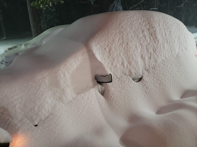
That’s awesome. 20 is probably doable for you.
That main snow band is just sitting over rural Clinton and Lycoming. Renovo would probably be quite the place right now.
-
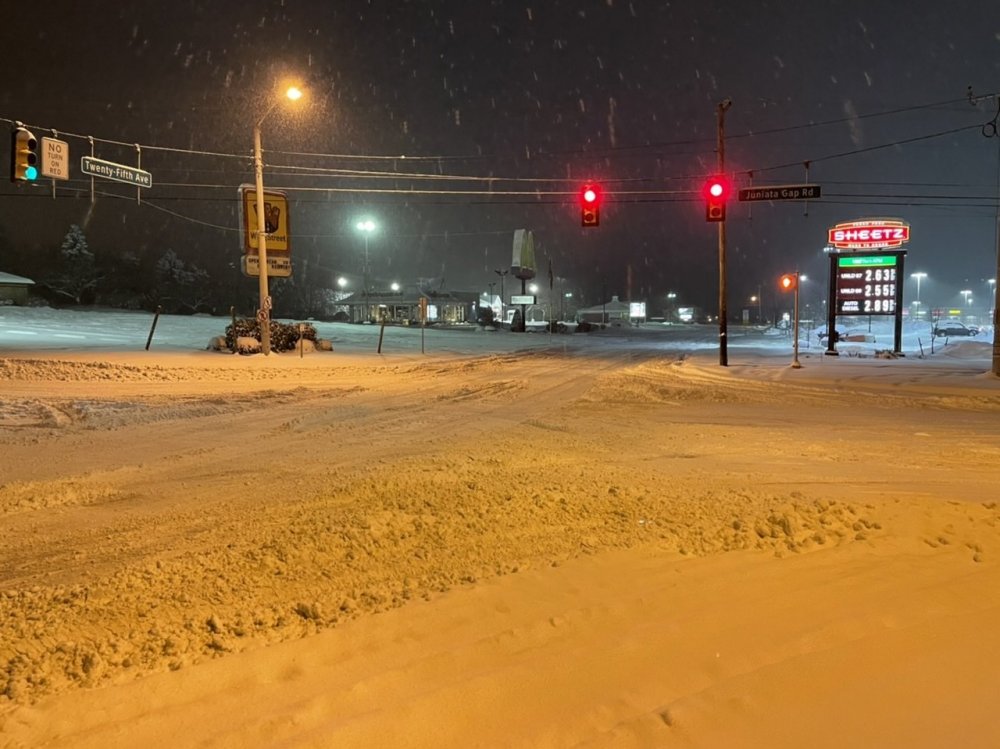
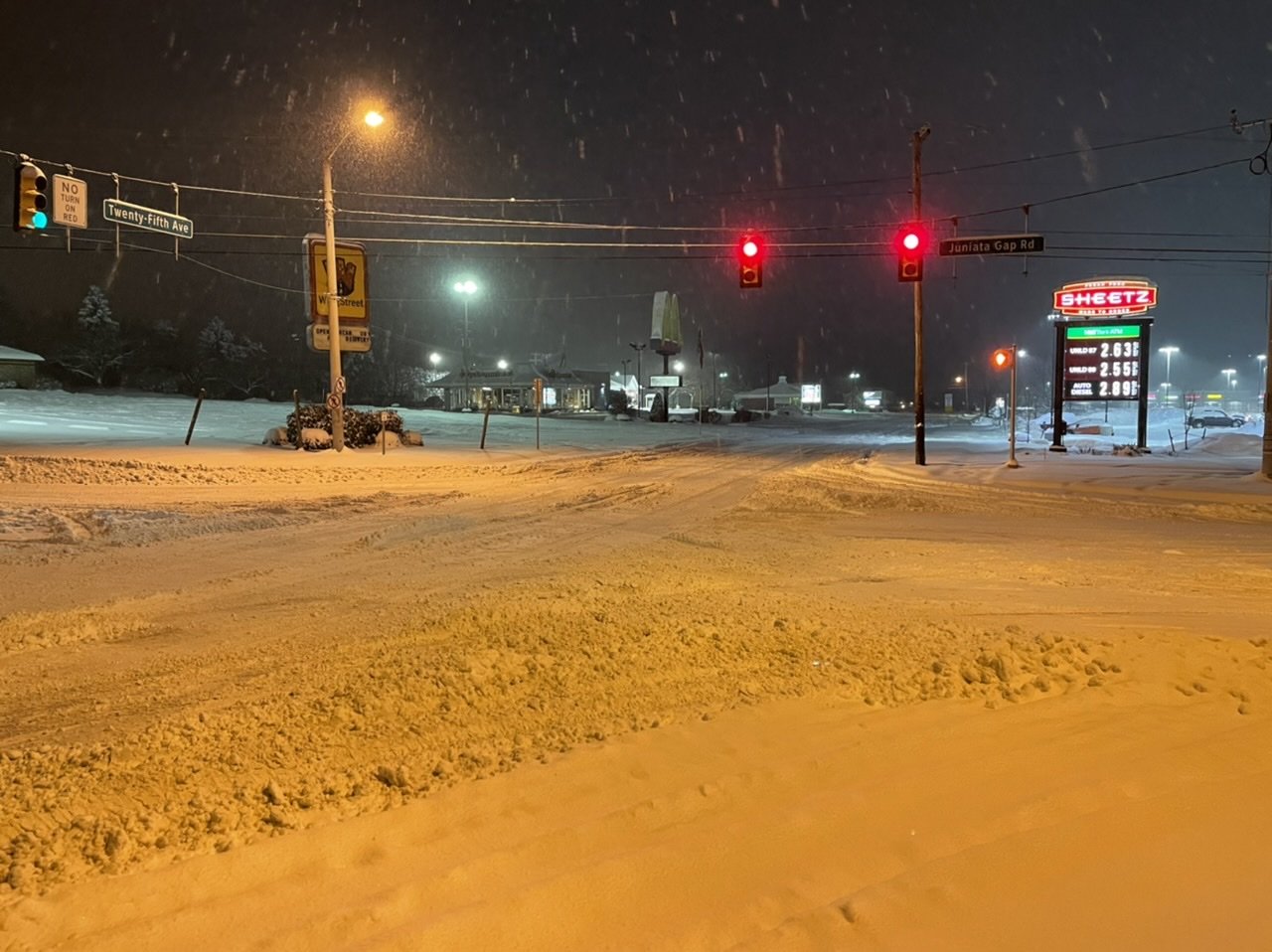
I Jebwalked on down to Sheetz just a bit ago. Prob gonna take a good part of the morning to get roads straightened up after the snow stops.

-
5
-
-
1 hour ago, Hoar_Frost said:
7.2" from 7:30 to 11:00 PM. Storm total so far: 16.3".
Wow that's impressive, are you in State College? That's a pretty big difference from State College to down here in Altoona if so. I'm between 9.5"-10". Just didn't get those rates in that timeframe with the deform banding settling just west and NW of here.
-
21 minutes ago, CarlislePaWx said:
Change back to snow here began about 45 minutes ago. Still some sleet but more snow now with big flakes. I cleared off my board again and melted down the sleet. The sleet measured 1.3" total and the sleet melted down to 0.43" of liquid! Not far from 3:1 ratio. So the 4 1/2 hours of sleet would have been 4" of snow had it not changed over. So total liquid for the storm is now 1.04" which consisted of 5.5" of snow and 1.3" of sleet for a frozen total of 6.8".
Anxious to see if the big surprise it outside tomorrow morning when I get up. NWS calling for 5 to 9 inches overnight. Here's hoping. Big congrats to everyone west of here that have scored big this event!
1.3" of sleet?? Congrats in advance on the white X-mas lol.
-
22 minutes ago, Voyager said:
We flipped to sleet when I was walking down to the fire, and now even the sleet has shut off. What level was above freezing? According to my app, everything up to 850mb is 31 or lower.
Slightly higher than 850mb level, about 800-850 mostly. Here's a cross section of the NAM at 0z at it's 0hr initialization. Did the cross section from roughly Huntingdon county to Allentown with Harrisburg in the middle.
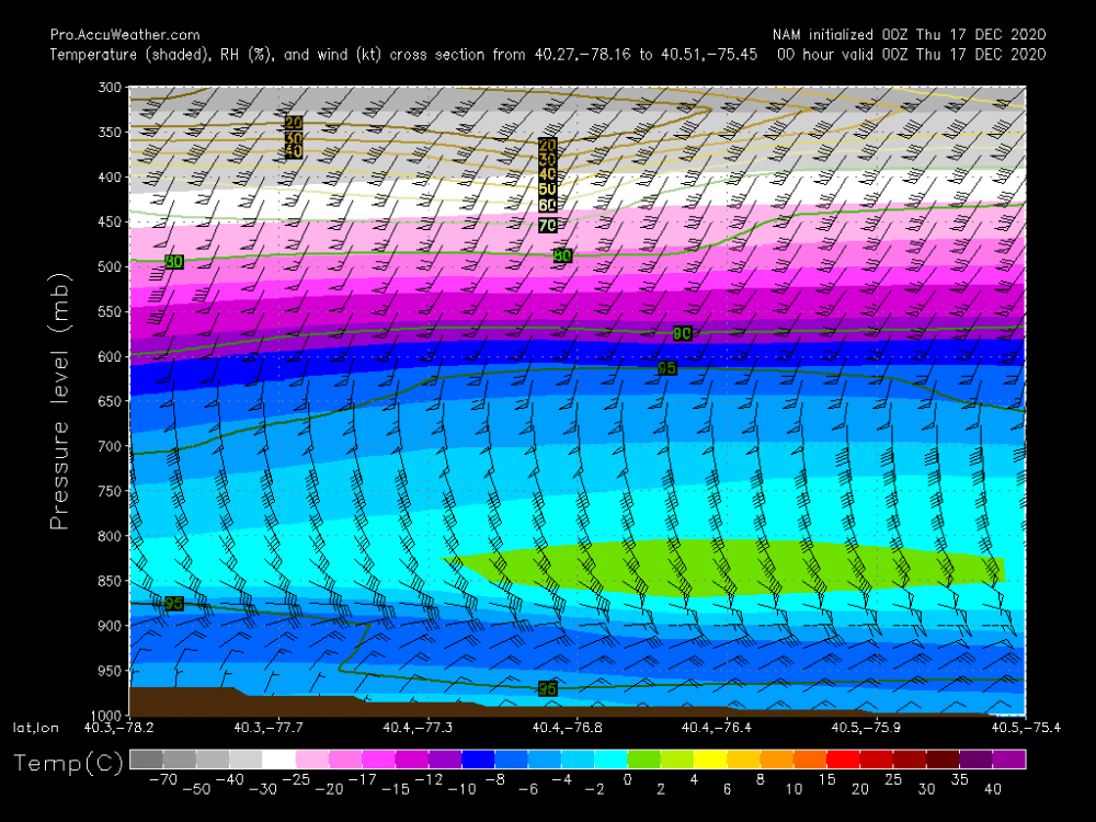
That line for producing this cross section is drawn slightly south of Tamaqua. Doing one from here across to NJ with Tamaqua in the middle didn't have that patch of slightly above freezing air but that broad layer of near 0ºC. Likely was just a enough of a warm tongue to do the trick to get sleet.
-
@jim123 Yep the pivot is starting to become evident on radar. This def bodes well for at least State College. Need a bit of building near Somerset County to feel better about keeping the decent rates here in Altoona, but looks like it's trying to do that.
-
2
-
-
8.6" with heavy snow falling now. Bigger and fluffier flakes with this current burst of heavier.
-
20 minutes ago, 2001kx said:
yep had to get the yard stick..how long do you think this will last here?
Probably the next hour at least (edit: I'm talking just about the heavy band, not the rest of the event lol). I'm watching to see what that weak spot in returns does down in Somerset County and if we keep building some banding. Back to heavy snow here but probably not as heavy as there.
-
1
-
-
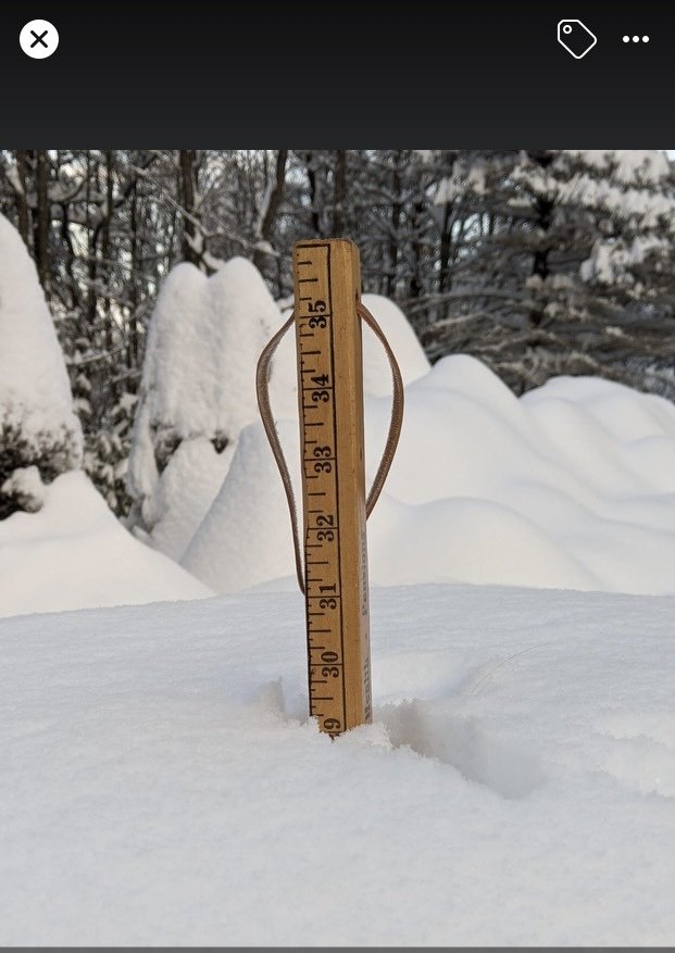
Just now, 2001kx said:
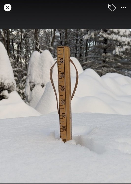
it just keeps getting heavier...up to 13" as of 9:25
I see you had to switch to a bigger ruler haha.
-
 2
2
-
-
47 minutes ago, pasnownut said:
Thanks bud. Wasn’t sure. I’d take .8” sleet with a couple inches on top.
You think you’ll get to 18”? From mesos I think you’ll be right close.Next couple hours are crucial but my chances for getting that high are slipping away the longer that band stays arced to my NW and north. It seems to be setting up over 2001kx over to just NW of IPT. @2001kx has to be getting crushed. This is the band that's going to see the excessive totals and it's setting more NW than any guidance had it earlier today.
Up to 8" with moderate rates. Snowing decent but I probably lost my outside chance at 20".
-
1
-
-
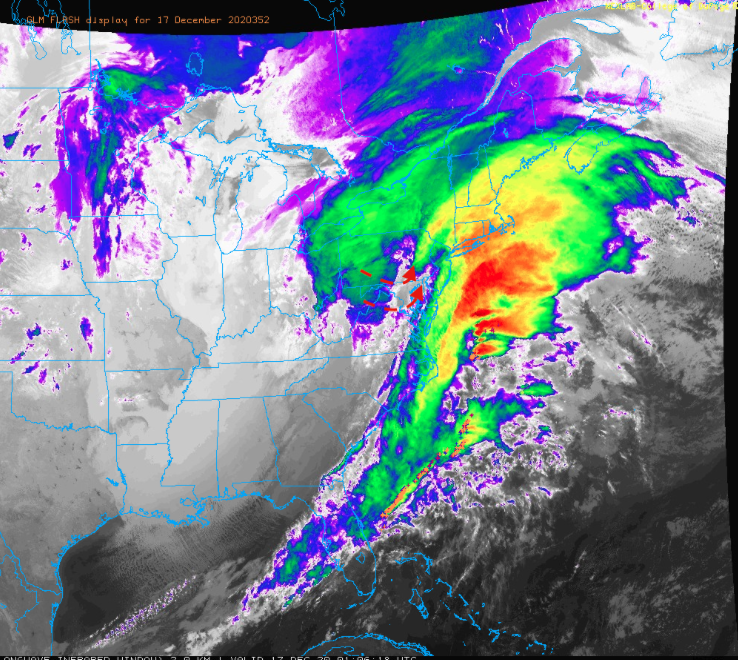
You can see the dry slot on the IR, if you put it in motion you can see the comma head shifting towards the Sus Valley.
-
1 hour ago, Blizzard of 93 said:
How is the surface low track looking in real time?
How soon could the LSV go back to snow as the coastal low further develops & heads northeast?Mesoanalysis has the low roughly on the southern tip of the Delmarva currently. So track doesn't look to end up as far NW as some models had it but the models like the Euro and especially NAM got the stronger warm nose aloft correct. I was def thinking mix in southern York/Lancaster but didn't think it'd get as far north as it did. That tremendous 850mb fetch likely had a big hand in that.
I'd say things will probably get changed over once heavier precip starts shifting back into the Sus Valley (and also comes up from the SW by looks of the LWX radar). Likely within the next couple hours.
-
1
-
-
4 minutes ago, 2001kx said:
Up to 10" now
That's a nice band your set up in right now, it does seem these deform bands are setting even more NW than some of the more NW guidance had them.
-
1
-
-
7 minutes ago, pasnownut said:
Wonder how well it does with factoring sleet in?
WeatherBell doesn't include sleet in it's snow map like TT does. There's a separate accumulation map for sleet (using a 3:1) map.
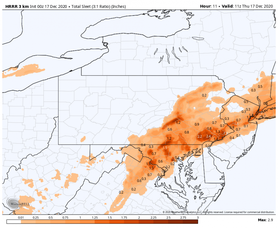
Which brings the question, does anyone have any noteworthy sleet accumulations to report? Typically I'll measure and clear when a transition occurs and measure the sleet separately.
-
7.6" and moderate snow. Waiting for that deform band to shift over just a little bit more.
-
1
-
-
7.0" Moderate snow.
That band associated with the thundersnow over Mt Davis (Somerset County) is lurking. I did see the GLM flash product on the COD satellite page pick up on about two or three strikes back about an hour ago. The extra instability likely aided by the SE flow over the one ridge line in that region.
-
8 minutes ago, canderson said:
Tom Russell (CBS21) says dry air is gonna hurt everyone in the LSV.
13 minutes ago, canderson said:Now hearing sleet on the windows. Not ideal in Harrisburg.
So the pingers did make it to H-burg. I'm pretty surprised the mix line got up that far, so looks like the NAM et al ended up being more correct thermally aloft.
In terms of the dry air post I mean yea it does appear the slot is going to get into the LSV, although judging by LWX radar trends its more of a slot of lighter rates than an actual dry slot. Since the columns already busted, the lighter rates will probably ensure some mixing continues until the heavier bands start shifting back east/northeast later tonight and heavier rates and dynamics likely turn things back to snow. The pivot isn't completely obvious yet but it does appear like it's showing some signs of starting, so watch radar trends on CCX radar.


Central PA - Winter 2020/2021
in Upstate New York/Pennsylvania
Posted
PSP Update on that I-80 wreck in Clinton County yesterday, 55 commercial vehicles and 11 passenger vehicles.
https://wjactv.com/news/local/police-interstate-crash-with-dozens-of-vehicles-kills-2