

MAG5035
-
Posts
5,718 -
Joined
-
Last visited
Content Type
Profiles
Blogs
Forums
American Weather
Media Demo
Store
Gallery
Posts posted by MAG5035
-
-
3 minutes ago, kerplunk said:
Thanks for the clarification and analysis. Always have problems getting the "previous" portions straight with the update time.
Those CSI band locations are always a crap shoot - even during the height of a storm.
Your welcome, and actually CTP has just updated their disco. They got all the good details in there haha.
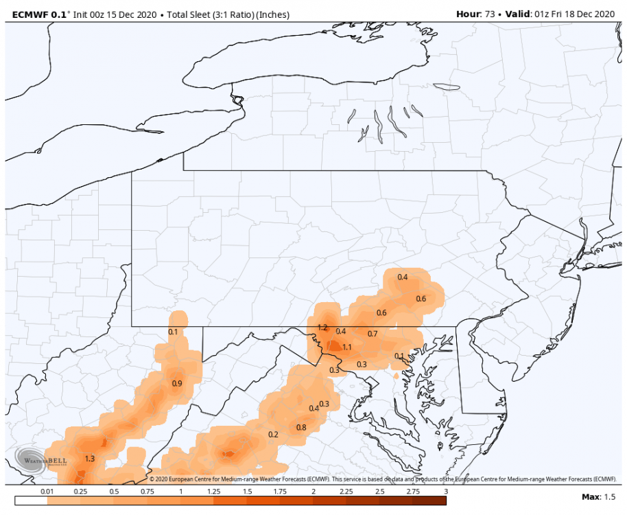
Quote.NEAR TERM /THROUGH TONIGHT/... Loop of the Nighttime Microphysics channel shows mid and high cloud shield spreading steadily NE and thickening up across PA in advance of what looks to be a likely record-breaking snow storm for December (with respect to both 1 and 2 day snow totals at Harrisburg, State College and Williamsport that were mainly in the lower to mid teens). Temps ranged from the mid teens across Tioga County, where minimal cloud cover occurred for the longest period earlier in the overnight, to the mid 20s in the south. Winds were mainly from the east at 5-10 kts with some minor gusts. A major winter storm will impact central PA this afternoon through Early Thu morning, with snow accumulations of 1-2 feet expected, and snow rates as high as 2-4 inches per hour Wed night. Very little change was made to the previous snow totals, except for adding some small variations in snow totals based on elevation within the axis of heaviest snow from the Scent Mtns to the Middle Susq Valley and Western Poconos, and tacking on a few inches across Mckean County - placing them in 18-24 hour Winter Storm Warning criteria acrs the SE half of the County. All model guidance is in very good agreement with respect to the evolution, track, and intensity of the consolidating and intensifying sfc along the Delmarva Coast early tonight. Expect a high probability for over 1 foot of snow within the region bounded by I-81 and I-80, with as much as 20 inches in spots from Scent PA, to the Western Poconos and Endless Mtns region NE of KIPT. This target area will see a one-two (maybe even three) punch of warm advection heavy snow later this afternoon and evening, followed by a period of peak CSI-banded heavy snow with the potential for Thunder snow later this evening through a few hours after midnight as the nose of a strong, 50-60 kt easterly 850 mb jet and 130 kt upper jet focuses hefty uvvel and slantwise instability near and just to the NW of the I-81 corridor. Intense snowfall rates of 3-4 inches per hour will accompany these CSI bands, which will make travel extremely difficult to near impossible with very poor vsbys and road conditions. Concerning the onset timing of the snow, latest HRRR runs have the snow beginning along the southern PA border around 15Z (10 AM EST), around noon along Interstate 80, and 1-2 pm across the northern tier. Model simulated reflectivity and snowfall rates steadily ramp up across the southern half of PA between 18-20Z and early this evening across the Northern Tier of PA. A host of 00/06Z Wed Op Model/Hi-Res EFS data continues to indicate the likelihood of a mid/upper level (700-500 mb) dry slot surging NE across the region near and to the east of the RT 15/I-81 corridor in the Lower Susq Valley and Western Poconos later this evening through the first half of tonight. Max wet bulb temp in the 925-700 mb layer near the nose of the anomalously strong eastern LLJ will poke up into the 0 to 3C range near and to the south of a line from Gettysburg to York and Lancaster in the 012-05Z Thursday period which is near the time of peak precip rates. After the lead surge of WAA moderate to heavy snow, some sleet should mix in near and to the southeast of a York-Lancaster line Wed evening, trimming the snowfall amounts by several inches or more. This feature aloft and its impacts on precip type and snow accum rates will keep us honest in displaying at least a gradual gradient to lesser snow amounts of only 9-10 inches across far southern York and southern Lancaster Counties, while much heavier amounts of snow fall to the NW of I-81. This will be the time when snowfall rates near and just to the NW of the I-81 corridor will be 2-4 inches per hour in developing CSI bands. If the NW extent of this warm wedge doesn`t make it that far north to cause some sleet, our Lower Susq Valley counties could be under the gun for near Blizzard Conditions. Thundersnow is possible early tonight near and to the NW of the I-81 corridor. Cold Conveyor belt/FGEN moderate snows with near 1 inch per hour snowfall rates should linger until around, or shortly after daybreak from KUNV to KIPT and points NE, leading to the axis of heaviest snow near or just to the SE of that axis with some areas seeing 18-20 inches for high-end storm total amounts. The storm will be relatively quick moving, with most places seeing precip for 18-24 hours. Nonetheless, with cold temperatures in place, good SLRs, and very strong frontogenesis, this should end up being the most significant snowstorm for most of the area since November 2018... and for some areas, perhaps one of the heaviest snow events in the past 5+ years. It also may rival some of the record 1-day and 2-day December snow totals. For reference, the December 2-day record snowfall at Harrisburg is 13.9 inches, set in 1961.
Also, they have a climo section for record snowfall.. which this is poised to break 2 day largest snowfalls for December in all the CTP climo stations (UNV, IPT, MDT).
Quote.CLIMATE... The last time there was 12+" of snow over a two day period (as many storms will cross from one date into another): State College: 6-7 Feb 2010 = 14.0" Harrisburg: 20-21 Mar 2018 = 14.2" Williamsport: 14-15 Mar 2017 = 18.4" Last time there was an 24+" storm (not sayin`, just sayin`): State College: 3-4 Mar 1994 = 27.7" Harrisburg: 22-23 Jan 2016 = 30.2" Williamsport: 12-13 Jan 1964 = 24.1" (the only two-foot storm for Williamsport) Highest two-day total: State College: 29-30 Mar 1942 = 30.5" Harrisburg: 22-23 Jan 2016 = 30.2" (that one, again) Williamsport: 12-13 Jan 1964 = 24.1" (that one, again)
-
24 minutes ago, kerplunk said:
Area Forecast Discussion
National Weather Service State College PA
315 AM EST Wed Dec 16 2020
SHORT TERM /9 AM THIS MORNING THROUGH 6 PM THURSDAY/...
Main changes to the short term grids (the main event) were to
nudge the axis of the heaviest accums to the NW by 20-30 miles
and add a little, too. This is in line with a slight shift west
of the dry slot and best slant-wise instability (for the banded
structures). Latest model QPF and SLRs argue for even higher
numbers with State College and Williamsport in an axis of 24+"
accums. We will not take it to that extreme of a change in
either axis of the highest accums nor the SF totals. But, a
nudge in that direction seems prudent.That portion of the disco hasn't been updated since about 10 last night. However, overnight and early morning guidance (6z) have continued to support that notion of a 24+ axis somewhere between I-99 and I-81 northeastward toward the Poconos. Exactly where is likely going to eventually be determined by today's near term guidance as the event unfolds. Still trying to adjust to the fact that we're trying to pinpoint the highest totals within a nearly region wide foot plus in all guidance for us haha.
I think CTP has a good handle with their current snow map. I do like that general area of Lewistown to Selinsgrove up to Williamsport for the best opportunity to get to two feet or perhaps beyond. For State College I'm thinking 14-18", but definitely a shot to get past 20 or so. Gonna depend how far back those CSI bands set up the first half of this evening, and to a lesser degree how well the storm accumulates rate and ratio wise during the WAA phase of precip today. If State College does get into the thick of it, I'd look at the 7 mountains region of US 322 between there and Lewistown for something ridiculous. Again, this is pinpointing where these excessive totals might pop up within the general 10-20" this whole region stands to see.
Making a fairly safe call of 14-16" for the backyard (Altoona), it's weird saying that much is a "safe" call haha. They're sort of in the same boat as State College with perhaps the outside chance of seeing 20.
-
 1
1
-
-
Way too early look at the 6z HRRR which extends out on the 0,6,12,and 18z runs seems to jive okay with things.

For some obs here, it's a nice crisp 26ºF currently with some increasing clouds and a light easterly breeze.
-
11 minutes ago, Wmsptwx said:
If everyone in forum gets 10 plus, this will be my fav storm in memory. We always talked about it, but to see it really happen would be just awesome. Hoping kpit uses ratios to get to over 6 as well.
How do you feel about good ole Williamsport being a snow chasing destination for this storm? Haha
-
1
-
-
39 minutes ago, Wentzadelphia said:
Hey folks. I’m headed to Williamsport early tomorrow morning. I’m beyond excited haha...couple questions
1) looks like the storm ends early tomorrow. How are the roads up my way? I should be near an interstate. I drive a car not a truck/suv. Think I may be able to get out Thursday night?
2) how’s the instability looking up this way? I’d love to experience some thunder snow.
3) my goal is 18” I think the duration will hurt a bit. I think the snow maps are a bit overdone because of it, but who knows. Do you guys think someone my way might hit 30?!
Unless your already booked up in Williamsport, since your leaving early in the morning I'd have a good look at 0z and 6z guidance to make sure the swath of excessive snowfall is still going through there directly. A couple backup options might be State College, somewhere up US 15 between Harrisburg and Willamsport (Selinsgrove-ish) or Lewistown on the US 322 corridor that goes between Harrisburg and State College... although I think any of those options are looking pretty good at the moment haha.
All those places have pretty good roads so I would imagine they'll be reasonable by Thursday evening since this is supposed to end by daybreak Thur. If they aren't, well then you probably picked the right place for your snow chase haha.
CTP mentioned about CSI banding in their discussion, that's the kind of setup you could easily get thundersnow or certainly very intense snow rates out of.
QuoteElsewhere, all model guidance is in good agreement, advertising a Winter Storm for the memories across much of Central PA, The Susq Valley and east to the Poconos and I-81 corridor. Expect a high probability for over 1 foot of snow within the region bounded by I-81 and I-80, with as much as 20 inches in spots from Scent PA, to the Western Poconos and Endless Mtns region NE of KIPT. This target area will see a one-two (maybe even three) punch of warm advection heavy snow later Wednesday afternoon and evening, followed by a period of peak CSI-banded heavy snow with the potential for Thunder snow later Wed Evening through a few hours after midnight as the nose of a strong 50-60 kt easterly 850 mb jet and 130 kt upper jet focuses hefty uvvel and slantwise instability near and just to the NW of I-81.
And lastly, I'm still on the fence with these Jan 2016-esque totals that persist on model guidance. Within what looks like pretty much an area wide 10-20", I certainly think at least a thinner stripe of 2'+ is possible anywhere between I-99/220 and I-81 depending on where these intense bands set up. These bands are likely to have better temps aloft in the snow growth layer to boost snow ratios being located in the central part of the state. A 30" is doable, but that would be one heck of an experience to get there since this looks like about a 15-16hr storm.
-
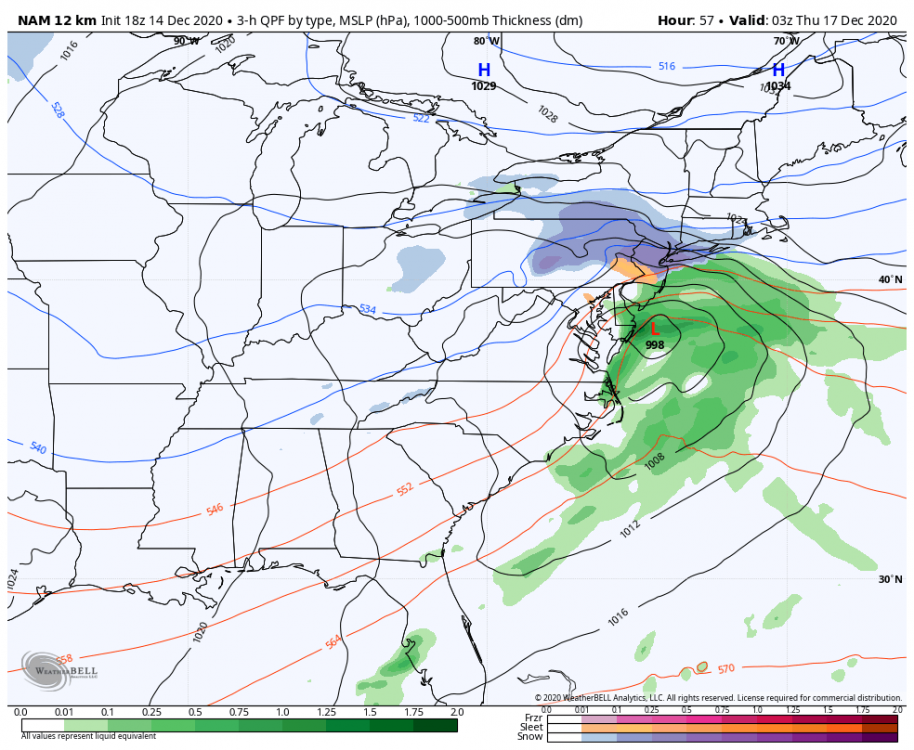
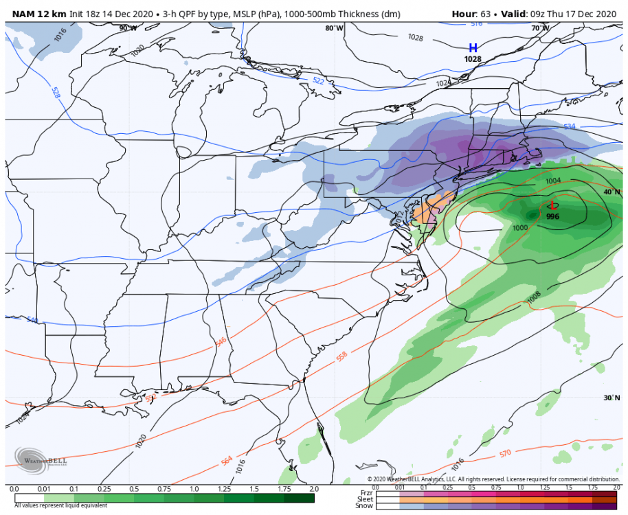
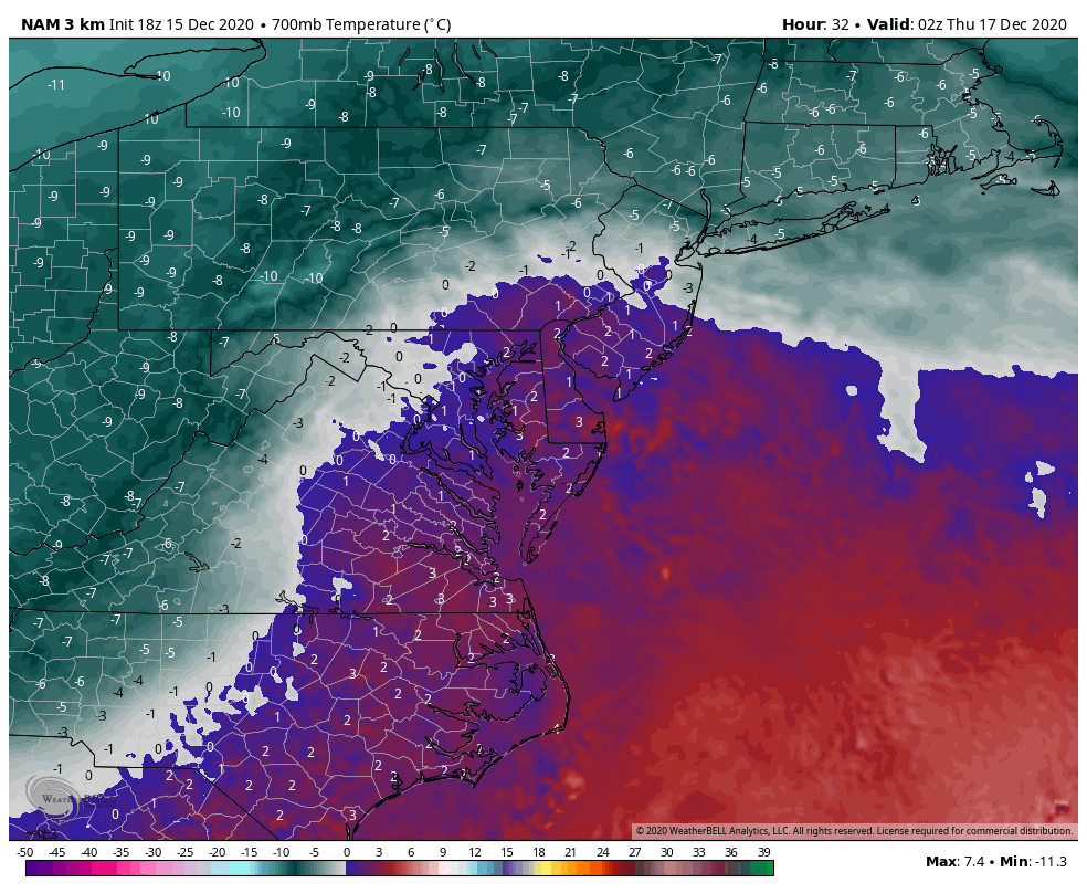
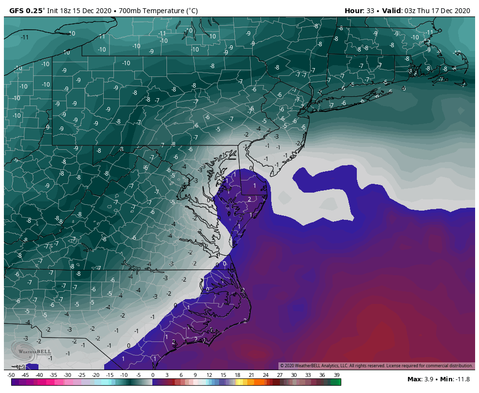
I honestly don't see much change from 12z to 18z or really anything major from model to model at 18z in terms of the surface track when comparing stuff. I'm not going to chase every random kink or secondary max in the isobars. Everyone's going to get a significant snowstorm. Where the best 700mb forcing resides is going to be where the top end snow totals are going to be found and the amount of warm advection aloft is going to determine what kind of mixing issues occur in the LSV, specifically below the turnpike.
Model's aren't quite honed in on either yet, especially the mixing. The 18z GFS basically tracked the surface low pretty much the same the 12z as did the 12 vs 18z NAM. Now NAM has looked a bit southeast of the GFS but the NAM sends a lot of sleet (3k had 1-2"+ worth) into the LSV and the GFS basically has the surface low running a straight rain/snow line.
The culprit for all of this is not at 850mb but at the 700mb level. There's a huge difference between the NAM and GFS on temps at that level.
NAM

GFS

There was a compromise to be in had in the form of the earlier 12z Euro which is tracking similar to the GFS on the surface. That was borderline at 700mb but generally stayed below freezing at that level and at 850mb where it showed mix.. like indicating a briefer intrusion of the warm nose somewhere in between those levels (probably a more reasonable assumption.
-
2
-
-
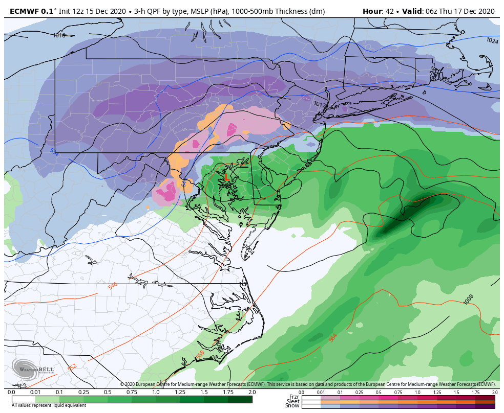
2 minutes ago, Atomixwx said:
Let's see for those of us who are cheapskates and don't want to give Joe Bastardi money lol
High water mark of the mixing at this 42 hr frame. Mixing at 39 and 42 above mason-dixon. Everyone back over at hr 45. It's hard on these 3 hr maps to really tell whats going on QPF wise but it appears to me the mixing period might conincide with a slot (or lighter precip at least) working up into the LSV, which is certainly possible with how close the low gets before fading. Euros only putting out small sleet/ice numbers and then the backside sets back again as snow. It's still going to be a significant snowfall regardless.
Hr 42
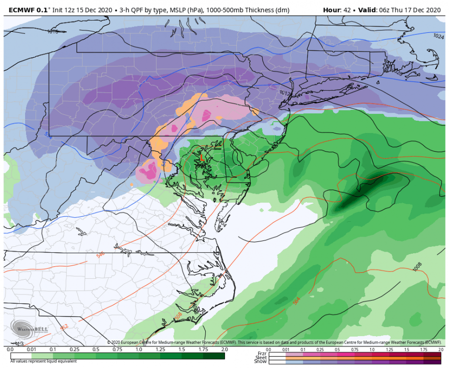
10:1 map
-
1 hour ago, jm1220 said:
Good luck out there-certainly looks based on trends like I-80 corridor and I-81 north of I-80 do very well-essentially an arc from the Catskills to UNV/AOO. Something like a 3/14/17 outcome. If these models are right, could be the first 20"+ event for UNV since 1994? There should be a hellacious band just north of that 700mb low track, deformation and plenty of lift there, along with good ratios.
Yup I think it would be. 96 and 03 came the closest with 18"ish. Nov '95 was also a 15-18" type snowstorm in UNV.
It would be the first one for me personally from an IMBY perspective since '94, which I was 6-8 years old in 92-94 so I don't really remember that golden age for big snowstorms in this corridor. Jan '96, Feb 03, and Feb '10 were all high teens storms (still great events though of course). Just missed the 20"+ by about 15-20 miles in 2016. Hard to do around here, I'll believe it when my homemade snowboard that tops out at 20" disappears tomorrow night lol.
-
2
-
-
5 minutes ago, pasnownut said:
Euro will really tip the scales IMO.
Parsing over thermal profiles, we are still safe, although SE is marginally so for a few panels. Thats going over the 700's and 850's, so while best forcing may be NW, we may depend on rates prior to any changeover for eastern locals. Were on the edge, but still have a little buffer.
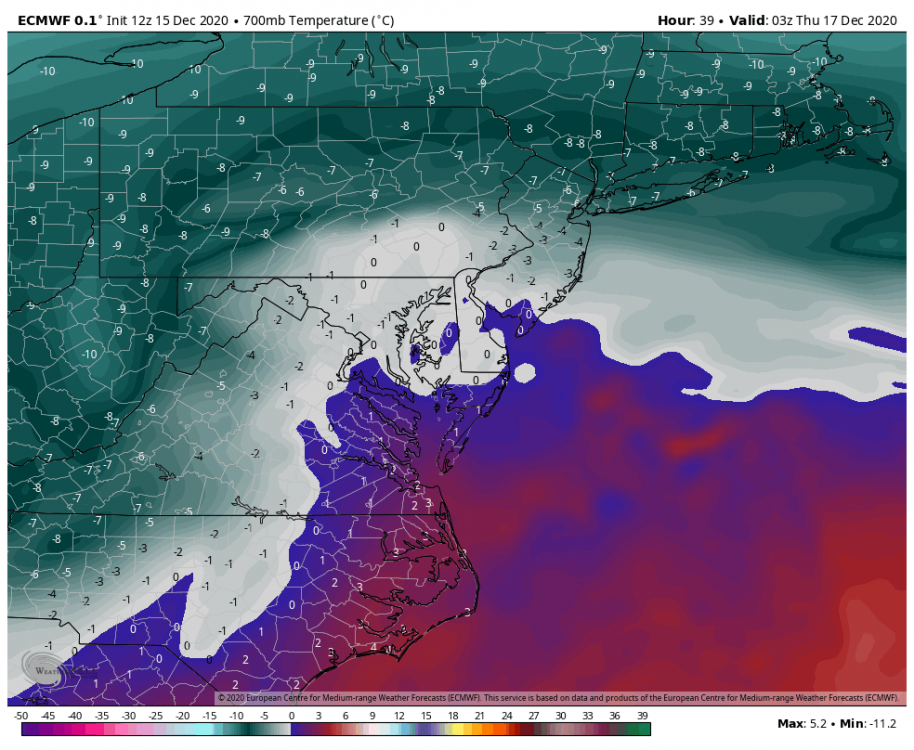
With model's seemingly starting to zero on taking the surface low essentially to the Chesapeake Bay Bridge (the Baltimore one), it's pretty likely at least the southern parts of York/Lancaster have a period mid storm where they mix. I think it'd be mainly sleet north of the mason-dixon line but a low track that close is probably going to introduce p-type issues there for a couple hours. Once the low starts to make it's fade heading toward going under Long Island and New England I think anyone mixing in PA will promptly go back to snow.
-
1
-
-
<3
QuoteHeavy snow bands will take shape during the evening hours on Wednesday. The ECMWF and NAM deterministic models suggest the easterly jet to the north of the intensifying 850mb low may intensify to as strong as 60-70 kts as it moves over eastern PA by 06z Thu. Historically, many of the heaviest snow events in this area have occurred just west of strong easterly wind anomalies, where convergence and frontogenesis forces intense upward motion within cold air. As snow bands move through central PA Wednesday night, localized snow rates of 2 to 4 inches per hour are a reasonable expectation.
-
 1
1
-
-
In other important details about this incoming barn burner, it has been named Gail.. haha.
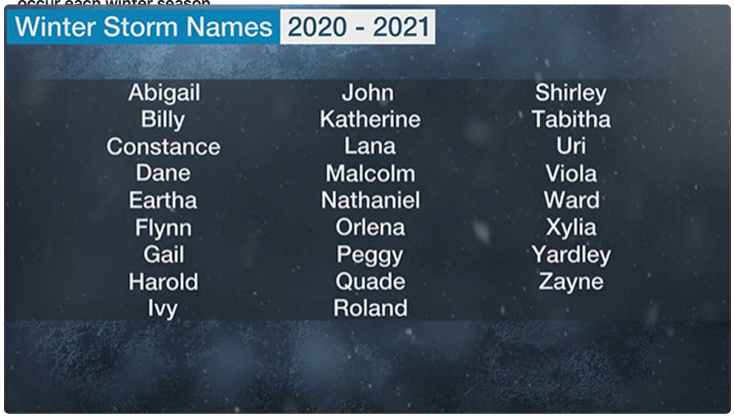
https://weather.com/safety/winter/news/2020-12-14-winter-storm-gail-noreaster-east-coast-snowstorm
-
 2
2
-
-
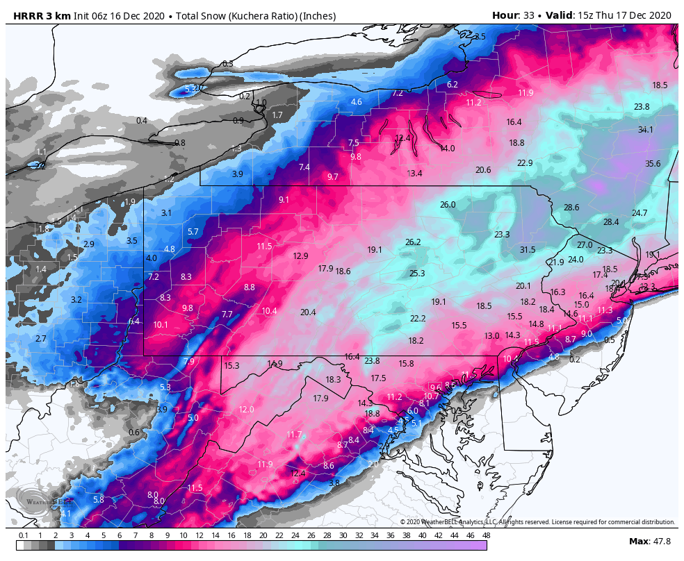
Crushed.. this gets everybody here and even gives the Pittsburgh folks warning snow. It does nose mixing (primarily sleet) up into York/Lancaster and even up towards Harrisburg mid-storm.
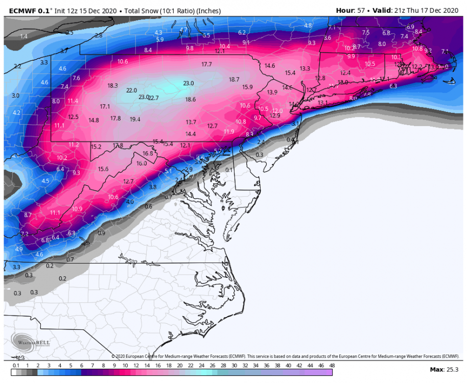
Using 10:1. Kuchera totals are 2' + in the AOO-UNV-IPT corridor.

-
1
-
-
GFS has really looked solid the last full cycle back to 0z last night. It's also tucking the low from SE VA just inside Chesapeake Bay thru the Delmarva now like the Euro has been doing, which has been solidifying our northern and NW folks into the better totals and keeping the Pittsburgh/SW PA folks in high end advisory (maybe low end warning) numbers.
-
3 minutes ago, Cashtown_Coop said:
So this would be a true Miller A?
Hmm it's still showing some surface reflection into the OH Valley on the models, so I don't know if it'd be a clear cut miller A if we're being technical. But with the coastal getting going early and tracking where it needs to for this area on pretty much all models now.. it might as well be one.
-
 1
1
-
-
1 hour ago, canderson said:
It’s frankly weird to see CTP so bullish. They have been for days.
A system originating from the Gulf states developing a coastal low tracking up the coastline near or on the Delmarva into the teeth of a strong Canadian high are what C-PA snowstorms are made of.
-
3
-
-
Just now, pasnownut said:
Blame Bastardi....everyone else does. Still love that guy.
Lol, I was using the 12k NAM since some of this event is still outside 60hrs. 3k NAM is definitely NOT acting up haha, geesh.
-
1
-
-
1 minute ago, pasnownut said:
all good. Check out thermal profile i just posted, you can see at 700 the column/best lift is SE.
Yea, my bad. it's starting to pull the heavy snow swath back towards where general consensus of the other guidance has it. Seriously though, did anyone else with WeatherBell have a screwed up 18z NAM like I did?
-
7 minutes ago, pasnownut said:
12z

18z

18z less tucked in was my point. It was a step better for mby (speaking solely on the NAM output). Thats all I'm saying. Snow map was less widespread, and a bit SE of 12z, but I guess I'm more worried about me.
Well looking at it with Weatherbell's map something was up with the model run itself on there. Def the current 18z run but it there was some of the precip shield that cut out on a couple frames, really weird.. and it's not totaling snow right either.
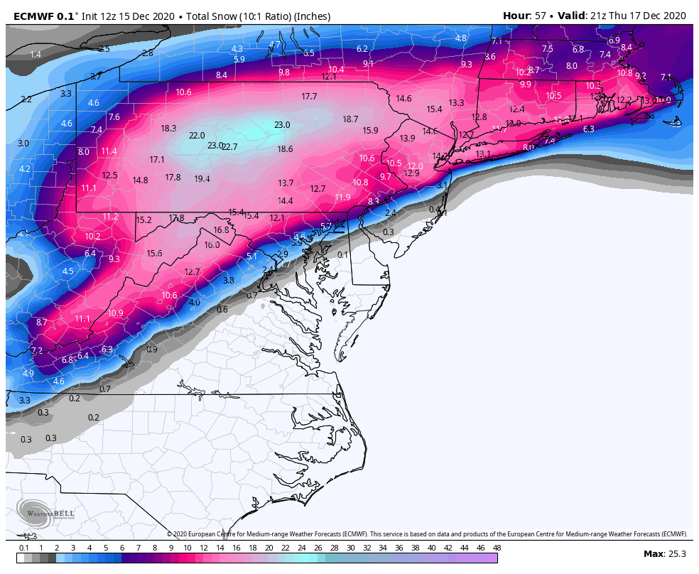
Heres what it did hr 57 vs hr 63 frames for example
57:
63
So there's definitely something up there, I know the TT maps can really exaggerate snow totals near the mix areas but it was like looking at a completely different model run lol.
-
4 minutes ago, pasnownut said:
NAM just made a nice step in the right direction. Waiting for the taboo snow maps, but I'm liking it...alot.
Eh not really, track did shift SE a bit coming up the coast but still a lot of mix in the LSV and it really shut off the precip fast once the low's gettin by us.
-
36 minutes ago, JTrout said:
For prospective, obviously a completely different storm, colder, higher ratios etc. I just heard somewhere(maybe posted here) that the Jan 2016 storm produced the 30" at MDT with less then 2" of QPf. Is that true? Anyone really good at remembering ratios from specific storms?
34 minutes ago, pasnownut said:if thats the case, you'd need to be at 18:1 kinda ratios. While not impossible, thats cold powder kinda stuff.
Yea there were definitely elevated ratios there and in that general band of the LSV that saw those 30+ totals. Jan 2016 was a colder system but if you have a good snow column with no real warm nose in it (enough to affect the snowflake structure) and any typical surface temps cold enough for snow to accumulate well... the thing that matters more for ratios is where in the column the lift is occurring and what the temperatures are at that particular layer. For this, the better ratios will probably be where the best lift is at the 700mb level (and somewhat above) and where 850mb temps don't flirt with 0ºC.
-
39 minutes ago, canderson said:
Just curious - what type of storm system would it take to get the entire state into warning criteria snow? Is it even possible for the far eastern zones and the far west/Erie to get clobbered by the same event?
Yea this is where we have to be careful. It's definitely possible with this event in terms of having a widespread area of 6"+ like that. Again the big question for this subforum in particular is not really whether all of us see decent snow totals but where the swath of heavy to excessive snow is, and how expansive... with the secondary question being how much if any mixing gets into York/Lancaster counties. I tend to think any swath of widespread 14-18"+ amounts may be more focused than the broad swath the Euro is presenting, with the majority of the rest of us NW to 2001kx in Clearfield in the 6-12" range. Models are still kind of up in the air about that. Canadian is still the tightest of the bunch and has the excessive snow swath only really in the LSV from H-burg and SE out to Allentown and really hurts the folks back this way in JST/AOO/UNV taking away the bigger event and beyond in western PA. Canadian ensemble has the swath somewhere in between the GEFS and Euro EPS though. NAM is way NW with the mixing line and heavy snow swath (probably too much so). GFS does okay, its starting to hug the coast a bit more but still has a more outside track on approach. Euro is pretty far inside, actually inside the Chesapeake Bay across the Delmarva to Delaware Bay with it's low on the way up the coast. It's actually pretty much what the NAM did track wise, except the NAM was much warmer thermally.
-
The more elevation dependent HRRR ended up being correct over the other ambitious guidance this morning. Probably could call it a T here, but nothing measurable fell. Looks like it stuck from about 1800’ or so up.
Looking NE
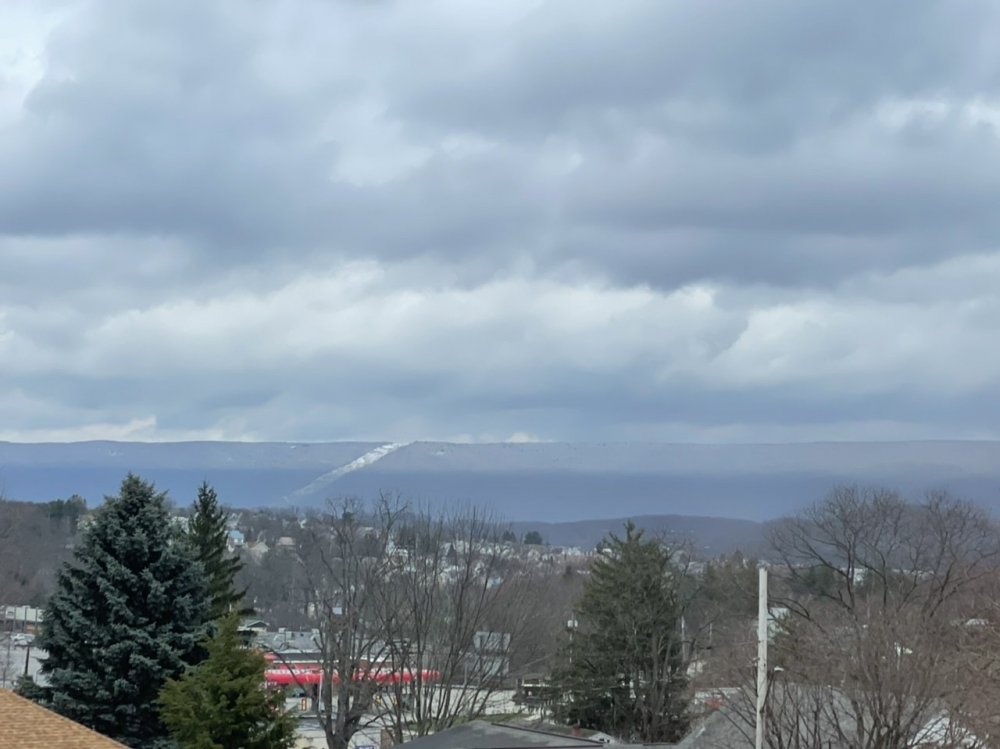
Good thing we might just scrounge up a bit of snow Wednesday lol. Did anyone actually see much this morning?
-
Steadier precip has arrived, looks like a rain/snow mix currently. 37ºF
-
Euro's hanging the deform max in between I-99 and I-81 this run, everyone in here's crushed.
-
1
-
1
-

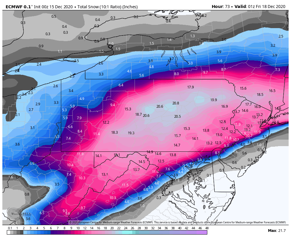


December 16 2020 CTP Snowstorm Disco and Obs
in Upstate New York/Pennsylvania
Posted
Light snow has just gotten started here, a bit ahead of schedule.